Construct a KML document and save it as a KMZ file.
Use case
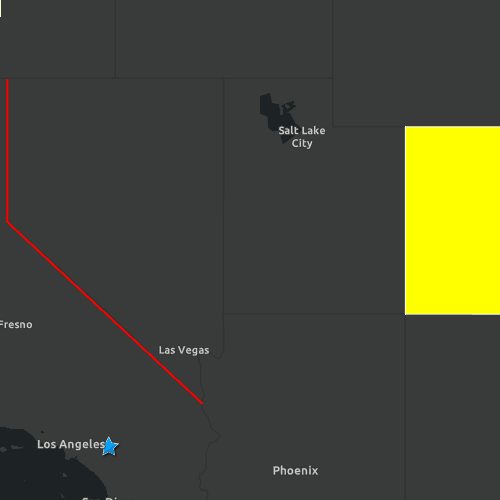
If you need to create and save data on the fly, you can use KML to create points, lines, and polygons and then serializing them as KML nodes in a KML Document. Once complete, you can share the KML data with others that are using a KML reading application, such as ArcGIS Earth.
How to use the sample
Application opens to a view of the Southwestern United States. Click on the "Save KMZ file" button to save the active KML document as a .kmz file on your system.
How it works
- Create a
Point,Polyline, andPolygon. - Create a
Graphicfor each and add it to theGraphicsOverlay - Create a
KmlGeometryobject using theGeometryfrom the point, line, and polygon. - Create a
KmlPlacemarkfor each kml geometry. - Set a
KmlStylefor each placemark. - Add all three kml placemarks to the
KmlDocument. - Save the kml document to a file using the
saveAsfunction.
Relevant API
- KmlDocument
- KmlGeometry
- KmlIcon
- KmlIconStyle
- KmlLineStyle
- KmlNode.saveAs
- KmlPlacemark
- KmlPolygonStyle
- KmlStyle
Tags
Keyhole, KML, KMZ, OGC
Sample Code
CreateAndSaveKmlFile.qml
// [WriteFile Name=CreateAndSaveKmlFile, Category=Layers]
// [Legal]
// Copyright 2019 Esri.
// Licensed under the Apache License, Version 2.0 (the "License");
// you may not use this file except in compliance with the License.
// You may obtain a copy of the License at
// http://www.apache.org/licenses/LICENSE-2.0
// Unless required by applicable law or agreed to in writing, software
// distributed under the License is distributed on an "AS IS" BASIS,
// WITHOUT WARRANTIES OR CONDITIONS OF ANY KIND, either express or implied.
// See the License for the specific language governing permissions and
// limitations under the License.
// [Legal]
import QtQuick
import QtQuick.Controls
import QtQuick.Dialogs
import Esri.ArcGISRuntime
import Esri.ArcGISExtras
Rectangle {
id: rootRectangle
clip: true
width: 800
height: 600
property url fileSavePath: ""
MapView {
id: mapView
anchors.fill: parent
Component.onCompleted: {
// Set the focus on MapView to initially enable keyboard navigation
forceActiveFocus();
}
Map {
Basemap {
initStyle: Enums.BasemapStyleArcGISDarkGray
}
// add a KML Layer
KmlLayer {
KmlDataset {
id: kmlDataset
KmlDocument {
id: kmlDocument
name: qsTr("KML Sample Document")
onSaveStatusChanged: {
if (saveStatus === Enums.TaskStatusErrored) {
console.log(`Error: ${error.message} - ${error.additionalMessage}`);
}
else if (saveStatus === Enums.TaskStatusCompleted) {
saveCompleteDialog.open();
}
}
}
}
}
// set initial extent
ViewpointExtent {
Envelope {
id: myViewpoint
xMin: -123.0
yMin: 33.5
xMax: -101.0
yMax: 42.0
spatialReference: SpatialReference { wkid: 4326 }
}
}
}
}
Button {
anchors{
left: parent.left
top: parent.top
margins: 3
}
text: qsTr("Save kmz file")
onClicked: {
fileSavePath = System.temporaryFolder.url + "/KmlSampleFile_%1.kmz".arg((new Date().getTime() % 1000).toString());
kmlDocument.saveAs(fileSavePath);
}
}
PolygonBuilder {
id: polygonBuilder
spatialReference: SpatialReference { wkid: 4326 }
}
PolylineBuilder {
id: polylineBuilder
spatialReference: SpatialReference { wkid: 4326 }
}
Point {
id: point
x: -117.195800
y: 34.056295
spatialReference: SpatialReference { wkid: 4326 }
}
BusyIndicator {
id: busy
anchors.centerIn: parent
visible: kmlDocument.saveStatus === Enums.TaskStatusInProgress
}
Dialog {
id: saveCompleteDialog
anchors.centerIn: parent
width: parent.width * .8
standardButtons: Dialog.Ok
title: "Item saved to temporary location:"
Label {
text: fileSavePath
wrapMode: Text.Wrap
width: parent.width
}
}
KmlStyle {
id: kmlStyleWithPointStyle
KmlIconStyle {
KmlIcon {
url: "https://static.arcgis.com/images/Symbols/Shapes/BlueStarLargeB.png"
}
scale: 1
}
}
KmlStyle {
id: kmlStyleWithLineStyle
KmlLineStyle {
color: "red"
width: 2
}
}
KmlStyle {
id: kmlStyleWithPolygonStyle
KmlPolygonStyle {
color: "yellow"
}
}
Component.onCompleted: {
createPolygon();
createPolyline();
createPoint();
}
function createPoint() {
addToKmlDocument(point, kmlStyleWithPointStyle);
}
function createPolygon() {
polygonBuilder.addPointXY(-109.048, 40.998);
polygonBuilder.addPointXY(-102.047, 40.998);
polygonBuilder.addPointXY(-102.037, 36.989);
polygonBuilder.addPointXY(-109.048, 36.998);
addToKmlDocument(polygonBuilder.geometry, kmlStyleWithPolygonStyle);
}
function createPolyline() {
polylineBuilder.addPointXY(-119.992, 41.989);
polylineBuilder.addPointXY(-119.994, 38.994);
polylineBuilder.addPointXY(-114.620, 35.0);
addToKmlDocument(polylineBuilder.geometry, kmlStyleWithLineStyle);
}
function addToKmlDocument(geometry, kmlStyle) {
const kmlGeometry = ArcGISRuntimeEnvironment.createObject("KmlGeometry", {
geometry: geometry,
altitudeMode: Enums.KmlAltitudeModeClampToGround
});
const kmlPlacemark = ArcGISRuntimeEnvironment.createObject("KmlPlacemark");
kmlPlacemark.geometriesListModel.append(kmlGeometry);
kmlPlacemark.style = kmlStyle;
kmlDocument.childNodesListModel.append(kmlPlacemark);
}
}