Clip a geometry with another geometry.
Use case
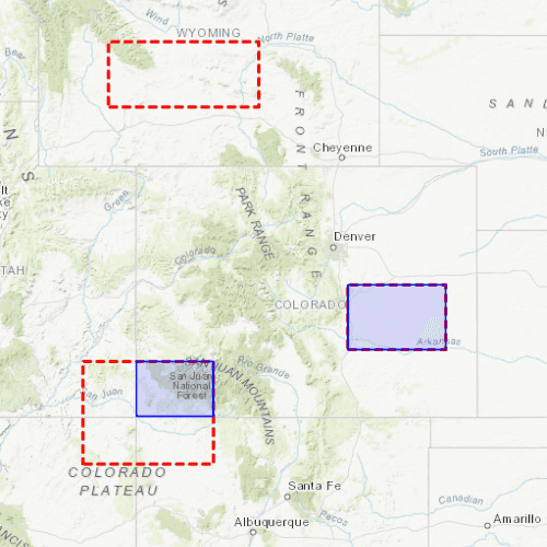
Create a new set of geometries for analysis (e.g. displaying buffer zones around abandoned coal mine shafts in an area of planned urban development) by clipping intersecting geometries.
How to use the sample
Click the "Clip" button to clip the blue graphic with the red dashed envelopes.
How it works
- Create a
GraphicsOverlayand add aGraphiccontaining an envelope. - Create another
GraphicsOverlaythat contains three other envelopes: one that intersects a part of the first graphic, one that is entirely within it, and another completely outside of it. - Create a third
GraphicsOverlaybut add no graphics to it. - Create a Button that, when clicked, calls a function that hides the main graphic. In the same function, iterate through the
GraphicsOverlaythat contains the three envelopes and callGeometryEngine.clipfor eachEnvelope, by passing in the main graphic'sGeometryand the currentEnvelopeas arguments. - Add each clipped
Geometrygraphic to the emptyGraphicsOverlayto visualize the clipped geometries.
Relevant API
- Envelope
- Geometry
- GeometryEngine.clip
- Graphic
- GraphicsOverlay
Additional information
Note: the resulting geometry may be null if the envelope does not intersect the geometry being clipped.
Tags
analysis, clip, geometry
Sample Code
ClipGeometry.qml
// [WriteFile Name=ClipGeometry, Category=Geometry]
// [Legal]
// Copyright 2018 Esri.
// Licensed under the Apache License, Version 2.0 (the "License");
// you may not use this file except in compliance with the License.
// You may obtain a copy of the License at
// http://www.apache.org/licenses/LICENSE-2.0
// Unless required by applicable law or agreed to in writing, software
// distributed under the License is distributed on an "AS IS" BASIS,
// WITHOUT WARRANTIES OR CONDITIONS OF ANY KIND, either express or implied.
// See the License for the specific language governing permissions and
// limitations under the License.
// [Legal]
import QtQuick
import QtQuick.Controls
import Esri.ArcGISRuntime
Rectangle {
id: rootRectangle
clip: true
width: 800
height: 600
MapView {
id: mapView
anchors.fill: parent
Component.onCompleted: {
// Set the focus on MapView to initially enable keyboard navigation
forceActiveFocus();
}
Map {
Basemap {
initStyle: Enums.BasemapStyleArcGISTopographic
}
initialViewpoint: vc
// Create the envelope for Colorado
Envelope {
id: coloradoGeometry
xMax: -11362327.128340
xMin: -12138232.018408
yMin: 4441198.773776
yMax: 5012861.290274
spatialReference: SpatialReference {
wkid: 3857
}
}
// Create the dotted outline for the clipping envelopes
SimpleLineSymbol {
id: redOutline
style: Enums.SimpleLineSymbolStyleDash
color: "#FFFF0000"
width: 3
}
// Create the outline and fill for Colorado
SimpleFillSymbol {
id: coloradoFillSymbol
color: "#220000FF"
style: Enums.SimpleFillSymbolStyleSolid
SimpleLineSymbol {
color: "#FF0000FF"
width: 2.0
style: Enums.SimpleFillSymbolStyleSolid
}
}
}
ViewpointCenter {
id: vc
center: Point {
x: -11655182.595204
y: 4741618.772994
spatialReference: SpatialReference {
wkid: 3857
}
}
targetScale: 15151632
}
// Create an envelope outside of Colorado
Envelope {
id: outsideEnvelope
xMax: -11858344.321294
xMin: -12201990.219681
yMax: 5297071.577304
yMin: 5147942.225174
spatialReference: SpatialReference {
wkid: 3857
}
}
// Create an envelope intersecting Colorado
Envelope {
id: intersectingEnvelope
xMax: -11962086.479298
xMin: -12260345.183558
yMax: 4566553.881363
yMin: 4332053.378376
spatialReference: SpatialReference {
wkid: 3857
}
}
// Create an envelope inside of Colorado
Envelope {
id: containedEnvelope
xMax: -11431488.567009
xMin: -11655182.595204
yMax: 4741618.772994
yMin: 4593570.068343
spatialReference: SpatialReference {
wkid: 3857
}
}
// Create a graphics overlay for the Colorado geometry
GraphicsOverlay {
id: coloradoOverlay
// Colorado
Graphic {
id: coloradoGraphic
geometry: coloradoGeometry
symbol: coloradoFillSymbol
}
}
// Create a graphics overlay to contain the clipping envelopes
GraphicsOverlay {
id: envelopesOverlay
// Outside envelope
Graphic {
id: outsideEnvelopeGraphic
geometry: outsideEnvelope
symbol: redOutline
}
// Intersecting envelope
Graphic {
id: intersectingEnvelopeGraphic
geometry: intersectingEnvelope
symbol: redOutline
}
// Contained envelope
Graphic {
id: containedEnvelopeGraphic
geometry: containedEnvelope
symbol: redOutline
}
}
// Create a graphics overlay for the clipped graphics
GraphicsOverlay {
id: clippedAreasOverlay
}
}
// Create a button that clips the geometry into the envelopes
Button {
id: clipOrResetButton
anchors {
horizontalCenter: parent.horizontalCenter
bottom: parent.bottom
bottomMargin: 25
}
text: "Clip"
onClicked: {
if (clipOrResetButton.text === "Clip")
{
// Immediately hide the Colorado graphic to prevent overlap
coloradoOverlay.visible = false;
// Iterate through the clipping envelopes
envelopesOverlay.graphics.forEach(graphic => {
// Create a variable that contains the clip result, which is an envelope of the overlap between colorado and the current graphic
const clippedGeometry = GeometryEngine.clip(coloradoGraphic.geometry, graphic.geometry.extent);
if (clippedGeometry !== null) {
// Create a new graphic using the clip envelope, and fill it in with the colorado fill symbol
const clippedGraphic = ArcGISRuntimeEnvironment.createObject("Graphic", { geometry: clippedGeometry, symbol: coloradoFillSymbol });
// Add the new clipped graphic to the map
clippedAreasOverlay.graphics.append(clippedGraphic);
}
});
clipOrResetButton.text = "Reset";
}
else
{
clipOrResetButton.text = "Clip";
coloradoOverlay.visible = true;
clippedAreasOverlay.graphics.clear();
}
}
}
}