Apply a raster function to a local raster file and display the output with a raster layer.
Use case
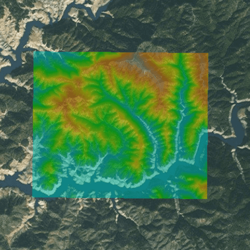
Raster functions allow processing operations that can be applied to one or more rasters on the fly. A land survey agency may apply hillshade and aspect functions to rasters with elevation data in order to better determine the topography of a landscape and to make further planning decisions.
How to use the sample
Load the sample to see a raster function applied to a raster.
How it works
- Create a
RasterFunctionusing the path to a local raster function JSON file. - Set the raster function arguments as required by the function used.
- Use the raster function to create a new
Raster. - Set the raster to a
RasterLayerand display it in theMap.
Relevant API
- Raster
- RasterFunction
- RasterLayer
Offline data
| Link | Local Location |
|---|---|
| Shasta.tif raster | <userhome>/ArcGIS/Runtime/Data/raster/Shasta_Elevation.tif |
| color.json raster function | <userhome>/ArcGIS/Runtime/Data/raster/color.json |
About the data
The raster function in the provided JSON file blends a color image with a greyscale image (in this case, a raster image containing elevation data), to add a hillshade effect to the input raster.
Additional information
Learn more about raster functions in the ArcGIS Pro documentation.
Tags
analysis, function, image, layer, processing, raster, raster function, transformation
Sample Code
// [WriteFile Name=RasterFunctionFile, Category=Layers]
// [Legal]
// Copyright 2017 Esri.
// Licensed under the Apache License, Version 2.0 (the "License");
// you may not use this file except in compliance with the License.
// You may obtain a copy of the License at
// http://www.apache.org/licenses/LICENSE-2.0
// Unless required by applicable law or agreed to in writing, software
// distributed under the License is distributed on an "AS IS" BASIS,
// WITHOUT WARRANTIES OR CONDITIONS OF ANY KIND, either express or implied.
// See the License for the specific language governing permissions and
// limitations under the License.
// [Legal]
import QtQuick
import Esri.ArcGISRuntime
import Esri.ArcGISExtras
Rectangle {
id: rootRectangle
clip: true
width: 800
height: 600
property real scaleFactor: 1
readonly property url dataPath: {
Qt.platform.os === "ios" ?
System.writableLocationUrl(System.StandardPathsDocumentsLocation) + "/ArcGIS/Runtime/Data/raster" :
System.writableLocationUrl(System.StandardPathsHomeLocation) + "/ArcGIS/Runtime/Data/raster"
}
property url rasterPath: dataPath + "/Shasta_Elevation.tif"
MapView {
id: mapView
anchors.fill: parent
Component.onCompleted: {
// Set the focus on MapView to initially enable keyboard navigation
forceActiveFocus();
}
Map {
Basemap {
initStyle: Enums.BasemapStyleArcGISImageryStandard
}
RasterLayer {
id: rasterLayer
opacity: 0.5
Raster {
id: theRaster
path: rasterPath
}
}
ViewpointExtent {
Envelope {
json: {
"spatialReference": {
"latestWkid": 3857,
"wkid": 102100
},
"xmax": -13591503.517810356,
"xmin": -13606233.44023646,
"ymax": 4982810.138527592,
"ymin": 4971762.696708013
}
}
}
}
}
// Create a button to apply the raster function
Rectangle {
id: button
enabled: theRaster.loadStatus === Enums.LoadStatusLoaded
property bool pressed: false
anchors {
right: parent.right
bottom: parent.bottom
rightMargin: 20 * scaleFactor
bottomMargin: 40 * scaleFactor
}
width: 45 * scaleFactor
height: width
color: pressed ? "#959595" : "#D6D6D6"
radius: 100
border {
color: "#585858"
width: 1 * scaleFactor
}
Image {
anchors {
centerIn: parent
verticalCenterOffset: -3 * scaleFactor
}
width: 26 * scaleFactor
height: width
source: "qrc:/Samples/Layers/RasterFunctionFile/color.png"
}
MouseArea {
anchors.fill: parent
onPressed: button.pressed = true
onReleased: button.pressed = false
onClicked: applyRasterFunction()
}
}
//! [RasterFunctionFile qml raster from function]
function applyRasterFunction() {
// create raster function
const rasterFunction = createRasterFunction();
// check for valid raster function
if (!rasterFunction)
return;
// create the raster from the raster function
const raster = ArcGISRuntimeEnvironment.createObject("Raster", { rasterFunction: rasterFunction });
// create raster layer from raster
const newRasterLayer = ArcGISRuntimeEnvironment.createObject("RasterLayer", { raster: raster });
newRasterLayer.opacity = 0.5;
// add raster to map
mapView.map.operationalLayers.clear();
mapView.map.operationalLayers.append(newRasterLayer);
}
function createRasterFunction() {
// Check if the raster function json exists
if (!colorJson.exists)
return;
// create the raster function
const rasterFunction = ArcGISRuntimeEnvironment.createObject("RasterFunction", {path: dataPath + "/color.json"});
// check for valid raster function
if (!rasterFunction)
return;
rasterFunction.arguments.setRaster("raster", theRaster);
rasterFunction.arguments.setRaster("raster", theRaster);
return rasterFunction;
}
FileInfo {
id: colorJson
url: dataPath + "/color.json"
}
//! [RasterFunctionFile qml raster from function]
}