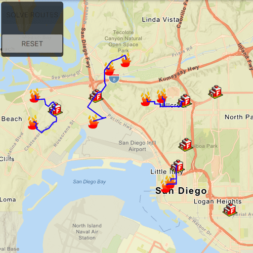
Find routes from several locations to the respective closest facility.
Use case
Quickly and accurately determining the most efficient route between a location and a facility is a frequently encountered task. For example, a city's fire department may need to know which fire stations in the vicinity offer the quickest routes to multiple fires. Solving for the closest fire station to the fire's location using an impedance of "travel time" would provide this information.
How to use the sample
Click 'Solve Routes' to solve and display the route from each incident (fire) to the nearest facility (fire station). Click 'Reset' to clear the results.
How it works
- Create a
ClosestFacilityTaskusing a URL from an online service. - Get the default set of
ClosestFacilityParametersfrom the task:closestFacilityTask.createDefaultParameters(). - Create
ServiceFeatureTables for both facilities incidents. - Add all facilities to the task parameters:
closestFacilityParameters.setFacilitiesWithFeatureTable(facilitiesFeatureTable, parameters). - Add all incidents to the task parameters:
closestFacilityParameters.setIncidentsWithFeatureTable(incidentsFeatureTable, parameters). - Get
ClosestFacilityResultby solving the task with the provided parameters:closestFacilityTask.solveClosestFacility(closestFacilityParameters). - Find the closest facility for each incident by iterating over the list of
Incidents. - Display the route as a
Graphicusing theclosestFacilityRoute.routeGeometry().
Relevant API
- ClosestFacilityParameters
- ClosestFacilityResult
- ClosestFacilityRoute
- ClosestFacilityTask
- Facility
- Graphic
- GraphicsOverlay
- Incident
Tags
incident, network analysis, route, search
Sample Code
FindClosestFacilityToMultipleIncidentsService.qml
// [WriteFile Name=FindClosestFacilityToMultipleIncidentsService, Category=Routing]
// [Legal]
// Copyright 2019 Esri.
// Licensed under the Apache License, Version 2.0 (the "License");
// you may not use this file except in compliance with the License.
// You may obtain a copy of the License at
// http://www.apache.org/licenses/LICENSE-2.0
// Unless required by applicable law or agreed to in writing, software
// distributed under the License is distributed on an "AS IS" BASIS,
// WITHOUT WARRANTIES OR CONDITIONS OF ANY KIND, either express or implied.
// See the License for the specific language governing permissions and
// limitations under the License.
// [Legal]
import QtQuick
import Esri.ArcGISRuntime
import QtQuick.Controls
import QtQuick.Layouts
Rectangle {
id: rootRectangle
clip: true
width: 800
height: 600
property bool busy: false
property var mySetViewpointTaskId
property var facilityParams: null
signal bothDoneLoading(var facilityLoadStatus, var incidentLoadStatus)
property bool layersLoaded : (facilitiesLayer.loadStatus === Enums.LoadStatusLoaded) && (incidentsLayer.loadStatus === Enums.LoadStatusLoaded)
MapView {
id: mapView
anchors.fill: parent
Component.onCompleted: {
// Set the focus on MapView to initially enable keyboard navigation
forceActiveFocus();
}
Map {
Basemap {
initStyle: Enums.BasemapStyleArcGISStreetsRelief
}
FeatureLayer {
id: facilitiesLayer
ServiceFeatureTable {
id: facilitiesFeatureTable
url: "https://services2.arcgis.com/ZQgQTuoyBrtmoGdP/ArcGIS/rest/services/San_Diego_Facilities/FeatureServer/0"
}
renderer: SimpleRenderer {
symbol: facilitySymbol
}
onLoadStatusChanged: setViewpointGeometry();
}
FeatureLayer {
id: incidentsLayer
ServiceFeatureTable {
id: incidentsFeatureTable
url: "https://services2.arcgis.com/ZQgQTuoyBrtmoGdP/ArcGIS/rest/services/San_Diego_Incidents/FeatureServer/0"
}
renderer: SimpleRenderer {
symbol: incidentSymbol
}
onLoadStatusChanged: setViewpointGeometry();
}
Component.onCompleted: busy = true;
}
GraphicsOverlay {
id: resultsOverlay
}
Rectangle {
anchors {
margins: 5
left: parent.left
top: parent.top
}
width: childrenRect.width
height: childrenRect.height
color: "#000000"
opacity: .70
radius: 5
// catch mouse signals from propagating to parent
MouseArea {
anchors.fill: parent
onClicked: mouse => mouse.accepted = true
onWheel: wheel => wheel.accepted = true
}
ColumnLayout {
Button {
id: solveButton
text: qsTr("Solve Routes")
Layout.margins: 2
Layout.fillWidth: true
enabled: false
onClicked: {
busy = true;
solveButton.enabled = false;
task.solveClosestFacility(facilityParams);
}
}
Button {
id: resetButton
text: qsTr("Reset")
Layout.margins: 2
Layout.fillWidth: true
enabled: false
onClicked: {
resultsOverlay.graphics.clear();
solveButton.enabled = true;
resetButton.enabled = false;
}
}
}
}
}
PictureMarkerSymbol {
id: facilitySymbol
url: "https://static.arcgis.com/images/Symbols/SafetyHealth/FireStation.png"
height: 30
width: 30
}
PictureMarkerSymbol {
id: incidentSymbol
url: "https://static.arcgis.com/images/Symbols/SafetyHealth/esriCrimeMarker_56_Gradient.png"
height: 30
width: 30
}
SimpleLineSymbol {
id: routeSymbol
style: Enums.SimpleLineSymbolStyleSolid
color: "blue"
width: 2.0
}
ClosestFacilityTask {
id: task
url: "https://sampleserver6.arcgisonline.com/arcgis/rest/services/NetworkAnalysis/SanDiego/NAServer/ClosestFacility"
onLoadStatusChanged: {
if (loadStatus !== Enums.LoadStatusLoaded)
return;
task.createDefaultParameters();
}
onCreateDefaultParametersStatusChanged: {
if (createDefaultParametersStatus !== Enums.TaskStatusCompleted)
return;
busy = false;
solveButton.enabled = true;
facilityParams = createDefaultParametersResult;
facilityParams.setFacilitiesWithFeatureTable(facilitiesFeatureTable, params);
facilityParams.setIncidentsWithFeatureTable(incidentsFeatureTable, params);
}
onSolveClosestFacilityStatusChanged: {
if (solveClosestFacilityStatus !== Enums.TaskStatusCompleted)
return;
// finding the closest facility for each incident to create a route graphic between each pair
for (let incidentIndex = 0; incidentIndex < incidentsFeatureTable.numberOfFeaturesAsInt; incidentIndex++) {
const closestFacilityIndex = solveClosestFacilityResult.rankedFacilityIndexes(incidentIndex)[0];
const route = solveClosestFacilityResult.route(closestFacilityIndex, incidentIndex);
const routeGraphic = ArcGISRuntimeEnvironment.createObject("Graphic", { geometry: route.routeGeometry, symbol: routeSymbol});
resultsOverlay.graphics.append(routeGraphic);
}
busy = false;
resetButton.enabled = true;
}
onErrorChanged: console.log(error.message);
}
QueryParameters {
id: params
whereClause: "1=1"
}
BusyIndicator {
anchors.centerIn: parent
running: busy
}
function setViewpointGeometry() {
// proceed only if both layers are loaded
if ((facilitiesLayer.loadStatus !== Enums.LoadStatusLoaded) || (incidentsLayer.loadStatus !== Enums.LoadStatusLoaded))
return;
// return if set viewpoint has been executed already
if (mySetViewpointTaskId)
return;
mySetViewpointTaskId = mapView.setViewpointGeometryAndPadding(GeometryEngine.unionOf(facilitiesLayer.fullExtent, incidentsLayer.fullExtent), 20);
task.load();
}
}