View an integrated mesh layer from a scene service.
Use case
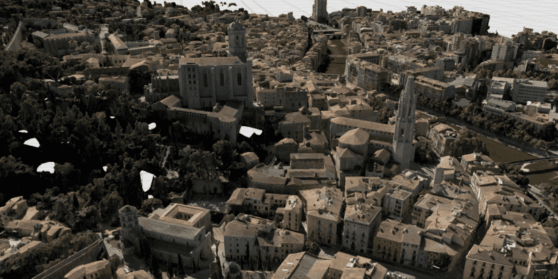
An integrated mesh is used to generate a mesh over a point dataset. They are most often used on high-density point datasets to create a high-resolution seamless surface.
How to use the sample
After launching the sample, watch the integrated mesh layer load in place. Navigate around the scene to visualize the high level of detail on the buildings.
How it works
- Create an
ArcGISScene. - Create an
IntegratedMeshLayerwith the URL to an integrated mesh layer scene service. - Add the layer to the scene's operational layers.
Relevant API
- IntegratedMeshLayer
About the data
This integrated mesh depicts the city of Girona, Spain and is attributed to the Institut Cartogràfic i Geològic de Catalunya (ICGC). The data was produced from photogrammetrically correct imagery. Areas of white space within the integrated mesh are areas that had poor overlapping coverage from photos.
Additional information
An integrated mesh layer can also be added to a scene from a local data source - either from a scene layer package (.slpk) or a mobile scene package (.mspk).
Tags
3D, integrated mesh, layers
Sample Code
/*
* Copyright 2019 Esri.
*
* Licensed under the Apache License, Version 2.0 (the "License"); you may not
* use this file except in compliance with the License. You may obtain a copy of
* the License at
*
* http://www.apache.org/licenses/LICENSE-2.0
*
* Unless required by applicable law or agreed to in writing, software
* distributed under the License is distributed on an "AS IS" BASIS, WITHOUT
* WARRANTIES OR CONDITIONS OF ANY KIND, either express or implied. See the
* License for the specific language governing permissions and limitations under
* the License.
*/
package com.esri.samples.add_an_integrated_mesh_layer;
import javafx.application.Application;
import javafx.scene.Scene;
import javafx.scene.layout.StackPane;
import javafx.stage.Stage;
import com.esri.arcgisruntime.layers.IntegratedMeshLayer;
import com.esri.arcgisruntime.mapping.ArcGISScene;
import com.esri.arcgisruntime.mapping.view.Camera;
import com.esri.arcgisruntime.mapping.view.SceneView;
public class AddAnIntegratedMeshLayerSample extends Application {
private SceneView sceneView;
@Override
public void start(Stage stage) {
try {
// set the title and size of the stage and show it
stage.setTitle("Add An Integrated Mesh Layer Sample");
stage.setWidth(800);
stage.setHeight(700);
// create a JavaFX scene with a stack pane and set it to the stage
StackPane stackPane = new StackPane();
Scene fxScene = new Scene(stackPane);
stage.setScene(fxScene);
stage.show();
// create a scene
ArcGISScene scene = new ArcGISScene();
// create a scene view and set the scene to it
sceneView = new SceneView();
sceneView.setArcGISScene(scene);
// create an integrated mesh layer of Girona, Spain and add it to the scene's operational layers
IntegratedMeshLayer integratedMeshLayer = new IntegratedMeshLayer("https://tiles.arcgis" +
".com/tiles/z2tnIkrLQ2BRzr6P/arcgis/rest/services/Girona_Spain/SceneServer");
scene.getOperationalLayers().add(integratedMeshLayer);
// set a camera position on the scene view
sceneView.setViewpointCamera(new Camera(41.9906, 2.8259, 200.0, 190.0, 65.0, 0));
// add the scene view to the stack pane
stackPane.getChildren().add(sceneView);
} catch (Exception e) {
// on any error, display the stack trace.
e.printStackTrace();
}
}
/**
* Stops and releases all resources used in application.
*/
@Override
public void stop() {
if (sceneView != null) {
sceneView.dispose();
}
}
/**
* Opens and runs application.
*
* @param args arguments passed to this application
*/
public static void main(String[] args) {
Application.launch(args);
}
}