Create, query and edit a specific server version using service geodatabase.
Use case
Workflows often progress in discrete stages, with each stage requiring the allocation of a different set of resources and business rules. Typically, each stage in the overall process represents a single unit of work, such as a work order or job. To manage these, you can create a separate, isolated version and modify it. Once this work is complete, you can integrate the changes into the default version.
How to use the sample
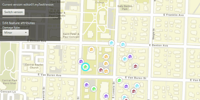
Once loaded, the map will zoom to the extent of the feature layer. The current version is indicated in the top left corner of the map. You can create a new version by specifying the version information (name, access, and description) in the form in the top right corner, and then clicking "Create version". See the Additional Information section for restrictions on the version name.
Select a feature using the primary mouse button to edit an attribute and/or click again with the secondary mouse button to relocate the point.
Click the "Switch version" button in the top left corner to switch back and forth between the version you created and the default version. Edits will automatically be applied to your version when switching to the default version.
How it works
- Create and load a
ServiceGeodatabasewith a feature service URL that has enabled Version Management. - Get the
ServiceFeatureTablefrom the service geodatabase. - Create a
FeatureLayerfrom the service feature table. - Create
ServiceVersionParameterswith a unique name,VersionAccess, and description.- Note - See the additional information section for more restrictions on the version name.
- Create a new version by calling
ServiceGeodatabase.createVersionAsync()and passing in the service version parameters. - Retrieve the result of the async call, to obtain the
ServiceVersionInfoof the version created. - Switch to the version you have just created using
ServiceGeodatabase.switchVersionAsync(), passing in the version name obtained from the service version info. - Select a
Featurefrom the map to edit its "TYPDAMAGE" attribute and location. - Apply these edits to your version by calling
ServiceGeodatabase.applyEditsAsync().
Relevant API
- FeatureLayer
- ServiceFeatureTable
- ServiceGeodatabase
- ServiceVersionInfo
- ServiceVersionParameters
- VersionAccess
About the data
The feature layer used in this sample is Damage to commercial buildings located in Naperville, Illinois.
Additional information
Credentials:
- Username: editor01
- Passowrd: S7#i2LWmYH75
The name of the version must meet the following criteria:
- Must not exceed 62 characters
- Must not include: Period (.), Semicolon (;), Single quotation mark ('), Double quotation mark (")
- Must not include a space for the first character
Note: the version name will have the username and a period (.) prepended to it e.g "editor01.MyNewUniqueVersionName".
Branch versioning access permission:
- Public - Any portal user can view and edit the version.
- Protected - Any portal user can view, but only the version owner, feature layer owner, and portal administrator can edit the version.
- Private - Only the version owner, feature layer owner, and portal administrator can view and edit the version.
Tags
branch versioning, edit, version control, version management server
Sample Code
/*
* Copyright 2020 Esri.
*
* Licensed under the Apache License, Version 2.0 (the "License"); you may not
* use this file except in compliance with the License. You may obtain a copy of
* the License at
*
* http://www.apache.org/licenses/LICENSE-2.0
*
* Unless required by applicable law or agreed to in writing, software
* distributed under the License is distributed on an "AS IS" BASIS, WITHOUT
* WARRANTIES OR CONDITIONS OF ANY KIND, either express or implied. See the
* License for the specific language governing permissions and limitations under
* the License.
*/
package com.esri.samples.edit_with_branch_versioning;
import java.util.List;
import java.util.concurrent.ExecutionException;
import javafx.fxml.FXML;
import javafx.geometry.Point2D;
import javafx.scene.control.Alert;
import javafx.scene.control.Button;
import javafx.scene.control.ComboBox;
import javafx.scene.control.Label;
import javafx.scene.control.ProgressIndicator;
import javafx.scene.control.TextField;
import javafx.scene.input.MouseButton;
import javafx.scene.layout.VBox;
import com.esri.arcgisruntime.ArcGISRuntimeEnvironment;
import com.esri.arcgisruntime.arcgisservices.ServiceVersionInfo;
import com.esri.arcgisruntime.arcgisservices.ServiceVersionParameters;
import com.esri.arcgisruntime.arcgisservices.VersionAccess;
import com.esri.arcgisruntime.concurrent.ListenableFuture;
import com.esri.arcgisruntime.data.ArcGISFeature;
import com.esri.arcgisruntime.data.FeatureTableEditResult;
import com.esri.arcgisruntime.data.ServiceFeatureTable;
import com.esri.arcgisruntime.data.ServiceGeodatabase;
import com.esri.arcgisruntime.geometry.Point;
import com.esri.arcgisruntime.layers.FeatureLayer;
import com.esri.arcgisruntime.loadable.LoadStatus;
import com.esri.arcgisruntime.mapping.ArcGISMap;
import com.esri.arcgisruntime.mapping.BasemapStyle;
import com.esri.arcgisruntime.mapping.GeoElement;
import com.esri.arcgisruntime.mapping.Viewpoint;
import com.esri.arcgisruntime.mapping.view.IdentifyLayerResult;
import com.esri.arcgisruntime.mapping.view.MapView;
import com.esri.arcgisruntime.security.UserCredential;
public class EditWithBranchVersioningController {
@FXML private Button createVersionButton;
@FXML private Button switchVersionButton;
@FXML private ComboBox<String> damageTypeComboBox;
@FXML private ComboBox<VersionAccess> accessTypeComboBox;
@FXML private Label currentVersionLabel;
@FXML private MapView mapView;
@FXML private ProgressIndicator progressIndicator;
@FXML private TextField descriptionTextField;
@FXML private TextField nameTextField;
@FXML private VBox createVersionVBox;
@FXML private VBox editFeatureVBox;
private ArcGISFeature selectedFeature;
private FeatureLayer featureLayer;
private ServiceFeatureTable serviceFeatureTable;
private ServiceGeodatabase serviceGeodatabase;
private String defaultVersionName;
private String userCreatedVersionName;
public void initialize() {
try {
// authentication with an API key or named user is required to access basemaps and other location services
String yourAPIKey = System.getProperty("apiKey");
ArcGISRuntimeEnvironment.setApiKey(yourAPIKey);
// create a map with the streets basemap style
ArcGISMap map = new ArcGISMap(BasemapStyle.ARCGIS_STREETS);
// set the map to the map view
mapView.setMap(map);
// add the version access types to the access type combo box
accessTypeComboBox.getItems().addAll(VersionAccess.PUBLIC, VersionAccess.PROTECTED, VersionAccess.PRIVATE);
// add the damage types to the damage type combo box
damageTypeComboBox.getItems().addAll("Destroyed", "Inaccessible", "Major", "Minor", "Affected");
// add a listener to handle damage type attribute selections and update the selected feature with the new value
damageTypeComboBox.getSelectionModel().selectedItemProperty().addListener((o, p, n) -> {
if (selectedFeature != null && !selectedFeature.getAttributes().get("TYPDAMAGE").equals(n)) {
selectedFeature.getAttributes().put("TYPDAMAGE", damageTypeComboBox.getValue());
updateFeature(selectedFeature);
}
});
// create a service geodatabase
serviceGeodatabase = new ServiceGeodatabase("https://sampleserver7.arcgisonline" +
".com/server/rest/services/DamageAssessment/FeatureServer");
// set the user credentials required to authenticate with the service geodatabase
UserCredential userCredential = new UserCredential("editor01", "S7#i2LWmYH75");
serviceGeodatabase.setCredential(userCredential);
// load the service geodatabase
serviceGeodatabase.loadAsync();
serviceGeodatabase.addDoneLoadingListener(() -> {
if (serviceGeodatabase.getLoadStatus() == LoadStatus.LOADED) {
// when the service geodatabase has loaded get the default version
defaultVersionName = serviceGeodatabase.getDefaultVersionName();
// get the service feature table from the service geodatabase
if (serviceGeodatabase.getTable(0) != null) {
serviceFeatureTable = serviceGeodatabase.getTable(0);
// create a feature layer from the service feature table and add it to the map
featureLayer = new FeatureLayer(serviceFeatureTable);
map.getOperationalLayers().add(featureLayer);
featureLayer.addDoneLoadingListener(() -> {
if (featureLayer.getLoadStatus() == LoadStatus.LOADED) {
// when the feature layer has loaded set the viewpoint and update the UI
mapView.setViewpointAsync(new Viewpoint(featureLayer.getFullExtent()));
progressIndicator.setVisible(false);
createVersionButton.setDisable(false);
currentVersionLabel.setText("Current version: " + serviceGeodatabase.getVersionName());
} else showAlert("Feature layer failed to load" + featureLayer.getLoadError().getCause().getMessage());
});
} else showAlert("Unable to get the service feature table");
} else {
progressIndicator.setVisible(false);
showAlert("Service geodatabase failed to load\n" + serviceGeodatabase.getLoadError().getCause().getMessage());
}
});
// listen to clicks on the map to select or move features
mapView.setOnMouseClicked(event -> {
// create a point from where the user clicked
Point2D point = new Point2D(event.getX(), event.getY());
if (event.isStillSincePress() && event.getButton() == MouseButton.PRIMARY) {
// reset the UI
featureLayer.clearSelection();
editFeatureVBox.setDisable(true);
// select the clicked feature
selectFeature(point);
}
if (event.isStillSincePress() && event.getButton() == MouseButton.SECONDARY) {
// if a feature is selected and the current version is not the default, update the feature's geometry
if (selectedFeature != null && !serviceGeodatabase.getVersionName().equals(defaultVersionName)) {
Point mapPoint = mapView.screenToLocation(point);
selectedFeature.setGeometry(mapPoint);
updateFeature(selectedFeature);
}
}
});
} catch (Exception e) {
// on any error, display the stack trace.
e.printStackTrace();
}
}
/**
* Create a new branch version using user defined values.
*/
@FXML
private void handleCreateVersionButtonClicked() {
// validate version name input
String inputName = nameTextField.getText();
if (!isTextInputValid(inputName)) return;
// validate version access input
if (accessTypeComboBox.getSelectionModel().getSelectedItem() == null) {
showAlert("Please select an access level");
return;
}
// set the user defined name, access level and description as service version parameters
ServiceVersionParameters newVersionParameters = new ServiceVersionParameters();
newVersionParameters.setName(inputName);
newVersionParameters.setAccess(accessTypeComboBox.getSelectionModel().getSelectedItem());
newVersionParameters.setDescription(descriptionTextField.getText());
// update the UI
createVersionButton.setText("Creating version....");
createVersionButton.setDisable(true);
// create a new version with the specified parameters
ListenableFuture<ServiceVersionInfo> newVersion = serviceGeodatabase.createVersionAsync(newVersionParameters);
newVersion.addDoneListener(() -> {
try {
// get the name of the created version and switch to it
ServiceVersionInfo createdVersionInfo = newVersion.get();
userCreatedVersionName = createdVersionInfo.getName();
switchVersion(userCreatedVersionName);
// hide the form from the UI as the sample only allows 1 version to be created
createVersionVBox.setVisible(false);
switchVersionButton.setDisable(false);
} catch (Exception ex) {
// if there is an error creating a new version, display an alert and reset the UI
if (ex.getCause().toString().contains("The version already exists")) {
showAlert("A version with this name already exists.\nPlease enter a unique name");
} else showAlert("Error creating new version\n" + ex.getCause().getMessage());
createVersionButton.setText("Create version");
createVersionButton.setDisable(false);
}
});
}
/**
* Apply local edits to the service geodatabase and switch branch version.
*/
@FXML
private void handleSwitchVersionButtonClicked() {
if (serviceGeodatabase.getVersionName().equals(defaultVersionName)) {
// if the current version is the default version, switch to the user created version
switchVersion(userCreatedVersionName);
} else if (serviceGeodatabase.getVersionName().equals(userCreatedVersionName)) {
// if the current version is the user created version, check if there are local edits
if (!serviceGeodatabase.hasLocalEdits()) {
// if there are no local edits switch to the default version
switchVersion(defaultVersionName);
} else {
// if local edits exist apply the edits to the service geodatabase
ListenableFuture<List<FeatureTableEditResult>> resultOfApplyEdits = serviceGeodatabase.applyEditsAsync();
resultOfApplyEdits.addDoneListener(() -> {
try {
// retrieve the edits
List<FeatureTableEditResult> edits = resultOfApplyEdits.get();
// if the edits were successful, switch to the default version
if (edits != null && !edits.isEmpty()) {
if (!edits.get(0).getEditResult().get(0).hasCompletedWithErrors()) {
new Alert(Alert.AlertType.INFORMATION, "Applied edits successfully on the server").show();
switchVersion(defaultVersionName);
} else {
throw edits.get(0).getEditResult().get(0).getError();
}
}
} catch (InterruptedException | ExecutionException e) {
showAlert("Error applying edits on server\n" + e.getCause().getMessage());
}
});
}
}
}
/**
* Switch the active branch version.
*
* @param versionName name of the version to switch to
*/
private void switchVersion(String versionName) {
ListenableFuture<Void> switchVersionFuture = serviceGeodatabase.switchVersionAsync(versionName);
switchVersionFuture.addDoneListener(() -> {
try {
// check if the active version has switched successfully and update the UI
if (serviceGeodatabase.getVersionName().equals(versionName)) {
currentVersionLabel.setText("Current version: " + serviceGeodatabase.getVersionName());
editFeatureVBox.setDisable(true);
} else showAlert("Error switching version");
} catch (Exception e) {
e.printStackTrace();
}
});
}
/**
* Select a feature if one exists where the user clicked.
*
* @param point location where the user clicked
*/
private void selectFeature(Point2D point) {
ListenableFuture<IdentifyLayerResult> identifyLayerResultFuture = mapView.identifyLayerAsync(featureLayer, point, 1, false);
identifyLayerResultFuture.addDoneListener(() -> {
try {
IdentifyLayerResult identifyLayerResult = identifyLayerResultFuture.get();
List<GeoElement> identifiedElements = identifyLayerResult.getElements();
if (!identifiedElements.isEmpty()) {
GeoElement element = identifiedElements.get(0);
if (element instanceof ArcGISFeature) {
// get the selected feature
selectedFeature = (ArcGISFeature) element;
featureLayer.selectFeature(selectedFeature);
selectedFeature.addDoneLoadingListener(() -> {
if (selectedFeature.getLoadStatus() == LoadStatus.LOADED) {
// when a feature has been selected, get it's damage type value and select it in the damage combo box
String selectedFeatureAttributeValue = (String) selectedFeature.getAttributes().get("TYPDAMAGE");
if (damageTypeComboBox.getItems().contains(selectedFeatureAttributeValue)) {
damageTypeComboBox.getSelectionModel().select(selectedFeatureAttributeValue);
} else showAlert("Unexpected attribute value");
// enable feature editing UI if not on the default version
if (!serviceGeodatabase.getVersionName().equals(defaultVersionName)) {
editFeatureVBox.setDisable(false);
}
} else showAlert(selectedFeature.getLoadError().getCause().getMessage());
});
}
}
} catch (InterruptedException | ExecutionException e) {
showAlert("Failed to identify the feature.\n" + e.getCause().getMessage());
}
});
}
/**
* Update the selected feature in the service feature table.
*
* @param selectedFeature the selected feature to be updated
*/
private void updateFeature(ArcGISFeature selectedFeature) {
if (serviceFeatureTable.canUpdate(selectedFeature) && !serviceGeodatabase.getVersionName().equals(defaultVersionName)) {
// update the feature in the feature table
ListenableFuture<Void> updateFuture = serviceFeatureTable.updateFeatureAsync(selectedFeature);
updateFuture.addDoneListener(() -> {
Alert alert = new Alert(Alert.AlertType.INFORMATION);
alert.setHeaderText("Feature updated");
alert.setContentText("Changes will be synced to the service geodatabase\nwhen you switch version.");
alert.show();
});
} else showAlert("Feature cannot be updated");
}
/**
* Validate the text input.
*
* @param inputText the text to be validated
*/
private boolean isTextInputValid(String inputText){
if (inputText.contains(".") || inputText.contains(";") || inputText.contains("'") || inputText.contains("\"")) {
showAlert("Please enter a valid version name.\nThe name cannot contain the following characters:\n. ; ' \" ");
return false;
} else if (inputText.length() > 0 && Character.isWhitespace(nameTextField.getText().charAt(0))) {
showAlert("Version name cannot begin with a space");
return false;
} else if (inputText.length() > 62) {
showAlert("Version name must not exceed 62 characters");
return false;
} else if (inputText.length() == 0) {
showAlert("Please enter a version name");
return false;
} else return true;
}
/**
* Display an error alert to the user with the given message.
*
* @param message text to display in the alert
*/
private void showAlert(String message) {
new Alert(Alert.AlertType.ERROR, message).show();
}
/**
* Disposes application resources.
*/
void terminate() {
if (mapView != null) {
mapView.dispose();
}
}
}