Query data from an OGC API feature service using CQL filters.
Use case
CQL (Common Query Language) is an OGC-created query language used to query for subsets of features. Use CQL filters to narrow geometry results from an OGC feature table.
How to use the sample
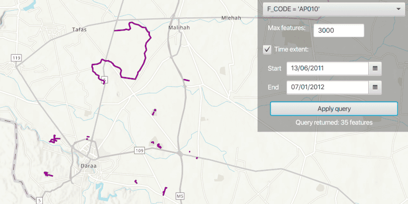
The sample loads displaying all features within the OGC API feature service. Select a sample CQL query from the drop down menu. Optionally, adjust the max features value in the text box, and toggle the time extent check box to query the data with a time extent. Press the "Apply query" button to see the query applied to the OGC API features shown on the map.
How it works
- Create an
OgcFeatureCollectionTableobject using a URL to an OGC API feature service and a collection ID. - Create
QueryParametersand set a CQL filter string to it usingqueryParameters.setWhereClause(). - Set the maximum amount of features to be returned with
queryParamters.setMaxFeatures(). - Create a new
TimeExtentfrom start and end date values, and set it to thequeryParameters.setTimeExtent()method. - Populate the OGC feature collection table using
.populateFromServiceAsync()with the customQueryParameterscreated in the previous steps. - Use
mapView.setViewpointGeometryAsync()with the OGC feature collection table extent to view the newly-queried features.
Relevant API
- OgcFeatureCollectionTable
- QueryParameters
- TimeExtent
About the data
The Daraa, Syria test data is OpenStreetMap data converted to the Topographic Data Store schema of NGA.
Additional information
See the OGC API website for more information on the OGC API family of standards. See the CQL documentation to learn more about the common query language.
Tags
browse, catalog, common query language, CQL, feature table, filter, OGC, OGC API, query, service, web
Sample Code
/*
* Copyright 2021 Esri.
*
* Licensed under the Apache License, Version 2.0 (the "License"); you may not
* use this file except in compliance with the License. You may obtain a copy of
* the License at
*
* http://www.apache.org/licenses/LICENSE-2.0
*
* Unless required by applicable law or agreed to in writing, software
* distributed under the License is distributed on an "AS IS" BASIS, WITHOUT
* WARRANTIES OR CONDITIONS OF ANY KIND, either express or implied. See the
* License for the specific language governing permissions and limitations under
* the License.
*/
package com.esri.samples.query_with_cql_filters;
import com.esri.arcgisruntime.ArcGISRuntimeEnvironment;
import com.esri.arcgisruntime.concurrent.ListenableFuture;
import com.esri.arcgisruntime.data.FeatureQueryResult;
import com.esri.arcgisruntime.data.OgcFeatureCollectionTable;
import com.esri.arcgisruntime.data.QueryParameters;
import com.esri.arcgisruntime.data.ServiceFeatureTable;
import com.esri.arcgisruntime.geometry.Envelope;
import com.esri.arcgisruntime.geometry.Geometry;
import com.esri.arcgisruntime.geometry.GeometryEngine;
import com.esri.arcgisruntime.layers.FeatureLayer;
import com.esri.arcgisruntime.loadable.LoadStatus;
import com.esri.arcgisruntime.mapping.ArcGISMap;
import com.esri.arcgisruntime.mapping.BasemapStyle;
import com.esri.arcgisruntime.mapping.TimeExtent;
import com.esri.arcgisruntime.mapping.view.MapView;
import com.esri.arcgisruntime.symbology.SimpleLineSymbol;
import com.esri.arcgisruntime.symbology.SimpleRenderer;
import javafx.collections.FXCollections;
import javafx.collections.ObservableList;
import javafx.fxml.FXML;
import javafx.scene.control.Alert;
import javafx.scene.control.Button;
import javafx.scene.control.CheckBox;
import javafx.scene.control.ComboBox;
import javafx.scene.control.DatePicker;
import javafx.scene.control.Label;
import javafx.scene.control.ListCell;
import javafx.scene.control.ProgressIndicator;
import javafx.scene.control.TextField;
import javafx.scene.paint.Color;
import java.time.LocalDate;
import java.util.ArrayList;
import java.util.Calendar;
import java.util.List;
import java.util.concurrent.ExecutionException;
public class QueryWithCqlFiltersController {
@FXML private Button applyQueryButton;
@FXML private Button revertToInitialQueryButton;
@FXML private CheckBox timeExtentCheckBox;
@FXML private ComboBox<String> comboBox;
@FXML private DatePicker endDatePicker;
@FXML private DatePicker startDatePicker;
@FXML private Label featureNumberLabel;
@FXML private MapView mapView;
@FXML private ProgressIndicator progressIndicator;
@FXML private TextField textField;
private Envelope datasetExtent;
private OgcFeatureCollectionTable ogcFeatureCollectionTable; // keep loadable in scope to avoid garbage collection
public void initialize() {
try {
// authentication with an API key or named user is required to access basemaps and other location services
String yourAPIKey = System.getProperty("apiKey");
ArcGISRuntimeEnvironment.setApiKey(yourAPIKey);
// create a map with the topographic basemap style
ArcGISMap map = new ArcGISMap(BasemapStyle.ARCGIS_TOPOGRAPHIC);
// set the map to the mapview
mapView.setMap(map);
// prepare UI for interaction
populateUiWithCqlQueriesAndDateValues();
// define strings for the service URL and collection id
// note that the service defines the collection id which can be accessed via OgcFeatureCollectionInfo.getCollectionId().
String serviceUrl = "https://demo.ldproxy.net/daraa";
String collectionId = "TransportationGroundCrv";
// create an OGC feature collection table from the service url and collection id
ogcFeatureCollectionTable = new OgcFeatureCollectionTable(serviceUrl, collectionId);
// set the feature request mode to manual
// in this mode, the table must be manually populated - panning and zooming won't request features automatically
ogcFeatureCollectionTable.setFeatureRequestMode(ServiceFeatureTable.FeatureRequestMode.MANUAL_CACHE);
// create a feature layer from the feature collection table and
var featureLayer = new FeatureLayer(ogcFeatureCollectionTable);
// add the layer to the map
map.getOperationalLayers().add(featureLayer);
// once the feature layer has loaded, set a renderer to it to visualize the OGC API features and zoom to features
featureLayer.addDoneLoadingListener(() -> {
if (featureLayer.getLoadStatus() == LoadStatus.LOADED) {
var simpleRenderer = new SimpleRenderer(new SimpleLineSymbol(SimpleLineSymbol.Style.SOLID, Color.DARKMAGENTA, 3));
featureLayer.setRenderer(simpleRenderer);
// get the extent of the dataset
datasetExtent = ogcFeatureCollectionTable.getExtent();
// display result of query on the map
setInitialQueryOnOgcFeatureTable();
} else {
// show an alert dialog if there is a loading failure
new Alert(Alert.AlertType.ERROR, "Failed to load feature layer: " +
featureLayer.getLoadError().getCause().getMessage()).show();
}
});
} catch (Exception e) {
// on any error, display the stack trace.
e.printStackTrace();
}
}
/**
* Sets the map view's viewpoint with the extent of the OGC feature collection table, and uses a basic query parameters to return 3000 features
* from the service.
*/
@FXML
private void setInitialQueryOnOgcFeatureTable() {
progressIndicator.setVisible(true);
// zoom to the dataset extent
if (datasetExtent != null && !datasetExtent.isEmpty()) {
mapView.setViewpointGeometryAsync(datasetExtent);
}
QueryParameters ogcFeatureExtentQueryParameters = new QueryParameters();
// create a query based on the current visible extent
ogcFeatureExtentQueryParameters.setGeometry(datasetExtent);
// set a limit of 3000 on the number of returned features per request, the default on some services could be as low as 10
ogcFeatureExtentQueryParameters.setMaxFeatures(3000);
try {
// populate and load the table with the query parameters
// set the clearCache parameter to true to clear existing table entries, set the outfields parameter to null to request all fields
ogcFeatureCollectionTable.populateFromServiceAsync(ogcFeatureExtentQueryParameters, true, null).addDoneListener(() -> {
progressIndicator.setVisible(false);
applyQueryButton.setDisable(false);
// display number of features returned
setFeatureNumberLabelText();
});
// handle UI
revertToInitialQueryButton.setDisable(true);
textField.setText("3000");
// reset combo box and show original prompt text
comboBox.getSelectionModel().clearSelection();
comboBox.setButtonCell(new ListCell<>() {
@Override
protected void updateItem(String item, boolean empty) {
setText(item);
}
});
} catch (Exception exception) {
exception.printStackTrace();
new Alert(Alert.AlertType.ERROR, exception.getMessage()).show();
}
}
/**
* Populates features from query parameters, and displays the result on the map.
*/
@FXML
private void query() {
QueryParameters cqlQueryParameters = new QueryParameters();
// set the query parameter's where clause with the CQL query in the combo box
cqlQueryParameters.setWhereClause(comboBox.getSelectionModel().getSelectedItem());
// set the max features to the number entered in the text field
try {
cqlQueryParameters.setMaxFeatures(Integer.parseInt(textField.getText()));
} catch (NumberFormatException e) {
new Alert(Alert.AlertType.ERROR, "Value entered must be numerical").show();
}
// if the time extent checkbox is selected, retrieve the date selected from the date picker and set it to the
// query parameters time extent
if (timeExtentCheckBox.isSelected()) {
// get the value selected from the date picker
LocalDate startDate = startDatePicker.getValue();
LocalDate endDate = endDatePicker.getValue();
// convert the value into a calendar
Calendar start = new Calendar.Builder().setDate(startDate.getYear(), startDate.getMonthValue(), startDate.getDayOfMonth()).build();
Calendar end = new Calendar.Builder().setDate(endDate.getYear(), endDate.getMonthValue(), endDate.getDayOfMonth()).build();
// set the query parameters time extent
cqlQueryParameters.setTimeExtent(new TimeExtent(start, end));
}
// populate and load the table with the query parameters
// set the clearCache parameter to true to clear existing table entries and set the outfields parameter to null to request all fields
ListenableFuture<FeatureQueryResult> result = ogcFeatureCollectionTable.populateFromServiceAsync(cqlQueryParameters, true, null);
result.addDoneListener(() -> {
// display number of features returned
setFeatureNumberLabelText();
try {
// create a new list to store returned geometries in
List<Geometry> featureGeometryList = new ArrayList<>();
// iterate through each result to get its geometry and add it to the geometry list
result.get().iterator().forEachRemaining(feature -> featureGeometryList.add(feature.getGeometry()));
if (!featureGeometryList.isEmpty()) {
// zoom to the total extent of the geometries returned by the query
var totalExtent = GeometryEngine.combineExtents(featureGeometryList);
mapView.setViewpointGeometryAsync(totalExtent, 20);
}
} catch (InterruptedException | ExecutionException e) {
e.printStackTrace();
}
revertToInitialQueryButton.setDisable(false);
});
}
/**
* Handles user interaction with the date picker to ensure the end date time is not earlier than the start date.
*/
@FXML
private void handleDatePickerInteraction() {
if (startDatePicker.getValue().toEpochDay() > endDatePicker.getValue().toEpochDay()) {
endDatePicker.setValue(startDatePicker.getValue());
}
}
/**
* Binds the enabled status of the start and end date pickers with the checkbox selected property.
*/
@FXML
private void handleCheckBoxInteraction() {
startDatePicker.disableProperty().bind(timeExtentCheckBox.selectedProperty().not());
endDatePicker.disableProperty().bind(timeExtentCheckBox.selectedProperty().not());
}
/**
* Gets the total feature count from the OGC feature collection table and displays the number on the label.
*/
private void setFeatureNumberLabelText() {
// display number of features returned
featureNumberLabel.setText("Query returned: " + ogcFeatureCollectionTable.getTotalFeatureCount() + " features");
}
/**
* Add CQL query examples relevant to the sample data to the combobox and set the date picker to dates
* relevant to the data.
*/
private void populateUiWithCqlQueriesAndDateValues() {
ObservableList<String> cqlQueryList = FXCollections.observableArrayList();
// sample query 1: query for features with an F_CODE attribute property of "AP010".
cqlQueryList.add("{ \"op\": \"=\", \"args\": [ { \"property\": \"F_CODE\" }, \"AP010\" ] }"); // cql2-json query
// sample query 2: cql-text query for features with an F_CODE attribute property similar to "AQ".
cqlQueryList.add("F_CODE LIKE 'AQ%'");
// sample query 3: use cql2-json to combine "before" and "eq" operators with the logical "and" operator
cqlQueryList.add("{\"op\": \"and\", \"args\":[{ \"op\": \"=\", \"args\":[{ \"property\" : \"F_CODE\" }, \"AP010\"]}, { \"op\": \"t_before\", \"args\":[{ \"property\" : \"ZI001_SDV\"},\"2013-01-01\"]}]}");
// add sample CQL queries to the UI combobox
comboBox.getItems().addAll(cqlQueryList);
// set the date picker to a date relevant to the data
startDatePicker.setValue(LocalDate.of(2011, 6, 13));
endDatePicker.setValue(LocalDate.of(2012, 1, 7));
}
/**
* Disposes application resources.
*/
void terminate() {
if (mapView != null) {
mapView.dispose();
}
}
}