Display local 3D point cloud data.
Use case
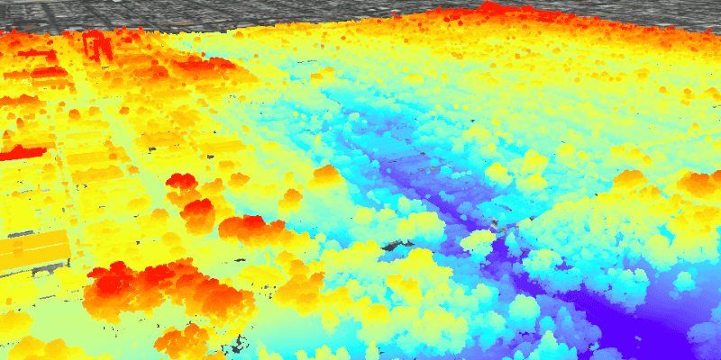
Point clouds are often used to visualize massive sets of sensor data such as lidar. The point locations indicate where the sensor data was measured spatially, and the color or size of the points indicate the measured/derived value of the sensor reading. In the case of lidar, the color of the visualized point could be the color of the reflected light, so that the point cloud forms a true color 3D image of the area.
Point clouds can be loaded offline from scene layer packages (.slpk).
How to use the sample
The sample starts with a point cloud layer loaded and draped on top of a scene. Pan and zoom to explore the scene and see the detail of the point cloud layer.
How it works
- Create a
PointCloudLayerwith the path to a local .slpk file containing a point cloud layer. - Add the layer to a scene's operational layers collection with
getOperationalLayers().add(pointCloudLayer).
Relevant API
- PointCloudLayer
About the data
This point cloud data comes from Balboa Park in San Diego, California. Created and provided by USGS.
Tags
3D, lidar, point cloud
Sample Code
/*
* Copyright 2019 Esri.
*
* Licensed under the Apache License, Version 2.0 (the "License"); you may not
* use this file except in compliance with the License. You may obtain a copy of
* the License at
*
* http://www.apache.org/licenses/LICENSE-2.0
*
* Unless required by applicable law or agreed to in writing, software
* distributed under the License is distributed on an "AS IS" BASIS, WITHOUT
* WARRANTIES OR CONDITIONS OF ANY KIND, either express or implied. See the
* License for the specific language governing permissions and limitations under
* the License.
*/
package com.esri.samples.view_point_cloud_data_offline;
import java.io.File;
import javafx.application.Application;
import javafx.scene.Scene;
import javafx.scene.control.Alert;
import javafx.scene.layout.StackPane;
import javafx.stage.Stage;
import com.esri.arcgisruntime.ArcGISRuntimeEnvironment;
import com.esri.arcgisruntime.layers.PointCloudLayer;
import com.esri.arcgisruntime.loadable.LoadStatus;
import com.esri.arcgisruntime.mapping.ArcGISScene;
import com.esri.arcgisruntime.mapping.ArcGISTiledElevationSource;
import com.esri.arcgisruntime.mapping.BasemapStyle;
import com.esri.arcgisruntime.mapping.Surface;
import com.esri.arcgisruntime.mapping.view.Camera;
import com.esri.arcgisruntime.mapping.view.SceneView;
public class ViewPointCloudDataOfflineSample extends Application {
private SceneView sceneView;
@Override
public void start(Stage stage) {
try {
// set the title and size of the stage and show it
stage.setTitle("View Point Cloud Data Offline Sample");
stage.setWidth(800);
stage.setHeight(700);
// create a JavaFX scene with a stackpane and set it to the stage
StackPane stackPane = new StackPane();
Scene fxScene = new Scene(stackPane);
stage.setScene(fxScene);
stage.show();
// authentication with an API key or named user is required to access basemaps and other location services
String yourAPIKey = System.getProperty("apiKey");
ArcGISRuntimeEnvironment.setApiKey(yourAPIKey);
// create a scene view and add it to the stack pane
sceneView = new SceneView();
stackPane.getChildren().add(sceneView);
// create a scene with a basemap style and add it to the scene view
ArcGISScene scene = new ArcGISScene(BasemapStyle.ARCGIS_IMAGERY);
sceneView.setArcGISScene(scene);
// set the base surface with world elevation
Surface surface = new Surface();
surface.getElevationSources().add(new ArcGISTiledElevationSource("https://elevation3d.arcgis.com/arcgis/rest/services/WorldElevation3D/Terrain3D/ImageServer"));
scene.setBaseSurface(surface);
// add a point cloud layer from a scene layer package of Balboa Park in San Diego
File pointCloudSLPK = new File(System.getProperty("data.dir"), "./samples-data/slpks/sandiego-north-balboa-pointcloud.slpk");
PointCloudLayer pointCloudLayer = new PointCloudLayer(pointCloudSLPK.getAbsolutePath());
scene.getOperationalLayers().add(pointCloudLayer);
// zoom to the layer when it is done loading
pointCloudLayer.addDoneLoadingListener(() -> {
if (pointCloudLayer.getLoadStatus() == LoadStatus.LOADED) {
sceneView.setViewpointCamera(new Camera(pointCloudLayer.getFullExtent().getCenter(), 2000, 30, 60, 0));
} else {
new Alert(Alert.AlertType.ERROR, "Point cloud layer failed to load").show();
}
});
} catch (Exception e) {
// on any error, display the stack trace.
e.printStackTrace();
}
}
/**
* Stops and releases all resources used in application.
*/
@Override
public void stop() {
if (sceneView != null) {
sceneView.dispose();
}
}
/**
* Opens and runs application.
*
* @param args arguments passed to this application
*/
public static void main(String[] args) {
Application.launch(args);
}
}