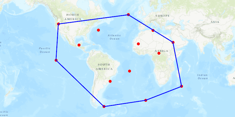
Create a convex hull for a given set of points. The convex hull is a polygon with shortest perimeter that encloses a set of points. As a visual analogy, consider a set of points as nails in a board. The convex hull of the points would be like a rubber band stretched around the outermost nails.
Use case
A convex hull can be useful in collision detection. For example, when charting the position of two yacht fleets (with each vessel represented by a point), if their convex hulls have been precomputed, it is efficient to first check if their convex hulls intersect before computing their proximity point-by-point.
How to use the sample
Click on the map to add points. Click the "Create Convex Hull" button to generate the convex hull of those points. Click the "Clear" button to start over.
How it works
- Create an input geometry such as a
Multipointobject. - Use
GeometryEngine.convexHull(inputGeometry)to create a newGeometryobject representing the convex hull of the input points. The returned geometry will either be aPoint,Polyline, orPolygonbased on the number of input points.
Relevant API
- Geometry
- GeometryEngine
Tags
convex hull, geometry, spatial analysis
Sample Code
/*
* Copyright 2018 Esri.
*
* Licensed under the Apache License, Version 2.0 (the "License"); you may not
* use this file except in compliance with the License. You may obtain a copy of
* the License at
*
* http://www.apache.org/licenses/LICENSE-2.0
*
* Unless required by applicable law or agreed to in writing, software
* distributed under the License is distributed on an "AS IS" BASIS, WITHOUT
* WARRANTIES OR CONDITIONS OF ANY KIND, either express or implied. See the
* License for the specific language governing permissions and limitations under
* the License.
*/
package com.esri.samples.convex_hull;
import java.util.ArrayList;
import java.util.List;
import javafx.application.Application;
import javafx.geometry.Insets;
import javafx.geometry.Point2D;
import javafx.geometry.Pos;
import javafx.scene.Scene;
import javafx.scene.control.Button;
import javafx.scene.input.MouseButton;
import javafx.scene.layout.Background;
import javafx.scene.layout.BackgroundFill;
import javafx.scene.layout.CornerRadii;
import javafx.scene.layout.StackPane;
import javafx.scene.layout.VBox;
import javafx.scene.paint.Color;
import javafx.scene.paint.Paint;
import javafx.stage.Stage;
import com.esri.arcgisruntime.ArcGISRuntimeEnvironment;
import com.esri.arcgisruntime.geometry.Geometry;
import com.esri.arcgisruntime.geometry.GeometryEngine;
import com.esri.arcgisruntime.geometry.Multipoint;
import com.esri.arcgisruntime.geometry.Point;
import com.esri.arcgisruntime.geometry.PointCollection;
import com.esri.arcgisruntime.mapping.ArcGISMap;
import com.esri.arcgisruntime.mapping.BasemapStyle;
import com.esri.arcgisruntime.mapping.view.Graphic;
import com.esri.arcgisruntime.mapping.view.GraphicsOverlay;
import com.esri.arcgisruntime.mapping.view.MapView;
import com.esri.arcgisruntime.symbology.SimpleLineSymbol;
import com.esri.arcgisruntime.symbology.SimpleMarkerSymbol;
public class ConvexHullSample extends Application {
private MapView mapView;
@Override
public void start(Stage stage) {
try {
// create stack pane and application scene
StackPane stackPane = new StackPane();
Scene scene = new Scene(stackPane);
// set title, size, and add scene to stage
stage.setTitle("Convex Hull Sample");
stage.setWidth(800);
stage.setHeight(700);
stage.setScene(scene);
stage.show();
// authentication with an API key or named user is required to access basemaps and other location services
String yourAPIKey = System.getProperty("apiKey");
ArcGISRuntimeEnvironment.setApiKey(yourAPIKey);
// create a map with the topographic basemap style
ArcGISMap map = new ArcGISMap(BasemapStyle.ARCGIS_TOPOGRAPHIC);
// create a map view and set the map to it
mapView = new MapView();
mapView.setMap(map);
// create a graphics overlay to show the input points and convex hull
var graphicsOverlay = new GraphicsOverlay();
mapView.getGraphicsOverlays().add(graphicsOverlay);
// create a graphic to show the points
var simpleMarkerSymbol = new SimpleMarkerSymbol(SimpleMarkerSymbol.Style.CIRCLE, Color.RED, 10);
Graphic inputsGraphic = new Graphic();
inputsGraphic.setSymbol(simpleMarkerSymbol);
graphicsOverlay.getGraphics().add(inputsGraphic);
// create a graphic to show the convex hull as a blue outline
var simpleLineSymbol = new SimpleLineSymbol(SimpleLineSymbol.Style.SOLID, Color.BLUE, 3);
Graphic convexHullGraphic = new Graphic();
graphicsOverlay.getGraphics().add(convexHullGraphic);
// keep track of the points added by the user
List<Point> inputs = new ArrayList<>();
// create a button to create and show the convex hull
var convexHullButton = new Button("Create Convex Hull");
convexHullButton.setMaxWidth(130);
convexHullButton.setDisable(true);
convexHullButton.setOnAction(e -> {
convexHullButton.setDisable(true);
// change the symbol depending on the returned geometry type
Geometry convexHull = GeometryEngine.convexHull(inputsGraphic.getGeometry());
switch (convexHull.getGeometryType()) {
case POINT:
convexHullGraphic.setSymbol(simpleMarkerSymbol);
break;
case POLYLINE:
case POLYGON:
convexHullGraphic.setSymbol(simpleLineSymbol);
break;
}
convexHullGraphic.setGeometry(convexHull);
});
// create a button to clear all graphics
var clearButton = new Button("Clear");
clearButton.setMaxWidth(130);
clearButton.setDisable(true);
clearButton.setOnAction(e -> {
inputs.clear();
inputsGraphic.setGeometry(null);
convexHullGraphic.setGeometry(null);
convexHullButton.setDisable(true);
clearButton.setDisable(true);
});
var vBox = new VBox(6);
vBox.setPickOnBounds(false);
vBox.setBackground(new Background(new BackgroundFill(Paint.valueOf("rgba(0,0,0,0.3)"), CornerRadii.EMPTY, Insets.EMPTY)));
vBox.setPadding(new Insets(10.0));
vBox.setMaxSize(150, 50);
vBox.getStyleClass().add("panel-region");
vBox.getChildren().addAll(convexHullButton, clearButton);
// create a point from where the user clicked
mapView.setOnMouseClicked(e -> {
if (e.isStillSincePress() && e.getButton() == MouseButton.PRIMARY) {
Point2D point = new Point2D(e.getX(), e.getY());
// create a map point from a point
Point mapPoint = mapView.screenToLocation(point);
// the map point should be normalized to the central meridian when wrapping around a map, so its value stays within the coordinate system of the map view
Point normalizedMapPoint = (Point) GeometryEngine.normalizeCentralMeridian(mapPoint);
// add a point where the user clicks on the map
inputs.add(normalizedMapPoint);
// update the inputs graphic geometry
Multipoint inputsGeometry = new Multipoint(new PointCollection(inputs));
inputsGraphic.setGeometry(inputsGeometry);
// if a new point is added, enable the convex hull and clear buttons
if (inputs.size() > 0) {
convexHullButton.setDisable(false);
clearButton.setDisable(false);
}
}
});
// add the map view to the stack pane
stackPane.getChildren().addAll(mapView, vBox);
StackPane.setAlignment(vBox, Pos.TOP_LEFT);
StackPane.setMargin(vBox, new Insets(10, 0, 0, 10));
} catch (Exception e) {
// on any error, display the stack trace.
e.printStackTrace();
}
}
/**
* Stops and releases all resources used in application.
*/
@Override
public void stop() {
if (mapView != null) {
mapView.dispose();
}
}
/**
* Opens and runs application.
*
* @param args arguments passed to this application
*/
public static void main(String[] args) {
Application.launch(args);
}
}