Display a layer from a WFS service, requesting only features for the current extent.
Use case
WFS is an open standard with functionality similar to ArcGIS feature services. The ArcGIS Maps SDKs for Native Apps support for WFS allows you to interoperate with open systems, which are often used in inter-agency efforts, like those for disaster relief.
How to use the sample
Pan and zoom to see features within the current map extent.
How it works
- Create a
WfsFeatureTablewith a URL. - Create a
FeatureLayerfrom the feature table and add it to the map. - Add a
NavigationChangedListenerto the map view to listen for aNavigationChangedEvent. Check if it!isNavigating()to detect when the user has stopped navigating the map. - When the user is finished navigating, use
populateFromServiceAsync(...)to load the table with data for the current visible extent.
Relevant API
- FeatureLayer
- NavigationChangedEvent
- QueryParameters
- WfsFeatureTable
About the data
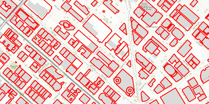
This service shows building footprints for downtown Seattle. For additional information, see the underlying service on ArcGIS Online.
Tags
browse, catalog, feature, interaction cache, layers, OGC, service, web, WFS
Sample Code
DisplayWFSLayerSample.java
/*
* Copyright 2019 Esri.
*
* Licensed under the Apache License, Version 2.0 (the "License"); you may not
* use this file except in compliance with the License. You may obtain a copy of
* the License at
*
* http://www.apache.org/licenses/LICENSE-2.0
*
* Unless required by applicable law or agreed to in writing, software
* distributed under the License is distributed on an "AS IS" BASIS, WITHOUT
* WARRANTIES OR CONDITIONS OF ANY KIND, either express or implied. See the
* License for the specific language governing permissions and limitations under
* the License.
*/
package com.esri.samples.display_wfs_layer;
import javafx.application.Application;
import javafx.scene.Scene;
import javafx.scene.layout.StackPane;
import javafx.scene.paint.Color;
import javafx.stage.Stage;
import com.esri.arcgisruntime.ArcGISRuntimeEnvironment;
import com.esri.arcgisruntime.data.QueryParameters;
import com.esri.arcgisruntime.data.ServiceFeatureTable;
import com.esri.arcgisruntime.geometry.Envelope;
import com.esri.arcgisruntime.geometry.Point;
import com.esri.arcgisruntime.layers.FeatureLayer;
import com.esri.arcgisruntime.mapping.ArcGISMap;
import com.esri.arcgisruntime.mapping.BasemapStyle;
import com.esri.arcgisruntime.mapping.Viewpoint;
import com.esri.arcgisruntime.mapping.view.MapView;
import com.esri.arcgisruntime.ogc.wfs.WfsFeatureTable;
import com.esri.arcgisruntime.symbology.SimpleLineSymbol;
import com.esri.arcgisruntime.symbology.SimpleRenderer;
public class DisplayWFSLayerSample extends Application {
private MapView mapView;
@Override
public void start(Stage stage) {
// create stack pane and JavaFX app scene
StackPane stackPane = new StackPane();
Scene scene = new Scene(stackPane);
// set title, size, and add JavaFX scene to stage
stage.setTitle("Display a WFS Layer");
stage.setWidth(800);
stage.setHeight(700);
stage.setScene(scene);
stage.show();
// authentication with an API key or named user is required to access basemaps and other location services
String yourAPIKey = System.getProperty("apiKey");
ArcGISRuntimeEnvironment.setApiKey(yourAPIKey);
// create a map with the topographic basemap style
ArcGISMap map = new ArcGISMap(BasemapStyle.ARCGIS_TOPOGRAPHIC);
// create a map view and set the map to it
mapView = new MapView();
mapView.setMap(map);
// create an initial extent to load
Point topLeft = new Point(-13619002.499764, 6043406.351867);
Point bottomRight = new Point(-13618454.919189, 6042836.793464);
Envelope initialExtent = new Envelope(topLeft, bottomRight);
mapView.setViewpoint(new Viewpoint(initialExtent));
String serviceUrl = "https://dservices2.arcgis.com/ZQgQTuoyBrtmoGdP/arcgis/services/Seattle_Downtown_Features/WFSServer?service=wfs&request=getcapabilities";
String LayerName = "Seattle_Downtown_Features:Buildings";
// create a FeatureTable from the WFS service URL and name of the layer
WfsFeatureTable wfsFeatureTable = new WfsFeatureTable(serviceUrl, LayerName);
// set the feature request mode to manual. The table must be manually populated as panning and zooming won't request features automatically.
wfsFeatureTable.setFeatureRequestMode(ServiceFeatureTable.FeatureRequestMode.MANUAL_CACHE);
// create a feature layer to visualize the WFS features
FeatureLayer wfsFeatureLayer = new FeatureLayer(wfsFeatureTable);
// apply a renderer to the feature layer
SimpleRenderer renderer = new SimpleRenderer(new SimpleLineSymbol(SimpleLineSymbol.Style.SOLID, Color.RED, 3));
wfsFeatureLayer.setRenderer(renderer);
// add the layer to the map's operational layers
map.getOperationalLayers().add(wfsFeatureLayer);
// make an initial call to load the initial extent's data from the WFS, using the WFS spatial reference
populateFeaturesFromServer(wfsFeatureTable, initialExtent);
// use the navigation property listener to populate the table with the features needed for the current extent
mapView.navigatingProperty().addListener((observable, oldValue, newValue) -> {
// once the map view has stopped navigating
if (!newValue) {
populateFeaturesFromServer(wfsFeatureTable, mapView.getVisibleArea().getExtent());
}
});
// add the mapview to the stackpane
stackPane.getChildren().add(mapView);
}
/**
* Create query parameters using the given extent to populate the WFS table from the service
* @param wfsTable the WFS feature table to populate
* @param extent the extent used to define the QueryParameters' geometry
*/
private void populateFeaturesFromServer(WfsFeatureTable wfsTable, Envelope extent){
// create a query based on the current visible extent
QueryParameters visibleExtentQuery = new QueryParameters();
visibleExtentQuery.setGeometry(extent);
visibleExtentQuery.setSpatialRelationship(QueryParameters.SpatialRelationship.INTERSECTS);
// populate the WFS feature table based on the current extent
wfsTable.populateFromServiceAsync(visibleExtentQuery, false, null);
}
/**
* Stops and releases all resources used in application.
*/
@Override
public void stop() {
if (mapView != null) {
mapView.dispose();
}
}
/**
* Opens and runs application.
*
* @param args arguments passed to this application
*/
public static void main(String[] args) {
Application.launch(args);
}
}