Change a graphic's symbol based on the camera's proximity to it.
Use case
When showing dense datasets, it is beneficial to reduce the detail of individual points when zooming out to avoid visual clutter and to avoid data points overlapping and obscuring each other.
How to use the sample
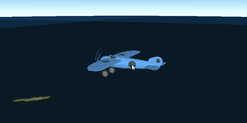
The sample starts looking at a plane. Zoom out from the plane to see it turn into a cone. Keeping zooming out and it will turn into a point.
How it works
- Create a
GraphicsOverlayobject and add it to aSceneViewobject. - Create a
DistanceCompositeSceneSymbolobject. - Create
DistanceCompositeSceneSymbol.Rangeobjects specifying aSymboland the min and max distance within which the symbol should be visible. - Add the ranges to the range collection of the distance composite scene symbol.
- Create a
Graphicobject with the distance composite scene symbol at a location and add it to the graphics overlay.
Relevant API
- DistanceCompositeSceneSymbol
- DistanceCompositeSceneSymbol.Range
Tags
3D, data, graphic
Sample Code
DistanceCompositeSymbolSample.java
/*
* Copyright 2017 Esri.
*
* Licensed under the Apache License, Version 2.0 (the "License"); you may not
* use this file except in compliance with the License. You may obtain a copy of
* the License at
*
* http://www.apache.org/licenses/LICENSE-2.0
*
* Unless required by applicable law or agreed to in writing, software
* distributed under the License is distributed on an "AS IS" BASIS, WITHOUT
* WARRANTIES OR CONDITIONS OF ANY KIND, either express or implied. See the
* License for the specific language governing permissions and limitations under
* the License.
*/
package com.esri.samples.distance_composite_symbol;
import javafx.application.Application;
import javafx.scene.Scene;
import javafx.scene.layout.StackPane;
import javafx.scene.paint.Color;
import javafx.stage.Stage;
import com.esri.arcgisruntime.ArcGISRuntimeEnvironment;
import com.esri.arcgisruntime.geometry.Point;
import com.esri.arcgisruntime.geometry.SpatialReferences;
import com.esri.arcgisruntime.mapping.ArcGISScene;
import com.esri.arcgisruntime.mapping.ArcGISTiledElevationSource;
import com.esri.arcgisruntime.mapping.BasemapStyle;
import com.esri.arcgisruntime.mapping.Surface;
import com.esri.arcgisruntime.mapping.view.Graphic;
import com.esri.arcgisruntime.mapping.view.GraphicsOverlay;
import com.esri.arcgisruntime.mapping.view.LayerSceneProperties;
import com.esri.arcgisruntime.mapping.view.OrbitGeoElementCameraController;
import com.esri.arcgisruntime.mapping.view.SceneView;
import com.esri.arcgisruntime.symbology.DistanceCompositeSceneSymbol;
import com.esri.arcgisruntime.symbology.ModelSceneSymbol;
import com.esri.arcgisruntime.symbology.SceneSymbol.AnchorPosition;
import com.esri.arcgisruntime.symbology.SimpleMarkerSceneSymbol;
import com.esri.arcgisruntime.symbology.SimpleMarkerSymbol;
import java.io.File;
public class DistanceCompositeSymbolSample extends Application {
private SceneView sceneView;
private static final String ELEVATION_IMAGE_SERVICE =
"https://elevation3d.arcgis.com/arcgis/rest/services/WorldElevation3D/Terrain3D/ImageServer";
@Override
public void start(Stage stage) {
try {
// create stack pane and JavaFX app scene
StackPane stackPane = new StackPane();
Scene fxScene = new Scene(stackPane);
// set title, size, and add JavaFX scene to stage
stage.setTitle("Distance Composite Symbol Sample");
stage.setWidth(800);
stage.setHeight(700);
stage.setScene(fxScene);
stage.show();
// authentication with an API key or named user is required to access basemaps and other location services
String yourAPIKey = System.getProperty("apiKey");
ArcGISRuntimeEnvironment.setApiKey(yourAPIKey);
// create a scene with a basemap style
ArcGISScene scene = new ArcGISScene(BasemapStyle.ARCGIS_IMAGERY);
// add the SceneView to the stack pane
sceneView = new SceneView();
sceneView.setArcGISScene(scene);
stackPane.getChildren().addAll(sceneView);
// add base surface for elevation data
Surface surface = new Surface();
surface.getElevationSources().add(new ArcGISTiledElevationSource(ELEVATION_IMAGE_SERVICE));
scene.setBaseSurface(surface);
// add a graphics overlay
GraphicsOverlay graphicsOverlay = new GraphicsOverlay();
graphicsOverlay.getSceneProperties().setSurfacePlacement(LayerSceneProperties.SurfacePlacement.RELATIVE);
sceneView.getGraphicsOverlays().add(graphicsOverlay);
// set up the different symbols
SimpleMarkerSymbol circleSymbol = new SimpleMarkerSymbol(SimpleMarkerSymbol.Style.CIRCLE, Color.RED, 10);
SimpleMarkerSceneSymbol coneSymbol = SimpleMarkerSceneSymbol.createCone(Color.RED, 3, 10);
coneSymbol.setPitch(-90);
coneSymbol.setAnchorPosition(AnchorPosition.CENTER);
String modelURI = new File(System.getProperty("data.dir"), "./samples-data/bristol/Collada/Bristol.dae").getAbsolutePath();
ModelSceneSymbol modelSymbol = new ModelSceneSymbol(modelURI, 1.0);
modelSymbol.loadAsync();
// set up the distance composite symbol
DistanceCompositeSceneSymbol compositeSymbol = new DistanceCompositeSceneSymbol();
compositeSymbol.getRangeCollection().add(new DistanceCompositeSceneSymbol.Range(modelSymbol, 0, 100));
compositeSymbol.getRangeCollection().add(new DistanceCompositeSceneSymbol.Range(coneSymbol, 100, 500));
compositeSymbol.getRangeCollection().add(new DistanceCompositeSceneSymbol.Range(circleSymbol, 500, 0));
// create graphic
Point aircraftPosition = new Point(-2.708471, 56.096575, 5000, SpatialReferences.getWgs84());
Graphic aircraftGraphic = new Graphic(aircraftPosition, compositeSymbol);
// add graphic to graphics overlay
graphicsOverlay.getGraphics().add(aircraftGraphic);
// add an orbit camera controller to lock the camera to the graphic
OrbitGeoElementCameraController cameraController = new OrbitGeoElementCameraController(aircraftGraphic, 20);
cameraController.setCameraPitchOffset(80);
cameraController.setCameraHeadingOffset(-30);
sceneView.setCameraController(cameraController);
} catch (Exception e) {
// on any error, display the stack trace.
e.printStackTrace();
}
}
/**
* Stops and releases all resources used in application.
*/
@Override
public void stop() {
if (sceneView != null) {
sceneView.dispose();
}
}
/**
* Opens and runs application.
*
* @param args arguments passed to this application
*/
public static void main(String[] args) {
Application.launch(args);
}
}