Identify features in all layers in a map.
Use case
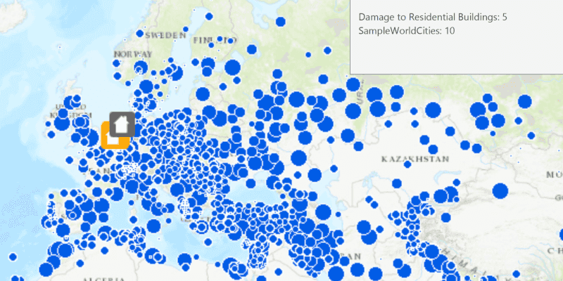
Identify layers allows users to return features on a map at a specified location across multiple layers. Because some layer types have sublayers, the sample recursively counts results for sublayers within each layer.
How to use the sample
Click to identify features. An alert will show all layers with features under the clicked location, as well as the number of features.
How it works
- The clicked map point is passed to
MapView.identifyLayersAsync - For each
IdentifyLayerResultin the results, features are counted.- Note: there is one identify result per layer with matching features; if the feature count is 0, that means a sublayer contains the matching features.
Relevant API
- IdentifyLayerResult
- MapView
Additional information
The GeoView supports two methods of identify: identifyLayerAsync(), which identifies features within a specific layer and identifyLayersAsync(), which identifies features for all layers in the current view.
Tags
identify, recursion, recursive, sublayers
Sample Code
IdentifyLayersSample.java
/*
* Copyright 2018 Esri.
*
* Licensed under the Apache License, Version 2.0 (the "License"); you may not
* use this file except in compliance with the License. You may obtain a copy of
* the License at
*
* http://www.apache.org/licenses/LICENSE-2.0
*
* Unless required by applicable law or agreed to in writing, software
* distributed under the License is distributed on an "AS IS" BASIS, WITHOUT
* WARRANTIES OR CONDITIONS OF ANY KIND, either express or implied. See the
* License for the specific language governing permissions and limitations under
* the License.
*/
package com.esri.samples.identify_layers;
import java.util.List;
import java.util.concurrent.ExecutionException;
import com.esri.arcgisruntime.ArcGISRuntimeEnvironment;
import com.esri.arcgisruntime.concurrent.ListenableFuture;
import com.esri.arcgisruntime.data.FeatureTable;
import com.esri.arcgisruntime.data.ServiceFeatureTable;
import com.esri.arcgisruntime.layers.ArcGISMapImageLayer;
import com.esri.arcgisruntime.layers.FeatureLayer;
import com.esri.arcgisruntime.loadable.LoadStatus;
import com.esri.arcgisruntime.mapping.ArcGISMap;
import com.esri.arcgisruntime.mapping.BasemapStyle;
import com.esri.arcgisruntime.mapping.Viewpoint;
import com.esri.arcgisruntime.mapping.view.IdentifyLayerResult;
import com.esri.arcgisruntime.mapping.view.MapView;
import javafx.application.Application;
import javafx.geometry.Point2D;
import javafx.scene.Scene;
import javafx.scene.control.Alert;
import javafx.scene.input.MouseButton;
import javafx.scene.layout.StackPane;
import javafx.stage.Stage;
public class IdentifyLayersSample extends Application {
private MapView mapView;
// keep loadables in scope to avoid garbage collection
private ArcGISMapImageLayer mapImageLayer;
private FeatureLayer featureLayer;
/**
* Opens and runs application.
*
* @param args arguments passed to this application
*/
public static void main(String[] args) {
Application.launch(args);
}
@Override
public void start(Stage stage) {
try {
// create stack pane and application scene
StackPane stackPane = new StackPane();
Scene scene = new Scene(stackPane);
// set title, size, and add scene to stage
stage.setTitle("Identify Layers Sample");
stage.setWidth(800);
stage.setHeight(700);
stage.setScene(scene);
stage.show();
// authentication with an API key or named user is required to access basemaps and other location services
String yourAPIKey = System.getProperty("apiKey");
ArcGISRuntimeEnvironment.setApiKey(yourAPIKey);
// create a map with the topographic basemap style
ArcGISMap map = new ArcGISMap(BasemapStyle.ARCGIS_TOPOGRAPHIC);
// create a map view and set the map to it
mapView = new MapView();
mapView.setMap(map);
// set a viewpoint on the map view
mapView.setViewpoint(new Viewpoint(40.26684, -100.98579, 68015210));
// add a map image layer with one sublayer visible
mapImageLayer = new ArcGISMapImageLayer("https://sampleserver6.arcgisonline.com/arcgis/rest/services/SampleWorldCities/MapServer");
mapImageLayer.addDoneLoadingListener(() -> {
if (mapImageLayer.getLoadStatus() == LoadStatus.LOADED) {
// hide Continent and World layers
mapImageLayer.getSubLayerContents().get(1).setVisible(false);
mapImageLayer.getSubLayerContents().get(2).setVisible(false);
} else {
new Alert(Alert.AlertType.ERROR, "Failed to load the map image layer").show();
}
});
map.getOperationalLayers().add(mapImageLayer);
// add a feature layer to the map's operational layers
FeatureTable featureTable = new ServiceFeatureTable("https://sampleserver6.arcgisonline.com/arcgis/rest/services/DamageAssessment/FeatureServer/0");
featureLayer = new FeatureLayer(featureTable);
featureLayer.addDoneLoadingListener(() -> {
if (mapImageLayer.getLoadStatus() != LoadStatus.LOADED) {
new Alert(Alert.AlertType.ERROR, "Failed to load the feature layer").show();
}
});
map.getOperationalLayers().add(featureLayer);
// create map view click listener
mapView.setOnMouseClicked(e -> {
if (e.isStillSincePress() && e.getButton() == MouseButton.PRIMARY) {
// identify layers with GeoElements where the user clicked
Point2D point2D = new Point2D(e.getX(), e.getY());
ListenableFuture<List<IdentifyLayerResult>> identifyResults = mapView.identifyLayersAsync(point2D, 12, false, 10);
identifyResults.addDoneListener(() -> {
try {
// build a string with the total count of identified GeoElements for each layer
StringBuilder resultsList = new StringBuilder();
List<IdentifyLayerResult> results = identifyResults.get();
// for each result layer, recursively search its sublayers to get the total count of GeoElements
for (IdentifyLayerResult result : results) {
int recursiveGeoElementCount = searchGeoElements(result);
resultsList.append(result.getLayerContent().getName()).append(": ").append(recursiveGeoElementCount).append("\n");
}
// show the result counts string in a dialog
String resultString = resultsList.toString();
Alert alert = new Alert(Alert.AlertType.INFORMATION, resultString.equals("") ? "No Results" : resultString);
alert.initOwner(mapView.getScene().getWindow());
alert.show();
} catch (InterruptedException | ExecutionException ex) {
new Alert(Alert.AlertType.ERROR, "Failed to identify layers").show();
}
});
}
});
// add the map view to stack pane
stackPane.getChildren().add(mapView);
} catch (Exception e) {
// on any error, display the stack trace.
e.printStackTrace();
}
}
/**
* Searches an identify layer result recursively to find the identified GeoElements for all identified sublayers.
*
* @param layerResult identify layer result
* @return recursive identified GeoElements count
*/
private int searchGeoElements(IdentifyLayerResult layerResult) {
int identifiedSubLayerGeoElements = 0;
for (IdentifyLayerResult subLayerResult : layerResult.getSublayerResults()) {
identifiedSubLayerGeoElements += searchGeoElements(subLayerResult);
}
return layerResult.getElements().size() + identifiedSubLayerGeoElements;
}
/**
* Stops and releases all resources used in application.
*/
@Override
public void stop() {
if (mapView != null) {
mapView.dispose();
}
}
}