Access a web map service that is secured with ArcGIS token-based authentication.
Use case
Allows you to access a secure service with the convenience and security of ArcGIS token-based authentication. For example, rather than providing a user name and password every time you want to access a secure service, you only provide those credentials initially to obtain a token which then can be used to access secured resources.
How to use the sample
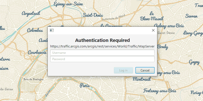
Once you launch the sample, you will be challenged for an ArcGIS Online login to view the protected map service. Enter a user name and password for an ArcGIS Online named user account (such as your ArcGIS for Developers account). If you authenticate successfully, the protected map service will display in the map.
How it works
- Create an
AuthenticationChallengeHandlerusing theDefaultAuthenticationChallengeHandlerto handle the challenges sent by the protected map service. - Set the
AuthenticationChallengeHandlerto theAuthenticationManager. - Create a
Portal. - Create a
PortalItemfor the protected web map using thePortaland Item ID of the protected map service. - Create a map to display in the
MapViewusing thePortalItem. - Set the map to display in the
MapView.
Relevant API
- ArcGISMap
- AuthenticationChallengeHandler
- AuthenticationManager
- DefaultAuthenticationChallengeHandler
- MapView
- Portal
- PortalItem
About the data
The Traffic web map uses public layers as well as the world traffic (premium content) layer. The world traffic service presents historical and near real-time traffic information for different regions in the world. The data is updated every 5 minutes. This map service requires an ArcGIS Online organizational subscription.
Additional information
Please note: the username and password are case sensitive for token-based authentication. If the user doesn't have permission to access all the content within the portal item, partial or no content will be returned.
Tags
authentication, cloud, portal, remember, security
Sample Code
/*
* Copyright 2019 Esri
*
* Licensed under the Apache License, Version 2.0 (the "License");
* you may not use this file except in compliance with the License.
* You may obtain a copy of the License at
*
* http://www.apache.org/licenses/LICENSE-2.0
*
* Unless required by applicable law or agreed to in writing, software
* distributed under the License is distributed on an "AS IS" BASIS,
* WITHOUT WARRANTIES OR CONDITIONS OF ANY KIND, either express or implied.
* See the License for the specific language governing permissions and
* limitations under the License.
*/
package com.esri.samples.token_authentication;
import javafx.application.Application;
import javafx.scene.Scene;
import javafx.scene.layout.StackPane;
import javafx.stage.Stage;
import com.esri.arcgisruntime.mapping.ArcGISMap;
import com.esri.arcgisruntime.mapping.view.MapView;
import com.esri.arcgisruntime.portal.Portal;
import com.esri.arcgisruntime.portal.PortalItem;
import com.esri.arcgisruntime.security.AuthenticationChallengeHandler;
import com.esri.arcgisruntime.security.AuthenticationManager;
import com.esri.arcgisruntime.security.DefaultAuthenticationChallengeHandler;
public class TokenAuthenticationSample extends Application {
private MapView mapView;
@Override
public void start(Stage stage) {
try {
// create stack pane and application scene
StackPane stackPane = new StackPane();
Scene scene = new Scene(stackPane);
// set title, size, and add scene to stage
stage.setTitle("Token Authentication Sample");
stage.setWidth(800);
stage.setHeight(700);
stage.setScene(scene);
stage.show();
// set up an authentication handler to take credentials for access to the protected map service
AuthenticationChallengeHandler authenticationChallengeHandler = new DefaultAuthenticationChallengeHandler();
AuthenticationManager.setAuthenticationChallengeHandler(authenticationChallengeHandler);
// create a portal to ArcGIS Online
Portal portal = new Portal("https://www.arcgis.com/");
// create a portal item using the portal and the item id of a protected map service
PortalItem portalItem = new PortalItem(portal, "e5039444ef3c48b8a8fdc9227f9be7c1");
// create a map with the portal item
ArcGISMap map = new ArcGISMap(portalItem);
// set the map to be displayed in the map view
mapView = new MapView();
mapView.setMap(map);
// add the map view to stack pane
stackPane.getChildren().add(mapView);
} catch (Exception e) {
// on any error, display the stack trace.
e.printStackTrace();
}
}
/**
* Stops and releases all resources used in application.
*/
@Override
public void stop() {
if (mapView != null) {
mapView.dispose();
}
}
/**
* Opens and runs application.
*
* @param args arguments passed to this application
*/
public static void main(String[] args) {
Application.launch(args);
}
}