Export tiles from an online vector tile service.
Use case
Field workers with limited network connectivity can use exported vector tiles as a basemap for use while offline.
How to use the sample
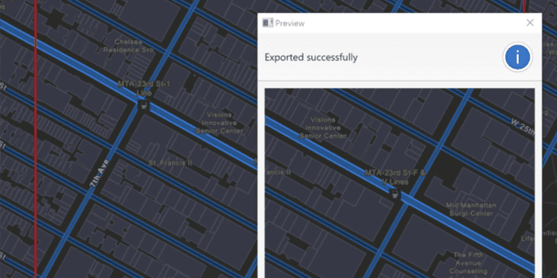
When the vector tiled layer loads, zoom in to the extent you want to export. The red box shows the extent that will be exported. Click the "Export Vector Tiles" button to start the job. An error will show if the extent is larger than the maximum limit allowed. When finished, a dialog will show the exported result in a new map view.
How it works
- Create an
ExportVectorTilesTask, passing in the URI of the vector tiled layer. - Create default
ExportVectorTilesParametersfrom the task, specifying extent and maximum scale. - Create a
ExportVectorTilesJobfrom the task using the parameters, and specifying a vector tile cache path and an item resource path. The resource path is required if you want to export the tiles with the style. - Start the job, and once it completes successfully, get the resulting
ExportVectorTilesResult. - Get the
VectorTileCacheandItemResourceCachefrom the result to create anArcGISVectorTiledLayerthat can be displayed to the map view.
Relevant API
- ArcGISVectorTiledLayer
- ExportVectorTilesJob
- ExportVectorTilesParameters
- ExportVectorTilesResult
- ExportVectorTilesTask
- ItemResourceCache
- VectorTileCache
Additional information
Vector tiles have high drawing performance and smaller file size compared to regular tiled layers, due to consisting solely of points, lines, and polygons. However, in the ArcGIS Maps SDKs for Native Apps, they cannot be displayed in scenes.
Tags
cache, download, offline, vector
Sample Code
/*
* Copyright 2018 Esri.
*
* Licensed under the Apache License, Version 2.0 (the "License"); you may not
* use this file except in compliance with the License. You may obtain a copy of
* the License at
*
* http://www.apache.org/licenses/LICENSE-2.0
*
* Unless required by applicable law or agreed to in writing, software
* distributed under the License is distributed on an "AS IS" BASIS, WITHOUT
* WARRANTIES OR CONDITIONS OF ANY KIND, either express or implied. See the
* License for the specific language governing permissions and limitations under
* the License.
*/
package com.esri.samples.export_vector_tiles;
import java.io.File;
import java.io.IOException;
import java.nio.file.Files;
import java.util.concurrent.ExecutionException;
import javafx.application.Application;
import javafx.geometry.Insets;
import javafx.geometry.Point2D;
import javafx.geometry.Pos;
import javafx.scene.Scene;
import javafx.scene.control.Alert;
import javafx.scene.control.Button;
import javafx.scene.control.ProgressBar;
import javafx.scene.layout.StackPane;
import javafx.scene.paint.Color;
import javafx.stage.Stage;
import com.esri.arcgisruntime.ArcGISRuntimeEnvironment;
import com.esri.arcgisruntime.concurrent.Job;
import com.esri.arcgisruntime.concurrent.ListenableFuture;
import com.esri.arcgisruntime.data.VectorTileCache;
import com.esri.arcgisruntime.geometry.Envelope;
import com.esri.arcgisruntime.geometry.Point;
import com.esri.arcgisruntime.layers.ArcGISVectorTiledLayer;
import com.esri.arcgisruntime.loadable.LoadStatus;
import com.esri.arcgisruntime.mapping.ArcGISMap;
import com.esri.arcgisruntime.mapping.Basemap;
import com.esri.arcgisruntime.mapping.BasemapStyle;
import com.esri.arcgisruntime.mapping.ItemResourceCache;
import com.esri.arcgisruntime.mapping.Viewpoint;
import com.esri.arcgisruntime.mapping.view.Graphic;
import com.esri.arcgisruntime.mapping.view.GraphicsOverlay;
import com.esri.arcgisruntime.mapping.view.MapView;
import com.esri.arcgisruntime.symbology.SimpleLineSymbol;
import com.esri.arcgisruntime.tasks.vectortilecache.ExportVectorTilesParameters;
import com.esri.arcgisruntime.tasks.vectortilecache.ExportVectorTilesResult;
import com.esri.arcgisruntime.tasks.vectortilecache.ExportVectorTilesTask;
public class ExportVectorTilesSample extends Application {
private MapView mapView;
@Override
public void start(Stage stage) {
try {
// create stack pane and application scene
StackPane stackPane = new StackPane();
Scene scene = new Scene(stackPane);
// set title, size, and add scene to stage
stage.setTitle("Export Vector Tiles Sample");
stage.setWidth(800);
stage.setHeight(700);
stage.setScene(scene);
stage.show();
// authentication with an API key or named user is required to access basemaps and other location services
String yourAPIKey = System.getProperty("apiKey");
ArcGISRuntimeEnvironment.setApiKey(yourAPIKey);
// create a new map with the streets night style (a vector tile layer)
ArcGISMap map = new ArcGISMap(BasemapStyle.ARCGIS_STREETS_NIGHT);
// set the map to the map view
mapView = new MapView();
// set the map to the mapview
mapView.setMap(map);
// set the viewpoint over Redlands, California, USA
mapView.setViewpointAsync(new Viewpoint(34.049, -117.181, 1e4));
// create a graphics overlay for the map view
var graphicsOverlay = new GraphicsOverlay();
mapView.getGraphicsOverlays().add(graphicsOverlay);
// create a graphic to show a red outline square around the tiles to be downloaded
Graphic downloadArea = new Graphic();
graphicsOverlay.getGraphics().add(downloadArea);
var simpleLineSymbol = new SimpleLineSymbol(SimpleLineSymbol.Style.SOLID, Color.RED, 2);
downloadArea.setSymbol(simpleLineSymbol);
// create button to export tiles
Button exportVectorTilesButton = new Button("Export Vector Tiles");
exportVectorTilesButton.setDisable(true);
// create progress bar to show task progress
var progressBar = new ProgressBar(0.0);
progressBar.setVisible(false);
// update the square whenever the viewpoint changes
mapView.addViewpointChangedListener(viewpointChangedEvent -> {
if (map.getLoadStatus() == LoadStatus.LOADED) {
// upper left corner of the downloaded tile cache area
Point2D minScreenPoint = new Point2D(50, 50);
// lower right corner of the downloaded tile cache area
Point2D maxScreenPoint = new Point2D(mapView.getWidth() - 50, mapView.getHeight() - 50);
// convert screen points to map points
Point minPoint = mapView.screenToLocation(minScreenPoint);
Point maxPoint = mapView.screenToLocation(maxScreenPoint);
// use the points to define and return an envelope
if (minPoint != null && maxPoint != null) {
Envelope envelope = new Envelope(minPoint, maxPoint);
downloadArea.setGeometry(envelope);
}
}
});
// when the map has loaded, create a vector tiled layer from it and export tiles
map.addDoneLoadingListener(() -> {
if (map.getLoadStatus() == LoadStatus.LOADED) {
// enable the export tiles button
exportVectorTilesButton.setDisable(false);
// check that the layer from the basemap is a vector tiled layer
var layer = map.getBasemap().getBaseLayers().get(0);
if (layer instanceof ArcGISVectorTiledLayer) {
ArcGISVectorTiledLayer vectorTiledLayer = (ArcGISVectorTiledLayer) layer;
// when the button is clicked, export the tiles to a temporary file
exportVectorTilesButton.setOnAction(e -> {
try {
// disable the button and show the progress bar
exportVectorTilesButton.setDisable(true);
progressBar.setVisible(true);
// create temporary files for the .vtpk file and style item resources
File vtpkFile = File.createTempFile("tiles", ".vtpk");
File resDir = Files.createTempDirectory("StyleItemResources").toFile();
vtpkFile.deleteOnExit();
resDir.deleteOnExit();
// create a new export vector tiles task
var exportVectorTilesTask = new ExportVectorTilesTask(vectorTiledLayer.getUri());
// create parameters for the export vector tiles job
double mapScale = mapView.getMapScale();
// the max scale parameter is set to 10% of the map's scale to limit the
// number of tiles exported to within the vector tiled layer's max tile export limit
ListenableFuture<ExportVectorTilesParameters> exportVectorTilesParametersFuture = exportVectorTilesTask
.createDefaultExportVectorTilesParametersAsync(downloadArea.getGeometry(), mapScale * 0.1);
exportVectorTilesParametersFuture.addDoneListener(() -> {
try {
var exportVectorTilesParameters = exportVectorTilesParametersFuture.get();
// create a job with the parameters
var exportVectorTilesJob =
exportVectorTilesTask.exportVectorTiles(exportVectorTilesParameters, vtpkFile.getAbsolutePath(), resDir.getAbsolutePath());
// start the job and wait for it to finish
exportVectorTilesJob.start();
exportVectorTilesJob.addProgressChangedListener(() -> progressBar.setProgress(exportVectorTilesJob.getProgress() / 100.0));
exportVectorTilesJob.addJobDoneListener(() -> {
if (exportVectorTilesJob.getStatus() == Job.Status.SUCCEEDED) {
// show preview of exported tiles in alert
ExportVectorTilesResult tilesResult = exportVectorTilesJob.getResult();
VectorTileCache tileCache = tilesResult.getVectorTileCache();
ItemResourceCache resourceCache = tilesResult.getItemResourceCache();
Alert preview = new Alert(Alert.AlertType.INFORMATION);
preview.initOwner(mapView.getScene().getWindow());
preview.setTitle("Preview");
preview.setHeaderText("Exported tiles to " + tileCache.getPath() + "\nExported resources to " +
resourceCache.getPath());
MapView previewMapView = new MapView();
previewMapView.setMinSize(400, 400);
ArcGISVectorTiledLayer vectorTiledLayerPreview = new ArcGISVectorTiledLayer(tileCache, resourceCache);
ArcGISMap previewMap = new ArcGISMap(new Basemap(vectorTiledLayerPreview));
previewMapView.setMap(previewMap);
preview.getDialogPane().setContent(previewMapView);
preview.show();
// dispose of the preview mapview's resources
preview.setOnCloseRequest(event -> previewMapView.dispose());
} else {
new Alert(Alert.AlertType.ERROR, exportVectorTilesJob.getError().getMessage()).show();
}
// reset the UI
progressBar.setVisible(false);
progressBar.setProgress(0);
exportVectorTilesButton.setDisable(false);
});
} catch (InterruptedException | ExecutionException ex) {
new Alert(Alert.AlertType.ERROR, ex.getMessage()).show();
progressBar.setVisible(false);
progressBar.setProgress(0);
}
});
} catch (IOException ex) {
Alert alert = new Alert(Alert.AlertType.ERROR, "Failed to create temporary file");
alert.show();
}
});
}
} else {
new Alert(Alert.AlertType.ERROR, "Map could not be loaded").show();
}
});
// add the map view, button, and progress bar to stack pane
stackPane.getChildren().addAll(mapView, exportVectorTilesButton, progressBar);
StackPane.setAlignment(exportVectorTilesButton, Pos.BOTTOM_CENTER);
StackPane.setMargin(exportVectorTilesButton, new Insets(0, 0, 100, 0));
StackPane.setAlignment(progressBar, Pos.BOTTOM_CENTER);
StackPane.setMargin(progressBar, new Insets(0, 0, 80, 0));
} catch (Exception e) {
// on any error, display the stack trace.
e.printStackTrace();
}
}
/**
* Stops and releases all resources used in application.
*/
@Override
public void stop() {
if (mapView != null) {
mapView.dispose();
}
}
/**
* Opens and runs application.
*
* @param args arguments passed to this application
*/
public static void main(String[] args) {
Application.launch(args);
}
}