Solve a route on-the-fly using offline data.
Use case
You can use an offline network to enable routing in disconnected scenarios. For example, you could provide offline location capabilities to field workers repairing critical infrastructure in a disaster when network availability is limited.
How to use the sample
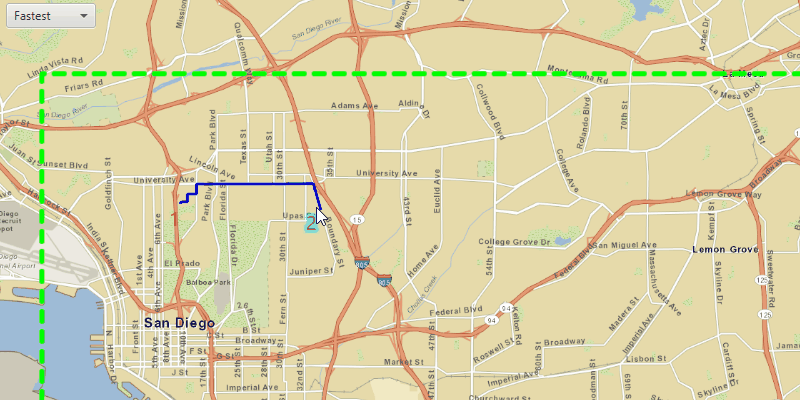
Left-click near a road to add a stop to the route. A number graphic will show its order in the route. After adding at least 2 stops, a route will display. Choose "Fastest" or "Shortest" from the drop down menu to control how the route is optimized. To move a stop, right-click the graphic to select it, move your mouse to reposition and finally right-click again to set the new position. The route will update on-the-fly while moving stops. The green box marks the boundary of the routable area provided by the offline data.
How it works
- Create the map's
Basemapfrom a local tile package using aTileCacheandArcGISTiledLayer. - Create a
RouteTaskwith an offline locator geodatabase. - Get the
RouteParametersusingrouteTask.createDefaultParameters(). - Create
Stops and add them to the route task's parameters. - Solve the
RouteusingrouteTask.solveRouteAsync(routeParameters). - Create a graphic with the route's geometry and a
SimpleLineSymboland display it on anotherGraphicsOverlay.
About the data
This sample uses a pre-packaged sample dataset consisting of a geodatabase with a San Diego road network and a tile package with a streets basemap.
Relevant API
- RouteParameters
- RouteResult
- RouteTask
- Stop
- TravelMode
Tags
connectivity, disconnected, fastest, locator, navigation, network analysis, offline, routing, shortest, turn-by-turn
Sample Code
/*
* Copyright 2017 Esri.
*
* Licensed under the Apache License, Version 2.0 (the "License"); you may not
* use this file except in compliance with the License. You may obtain a copy of
* the License at
*
* http://www.apache.org/licenses/LICENSE-2.0
*
* Unless required by applicable law or agreed to in writing, software
* distributed under the License is distributed on an "AS IS" BASIS, WITHOUT
* WARRANTIES OR CONDITIONS OF ANY KIND, either express or implied. See the
* License for the specific language governing permissions and limitations under
* the License.
*/
package com.esri.samples.offline_routing;
import java.io.File;
import java.util.Arrays;
import java.util.List;
import java.util.concurrent.ExecutionException;
import java.util.stream.Collectors;
import javafx.application.Application;
import javafx.application.Platform;
import javafx.event.EventHandler;
import javafx.geometry.Insets;
import javafx.geometry.Point2D;
import javafx.geometry.Pos;
import javafx.scene.Scene;
import javafx.scene.control.Alert;
import javafx.scene.control.ComboBox;
import javafx.scene.input.MouseButton;
import javafx.scene.input.MouseEvent;
import javafx.scene.layout.StackPane;
import javafx.scene.paint.Color;
import javafx.stage.Stage;
import javafx.util.StringConverter;
import com.esri.arcgisruntime.concurrent.ListenableFuture;
import com.esri.arcgisruntime.data.TileCache;
import com.esri.arcgisruntime.geometry.Envelope;
import com.esri.arcgisruntime.geometry.Point;
import com.esri.arcgisruntime.geometry.SpatialReferences;
import com.esri.arcgisruntime.layers.ArcGISTiledLayer;
import com.esri.arcgisruntime.loadable.LoadStatus;
import com.esri.arcgisruntime.mapping.ArcGISMap;
import com.esri.arcgisruntime.mapping.Basemap;
import com.esri.arcgisruntime.mapping.view.Graphic;
import com.esri.arcgisruntime.mapping.view.GraphicsOverlay;
import com.esri.arcgisruntime.mapping.view.IdentifyGraphicsOverlayResult;
import com.esri.arcgisruntime.mapping.view.MapView;
import com.esri.arcgisruntime.symbology.LineSymbol;
import com.esri.arcgisruntime.symbology.SimpleLineSymbol;
import com.esri.arcgisruntime.symbology.TextSymbol;
import com.esri.arcgisruntime.tasks.networkanalysis.Route;
import com.esri.arcgisruntime.tasks.networkanalysis.RouteParameters;
import com.esri.arcgisruntime.tasks.networkanalysis.RouteResult;
import com.esri.arcgisruntime.tasks.networkanalysis.RouteTask;
import com.esri.arcgisruntime.tasks.networkanalysis.Stop;
import com.esri.arcgisruntime.tasks.networkanalysis.TravelMode;
public class OfflineRoutingSample extends Application {
private MapView mapView;
private GraphicsOverlay stopsOverlay;
private GraphicsOverlay routeOverlay;
private RouteTask routeTask;
private RouteParameters routeParameters;
private LineSymbol lineSymbol;
private EventHandler<MouseEvent> mouseMovedListener;
@Override
public void start(Stage stage) {
try {
// create stack pane and application scene
StackPane stackPane = new StackPane();
Scene scene = new Scene(stackPane);
scene.getStylesheets().add(getClass().getResource("/offline_routing/style.css").toExternalForm());
// set title, size, and add scene to stage
stage.setTitle("Offline Routing Sample");
stage.setWidth(800);
stage.setHeight(700);
stage.setScene(scene);
stage.show();
// create the map's basemap from a local tile package
File tpkFile = new File(System.getProperty("data.dir"), "./samples-data/sandiego/streetmap_SD.tpkx");
TileCache tileCache = new TileCache(tpkFile.getAbsolutePath());
ArcGISTiledLayer tiledLayer = new ArcGISTiledLayer(tileCache);
Basemap basemap = new Basemap(tiledLayer);
ArcGISMap map = new ArcGISMap(basemap);
mapView = new MapView();
mapView.setMap(map);
// create graphics overlays for route and stops
stopsOverlay = new GraphicsOverlay();
routeOverlay = new GraphicsOverlay();
mapView.getGraphicsOverlays().addAll(Arrays.asList(routeOverlay, stopsOverlay));
ComboBox<TravelMode> travelModes = new ComboBox<>();
travelModes.getSelectionModel().selectedItemProperty().addListener(o -> {
routeParameters.setTravelMode(travelModes.getSelectionModel().getSelectedItem());
updateRoute();
});
// display travel mode name within combobox
travelModes.setConverter(new StringConverter<TravelMode>() {
@Override
public String toString(TravelMode travelMode) {
return travelMode != null ? travelMode.getName() : "";
}
@Override
public TravelMode fromString(String fileName) {
return null;
}
});
// create an offline RouteTask
File geodatabaseFile = new File(System.getProperty("data.dir"), "./samples-data/sandiego/sandiego.geodatabase");
routeTask = new RouteTask(geodatabaseFile.getAbsolutePath(), "Streets_ND");
routeTask.loadAsync();
routeTask.addDoneLoadingListener(() -> {
if (routeTask.getLoadStatus() == LoadStatus.LOADED) {
try {
// create route parameters
routeParameters = routeTask.createDefaultParametersAsync().get();
travelModes.getItems().addAll(routeTask.getRouteTaskInfo().getTravelModes());
travelModes.getSelectionModel().select(0);
} catch (InterruptedException | ExecutionException e) {
displayMessage("Error getting default route parameters", e.getMessage());
}
} else {
displayMessage("Error loading route task", routeTask.getLoadError().getMessage());
}
});
// add a graphics overlay to show the boundary
Envelope envelope = new Envelope(new Point(-13045352.223196, 3864910.900750, 0, SpatialReferences.getWebMercator()),
new Point(-13024588.857198, 3838880.505604, 0, SpatialReferences.getWebMercator()));
SimpleLineSymbol boundarySymbol = new SimpleLineSymbol(SimpleLineSymbol.Style.DASH, Color.LIME, 5);
Graphic boundary = new Graphic(envelope, boundarySymbol);
GraphicsOverlay boundaryOverlay = new GraphicsOverlay();
boundaryOverlay.getGraphics().add(boundary);
mapView.getGraphicsOverlays().add(boundaryOverlay);
// create symbol for route
lineSymbol = new SimpleLineSymbol(SimpleLineSymbol.Style.SOLID, Color.BLUE, 3);
// create mouse moved event listener to update the route when moving stops
mouseMovedListener = event -> {
if (!stopsOverlay.getSelectedGraphics().isEmpty()) {
Point2D hoverLocation = new Point2D(event.getX(), event.getY());
Point hoverPoint = mapView.screenToLocation(hoverLocation);
// update the moving stop and graphic
Graphic stopGraphic = stopsOverlay.getSelectedGraphics().get(0);
stopGraphic.setGeometry(hoverPoint);
// update route
if (stopsOverlay.getGraphics().size() > 1) {
updateRoute();
}
}
};
// use mouse clicks to add and move stops
mapView.setOnMouseClicked(event -> {
if (routeTask.getLoadStatus() == LoadStatus.LOADED && event.isStillSincePress()) {
// get mouse click location
Point2D clickLocation = new Point2D(event.getX(), event.getY());
Point point = mapView.screenToLocation(clickLocation);
// left click adds a stop when not already moving a stop
if (event.getButton() == MouseButton.PRIMARY && stopsOverlay.getSelectedGraphics().isEmpty()) {
// create graphic for stop
TextSymbol stopLabel = new TextSymbol(20, Integer.toString(stopsOverlay.getGraphics().size() + 1),
Color.RED, TextSymbol.HorizontalAlignment.RIGHT, TextSymbol.VerticalAlignment.TOP);
// create and add the stop graphic to the graphics overlay and list
Graphic stopGraphic = new Graphic(point, stopLabel);
stopsOverlay.getGraphics().add(stopGraphic);
// update the route
updateRoute();
}
// right click to select/deselect a stop to move
if (event.getButton() == MouseButton.SECONDARY) {
// select a stop
if (stopsOverlay.getSelectedGraphics().isEmpty()) {
// identify the selected graphic
ListenableFuture<IdentifyGraphicsOverlayResult> results = mapView.identifyGraphicsOverlayAsync(
stopsOverlay, clickLocation, 10, false);
results.addDoneListener(() -> {
try {
List<Graphic> graphics = results.get().getGraphics();
if (graphics.size() > 0) {
// set the graphic as selected
Graphic graphic = graphics.get(0);
graphic.setSelected(true);
// add the mouse move event listener to update the route
mapView.setOnMouseMoved(mouseMovedListener);
}
} catch (InterruptedException | ExecutionException e) {
e.printStackTrace();
}
});
} else {
stopsOverlay.clearSelection();
// remove the mouse moved event listener when not moving stops
mapView.setOnMouseMoved(null);
}
}
}
});
// add controls to stackpane
stackPane.getChildren().addAll(mapView, travelModes);
StackPane.setAlignment(travelModes, Pos.TOP_LEFT);
StackPane.setMargin(travelModes, new Insets(10, 0, 0, 10));
} catch (Exception e) {
// on any error, display the stack trace.
e.printStackTrace();
}
}
/**
* Update the route based on the set or moving stops.
*/
private void updateRoute() {
if (stopsOverlay.getGraphics().size() > 1) {
// remove listener until route task is solved
if (!stopsOverlay.getSelectedGraphics().isEmpty()) {
mapView.setOnMouseMoved(null);
}
// update stops and solve route
List<Stop> stops = stopsOverlay.getGraphics().stream()
.map(g -> new Stop((Point) g.getGeometry()))
.collect(Collectors.toList());
routeParameters.setStops(stops);
ListenableFuture<RouteResult> results = routeTask.solveRouteAsync(routeParameters);
results.addDoneListener(() -> {
try {
RouteResult result = results.get();
Route route = result.getRoutes().get(0);
// create graphic for route
Graphic graphic = new Graphic(route.getRouteGeometry(), lineSymbol);
// replace route graphic
routeOverlay.getGraphics().clear();
routeOverlay.getGraphics().add(graphic);
} catch (InterruptedException | ExecutionException e) {
// ignore, no route solution
} finally {
// add mouse moved listener back
if (!stopsOverlay.getSelectedGraphics().isEmpty()) {
mapView.setOnMouseMoved(mouseMovedListener);
}
}
});
}
}
/**
* Shows a message in an alert dialog.
*
* @param title title of alert
* @param message message to display
*/
private void displayMessage(String title, String message) {
Platform.runLater(() -> {
Alert dialog = new Alert(Alert.AlertType.INFORMATION);
dialog.setHeaderText(title);
dialog.setContentText(message);
dialog.showAndWait();
});
}
/**
* Stops and releases all resources used in application.
*/
@Override
public void stop() {
if (mapView != null) {
mapView.dispose();
}
}
/**
* Opens and runs application.
*
* @param args arguments passed to this application
*/
public static void main(String[] args) {
Application.launch(args);
}
}