Analyze the viewshed for a camera. A viewshed shows the visible and obstructed areas from an observer's vantage point.
Use case
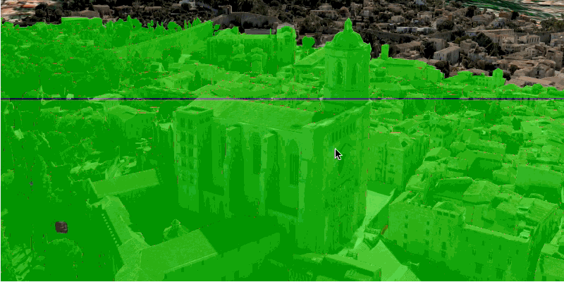
A viewshed analysis is a type of visual analysis you can perform on a scene. The viewshed aims to answer the question 'What can I see from a given location?'. The output is an overlay with two different colors - one representing the visible areas (green) and the other representing the obstructed areas (red).
How to use the sample
The sample will start with a viewshed created from the initial camera location, so only the visible (green) portion of the viewshed will be visible. Move around the scene to see the obstructed (red) portions. Click the 'Update from Camera' button to update the viewshed to the current camera position.
How it works
- Get the current camera from the scene with
SceneView.getCurrentViewpointCamera(). - Create a
LocationViewshed, passing in theCameraand a min/max distance. - Update the viewshed from a camera.
Relevant API
- AnalysisOverlay
- ArcGISScene
- ArcGISTiledElevationSource
- Camera
- IntegratedMeshLayer
- LocationViewshed
- SceneView
About the data
The scene shows an integrated mesh layer of Girona, Spain with the World Elevation source image service both hosted on ArcGIS Online.
Tags
3D, integrated mesh, scene, viewshed, visibility analysis
Sample Code
/*
* Copyright 2017 Esri.
*
* Licensed under the Apache License, Version 2.0 (the "License"); you may not
* use this file except in compliance with the License. You may obtain a copy of
* the License at
*
* http://www.apache.org/licenses/LICENSE-2.0
*
* Unless required by applicable law or agreed to in writing, software
* distributed under the License is distributed on an "AS IS" BASIS, WITHOUT
* WARRANTIES OR CONDITIONS OF ANY KIND, either express or implied. See the
* License for the specific language governing permissions and limitations under
* the License.
*/
package com.esri.samples.viewshed_camera;
import javafx.application.Application;
import javafx.geometry.Insets;
import javafx.geometry.Pos;
import javafx.scene.Scene;
import javafx.scene.control.Button;
import javafx.scene.layout.StackPane;
import javafx.stage.Stage;
import com.esri.arcgisruntime.ArcGISRuntimeEnvironment;
import com.esri.arcgisruntime.geoanalysis.LocationViewshed;
import com.esri.arcgisruntime.layers.IntegratedMeshLayer;
import com.esri.arcgisruntime.mapping.ArcGISScene;
import com.esri.arcgisruntime.mapping.ArcGISTiledElevationSource;
import com.esri.arcgisruntime.mapping.BasemapStyle;
import com.esri.arcgisruntime.mapping.Surface;
import com.esri.arcgisruntime.mapping.view.AnalysisOverlay;
import com.esri.arcgisruntime.mapping.view.Camera;
import com.esri.arcgisruntime.mapping.view.SceneView;
public class ViewshedCameraSample extends Application {
private SceneView sceneView;
@Override
public void start(Stage stage) {
try {
// create stack pane and JavaFX app scene
StackPane stackPane = new StackPane();
Scene fxScene = new Scene(stackPane);
// set title, size, and add JavaFX scene to stage
stage.setTitle("Viewshed Camera Sample");
stage.setWidth(800);
stage.setHeight(700);
stage.setScene(fxScene);
stage.show();
// authentication with an API key or named user is required to access basemaps and other location services
String yourAPIKey = System.getProperty("apiKey");
ArcGISRuntimeEnvironment.setApiKey(yourAPIKey);
// create a scene with a basemap style
ArcGISScene scene = new ArcGISScene(BasemapStyle.ARCGIS_IMAGERY);
// add the SceneView to the stack pane
sceneView = new SceneView();
sceneView.setArcGISScene(scene);
// set the camera
Camera camera = new Camera(41.985, 2.82691, 124.987, 332.131, 82.4732, 0.0);
sceneView.setViewpointCamera(camera);
// add base surface for elevation data
Surface surface = new Surface();
final String elevationSourceUri = "https://elevation3d.arcgis.com/arcgis/rest/services/WorldElevation3D/Terrain3D/ImageServer";
surface.getElevationSources().add(new ArcGISTiledElevationSource(elevationSourceUri));
scene.setBaseSurface(surface);
// add an integrated mesh layer (city of Girona, Spain)
IntegratedMeshLayer gironaMeshLayer =
new IntegratedMeshLayer("https://tiles.arcgis.com/tiles/z2tnIkrLQ2BRzr6P/arcgis/rest/services/Girona_Spain/SceneServer");
scene.getOperationalLayers().add(gironaMeshLayer);
// create a viewshed from the camera
LocationViewshed viewshed = new LocationViewshed(camera, 1.0, 500.0);
viewshed.setFrustumOutlineVisible(true);
// create an analysis overlay to add the viewshed to the scene view
AnalysisOverlay analysisOverlay = new AnalysisOverlay();
analysisOverlay.getAnalyses().add(viewshed);
sceneView.getAnalysisOverlays().add(analysisOverlay);
// create a button to update the viewshed with the current camera
Button cameraButton = new Button("Update from camera");
cameraButton.setOnMouseClicked(e -> viewshed.updateFromCamera(sceneView.getCurrentViewpointCamera()));
// add the sceneview and button to the stackpane
stackPane.getChildren().addAll(sceneView, cameraButton);
StackPane.setAlignment(cameraButton, Pos.TOP_LEFT);
StackPane.setMargin(cameraButton, new Insets(10, 0, 0, 10));
} catch (Exception e) {
// on any error, display the stack trace.
e.printStackTrace();
}
}
/**
* Stops and releases all resources used in application.
*/
@Override
public void stop() {
if (sceneView != null) {
sceneView.dispose();
}
}
/**
* Opens and runs application.
*
* @param args arguments passed to this application
*/
public static void main(String[] args) {
Application.launch(args);
}
}