Display your location history on the map.
Use case
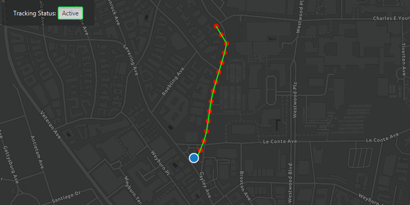
You can track device location history and display it as lines and points on the map. The history can be used to visualize how the user moved through the world, to retrace their steps, or to create new feature geometry. For example, an unmapped trail could be added to the map using this technique.
How to use the sample
The sample loads with a moving simulated location data source. Click the button to start tracking the location, which will appear as red points on the map. A green line will connect the points for easier visualization. Click the button again to stop updating the location history.
How it works
- Create a
GraphicsOverlayto show each point and anotherGraphicsOverlayfor displaying the route line. - Create a
SimulatedLocationDataSourceand call itssetLocations()method, passing the routePolylineand newSimulationParametersas parameters. Start theSimulatedLocationDataSourceto begin receiving location updates. - Use a
LocationChangedListeneron thesimulatedLocationDataSourceto get location updates. - When the location updates store that location, display a point on the map at the location, and re-create the route polyline.
Relevant API
- LocationDataSource.LocationChangedEvent
- LocationDataSource.LocationChangedListener
- LocationDisplay.AutoPanMode
- MapView.LocationDisplay
- SimulatedLocationDataSource
- SimulationParameters
About the data
A custom set of points (provided in JSON format) is used to create a Polyline and configure a SimulatedLocationDataSource. The simulated location data source enables easier testing and allows the sample to be used on devices without an actively updating GPS signal. To track a user's real position, use NMEALocationDataSource instead.
Tags
bread crumb, breadcrumb, GPS, history, movement, navigation, real-time, trace, track, trail
Sample Code
/*
* Copyright 2020 Esri
*
* Licensed under the Apache License, Version 2.0 (the "License");
* you may not use this file except in compliance with the License.
* You may obtain a copy of the License at
*
* http://www.apache.org/licenses/LICENSE-2.0
*
* Unless required by applicable law or agreed to in writing, software
* distributed under the License is distributed on an "AS IS" BASIS,
* WITHOUT WARRANTIES OR CONDITIONS OF ANY KIND, either express or implied.
* See the License for the specific language governing permissions and
* limitations under the License.
*
*/
package com.esri.samples.show_location_history;
import java.nio.charset.StandardCharsets;
import java.util.Arrays;
import java.util.Calendar;
import javafx.application.Application;
import javafx.geometry.Insets;
import javafx.geometry.Pos;
import javafx.scene.Scene;
import javafx.scene.control.Alert;
import javafx.scene.control.Label;
import javafx.scene.control.ToggleButton;
import javafx.scene.layout.Background;
import javafx.scene.layout.BackgroundFill;
import javafx.scene.layout.CornerRadii;
import javafx.scene.layout.HBox;
import javafx.scene.layout.StackPane;
import javafx.scene.paint.Color;
import javafx.scene.paint.Paint;
import javafx.stage.Stage;
import com.esri.arcgisruntime.ArcGISRuntimeEnvironment;
import com.esri.arcgisruntime.geometry.Geometry;
import com.esri.arcgisruntime.geometry.Point;
import com.esri.arcgisruntime.geometry.Polyline;
import com.esri.arcgisruntime.geometry.PolylineBuilder;
import com.esri.arcgisruntime.geometry.SpatialReferences;
import com.esri.arcgisruntime.loadable.LoadStatus;
import com.esri.arcgisruntime.location.LocationDataSource;
import com.esri.arcgisruntime.location.LocationDataSource.LocationChangedListener;
import com.esri.arcgisruntime.location.SimulatedLocationDataSource;
import com.esri.arcgisruntime.location.SimulationParameters;
import com.esri.arcgisruntime.mapping.ArcGISMap;
import com.esri.arcgisruntime.mapping.BasemapStyle;
import com.esri.arcgisruntime.mapping.Viewpoint;
import com.esri.arcgisruntime.mapping.view.Graphic;
import com.esri.arcgisruntime.mapping.view.GraphicsOverlay;
import com.esri.arcgisruntime.mapping.view.LocationDisplay;
import com.esri.arcgisruntime.mapping.view.MapView;
import com.esri.arcgisruntime.symbology.SimpleLineSymbol;
import com.esri.arcgisruntime.symbology.SimpleMarkerSymbol;
import com.esri.arcgisruntime.symbology.SimpleRenderer;
import org.apache.commons.io.IOUtils;
public class ShowLocationHistorySample extends Application {
private MapView mapView;
private Point position;
@Override
public void start(Stage stage) {
try {
// create stack pane and application scene
StackPane stackPane = new StackPane();
Scene scene = new Scene(stackPane);
// set title, size, and add scene to stage
stage.setTitle("Show Location History Sample");
stage.setWidth(800);
stage.setHeight(700);
stage.setScene(scene);
stage.show();
scene.getStylesheets().add(getClass().getResource("/show_location_history/style.css").toExternalForm());
// authentication with an API key or named user is required to access basemaps and other location services
String yourAPIKey = System.getProperty("apiKey");
ArcGISRuntimeEnvironment.setApiKey(yourAPIKey);
// create a map with the dark gray basemap style
ArcGISMap map = new ArcGISMap(BasemapStyle.ARCGIS_DARK_GRAY);
// create a map view and set the map to it
mapView = new MapView();
mapView.setMap(map);
// set a viewpoint on the map view centered on Los Angeles, California
mapView.setViewpoint(new Viewpoint(new Point(-13185535.98, 4037766.28, SpatialReferences.getWebMercator()), 7000));
// create a label
Label trackingLabel = new Label("Tracking Status: ");
// create a button that toggles the location tracking
ToggleButton trackingButton = new ToggleButton("Start");
trackingButton.maxWidth(Double.MAX_VALUE);
trackingButton.setDisable(true);
// create a graphics overlay for the points and use a red circle for the symbols
GraphicsOverlay locationHistoryOverlay = new GraphicsOverlay();
SimpleMarkerSymbol locationSymbol = new SimpleMarkerSymbol(SimpleMarkerSymbol.Style.CIRCLE, Color.RED, 10f);
SimpleRenderer locationHistoryRenderer = new SimpleRenderer(locationSymbol);
locationHistoryOverlay.setRenderer(locationHistoryRenderer);
// create a graphics overlay for the lines connecting the points and use a green line for the symbol
GraphicsOverlay locationHistoryLineOverlay = new GraphicsOverlay();
SimpleLineSymbol locationLineSymbol = new SimpleLineSymbol(SimpleLineSymbol.Style.SOLID, Color.LIME, 2.0f);
SimpleRenderer locationHistoryLineRenderer = new SimpleRenderer(locationLineSymbol);
locationHistoryLineOverlay.setRenderer(locationHistoryLineRenderer);
// add the graphics overlays to the map view
mapView.getGraphicsOverlays().addAll(Arrays.asList(locationHistoryOverlay, locationHistoryLineOverlay));
// create a polyline builder to connect the location points
PolylineBuilder polylineBuilder = new PolylineBuilder(SpatialReferences.getWebMercator());
// access the json of the location points
String polylineData = IOUtils.toString(getClass().getResourceAsStream("/show_location_history/polyline_data.json"), StandardCharsets.UTF_8);
// create a polyline from the location points
Polyline routePolyline = (Polyline) Geometry.fromJson(polylineData, SpatialReferences.getWebMercator());
// create a simulated location data source
SimulatedLocationDataSource simulatedLocationDataSource = new SimulatedLocationDataSource();
// set the location of the simulated location data source with simulation parameters to set a consistent velocity
simulatedLocationDataSource.setLocations(
routePolyline, new SimulationParameters(Calendar.getInstance(), 30.0, 0.0, 0.0));
// configure the map view's location display to follow the simulated location data source
LocationDisplay locationDisplay = mapView.getLocationDisplay();
locationDisplay.setLocationDataSource(simulatedLocationDataSource);
locationDisplay.setAutoPanMode(LocationDisplay.AutoPanMode.RECENTER);
locationDisplay.setInitialZoomScale(7000);
// create a listener to track the previous location, to draw a route line behind the location display symbol
LocationChangedListener locationChangedListener =
(LocationDataSource.LocationChangedEvent locationChangedEvent) -> {
// reset the old polyline connecting the points
locationHistoryLineOverlay.getGraphics().clear();
// add any previous position to the history
if (position != null) {
// add the new point to the polyline
polylineBuilder.addPoint(position);
// add the new point to the graphics overlay
locationHistoryOverlay.getGraphics().add(new Graphic(position));
}
// store the current position
position = locationChangedEvent.getLocation().getPosition();
// add the updated polyline to the graphics overlay
locationHistoryLineOverlay.getGraphics().add(new Graphic(polylineBuilder.toGeometry()));
};
trackingButton.setOnAction(event -> {
// if the user has panned away from the location display, turn it on again
if (locationDisplay.getAutoPanMode() == LocationDisplay.AutoPanMode.OFF) {
locationDisplay.setAutoPanMode(LocationDisplay.AutoPanMode.RECENTER);
}
// toggle the location tracking when the button is clicked
if (trackingButton.isSelected()) {
simulatedLocationDataSource.addLocationChangedListener(locationChangedListener);
trackingButton.setText("Active");
trackingButton.setStyle("-fx-focus-color: #00ff00;");
} else {
simulatedLocationDataSource.removeLocationChangedListener(locationChangedListener);
trackingButton.setText("Stopped");
trackingButton.setStyle("-fx-focus-color: #f16345;");
}
});
// enable the button interactions when the map is loaded
map.addDoneLoadingListener(() -> {
if (map.getLoadStatus() == LoadStatus.LOADED) {
trackingButton.setDisable(false);
// start the simulated location data source
simulatedLocationDataSource.startAsync();
} else {
new Alert(Alert.AlertType.ERROR, "Map failed to load: " + map.getLoadError().getCause().getMessage()).show();
}
});
// create a control panel and add the label and button UI components
HBox controlsHBox = new HBox();
controlsHBox.setBackground(new Background(new BackgroundFill(Paint.valueOf("rgba(0,0,0,0.3)"), CornerRadii.EMPTY, Insets.EMPTY)));
controlsHBox.setPadding(new Insets(10.0));
controlsHBox.setAlignment(Pos.CENTER);
controlsHBox.setMaxSize(210, 50);
controlsHBox.getStyleClass().add("panel-region");
controlsHBox.getChildren().addAll(trackingLabel, trackingButton);
// add the map view and control panel to the stack pane
stackPane.getChildren().addAll(mapView, controlsHBox);
StackPane.setAlignment(controlsHBox, Pos.TOP_LEFT);
StackPane.setMargin(controlsHBox, new Insets(10, 0, 0, 10));
} catch (Exception e) {
// on any error, display the stack trace.
e.printStackTrace();
}
}
/**
* Stops and releases all resources used in application.
*/
@Override
public void stop() {
if (mapView != null) {
mapView.dispose();
}
}
/**
* Opens and runs application.
*
* @param args arguments passed to this application
*/
public static void main(String[] args) {
Application.launch(args);
}
}