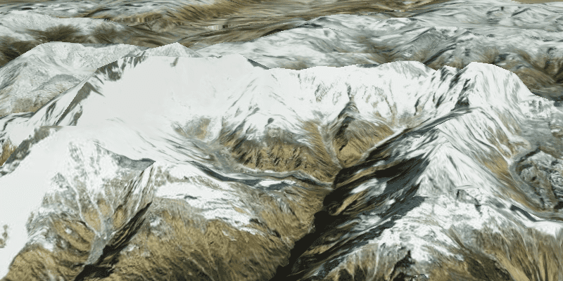
Display a scene with a terrain surface and some imagery.
Use case
Scene views are 3D representations of real-world areas and objects. Scene views are helpful for visualizing complex datasets where 3D relationships, topography, and elevation of elements are important factors.
How to use the sample
When loaded, the sample will display a scene. Pan and zoom to explore the scene.
How it works
- Create an
ArcGISScenewith the imagery basemap style. - Create an
ArcGISTiledElevationSourceand add it to the scene's base surface. - Create a
SceneViewobject to display the map. - Set the scene to the scene view.
Relevant API
- ArcGISScene
- ArcGISTiledElevationSource
- SceneView
Tags
3D, basemap, elevation, scene, surface
Sample Code
DisplaySceneSample.java
/*
* Copyright 2017 Esri.
*
* Licensed under the Apache License, Version 2.0 (the "License"); you may not
* use this file except in compliance with the License. You may obtain a copy of
* the License at
*
* http://www.apache.org/licenses/LICENSE-2.0
*
* Unless required by applicable law or agreed to in writing, software
* distributed under the License is distributed on an "AS IS" BASIS, WITHOUT
* WARRANTIES OR CONDITIONS OF ANY KIND, either express or implied. See the
* License for the specific language governing permissions and limitations under
* the License.
*/
package com.esri.samples.display_scene;
import javafx.application.Application;
import javafx.scene.Scene;
import javafx.scene.layout.StackPane;
import javafx.stage.Stage;
import com.esri.arcgisruntime.ArcGISRuntimeEnvironment;
import com.esri.arcgisruntime.mapping.ArcGISScene;
import com.esri.arcgisruntime.mapping.ArcGISTiledElevationSource;
import com.esri.arcgisruntime.mapping.BasemapStyle;
import com.esri.arcgisruntime.mapping.Surface;
import com.esri.arcgisruntime.mapping.view.Camera;
import com.esri.arcgisruntime.mapping.view.SceneView;
public class DisplaySceneSample extends Application {
private SceneView sceneView;
private static final String ELEVATION_IMAGE_SERVICE =
"https://elevation3d.arcgis.com/arcgis/rest/services/WorldElevation3D/Terrain3D/ImageServer";
@Override
public void start(Stage stage) {
try {
// create stack pane and JavaFX app scene
StackPane stackPane = new StackPane();
Scene fxScene = new Scene(stackPane);
// set title, size, and add JavaFX scene to stage
stage.setTitle("Display Scene Sample");
stage.setWidth(800);
stage.setHeight(700);
stage.setScene(fxScene);
stage.show();
// authentication with an API key or named user is required to access basemaps and other location services
String yourAPIKey = System.getProperty("apiKey");
ArcGISRuntimeEnvironment.setApiKey(yourAPIKey);
// create a scene with a basemap style
ArcGISScene scene = new ArcGISScene(BasemapStyle.ARCGIS_IMAGERY);
// add the SceneView to the stack pane
sceneView = new SceneView();
sceneView.setArcGISScene(scene);
stackPane.getChildren().addAll(sceneView);
// add base surface for elevation data
Surface surface = new Surface();
surface.getElevationSources().add(new ArcGISTiledElevationSource(ELEVATION_IMAGE_SERVICE));
scene.setBaseSurface(surface);
// add a camera and initial camera position
Camera camera = new Camera(28.4, 83.9, 10010.0, 10.0, 80.0, 0.0);
sceneView.setViewpointCamera(camera);
} catch (Exception e) {
// on any error, display the stack trace.
e.printStackTrace();
}
}
/**
* Stops and releases all resources used in application.
*/
@Override
public void stop() {
if (sceneView != null) {
sceneView.dispose();
}
}
/**
* Opens and runs application.
*
* @param args arguments passed to this application
*/
public static void main(String[] args) {
Application.launch(args);
}
}