See through terrain in a scene and move the camera underground.
Use case
By default, a scene's terrain is fully opaque and the camera cannot go underground. To see underground features such as pipes in a utility network, you can lower the opacity of the terrain surface and set the navigation constraint on the surface to allow underground navigation.
How to use the sample
The sample loads a scene with underground features. Pan and zoom to explore the scene. Observe how the opacity of the base surface is reduced and the navigation constraint is removed, allowing you to pan and zoom through the base surface.
How it works
- Display an
ArcGISScenein aSceneViewwhich contains layers with underground features. - To see underground, get the scene's base surface and set its opacity to a value between 0 and 1.
- To allow the camera to go underground, set the surface's navigation constraint to
NONE.
Relevant API
- Surface
- NavigationConstraint
About the data
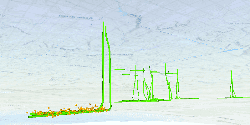
This data is a point scene layer showing underground wellbore paths (green polylines) and seismic events (light brown points).
Tags
3D, subsurface, underground, utilities
Sample Code
package com.esri.samples.view_content_beneath_terrain_surface;
import javafx.application.Application;
import javafx.scene.Scene;
import javafx.scene.control.ProgressIndicator;
import javafx.scene.layout.StackPane;
import javafx.stage.Stage;
import com.esri.arcgisruntime.mapping.ArcGISScene;
import com.esri.arcgisruntime.mapping.NavigationConstraint;
import com.esri.arcgisruntime.mapping.view.DrawStatus;
import com.esri.arcgisruntime.mapping.view.SceneView;
public class ViewContentBeneathTerrainSurfaceSample extends Application {
private SceneView sceneView;
private ArcGISScene scene; // keep loadable in scope to avoid garbage collection
@Override
public void start(Stage stage) throws Exception {
// create stack pane and JavaFX app scene
StackPane stackPane = new StackPane();
Scene fxScene = new Scene(stackPane);
// set title, size, and add JavaFX scene to stage
stage.setTitle("View Content Beneath Terrain Surface Sample");
stage.setWidth(800);
stage.setHeight(700);
stage.setScene(fxScene);
stage.show();
// create a scene from a web scene Url and set it to the scene view
scene = new ArcGISScene("https://www.arcgis.com/home/item.html?id=91a4fafd747a47c7bab7797066cb9272");
sceneView = new SceneView();
sceneView.setArcGISScene(scene);
// add a progress indicator and display it when scene view drawing is in progress
var progressIndicator = new ProgressIndicator();
progressIndicator.visibleProperty().bind(sceneView.drawStatusProperty().isEqualTo(DrawStatus.IN_PROGRESS));
// once the scene has loaded, set the navigation constraint and opacity of the base surface
scene.addDoneLoadingListener(() -> {
// ensure the navigation constraint is set to NONE to view content beneath the terrain surface
scene.getBaseSurface().setNavigationConstraint(NavigationConstraint.NONE);
// set opacity to view content beneath the base surface
scene.getBaseSurface().setOpacity(0.4f);
});
// add the scene view and progress indicator to the stack pane
stackPane.getChildren().addAll(sceneView, progressIndicator);
}
/**
* Stops and releases all resources used in application.
*/
@Override
public void stop() {
if (sceneView != null) {
sceneView.dispose();
}
}
/**
* Opens and runs application.
*
* @param args arguments passed to this application
*/
public static void main(String[] args) {
Application.launch(args);
}
}