Vertically exaggerate terrain in a scene.
Use case
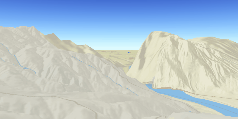
Vertical exaggeration can be used to emphasize subtle changes in a surface. This can be useful in creating visualizations of terrain where the horizontal extent of the surface is significantly greater than the amount of vertical change in the surface. A fractional vertical exaggeration can be used to flatten surfaces or features that have extreme vertical variation.
How to use the sample
Use the slider to update terrain exaggeration.
How it works
- Create an elevation surface from a URL with
Surface.getElevationSources().add("elevationURL"). An elevation source defines the terrain based on a digital elevation model (DEM) or digital terrain model (DTM). - Add the surface to the scene with
scene.setBaseSurface(Surface). The surface visualizes the elevation source. - Configure the surface's elevation exaggeration using
surface.setElevationExaggeration(exaggeration).
Relevant API
- ArcGISScene
- Surface
Tags
3D, DEM, DTM, elevation, scene, surface, terrain
Sample Code
/*
* Copyright 2017 Esri.
*
* Licensed under the Apache License, Version 2.0 (the "License"); you may not
* use this file except in compliance with the License. You may obtain a copy of
* the License at
*
* http://www.apache.org/licenses/LICENSE-2.0
*
* Unless required by applicable law or agreed to in writing, software
* distributed under the License is distributed on an "AS IS" BASIS, WITHOUT
* WARRANTIES OR CONDITIONS OF ANY KIND, either express or implied. See the
* License for the specific language governing permissions and limitations under
* the License.
*/
package com.esri.samples.terrain_exaggeration;
import javafx.fxml.FXML;
import javafx.scene.control.Label;
import javafx.scene.control.Slider;
import com.esri.arcgisruntime.ArcGISRuntimeEnvironment;
import com.esri.arcgisruntime.geometry.Point;
import com.esri.arcgisruntime.mapping.ArcGISScene;
import com.esri.arcgisruntime.mapping.ArcGISTiledElevationSource;
import com.esri.arcgisruntime.mapping.BasemapStyle;
import com.esri.arcgisruntime.mapping.Surface;
import com.esri.arcgisruntime.mapping.view.Camera;
import com.esri.arcgisruntime.mapping.view.SceneView;
public class TerrainExaggerationController {
@FXML private Label exaggerationLabel;
@FXML private SceneView sceneView;
@FXML private Slider exaggerationSlider;
private Surface surface;
public void initialize() {
try {
// authentication with an API key or named user is required to access basemaps and other location services
String yourAPIKey = System.getProperty("apiKey");
ArcGISRuntimeEnvironment.setApiKey(yourAPIKey);
// create a scene with a basemap style
ArcGISScene scene = new ArcGISScene(BasemapStyle.ARCGIS_STREETS_RELIEF);
// add the SceneView to the stack pane
sceneView.setArcGISScene(scene);
// add base surface for elevation data
surface = new Surface();
final String elevationImageService =
"https://elevation3d.arcgis.com/arcgis/rest/services/WorldElevation3D/Terrain3D/ImageServer";
surface.getElevationSources().add(new ArcGISTiledElevationSource(elevationImageService));
scene.setBaseSurface(surface);
// add a camera and initial camera position
Point initialLocation = new Point(-119.94891542688772, 46.75792111605992, 0, sceneView.getSpatialReference());
Camera camera = new Camera(initialLocation, 15000.0, 40.0, 60.0, 0.0);
sceneView.setViewpointCamera(camera);
} catch (Exception e) {
// on any exception, print the stack trace
e.printStackTrace();
}
}
/**
* Sets the elevation exaggeration to the float chosen via the JavaFX slider.
*/
@FXML
private void changeElevationExaggeration() {
exaggerationLabel.setText("Exaggeration: " + (double) Math.round(exaggerationSlider.getValue() * 100d) / 100d);
surface.setElevationExaggeration((float) exaggerationSlider.getValue());
}
/**
* Disposes application resources.
*/
void terminate() {
if (sceneView != null) {
sceneView.dispose();
}
}
}