Create a raster layer from a raster image service.
Use case
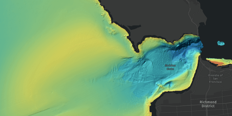
Accessing a raster image from an online service can be useful for analysing the most up-to-date data available for an area. For example, retrieving recent results of bathymetry surveys within a shipping channel monitored for its sediment build-up would allow planners to assess dredging needs.
How to use the sample
Simply launch the sample to see a raster from an image service being used on a map.
How it works
To add a RasterLayer as an operational layer from an ImageServiceRaster:
- Create an
ImageServiceRasterusing the service's URL - Create a
RasterLayerfrom the raster - Add it as an operational layer with
map.getOperationalLayers().add(rasterLayer)
Relevant API
- ImageServiceRaster
- RasterLayer
About the data
This sample uses a NOAA raster image service. The service computes a hillshade image from the depth (in meters) of U.S. coastal waters.
Tags
image service, raster
Sample Code
RasterLayerURLSample.java
/*
* Copyright 2017 Esri.
*
* Licensed under the Apache License, Version 2.0 (the "License"); you may not
* use this file except in compliance with the License. You may obtain a copy of
* the License at
*
* http://www.apache.org/licenses/LICENSE-2.0
*
* Unless required by applicable law or agreed to in writing, software
* distributed under the License is distributed on an "AS IS" BASIS, WITHOUT
* WARRANTIES OR CONDITIONS OF ANY KIND, either express or implied. See the
* License for the specific language governing permissions and limitations under
* the License.
*/
package com.esri.samples.raster_layer_url;
import javafx.application.Application;
import javafx.scene.Scene;
import javafx.scene.control.Alert;
import javafx.scene.layout.StackPane;
import javafx.stage.Stage;
import com.esri.arcgisruntime.ArcGISRuntimeEnvironment;
import com.esri.arcgisruntime.geometry.Point;
import com.esri.arcgisruntime.geometry.SpatialReferences;
import com.esri.arcgisruntime.layers.RasterLayer;
import com.esri.arcgisruntime.loadable.LoadStatus;
import com.esri.arcgisruntime.mapping.ArcGISMap;
import com.esri.arcgisruntime.mapping.BasemapStyle;
import com.esri.arcgisruntime.mapping.view.MapView;
import com.esri.arcgisruntime.raster.ImageServiceRaster;
public class RasterLayerURLSample extends Application {
private MapView mapView;
private RasterLayer rasterLayer; // keep loadable in scope to avoid garbage collection
@Override
public void start(Stage stage) {
try {
// create stack pane and application scene
StackPane stackPane = new StackPane();
Scene scene = new Scene(stackPane);
// set title, size, and add scene to stage
stage.setTitle("Raster Layer URL Sample");
stage.setWidth(800);
stage.setHeight(700);
stage.setScene(scene);
stage.show();
// authentication with an API key or named user is required to access basemaps and other location services
String yourAPIKey = System.getProperty("apiKey");
ArcGISRuntimeEnvironment.setApiKey(yourAPIKey);
// create an image service raster from an online raster service
ImageServiceRaster imageServiceRaster = new ImageServiceRaster("https://gis.ngdc.noaa.gov/arcgis/rest/services/bag_hillshades_subsets/ImageServer");
// create a raster layer
rasterLayer = new RasterLayer(imageServiceRaster);
rasterLayer.addDoneLoadingListener(() -> {
if (rasterLayer.getLoadStatus() != LoadStatus.LOADED) {
new Alert(Alert.AlertType.ERROR, "Raster layer failed to load").show();
}
});
// create a map with the dark gray basemap style
ArcGISMap map = new ArcGISMap(BasemapStyle.ARCGIS_DARK_GRAY);
// create a map view and set the map to it
mapView = new MapView();
mapView.setMap(map);
// zoom in to the San Francisco Bay
mapView.setViewpointCenterAsync(new Point(-13643095.660131, 4550009.846004, SpatialReferences.getWebMercator()), 100000);
// add the raster layer as an operational layer
map.getOperationalLayers().add(rasterLayer);
// add the map view to stack pane
stackPane.getChildren().addAll(mapView);
} catch (Exception e) {
// on any error, display the stack trace.
e.printStackTrace();
}
}
/**
* Stops and releases all resources used in application.
*/
@Override
public void stop() {
if (mapView != null) {
mapView.dispose();
}
}
/**
* Opens and runs application.
*
* @param args arguments passed to this application
*/
public static void main(String[] args) {
Application.launch(args);
}
}