Determine the map's load status which can be: NOT_LOADED, FAILED_TO_LOAD, LOADING, LOADED.
Use case
Knowing the map's load state may be required before subsequent actions can be executed.
How to use the sample
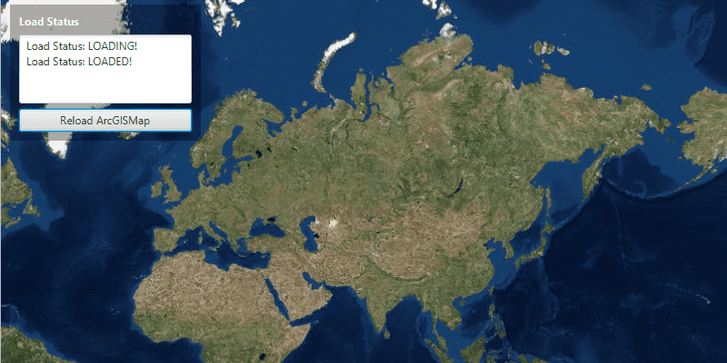
Click on the button to reload the ArcGISMap. The load status of the ArcGISMap will be displayed on screen.
How it works
- Create an
ArcGISMapand add it to aMapView. - Use
ArcGISMap.addLoadStatusChangedListener()orArcGISMap.getNewLoadStatus()to query the map's load status.
The LoadStatus is LOADED when any of the following criteria are met:
- The map has a valid spatial reference.
- The map has an an initial viewpoint.
- One of the map's predefined layers has been created.
Relevant API
- ArcGISMap
- MapView
Tags
LoadStatus, map, loadable pattern
Sample Code
AccessLoadStatusSample.java
/*
* Copyright 2017 Esri.
*
* Licensed under the Apache License, Version 2.0 (the "License"); you may not
* use this file except in compliance with the License. You may obtain a copy of
* the License at
*
* http://www.apache.org/licenses/LICENSE-2.0
*
* Unless required by applicable law or agreed to in writing, software
* distributed under the License is distributed on an "AS IS" BASIS, WITHOUT
* WARRANTIES OR CONDITIONS OF ANY KIND, either express or implied. See the
* License for the specific language governing permissions and limitations under
* the License.
*/
package com.esri.samples.access_load_status;
import javafx.application.Application;
import javafx.application.Platform;
import javafx.geometry.Insets;
import javafx.geometry.Pos;
import javafx.scene.Scene;
import javafx.scene.control.Button;
import javafx.scene.control.Label;
import javafx.scene.control.TextArea;
import javafx.scene.layout.Background;
import javafx.scene.layout.BackgroundFill;
import javafx.scene.layout.CornerRadii;
import javafx.scene.layout.StackPane;
import javafx.scene.layout.VBox;
import javafx.scene.paint.Paint;
import javafx.stage.Stage;
import com.esri.arcgisruntime.ArcGISRuntimeEnvironment;
import com.esri.arcgisruntime.mapping.ArcGISMap;
import com.esri.arcgisruntime.mapping.BasemapStyle;
import com.esri.arcgisruntime.mapping.view.MapView;
public class AccessLoadStatusSample extends Application {
private MapView mapView;
private ArcGISMap map;
@Override
public void start(Stage stage) {
try {
// create stack pane and application scene
StackPane stackPane = new StackPane();
Scene scene = new Scene(stackPane);
scene.getStylesheets().add(getClass().getResource("/access_load_status/style.css").toExternalForm());
// set title, size, and add scene to stage
stage.setTitle("Access Load Status Sample");
stage.setWidth(800);
stage.setHeight(700);
stage.setScene(scene);
stage.show();
// authentication with an API key or named user is required to access basemaps and other location services
String yourAPIKey = System.getProperty("apiKey");
ArcGISRuntimeEnvironment.setApiKey(yourAPIKey);
// create a control panel
var controlsVBox = new VBox(6);
controlsVBox.setBackground(new Background(new BackgroundFill(Paint.valueOf("rgba(0,0,0,0.3)"), CornerRadii.EMPTY,
Insets.EMPTY)));
controlsVBox.setPadding(new Insets(10.0));
controlsVBox.setMaxSize(210, 150);
controlsVBox.getStyleClass().add("panel-region");
// create area to display load status text
var loadStatusLabel = new Label("Load Status");
loadStatusLabel.getStyleClass().add("panel-label");
TextArea loadStatusText = new TextArea();
loadStatusText.setMaxHeight(200);
var reloadMapButton = new Button("Reload ArcGISMap");
reloadMapButton.setMaxWidth(Double.MAX_VALUE);
// reload the map when the button is clicked
reloadMapButton.setOnAction(event -> {
loadStatusText.clear();
// reload the map
map = new ArcGISMap(BasemapStyle.ARCGIS_IMAGERY_STANDARD);
map.loadStatusProperty().addListener((observable, oldValue, newValue) -> {
// create and update a string variable depending on the load status
String loadingStatus;
switch (newValue) {
case LOADING:
loadingStatus = "Load Status: LOADING!";
break;
case FAILED_TO_LOAD:
loadingStatus = "Load Status: FAILED TO LOAD!";
break;
case NOT_LOADED:
loadingStatus = "Load Status: NOT LOADED!";
break;
case LOADED:
loadingStatus = "Load Status: LOADED!";
break;
default:
loadingStatus = "Load Status: ERROR!";
}
// update the load status text to the loading status that was fired
Platform.runLater(() -> loadStatusText.appendText(loadingStatus + "\n"));
});
mapView.setMap(map);
});
// add label, text and button to the control panel
controlsVBox.getChildren().addAll(loadStatusLabel, loadStatusText, reloadMapButton);
// create a map with the standard imagery basemap style
map = new ArcGISMap(BasemapStyle.ARCGIS_IMAGERY_STANDARD);
// create a map view and set the map to it
mapView = new MapView();
mapView.setMap(map);
// add the map view and control panel to stack pane
stackPane.getChildren().addAll(mapView, controlsVBox);
StackPane.setAlignment(controlsVBox, Pos.TOP_LEFT);
StackPane.setMargin(controlsVBox, new Insets(10, 0, 0, 10));
} catch (Exception e) {
// on any error, display the stack trace
e.printStackTrace();
}
}
/**
* Stops and releases all resources used in application.
*/
@Override
public void stop() {
if (mapView != null) {
mapView.dispose();
}
}
/**
* Opens and runs application.
*
* @param args arguments passed to this application
*/
public static void main(String[] args) {
Application.launch(args);
}
}