Find a route to the closest facility from a location.
Use case
Quickly and accurately determining the most efficient route between a location and a facility is a frequently encountered task. For example, a paramedic may need to know which hospital in the vicinity offers the possibility of getting an ambulance patient critical medical care in the shortest amount of time. Solving for the closest hospital to the ambulance’s location using an impedance of “travel time” would provide this information.
How to use the sample
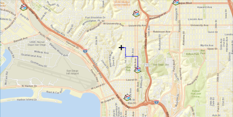
Click near any of the hospitals and a route will be displayed from that location to the nearest hospital.
How it works
- Create a
ClosestFacilityTaskusing a Url from an online network analysis service. - Get
ClosestFacilityParametersfrom task,task.createDefaultParametersAsync().get(). - Add the list of facilities to parameters,
closestFacilityParameters.setFacilities(facilitiesList). - Add the incident to parameters,
closestFacilityParameters.setIncidents(Collections.singletonList(new Incident(incidentPoint))). - Get
ClosestFacilityResultfrom solving task with parameters,task.solveClosestFacilityAsync(facilityParameters).get(). - Get index list of closet facilities to incident,
facilityResult.getRankedFacilitiesIndexes(0). - Get index of closest facility,
rankedFacilitiesList.get(0). - Find closest facility route,
facilityResult.getRoute(closestFacilityIndex, IncidentIndex). - Display route to
MapView:- Create
Graphicfrom route geometry,new Graphic(route.getRouteGeometry(), routeSymbol). - Add graphic to
GraphicsOverlaywhich is attached to the mapview.
- Create
Relevant API
- ClosestFacilityParameters
- ClosestFacilityResult
- ClosestFacilityRoute
- ClosestFacilityTask
- Facility
- Graphic
- GraphicsOverlay
- Incident
- MapView
Tags
incident, network analysis, route, search
Sample Code
/* * Copyright 2022 Esri. * * Licensed under the Apache License, Version 2.0 (the "License"); * you may not use this file except in compliance with the License. * You may obtain a copy of the License at * * http://www.apache.org/licenses/LICENSE-2.0 * * Unless required by applicable law or agreed to in writing, software * distributed under the License is distributed on an "AS IS" BASIS, * WITHOUT WARRANTIES OR CONDITIONS OF ANY KIND, either express or implied. * See the License for the specific language governing permissions and * limitations under the License. */module com.esri.samples.closest_facility {  // require ArcGIS Maps SDK for Java module  requires com.esri.arcgisruntime;
  // handle SLF4J http://www.slf4j.org/codes.html#StaticLoggerBinder  requires org.slf4j.nop;
  // require JavaFX modules that the application uses  requires javafx.graphics;  requires javafx.controls;
  exports com.esri.samples.closest_facility;}
/* * Copyright 2017 Esri. * * Licensed under the Apache License, Version 2.0 (the "License"); you may not * use this file except in compliance with the License. You may obtain a copy of * the License at * * http://www.apache.org/licenses/LICENSE-2.0 * * Unless required by applicable law or agreed to in writing, software * distributed under the License is distributed on an "AS IS" BASIS, WITHOUT * WARRANTIES OR CONDITIONS OF ANY KIND, either express or implied. See the * License for the specific language governing permissions and limitations under * the License. */
package com.esri.samples.closest_facility;
import java.util.Arrays;import java.util.Collections;import java.util.List;import java.util.concurrent.ExecutionException;import java.util.stream.Collectors;
import javafx.application.Application;import javafx.geometry.Point2D;import javafx.scene.Scene;import javafx.scene.control.Alert;import javafx.scene.control.Alert.AlertType;import javafx.scene.input.MouseButton;import javafx.scene.layout.StackPane;import javafx.scene.paint.Color;import javafx.stage.Stage;
import com.esri.arcgisruntime.ArcGISRuntimeEnvironment;import com.esri.arcgisruntime.concurrent.ListenableFuture;import com.esri.arcgisruntime.geometry.Point;import com.esri.arcgisruntime.geometry.SpatialReference;import com.esri.arcgisruntime.geometry.SpatialReferences;import com.esri.arcgisruntime.loadable.LoadStatus;import com.esri.arcgisruntime.mapping.ArcGISMap;import com.esri.arcgisruntime.mapping.BasemapStyle;import com.esri.arcgisruntime.mapping.Viewpoint;import com.esri.arcgisruntime.mapping.view.Graphic;import com.esri.arcgisruntime.mapping.view.GraphicsOverlay;import com.esri.arcgisruntime.mapping.view.MapView;import com.esri.arcgisruntime.symbology.PictureMarkerSymbol;import com.esri.arcgisruntime.symbology.SimpleLineSymbol;import com.esri.arcgisruntime.symbology.SimpleMarkerSymbol;import com.esri.arcgisruntime.tasks.networkanalysis.ClosestFacilityParameters;import com.esri.arcgisruntime.tasks.networkanalysis.ClosestFacilityResult;import com.esri.arcgisruntime.tasks.networkanalysis.ClosestFacilityRoute;import com.esri.arcgisruntime.tasks.networkanalysis.ClosestFacilityTask;import com.esri.arcgisruntime.tasks.networkanalysis.Facility;import com.esri.arcgisruntime.tasks.networkanalysis.Incident;
public class ClosestFacilitySample extends Application {
// black cross were user clicked private Point incidentPoint; private GraphicsOverlay facilityGraphicsOverlay; private GraphicsOverlay incidentGraphicsOverlay; // holds locations of hospitals around San Diego private List<Facility> facilities; private MapView mapView; // solves task to find closest route between an incident and a facility private ClosestFacilityTask task; // parameters needed to solve for route private ClosestFacilityParameters closestFacilityParameters; // used to display route between incident and facility to mapview private SimpleLineSymbol routeSymbol; // same spatial reference of the map private final SpatialReference spatialReference = SpatialReferences.getWebMercator();
@Override public void start(Stage stage) {
// pane will hold mapview to be displayed on application StackPane stackPane = new StackPane(); Scene scene = new Scene(stackPane);
// set title, size, and add scene to stage stage.setTitle("Closest Facility Sample"); stage.setWidth(800); stage.setHeight(700); stage.setScene(scene); stage.show();
try {
// authentication with an API key or named user is required to access basemaps and other location services String yourAPIKey = System.getProperty("apiKey"); ArcGISRuntimeEnvironment.setApiKey(yourAPIKey);
// create a map with the streets basemap style ArcGISMap map = new ArcGISMap(BasemapStyle.ARCGIS_STREETS);
// create a map view and set the map to it mapView = new MapView(); mapView.setMap(map);
// add the map view to stack pane stackPane.getChildren().addAll(mapView);
// set a viewpoint on the map view to be over San Diego mapView.setViewpoint(new Viewpoint(32.727, -117.1750, 40000));
facilityGraphicsOverlay = new GraphicsOverlay(); incidentGraphicsOverlay = new GraphicsOverlay(); createFacilitiesAndGraphics(); // to load graphics faster, add graphics overlay to view once all graphics are in graphics overlay mapView.getGraphicsOverlays().add(facilityGraphicsOverlay); mapView.getGraphicsOverlays().add(incidentGraphicsOverlay);
// task to find the closest route between an incident and a facility final String sanDiegoRegion = "https://sampleserver6.arcgisonline.com/arcgis/rest/services/NetworkAnalysis/SanDiego/NAServer/ClosestFacility"; task = new ClosestFacilityTask(sanDiegoRegion); task.addDoneLoadingListener(() -> { if (task.getLoadStatus() == LoadStatus.LOADED) { try { closestFacilityParameters = task.createDefaultParametersAsync().get(); // set new parameters to find route closestFacilityParameters.setFacilities(facilities); } catch (ExecutionException | InterruptedException e) { e.printStackTrace(); } } else { Alert alert = new Alert(Alert.AlertType.ERROR, "Closest Facility Task Failed to Load!"); alert.show(); } }); task.loadAsync();
// symbols that display incident (black cross) and route (blue line) to view SimpleMarkerSymbol incidentSymbol = new SimpleMarkerSymbol(SimpleMarkerSymbol.Style.CROSS, Color.BLACK, 20); routeSymbol = new SimpleLineSymbol(SimpleLineSymbol.Style.SOLID, Color.BLUE, 2.0f);
// place incident were user clicks and display route to closest facility mapView.setOnMouseClicked(e -> { // check that the primary mouse button was clicked if (e.getButton() == MouseButton.PRIMARY && e.isStillSincePress()) { // remove last incident from view incidentGraphicsOverlay.getGraphics().clear(); // show incident to the mapview Point mapPoint = mapView.screenToLocation(new Point2D(e.getX(), e.getY())); incidentPoint = new Point(mapPoint.getX(), mapPoint.getY(), spatialReference); Graphic graphic = new Graphic(incidentPoint, incidentSymbol); incidentGraphicsOverlay.getGraphics().add(graphic);
populateParametersAndSolveRoute(); } }); } catch (Exception e) { // on any error, display the stack trace. e.printStackTrace(); } }
/** * Creates facilities around the San Diego region. * <p> * Facilities are created using point geometry which is then used to make graphics for the graphics overlay. */ private void createFacilitiesAndGraphics() { // List of facilities to be placed around San Diego area facilities = Arrays.asList( new Facility(new Point(-1.3042129900625112E7, 3860127.9479775648, spatialReference)), new Facility(new Point(-1.3042193400557665E7, 3862448.873041752, spatialReference)), new Facility(new Point(-1.3046882875518233E7, 3862704.9896770366, spatialReference)), new Facility(new Point(-1.3040539754780494E7, 3862924.5938606677, spatialReference)), new Facility(new Point(-1.3042571225655518E7, 3858981.773018156, spatialReference)), new Facility(new Point(-1.3039784633928463E7, 3856692.5980474586, spatialReference)), new Facility(new Point(-1.3049023883956768E7, 3861993.789732541, spatialReference)));
// image for displaying facility String facilityUrl = "https://static.arcgis.com/images/Symbols/SafetyHealth/Hospital.png"; PictureMarkerSymbol facilitySymbol = new PictureMarkerSymbol(facilityUrl); facilitySymbol.setHeight(30); facilitySymbol.setWidth(30);
// for each facility, create a graphic and add to graphics overlay facilities.stream().map(f -> new Graphic(f.getGeometry(), facilitySymbol)) .collect(Collectors.toCollection(() -> facilityGraphicsOverlay.getGraphics())); }
/** * Adds facilities(hospitals) and user's incident(black cross) to closest facility parameters which will be used to * display the closest route from the user's incident to its' nearest facility. */ private void populateParametersAndSolveRoute() { closestFacilityParameters.setIncidents(Collections.singletonList(new Incident(incidentPoint)));
// find closest route using parameters from above ListenableFuture<ClosestFacilityResult> result = task.solveClosestFacilityAsync(closestFacilityParameters); result.addDoneListener(() -> { try { ClosestFacilityResult facilityResult = result.get(); // a list of closest facilities based on users incident List<Integer> rankedList = facilityResult.getRankedFacilityIndexes(0); // get the index of the closest facility to incident int closestFacility = rankedList.get(0); // get route from incident to closest facility and display to mapview ClosestFacilityRoute route = facilityResult.getRoute(closestFacility, 0); incidentGraphicsOverlay.getGraphics().add(new Graphic(route.getRouteGeometry(), routeSymbol)); } catch (ExecutionException e) { if (e.getMessage().contains("Unable to complete operation")) { Alert dialog = new Alert(AlertType.WARNING); dialog.setHeaderText(null); dialog.setTitle("Route Error"); dialog.setContentText("Incident not within San Diego area!"); dialog.showAndWait(); } else { e.printStackTrace(); } } catch (InterruptedException e) { e.printStackTrace(); } }); }
/** * Stops and releases all resources used in application. */ @Override public void stop() {
if (mapView != null) { mapView.dispose(); } }
/** * Opens and runs application. * * @param args arguments passed to this application */ public static void main(String[] args) {
Application.launch(args); }
}