Add a scene layer to a scene.
Use case
Each scene layer added to a scene can assist in performing helpful visual analysis. For example, if presenting the results of a shadow analysis of a major metropolitan downtown area in 3D, adding a scene layer of 3D buildings to the scene that could be toggled on/off would help to better contextualize the source of the shadows.
How to use the sample
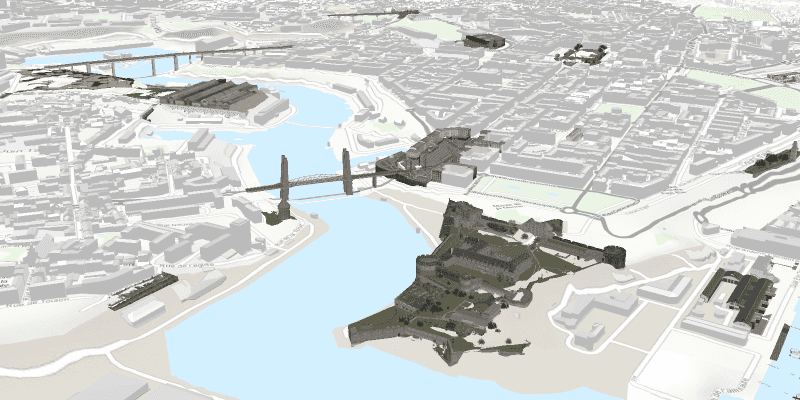
When launched, this sample displays a scene service with an ArcGISSceneLayer. Pan and zoom to explore the scene.
How it works
- Create an
ArcGISSceneand set itsBasemapwithArcGISScene.setBasemap(). - Create a
SceneViewand set the scene to the view withsceneView.setScene(scene). - Create an
ArcGISSceneLayerusing a data source URI:new ArcGISSceneLayer(Uri). - Add the new scene layer to the scene as an operational layer with
ArcGISScene.getOperationalLayers().add(sceneLayer).
About the data
The scene shows a buildings layer in Brest, France hosted on ArcGIS Online.
Relevant API
- ArcGISScene
- ArcGISSceneLayer
- SceneView
Tags
3D, layer, scene
Sample Code
SceneLayerSample.java
/*
* Copyright 2017 Esri.
*
* Licensed under the Apache License, Version 2.0 (the "License"); you may not
* use this file except in compliance with the License. You may obtain a copy of
* the License at
*
* http://www.apache.org/licenses/LICENSE-2.0
*
* Unless required by applicable law or agreed to in writing, software
* distributed under the License is distributed on an "AS IS" BASIS, WITHOUT
* WARRANTIES OR CONDITIONS OF ANY KIND, either express or implied. See the
* License for the specific language governing permissions and limitations under
* the License.
*/
package com.esri.samples.scene_layer;
import javafx.application.Application;
import javafx.scene.Scene;
import javafx.scene.layout.StackPane;
import javafx.stage.Stage;
import com.esri.arcgisruntime.ArcGISRuntimeEnvironment;
import com.esri.arcgisruntime.layers.ArcGISSceneLayer;
import com.esri.arcgisruntime.mapping.ArcGISScene;
import com.esri.arcgisruntime.mapping.ArcGISTiledElevationSource;
import com.esri.arcgisruntime.mapping.BasemapStyle;
import com.esri.arcgisruntime.mapping.Surface;
import com.esri.arcgisruntime.mapping.view.Camera;
import com.esri.arcgisruntime.mapping.view.SceneView;
public class SceneLayerSample extends Application {
private SceneView sceneView;
@Override
public void start(Stage stage) {
try {
// create stack pane and JavaFX app scene
StackPane stackPane = new StackPane();
Scene fxScene = new Scene(stackPane);
// set title, size, and add JavaFX scene to stage
stage.setTitle("Scene Layer Sample");
stage.setWidth(800);
stage.setHeight(700);
stage.setScene(fxScene);
stage.show();
// authentication with an API key or named user is required to access basemaps and other location services
String yourAPIKey = System.getProperty("apiKey");
ArcGISRuntimeEnvironment.setApiKey(yourAPIKey);
// create a scene with a basemap style
ArcGISScene scene = new ArcGISScene(BasemapStyle.ARCGIS_STREETS_RELIEF);
// set the scene to the scene view, and add the scene view to the stack pane
sceneView = new SceneView();
sceneView.setArcGISScene(scene);
stackPane.getChildren().addAll(sceneView);
// add base surface for elevation data
Surface surface = new Surface();
final String elevationImageService = "https://elevation3d.arcgis.com" +
"/arcgis/rest/services/WorldElevation3D/Terrain3D/ImageServer";
surface.getElevationSources().add(new ArcGISTiledElevationSource(elevationImageService));
scene.setBaseSurface(surface);
// add a scene layer
final String buildings = "https://tiles.arcgis.com/tiles/P3ePLMYs2RVChkJx/arcgis/rest/services/Buildings_Brest/SceneServer/layers/0";
ArcGISSceneLayer sceneLayer = new ArcGISSceneLayer(buildings);
scene.getOperationalLayers().add(sceneLayer);
// add a camera and initial camera position (Brest, France)
Camera camera = new Camera(48.37, -4.50, 1000.0, 10.0, 70, 0.0);
sceneView.setViewpointCamera(camera);
} catch (Exception e) {
// on any error, display the stack trace.
e.printStackTrace();
}
}
/**
* Stops and releases all resources used in application.
*/
@Override
public void stop() {
if (sceneView != null) {
sceneView.dispose();
}
}
/**
* Opens and runs application.
*
* @param args arguments passed to this application
*/
public static void main(String[] args) {
Application.launch(args);
}
}