Create a custom dynamic entity data source and display it using a dynamic entity layer.
Use case
Developers can create a custom DynamicEntityDataSource to be able to visualize data from a variety of different feeds as dynamic
entities using a DynamicEntityLayer. An example of this is in a mobile situational awareness app, where a custom
DynamicEntityDataSource can be used to connect to peer-to-peer feeds in order to visualize real-time location tracks from
teammates in the field.
How to use the sample
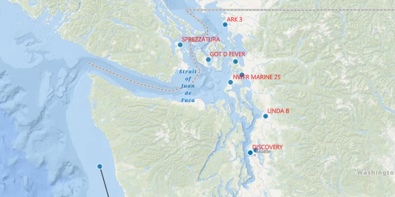
Run the sample to view the map and the dynamic entity layer displaying the latest observation from the custom data source.
How it works
Configure the custom data source:
- Create a custom data source implementation of a
DynamicEntityDataSource. - Override
onLoadAsync()to specify theDynamicEntityDataSourceInfofor a given unique entity ID field and a list ofFieldobjects matching the fields in the data source. - Override
onConnectAsync()to begin processing observations from the custom data source. - Loop through the observations and deserialize each observation into a
Geometryobject and aMap<String, Object>containing the attributes. - Use
DynamicEntityDataSource.addObservation(geometry, attributes)to add each observation to the custom data source.
Configure the map view:
- Create a
DynamicEntityLayerusing the custom data source implementation. - Update values in the layer’s
TrackDisplayPropertiesto customize the layer’s appearance. - Set up the layer’s
LabelDefinitionsto display labels for each dynamic entity.
Relevant API
- DynamicEntity
- DynamicEntityDataSource
- DynamicEntityLayer
- LabelDefinition
- TrackDisplayProperties
About the data
This sample uses a .json file containing observations of marine vessels in the Pacific North West hosted on ArcGIS Online.
Additional information
In this sample, we iterate through features in a GeoJSON file to mimic messages coming from a real-time feed. You can
create a custom dynamic entity data source to process any data that contains observations which can be translated into
Geometry objects with associated Map<String, Object> attributes.
Tags
data, dynamic, entity, label, labeling, live, real-time, stream, track
Sample code
/* * Copyright 2023 Esri. * * Licensed under the Apache License, Version 2.0 (the "License"); you may not * use this file except in compliance with the License. You may obtain a copy of * the License at * * http://www.apache.org/licenses/LICENSE-2.0 * * Unless required by applicable law or agreed to in writing, software * distributed under the License is distributed on an "AS IS" BASIS, WITHOUT * WARRANTIES OR CONDITIONS OF ANY KIND, either express or implied. See the * License for the specific language governing permissions and limitations under * the License. */
package com.esri.samples.add_custom_dynamic_entity_data_source;
import java.io.File;import java.util.concurrent.ExecutionException;import java.util.concurrent.TimeUnit;import java.util.concurrent.TimeoutException;
import com.esri.arcgisruntime.ArcGISRuntimeEnvironment;import com.esri.arcgisruntime.arcgisservices.LabelDefinition;import com.esri.arcgisruntime.geometry.Point;import com.esri.arcgisruntime.geometry.SpatialReferences;import com.esri.arcgisruntime.layers.DynamicEntityLayer;import com.esri.arcgisruntime.mapping.ArcGISMap;import com.esri.arcgisruntime.mapping.BasemapStyle;import com.esri.arcgisruntime.mapping.Viewpoint;import com.esri.arcgisruntime.mapping.labeling.SimpleLabelExpression;import com.esri.arcgisruntime.mapping.view.MapView;import com.esri.arcgisruntime.realtime.ConnectionStatus;import com.esri.arcgisruntime.symbology.TextSymbol;
import javafx.application.Application;import javafx.scene.Scene;import javafx.scene.layout.StackPane;import javafx.scene.paint.Color;import javafx.stage.Stage;
public class AddCustomDynamicEntityDataSourceSample extends Application {
  private MapView mapView;
  private SimulatedDataSource dynamicEntityDataSource;
  @Override  public void start(Stage stage) {    StackPane stackPane = new StackPane();    Scene scene = new Scene(stackPane);
    // set title, size, and add scene to stage    stage.setTitle("Add custom dynamic entity data source");    stage.setWidth(800);    stage.setHeight(700);    stage.setScene(scene);    stage.show();
    // authentication with an API key or named user is required to access basemaps and other location services    String yourAPIKey = System.getProperty("apiKey");    ArcGISRuntimeEnvironment.setApiKey(yourAPIKey);
    // create a new map with the oceans basemap style    ArcGISMap map = new ArcGISMap(BasemapStyle.ARCGIS_OCEANS);
    // create a map view and set the map to it    mapView = new MapView();    mapView.setMap(map);
    // set the initial viewpoint    mapView.setViewpoint(new Viewpoint(new Point(-123.657, 47.984, SpatialReferences.getWgs84()), 3e6));
    // a JSON file with observations for use as the custom data source    var resource = new File(System.getProperty("data.dir"), "./samples-data/real_time/AIS_MarineCadastre_SelectedVessels_CustomDataSource.json").getPath();
    // create a custom data source implementation of a DynamicEntityDataSource with a data source,    // an entity id field name (a unique identifier for each entity), and an update delay    dynamicEntityDataSource = new SimulatedDataSource(resource, "MMSI", 10);
    dynamicEntityDataSource.connectionStatusProperty().addListener((property, oldValue, newValue) -> {      if (newValue == ConnectionStatus.FAILED) {        System.err.println("The connection failed");      }    });
    dynamicEntityDataSource.connectionErrorProperty().addListener((property, oldValue, newValue) -> {      if (newValue != null) {        System.err.println("The connection failed: " + newValue.getMessage());      }    });
    // create the dynamic entity layer using the custom data source    var dynamicEntityLayer = new DynamicEntityLayer(dynamicEntityDataSource);
    // set up the track display properties    setupTrackDisplayProperties(dynamicEntityLayer);
    // set up the dynamic entity labeling    setupLabeling(dynamicEntityLayer);
    // add the dynamic entity layer to the map    map.getOperationalLayers().add(dynamicEntityLayer);
    // add the map view to the stack pane    stackPane.getChildren().addAll(mapView);  }
  /**   * Set up the track display properties, these properties will be used to configure the appearance of the track line   * and previous observations.   *   * @param layer the DynamicEntityLayer to be configured   */  private void setupTrackDisplayProperties(DynamicEntityLayer layer) {    var trackDisplayProperties = layer.getTrackDisplayProperties();    trackDisplayProperties.setShowPreviousObservations(true);    trackDisplayProperties.setShowTrackLine(true);    trackDisplayProperties.setMaximumDuration(200);  }
  /**   * Configure labeling on the layer to use a red label using the VesselName attribute.   *   * @param layer the DynamicEntityLayer for the labels   */  private void setupLabeling(DynamicEntityLayer layer) {    // define the label expression to be used, in this case we will use the "VesselName" for each of the dynamic entities    var simpleLabelExpression = new SimpleLabelExpression("[VesselName]");
    // set the text symbol color and size for the labels    var labelSymbol = new TextSymbol(12, "", Color.RED, TextSymbol.HorizontalAlignment.CENTER, TextSymbol.VerticalAlignment.BOTTOM);
    // set the label position    var labelDef = new LabelDefinition(simpleLabelExpression, labelSymbol);
    // add the label definition to the dynamic entity layer and enable labels    layer.getLabelDefinitions().add(labelDef);    layer.labelsEnabledProperty().set(true);  }
  /**   * Stops and releases all resources used in application.   */  @Override  public void stop() {    // notify the observations processing to stop    if (dynamicEntityDataSource != null) {      try {        dynamicEntityDataSource.disconnectAsync().get(2, TimeUnit.SECONDS);      } catch (InterruptedException | TimeoutException | ExecutionException e) {        System.err.println("Exception when disconnecting from data source: " + e);      }    }
    // release resources    if (mapView != null) {      mapView.dispose();    }  }
  /**   * Opens and runs application.   *   * @param args arguments passed to this application   */  public static void main(String[] args) {    launch(args);  }}
/* * Copyright 2023 Esri. * * Licensed under the Apache License, Version 2.0 (the "License"); you may not * use this file except in compliance with the License. You may obtain a copy of * the License at * * http://www.apache.org/licenses/LICENSE-2.0 * * Unless required by applicable law or agreed to in writing, software * distributed under the License is distributed on an "AS IS" BASIS, WITHOUT * WARRANTIES OR CONDITIONS OF ANY KIND, either express or implied. See the * License for the specific language governing permissions and limitations under * the License. */
package com.esri.samples.add_custom_dynamic_entity_data_source;
import java.io.BufferedReader;import java.io.FileReader;import java.io.IOException;import java.util.ArrayList;import java.util.HashMap;import java.util.List;import java.util.Objects;import java.util.concurrent.CompletableFuture;import java.util.concurrent.CompletionException;import java.util.concurrent.Executors;import java.util.concurrent.ScheduledExecutorService;import java.util.concurrent.ScheduledFuture;import java.util.concurrent.TimeUnit;import java.util.concurrent.atomic.AtomicInteger;
import com.google.gson.Gson;
import com.esri.arcgisruntime.data.Field;import com.esri.arcgisruntime.geometry.Point;import com.esri.arcgisruntime.geometry.SpatialReferences;import com.esri.arcgisruntime.realtime.DynamicEntityDataSource;import com.esri.arcgisruntime.realtime.DynamicEntityDataSourceInfo;
/** * A custom DynamicEntityDataSource for processing observations read from a given JSON file. */class SimulatedDataSource extends DynamicEntityDataSource {
private final String fileName; private final String entityIdFieldName; private final long delay; private final ScheduledExecutorService executorService = Executors.newSingleThreadScheduledExecutor(); private ScheduledFuture<?> observationProcessing; private final AtomicInteger currentLineNumber = new AtomicInteger(); private final List<String> allJsonLines = new ArrayList<>(); private final Gson gson = new Gson();
/** * Construct a custom DynamicEntityDataSource. * * @param fileName name of a file with JSON observation data * @param entityIdFieldName the name of the field containing values that uniquely identifies each entity * @param delay millisecond delay between observations being added to the data source */ SimulatedDataSource(String fileName, String entityIdFieldName, long delay) { this.fileName = fileName; this.entityIdFieldName = entityIdFieldName; this.delay = delay; }
@Override protected CompletableFuture<Void> onConnectAsync() { return new CompletableFuture<Void>().completeAsync(() -> { try { startProcessingObservations(); return null; } catch (IOException e) { throw new CompletionException(e); } }); }
/** * Read a file of observation data and start processing. */ private void startProcessingObservations() throws IOException { // store all lines from file in a list try (BufferedReader bufferedReader = new BufferedReader(new FileReader(fileName))) { allJsonLines.addAll(bufferedReader.lines().filter(Objects::nonNull).toList()); } catch (IOException e) { System.err.println("Failed to start processing observations: " + e.getMessage()); throw e; } // process file data a line at a time observationProcessing = executorService.scheduleAtFixedRate(this::processNextObservation, 0L, delay, TimeUnit.MILLISECONDS); }
/** * Process the next observation, canceling the task when all lines have been processed. */ private void processNextObservation() { int lineNumber = currentLineNumber.getAndAdd(1); if (lineNumber >= allJsonLines.size()) { // finished all the lines observationProcessing.cancel(false); } else { // process the line by parsing the JSON, and creating the observation, and adding to the data source var observation = gson.fromJson(allJsonLines.get(lineNumber), Observation.class); var point = new Point(observation.geometry.x, observation.geometry.y, SpatialReferences.getWgs84()); addObservation(point, observation.attributes); } }
@Override protected CompletableFuture<Void> onDisconnectAsync() { if (observationProcessing != null) { observationProcessing.cancel(true); } executorService.shutdown(); return CompletableFuture.completedFuture(null); }
@Override protected CompletableFuture<DynamicEntityDataSourceInfo> onLoadAsync() { var dynamicEntityDataSourceInfo = new DynamicEntityDataSourceInfo(entityIdFieldName, List.of( Field.createString("MMSI", null, 256), Field.createDouble("BaseDateTime", null), Field.createDouble("LAT", null), Field.createDouble("LONG", null), Field.createDouble("SOG", null), Field.createDouble("COG", null), Field.createDouble("Heading", null), Field.createString("VesselName", null, 256), Field.createString("IMO", null, 256), Field.createString("CallSign", null, 256), Field.createString("VesselType", null, 256), Field.createString("Status", null, 256), Field.createDouble("Length", null), Field.createDouble("Width", null), Field.createString("Cargo", null, 256), Field.createString("globalid", null, 256) )); dynamicEntityDataSourceInfo.setSpatialReference(SpatialReferences.getWgs84()); return CompletableFuture.completedFuture(dynamicEntityDataSourceInfo); }
@Override public String getUri() { return null; }
/** * Used by Gson for parsing the data. */ public static class ObservationSpatialReference { public int wkid; }
/** * Used by Gson for parsing the data. */ public static class ObservationGeometry { public double x; public double y; public ObservationSpatialReference spatialReference; }
/** * Used by Gson for parsing the data. */ public static class Observation { public ObservationGeometry geometry; public HashMap<String, Object> attributes; }}