Show various kinds of 3D symbols in a scene.
Use case
You can programmatically create different types of 3D symbols and add them to a scene at specified locations. You could do this to call attention to the prominence of a location.
How to use the sample
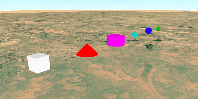
When the scene loads, note the different types of 3D symbols that you can create.
How it works
- Create a
GraphicsOverlay. - Create various simple marker scene symbols by specifying different styles and colors, and a height, width, depth, and anchor position of each.
- Create a new
Graphicobject for each symbol. - Add the graphics to the graphics overlay with
graphicsOverlay.getGraphics().add(graphic). - Add the graphics overlay to the scene view with
sceneView.getGraphicsOverlays().add(graphicsOverlay).
Relevant API
- Graphic
- GraphicsOverlay
- SceneSymbol.AnchorPosition
- SimpleMarkerSceneSymbol
- SimpleMarkerSceneSymbol.Style
About the data
This sample shows arbitrary symbols in an empty scene with an imagery basemap.
Tags
3D, cone, cube, cylinder, diamond, geometry, pyramid, scene, shape, sphere, symbol, tetrahedron, tube, visualization
Sample Code
SymbolsSample.java
/*
* Copyright 2017 Esri.
*
* Licensed under the Apache License, Version 2.0 (the "License"); you may not
* use this file except in compliance with the License. You may obtain a copy of
* the License at
*
* http://www.apache.org/licenses/LICENSE-2.0
*
* Unless required by applicable law or agreed to in writing, software
* distributed under the License is distributed on an "AS IS" BASIS, WITHOUT
* WARRANTIES OR CONDITIONS OF ANY KIND, either express or implied. See the
* License for the specific language governing permissions and limitations under
* the License.
*/
package com.esri.samples.symbols;
import java.util.concurrent.atomic.AtomicInteger;
import java.util.stream.Collectors;
import java.util.stream.Stream;
import javafx.application.Application;
import javafx.scene.Scene;
import javafx.scene.layout.StackPane;
import javafx.scene.paint.Color;
import javafx.stage.Stage;
import com.esri.arcgisruntime.ArcGISRuntimeEnvironment;
import com.esri.arcgisruntime.geometry.Point;
import com.esri.arcgisruntime.mapping.ArcGISScene;
import com.esri.arcgisruntime.mapping.ArcGISTiledElevationSource;
import com.esri.arcgisruntime.mapping.BasemapStyle;
import com.esri.arcgisruntime.mapping.Surface;
import com.esri.arcgisruntime.mapping.view.Camera;
import com.esri.arcgisruntime.mapping.view.Graphic;
import com.esri.arcgisruntime.mapping.view.GraphicsOverlay;
import com.esri.arcgisruntime.mapping.view.LayerSceneProperties;
import com.esri.arcgisruntime.mapping.view.SceneView;
import com.esri.arcgisruntime.symbology.SceneSymbol;
import com.esri.arcgisruntime.symbology.SimpleMarkerSceneSymbol;
public class SymbolsSample extends Application {
private SceneView sceneView;
private static final String ELEVATION_IMAGE_SERVICE =
"https://elevation3d.arcgis.com/arcgis/rest/services/WorldElevation3D/Terrain3D/ImageServer";
@Override
public void start(Stage stage) {
try {
// create stack pane and JavaFX app scene
StackPane stackPane = new StackPane();
Scene fxScene = new Scene(stackPane);
// set title, size, and add JavaFX scene to stage
stage.setTitle("Symbols Sample");
stage.setWidth(800);
stage.setHeight(700);
stage.setScene(fxScene);
stage.show();
// authentication with an API key or named user is required to access basemaps and other location services
String yourAPIKey = System.getProperty("apiKey");
ArcGISRuntimeEnvironment.setApiKey(yourAPIKey);
// create a scene with a basemap
ArcGISScene scene = new ArcGISScene(BasemapStyle.ARCGIS_IMAGERY);
// add the SceneView to the stack pane
sceneView = new SceneView();
sceneView.setArcGISScene(scene);
stackPane.getChildren().add(sceneView);
// add a camera and initial camera position
var camera = new Camera(28.985, 44.965, 1200, 50, 70, 0);
sceneView.setViewpointCamera(camera);
Point cameraLocation = camera.getLocation();
// add base surface for elevation data
var elevationSource = new ArcGISTiledElevationSource(ELEVATION_IMAGE_SERVICE);
var surface = new Surface();
surface.getElevationSources().add(elevationSource);
scene.setBaseSurface(surface);
// add graphics overlay(s)
var graphicsOverlay = new GraphicsOverlay();
graphicsOverlay.getSceneProperties().setSurfacePlacement(LayerSceneProperties.SurfacePlacement.ABSOLUTE);
sceneView.getGraphicsOverlays().add(graphicsOverlay);
// create graphics for each type of symbol
var counter = new AtomicInteger(0);
double x = 44.975;
double y = 29;
double z = 500;
Stream.of(SimpleMarkerSceneSymbol.Style.values()).map(style -> {
Color color;
switch (style) {
case CONE:
color = Color.RED;
break;
case TETRAHEDRON:
color = Color.LIMEGREEN;
break;
case SPHERE:
color = Color.BLUE;
break;
case CYLINDER:
color = Color.MAGENTA;
break;
case DIAMOND:
color = Color.TURQUOISE;
break;
case CUBE:
default:
color = Color.WHITE;
}
SimpleMarkerSceneSymbol symbol = new SimpleMarkerSceneSymbol(style, color, 200, 200, 200,
SceneSymbol.AnchorPosition.CENTER);
int position = counter.getAndIncrement();
return new Graphic(new Point(x + 0.01 * position, y, z, cameraLocation.getSpatialReference()), symbol);
}).collect(Collectors.toCollection(graphicsOverlay::getGraphics));
} catch (Exception e) {
// on any error, display the stack trace
e.printStackTrace();
}
}
/**
* Stops and releases all resources used in application.
*/
@Override
public void stop() {
if (sceneView != null) {
sceneView.dispose();
}
}
/**
* Opens and runs application.
*
* @param args arguments passed to this application
*/
public static void main(String[] args) {
Application.launch(args);
}
}