Perform a viewshed analysis from a defined vantage point.
Use case
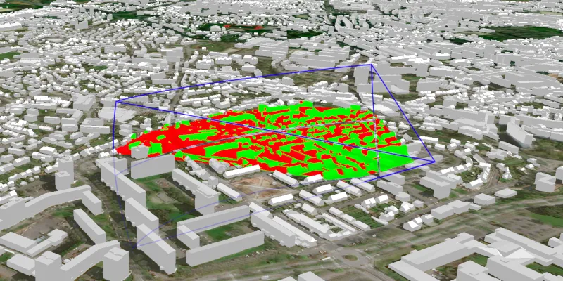
A 3D viewshed analysis is a type of visual analysis you can perform on a scene. The viewshed shows what can be seen from a given location. The output is an overlay with two different colors - one representing the visible areas (green) and the other representing the obstructed areas (red). Viewshed analysis is a form of “exploratory analysis”, which means the results are calculated on the current scale of the data, and the results are generated very quickly. If more “conclusive” results are required, consider using a GeoprocessingTask to perform a viewshed instead.
How to use the sample
Use the sliders to change the properties (heading, pitch, etc.), of the viewshed and see them updated in real time. To move the viewshed, click on the scene and move your mouse. Click again to stop moving the viewshed.
How it works
- Create a
LocationViewshedpassing in the observer location, heading, pitch, horizontal/vertical angles, and min/max distances. - Set the property values on the viewshed instance for location, direction, range, and visibility properties.
Relevant API
- AnalysisOverlay
- ArcGISSceneLayer
- ArcGISTiledElevationSource
- LocationViewshed
- Viewshed
About the data
The scene shows a buildings layer in Brest, France hosted on ArcGIS Online.
Tags
3D, frustum, scene, viewshed, visibility analysis
Sample code
/* * Copyright 2017 Esri. * * Licensed under the Apache License, Version 2.0 (the "License"); you may not * use this file except in compliance with the License. You may obtain a copy of * the License at * * http://www.apache.org/licenses/LICENSE-2.0 * * Unless required by applicable law or agreed to in writing, software * distributed under the License is distributed on an "AS IS" BASIS, WITHOUT * WARRANTIES OR CONDITIONS OF ANY KIND, either express or implied. See the * License for the specific language governing permissions and limitations under * the License. */
package com.esri.samples.viewshed_location;
import java.util.concurrent.ExecutionException;
import javafx.beans.binding.Bindings;import javafx.event.EventHandler;import javafx.fxml.FXML;import javafx.geometry.Point2D;import javafx.scene.control.Slider;import javafx.scene.control.ToggleButton;import javafx.scene.input.MouseButton;import javafx.scene.input.MouseEvent;import javafx.scene.paint.Color;
import com.esri.arcgisruntime.ArcGISRuntimeEnvironment;import com.esri.arcgisruntime.geoanalysis.LocationViewshed;import com.esri.arcgisruntime.geoanalysis.Viewshed;import com.esri.arcgisruntime.concurrent.ListenableFuture;import com.esri.arcgisruntime.geometry.Point;import com.esri.arcgisruntime.geometry.PointBuilder;import com.esri.arcgisruntime.layers.ArcGISSceneLayer;import com.esri.arcgisruntime.mapping.ArcGISScene;import com.esri.arcgisruntime.mapping.ArcGISTiledElevationSource;import com.esri.arcgisruntime.mapping.BasemapStyle;import com.esri.arcgisruntime.mapping.Surface;import com.esri.arcgisruntime.mapping.view.AnalysisOverlay;import com.esri.arcgisruntime.mapping.view.Camera;import com.esri.arcgisruntime.mapping.view.SceneView;
public class ViewshedLocationController {
  @FXML private SceneView sceneView;  @FXML private ToggleButton visibilityToggle;  @FXML private ToggleButton frustumToggle;  @FXML private Slider headingSlider;  @FXML private Slider pitchSlider;  @FXML private Slider horizontalAngleSlider;  @FXML private Slider verticalAngleSlider;  @FXML private Slider minDistanceSlider;  @FXML private Slider maxDistanceSlider;
  public void initialize() {
    // authentication with an API key or named user is required to access basemaps and other location services    String yourAPIKey = System.getProperty("apiKey");    ArcGISRuntimeEnvironment.setApiKey(yourAPIKey);
    // create a scene with a basemap style and set it to the scene view    ArcGISScene scene = new ArcGISScene(BasemapStyle.ARCGIS_IMAGERY);    sceneView.setArcGISScene(scene);
    // add base surface for elevation data    Surface surface = new Surface();    final String elevationImageService = "https://elevation3d.arcgis.com" +      "/arcgis/rest/services/WorldElevation3D/Terrain3D/ImageServer";    surface.getElevationSources().add(new ArcGISTiledElevationSource(elevationImageService));    scene.setBaseSurface(surface);
    // add a scene layer    final String buildings = "http://tiles.arcgis.com/tiles/P3ePLMYs2RVChkJx/arcgis/rest/services/Buildings_Brest/SceneServer/layers/0";    ArcGISSceneLayer sceneLayer = new ArcGISSceneLayer(buildings);    scene.getOperationalLayers().add(sceneLayer);
    // create a viewshed from the camera    Point location = new Point(-4.50, 48.4,100.0);    LocationViewshed viewshed = new LocationViewshed(location, headingSlider.getValue(), pitchSlider.getValue(),        horizontalAngleSlider.getValue(), verticalAngleSlider.getValue(), minDistanceSlider.getValue(),        maxDistanceSlider.getValue());    // set the colors of the visible and obstructed areas    Viewshed.setVisibleColor(Color.rgb(0, 255, 0, 0.8));    Viewshed.setObstructedColor(Color.rgb(255, 0, 0, 0.8));    // set the color and show the frustum outline    Viewshed.setFrustumOutlineColor(Color.rgb(0, 0, 255, 0.8));    viewshed.setFrustumOutlineVisible(true);
    // set the camera    Camera camera = new Camera(location, 200.0, 20.0, 70.0, 0.0);    sceneView.setViewpointCamera(camera);
    // create an analysis overlay to add the viewshed to the scene view    AnalysisOverlay analysisOverlay = new AnalysisOverlay();    analysisOverlay.getAnalyses().add(viewshed);    sceneView.getAnalysisOverlays().add(analysisOverlay);
    // create a listener to update the viewshed location when the mouse moves    EventHandler<MouseEvent> mouseMoveEventHandler = new EventHandler<MouseEvent>() {      @Override      public void handle(MouseEvent event) {        Point2D point2D = new Point2D(event.getX(), event.getY());        ListenableFuture<Point> pointFuture = sceneView.screenToLocationAsync(point2D);        pointFuture.addDoneListener(() -> {          try {            Point point = pointFuture.get();            PointBuilder pointBuilder = new PointBuilder(point);            pointBuilder.setZ(point.getZ() + 50.0);            viewshed.setLocation(pointBuilder.toGeometry());            // add listener back            sceneView.setOnMouseMoved(this);          } catch (InterruptedException | ExecutionException e) {            e.printStackTrace();          }        });        // disable listener until location is updated (for performance)        sceneView.setOnMouseMoved(null);      }    };    // remove the default listener for mouse move events    sceneView.setOnMouseMoved(null);
    // click to start/stop moving viewshed with mouse    sceneView.setOnMouseClicked(event -> {      if (event.isStillSincePress() && event.getButton() == MouseButton.PRIMARY) {        if (sceneView.getOnMouseMoved() == null) {          sceneView.setOnMouseMoved(mouseMoveEventHandler);        } else {          sceneView.setOnMouseMoved(null);        }      }    });
    // toggle visibility    visibilityToggle.selectedProperty().addListener(e -> viewshed.setVisible(visibilityToggle.isSelected()));    visibilityToggle.textProperty().bind(Bindings.createStringBinding(() -> visibilityToggle.isSelected() ? "ON" :        "OFF", visibilityToggle.selectedProperty()));    frustumToggle.selectedProperty().addListener(e -> viewshed.setFrustumOutlineVisible(frustumToggle.isSelected()));    frustumToggle.textProperty().bind(Bindings.createStringBinding(() -> frustumToggle.isSelected() ? "ON" :        "OFF", frustumToggle.selectedProperty()));    // heading slider    headingSlider.valueProperty().addListener(e -> viewshed.setHeading(headingSlider.getValue()));    // pitch slider    pitchSlider.valueProperty().addListener(e -> viewshed.setPitch(pitchSlider.getValue()));    // horizontal angle slider    horizontalAngleSlider.valueProperty().addListener(e -> viewshed.setHorizontalAngle(horizontalAngleSlider.getValue()));    // vertical angle slider    verticalAngleSlider.valueProperty().addListener(e -> viewshed.setVerticalAngle(verticalAngleSlider        .getValue()));    // distance sliders    minDistanceSlider.valueProperty().addListener(e -> viewshed.setMinDistance(minDistanceSlider.getValue()));    maxDistanceSlider.valueProperty().addListener(e -> viewshed.setMaxDistance(maxDistanceSlider.getValue()));  }
  /**   * Stops the animation and disposes of application resources.   */  void terminate() {
    if (sceneView != null) {      sceneView.dispose();    }  }}
/* * Copyright 2017 Esri. * * Licensed under the Apache License, Version 2.0 (the "License"); you may not * use this file except in compliance with the License. You may obtain a copy of * the License at * * http://www.apache.org/licenses/LICENSE-2.0 * * Unless required by applicable law or agreed to in writing, software * distributed under the License is distributed on an "AS IS" BASIS, WITHOUT * WARRANTIES OR CONDITIONS OF ANY KIND, either express or implied. See the * License for the specific language governing permissions and limitations under * the License. */
package com.esri.samples.viewshed_location;
import java.io.IOException;
import javafx.application.Application;import javafx.fxml.FXMLLoader;import javafx.scene.Parent;import javafx.scene.Scene;import javafx.stage.Stage;
public class ViewshedLocationSample extends Application {
private static ViewshedLocationController controller;
@Override public void start(Stage stage) throws IOException { // set up the scene FXMLLoader loader = new FXMLLoader(getClass().getResource("/viewshed_location/main.fxml")); Parent root = loader.load(); controller = loader.getController(); Scene scene = new Scene(root);
// set up the stage stage.setTitle("Viewshed Location Sample"); stage.setWidth(800); stage.setHeight(700); stage.setScene(scene); stage.show(); }
/** * Stops and releases all resources used in application. */ @Override public void stop() { controller.terminate(); }
/** * Opens and runs application. * * @param args arguments passed to this application */ public static void main(String[] args) {
Application.launch(args); }}