Use a custom dictionary style created from a web style or local style file (.stylx) to symbolize features using a variety of attribute values.
Use case
When symbolizing geoelements in your map, you may need to convey several pieces of information with a single symbol. You could try to symbolize such data using a unique value renderer, but as the number of fields and values increases, that approach becomes impractical. With a dictionary renderer you can build each symbol on-the-fly, driven by one or more attribute values, and handle a nearly infinite number of unique combinations.
How to use the sample
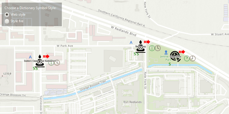
Use the radio buttons to toggle between the dictionary symbols from the web style and style file. Pan and zoom around the map to see the symbology from the chosen dictionary symbol style. The web style and style file are slightly different to each other to give a visual indication of the switch between the two.
How it works
- Create a
PortalItem, referring to aPortaland the item ID of the web style. - Based on the style selected:
- If the web style toggle has been selected, create a new
DictionarySymbolStylefrom the portal item usingnew DictionarySymbolStyle(portalItem), and load it - If the file style toggle has been selected, create a new
DictionarySymbolStyleusingDictionarySymbolStyle.createFromFile(stylxFile.getAbsolutePath())
- Create a new
DictionaryRenderer, providing the dictionary symbol style. - Apply the dictionary renderer to a feature layer using
featureLayer.setRenderer(dictionaryRenderer). - Add the feature layer to the map's operational layers using
getOperationalLayers().add(featureLayer).
Relevant API
- DictionaryRenderer
- DictionarySymbolStyle
- Portal
- PortalItem
About the data
The data used in this sample is from a feature layer showing a subset of restaurants in Redlands, CA hosted as a feature service with attributes for rating, style, health score, and open hours.
The feature layer is symbolized using a dictionary renderer that displays a single symbol for all of these variables. The renderer uses symbols from a custom restaurant dictionary style created from a stylx file and a web style, available as items from ArcGIS Online, to show unique symbols based on several feature attributes. The symbols it contains were created using ArcGIS Pro. The logic used to apply the symbols comes from an Arcade script embedded in the stylx file (which is a SQLite database), along with a JSON string that defines expected attribute names and configuration properties.
Additional information
For information about creating your own custom dictionary style, see the open source dictionary renderer toolkit on GitHub.
Tags
dictionary, military, portal, portal item, renderer, style, stylx, unique value, visualization
Sample Code
/*
* Copyright 2019 Esri
*
* Licensed under the Apache License, Version 2.0 (the "License");
* you may not use this file except in compliance with the License.
* You may obtain a copy of the License at
*
* http://www.apache.org/licenses/LICENSE-2.0
*
* Unless required by applicable law or agreed to in writing, software
* distributed under the License is distributed on an "AS IS" BASIS,
* WITHOUT WARRANTIES OR CONDITIONS OF ANY KIND, either express or implied.
* See the License for the specific language governing permissions and
* limitations under the License.
*/
package com.esri.samples.custom_dictionary_style;
import javafx.application.Application;
import javafx.geometry.Insets;
import javafx.geometry.Pos;
import javafx.scene.Scene;
import javafx.scene.control.Alert;
import javafx.scene.control.Label;
import javafx.scene.control.ProgressIndicator;
import javafx.scene.control.RadioButton;
import javafx.scene.control.ToggleGroup;
import javafx.scene.layout.Background;
import javafx.scene.layout.BackgroundFill;
import javafx.scene.layout.CornerRadii;
import javafx.scene.layout.StackPane;
import javafx.scene.layout.VBox;
import javafx.scene.paint.Paint;
import javafx.stage.Stage;
import com.esri.arcgisruntime.ArcGISRuntimeEnvironment;
import com.esri.arcgisruntime.data.ServiceFeatureTable;
import com.esri.arcgisruntime.geometry.Point;
import com.esri.arcgisruntime.layers.FeatureLayer;
import com.esri.arcgisruntime.loadable.LoadStatus;
import com.esri.arcgisruntime.mapping.ArcGISMap;
import com.esri.arcgisruntime.mapping.BasemapStyle;
import com.esri.arcgisruntime.mapping.Viewpoint;
import com.esri.arcgisruntime.mapping.view.MapView;
import com.esri.arcgisruntime.portal.Portal;
import com.esri.arcgisruntime.portal.PortalItem;
import com.esri.arcgisruntime.symbology.DictionaryRenderer;
import com.esri.arcgisruntime.symbology.DictionarySymbolStyle;
import com.esri.arcgisruntime.symbology.Renderer;
import java.io.File;
import java.util.HashMap;
public class CustomDictionaryStyleSample extends Application {
private MapView mapView;
private DictionarySymbolStyle dictSymbStyleFromPortal; // keep loadables in scope to avoid garbage collection
private DictionaryRenderer webStyleDictionaryRenderer;
private VBox controlsVBox;
private ToggleGroup toggleGroup;
private RadioButton webStyleButton;
private RadioButton fileStyleButton;
private ProgressIndicator progressIndicator;
@Override
public void start(Stage stage) {
try {
// create stack pane and application scene
StackPane stackPane = new StackPane();
Scene scene = new Scene(stackPane);
scene.getStylesheets().add(getClass().getResource("/custom_dictionary_style/style.css").toExternalForm());
// set title, size, and add scene to stage
stage.setTitle("Custom Dictionary Style Sample");
stage.setWidth(800);
stage.setHeight(700);
stage.setScene(scene);
stage.show();
// authentication with an API key or named user is required to access basemaps and other location services
String yourAPIKey = System.getProperty("apiKey");
ArcGISRuntimeEnvironment.setApiKey(yourAPIKey);
// create a map with the topographic basemap style
ArcGISMap map = new ArcGISMap(BasemapStyle.ARCGIS_TOPOGRAPHIC);
// create a map view and set the map to it
mapView = new MapView();
mapView.setMap(map);
// set the initial viewpoint to the Esri Redlands campus
map.setInitialViewpoint(
new Viewpoint(new Point(-13046305, 4036698.1412000, map.getSpatialReference()), 5000));
// set up the UI
setupUI();
// enable UI interactions once the map has loaded
map.addDoneLoadingListener(() -> {
if (map.getLoadStatus() == LoadStatus.LOADED) {
controlsVBox.setDisable(false);
} else {
new Alert(Alert.AlertType.ERROR, "Map failed to load").show();
}
});
// create a stylex file from a local location
File stylxFile = new File(System.getProperty("data.dir"), "./samples-data/stylx/Restaurant.stylx");
// create a dictionary symbol style from the stylx file, and create a new dictionary renderer from it
DictionarySymbolStyle dictSymbStyleFromFile = DictionarySymbolStyle.createFromFile(stylxFile.getAbsolutePath());
DictionaryRenderer dictRendFromFile = new DictionaryRenderer(dictSymbStyleFromFile);
// set the renderer from the style file to the UI
fileStyleButton.setUserData(dictRendFromFile);
// create a portal item using the portal and the item id of the dictionary web style
Portal portal = new Portal("https://arcgisruntime.maps.arcgis.com");
PortalItem portalItem = new PortalItem(portal, "adee951477014ec68d7cf0ea0579c800");
// map the input fields in the feature layer to the dictionary symbol style's expected fields for symbols and text
HashMap<String, String> fieldMap = new HashMap<>();
fieldMap.put("healthgrade", "Inspection");
// create a new dictionary symbol style from the web style in the portal item
dictSymbStyleFromPortal = new DictionarySymbolStyle(portalItem);
// load the symbol dictionary
dictSymbStyleFromPortal.loadAsync();
dictSymbStyleFromPortal.addDoneLoadingListener(() -> {
if (dictSymbStyleFromPortal.getLoadStatus() == LoadStatus.LOADED) {
// enable the UI
controlsVBox.setDisable(false);
// create a dictionary renderer with the dictionary symbol style,
// and manually map the feature layer's attribute name to those expected by the dictionary symbol style
webStyleDictionaryRenderer = new DictionaryRenderer(dictSymbStyleFromPortal, fieldMap, fieldMap);
// set the renderer from web style to the UI
webStyleButton.setUserData(webStyleDictionaryRenderer);
progressIndicator.setVisible(false);
} else {
new Alert(Alert.AlertType.ERROR, "Dictionary symbol style failed to load!").show();
}
});
// create a service feature table and create a feature layer from it (restaurant data)
var serviceFeatureTable =
new ServiceFeatureTable("https://services2.arcgis.com/ZQgQTuoyBrtmoGdP/ArcGIS/rest/services/Redlands_Restaurants/FeatureServer/0");
FeatureLayer restaurantLayer = new FeatureLayer(serviceFeatureTable);
map.getOperationalLayers().add(restaurantLayer);
// add a listener to the radio button toggle group to change the dictionary renderer
toggleGroup.selectedToggleProperty().addListener((observable -> {
if (toggleGroup.getSelectedToggle() != null) {
// set the chosen dictionary renderer to the feature layer
restaurantLayer.setRenderer((Renderer) toggleGroup.getSelectedToggle().getUserData());
}
})
);
// show the style file symbols by default
toggleGroup.selectToggle(fileStyleButton);
// add the control panel, map view, and progress indicator to the stack pane
stackPane.getChildren().addAll(mapView, controlsVBox, progressIndicator);
StackPane.setAlignment(controlsVBox, Pos.TOP_LEFT);
StackPane.setAlignment(progressIndicator, Pos.CENTER);
StackPane.setMargin(controlsVBox, new Insets(10, 0, 0, 10));
} catch (Exception e) {
e.printStackTrace();
}
}
/**
* Sets up control panel with radio buttons to toggle between the dictionary symbol styles.
*/
public void setupUI() {
// create a label
Label symbolStyleLabel = new Label("Choose a Dictionary Symbol Style:");
// create radio buttons for toggling between the web and file styles
webStyleButton = new RadioButton("Web style");
fileStyleButton = new RadioButton("Local style file");
// set the radio buttons to a toggle group
toggleGroup = new ToggleGroup();
toggleGroup.getToggles().addAll(webStyleButton, fileStyleButton);
// show progress indicator when the dictionary symbol styles are loading
progressIndicator = new ProgressIndicator();
progressIndicator.setMaxWidth(30);
progressIndicator.setVisible(true);
// create a control panel
controlsVBox = new VBox(6);
controlsVBox.setBackground(new Background(new BackgroundFill(Paint.valueOf("rgba(0,0,0,0.3)"), CornerRadii.EMPTY,
Insets.EMPTY)));
controlsVBox.setPadding(new Insets(10.0));
controlsVBox.setMaxSize(210, 80);
controlsVBox.getStyleClass().add("panel-region");
controlsVBox.setDisable(true);
// add the label and radio buttons to the control panel
controlsVBox.getChildren().addAll(symbolStyleLabel, webStyleButton, fileStyleButton);
}
/**
* Stops and releases all resources used in application.
*/
@Override
public void stop() {
// release resources when the application closes
if (mapView != null) {
mapView.dispose();
}
}
/**
* Opens and runs application.
*
* @param args arguments passed to this application
*/
public static void main(String[] args) {
Application.launch(args);
}
}