Simplify a polygon with a self-intersecting geometry.
Use case
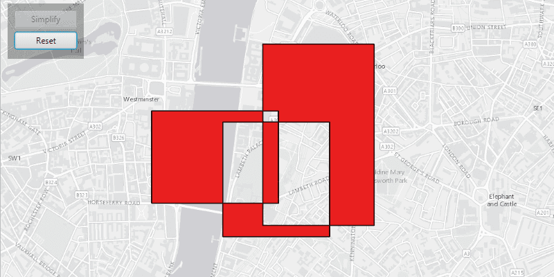
A user may draw a polygon which is self-intersecting or contains incorrect ring orientations. The geometry must be simplified before it can be saved to a geodatabase.
How to use the sample
Click the 'Simplify' button to simplify the geometry. Click 'Reset' to reset to the original geometry.
How it works
- Check if the polygon geometry needs to be simplified using
GeometryEngine.isSimple(Geometry). - Simplify the polygon's geometry using
GeometryEngine.simplify(Geometry).
Relevant API
- Geometry
- GeometryEngine
Additional information
The concept of topological simplicity is different than geometry generalization, where points are removed from polygons or lines to create a more generalized result while preserving overall shape. See the 'Densify and Generalize' sample for comparison.
Tags
geometry, polygon, simplify, spatial operations, topology
Sample Code
GeometryEngineSimplifySample.java
/*
* Copyright 2017 Esri.
*
* Licensed under the Apache License, Version 2.0 (the "License"); you may not
* use this file except in compliance with the License. You may obtain a copy of
* the License at
*
* http://www.apache.org/licenses/LICENSE-2.0
*
* Unless required by applicable law or agreed to in writing, software
* distributed under the License is distributed on an "AS IS" BASIS, WITHOUT
* WARRANTIES OR CONDITIONS OF ANY KIND, either express or implied. See the
* License for the specific language governing permissions and limitations under
* the License.
*/
package com.esri.samples.geometry_engine_simplify;
import javafx.application.Application;
import javafx.geometry.Insets;
import javafx.geometry.Pos;
import javafx.scene.Scene;
import javafx.scene.control.Alert;
import javafx.scene.control.Button;
import javafx.scene.layout.Background;
import javafx.scene.layout.BackgroundFill;
import javafx.scene.layout.CornerRadii;
import javafx.scene.layout.StackPane;
import javafx.scene.layout.VBox;
import javafx.scene.paint.Color;
import javafx.scene.paint.Paint;
import javafx.stage.Stage;
import com.esri.arcgisruntime.ArcGISRuntimeEnvironment;
import com.esri.arcgisruntime.geometry.Geometry;
import com.esri.arcgisruntime.geometry.GeometryEngine;
import com.esri.arcgisruntime.geometry.Part;
import com.esri.arcgisruntime.geometry.PartCollection;
import com.esri.arcgisruntime.geometry.Point;
import com.esri.arcgisruntime.geometry.PointCollection;
import com.esri.arcgisruntime.geometry.Polygon;
import com.esri.arcgisruntime.geometry.SpatialReferences;
import com.esri.arcgisruntime.loadable.LoadStatus;
import com.esri.arcgisruntime.mapping.ArcGISMap;
import com.esri.arcgisruntime.mapping.BasemapStyle;
import com.esri.arcgisruntime.mapping.view.Graphic;
import com.esri.arcgisruntime.mapping.view.GraphicsOverlay;
import com.esri.arcgisruntime.mapping.view.MapView;
import com.esri.arcgisruntime.symbology.SimpleFillSymbol;
import com.esri.arcgisruntime.symbology.SimpleLineSymbol;
public class GeometryEngineSimplifySample extends Application {
private ArcGISMap map; // keep loadable in scope to avoid garbage collection
private GraphicsOverlay resultGeomOverlay;
private Graphic polygon;
private MapView mapView;
// simple black line symbol
private final SimpleLineSymbol line = new SimpleLineSymbol(SimpleLineSymbol.Style.SOLID, Color.BLACK, 1);
@Override
public void start(Stage stage) {
try {
// create stack pane and application scene
StackPane stackPane = new StackPane();
Scene scene = new Scene(stackPane);
scene.getStylesheets().add(getClass().getResource("/geometry_engine_simplify/style.css").toExternalForm());
// set title, size, and add scene to stage
stage.setTitle("Geometry Engine Simplify Sample");
stage.setWidth(800);
stage.setHeight(700);
stage.setScene(scene);
stage.show();
// authentication with an API key or named user is required to access basemaps and other location services
String yourAPIKey = System.getProperty("apiKey");
ArcGISRuntimeEnvironment.setApiKey(yourAPIKey);
// create a control panel
VBox controlsVBox = new VBox(6);
controlsVBox.setBackground(new Background(new BackgroundFill(Paint.valueOf("rgba(0,0,0,0.3)"), CornerRadii.EMPTY,
Insets.EMPTY)));
controlsVBox.setPadding(new Insets(10.0));
controlsVBox.setMaxSize(110, 80);
controlsVBox.getStyleClass().add("panel-region");
// create simplify button
Button simplifyButton = new Button("Simplify");
simplifyButton.setMaxWidth(Double.MAX_VALUE);
simplifyButton.setDisable(true);
// create reset button
Button resetButton = new Button("Reset");
resetButton.setMaxWidth(Double.MAX_VALUE);
resetButton.setDisable(true);
// perform the simplify geometry operation
simplifyButton.setOnAction(e -> {
// check if the geometry needs to be simplified
if (!GeometryEngine.isSimple(polygon.getGeometry())) {
// simplify the geometry
Geometry resultPolygon = GeometryEngine.simplify(polygon.getGeometry());
// update result as a red graphic
SimpleFillSymbol redSymbol = new SimpleFillSymbol(SimpleFillSymbol.Style.SOLID, Color.RED, line);
resultGeomOverlay.getGraphics().add(new Graphic(resultPolygon, redSymbol));
resetButton.setDisable(false);
simplifyButton.setDisable(true);
}
});
// clear result layer
resetButton.setOnAction(e -> {
resultGeomOverlay.getGraphics().clear();
simplifyButton.setDisable(false);
resetButton.setDisable(true);
});
// add buttons to the control panel
controlsVBox.getChildren().addAll(simplifyButton, resetButton);
// create a map with the light gray basemap style
map = new ArcGISMap(BasemapStyle.ARCGIS_LIGHT_GRAY);
// enable geometry operations when the map is done loading
map.addDoneLoadingListener(() -> {
if (map.getLoadStatus() == LoadStatus.LOADED) {
simplifyButton.setDisable(false);
} else {
Alert alert = new Alert(Alert.AlertType.ERROR, "Map Failed to Load!");
alert.show();
}
});
// create a map view and set the map to it
mapView = new MapView();
mapView.setMap(map);
// set a viewpoint on the map view, centered on London
mapView.setViewpointCenterAsync(new Point(-13500, 6710327, SpatialReferences.getWebMercator()), 25000);
// create geometry layers
GraphicsOverlay geomOverlay = new GraphicsOverlay();
mapView.getGraphicsOverlays().add(geomOverlay);
resultGeomOverlay = new GraphicsOverlay();
mapView.getGraphicsOverlays().add(resultGeomOverlay);
// create sample polygon
createPolygon();
geomOverlay.getGraphics().add(polygon);
// add the map view and control panel to stack pane
stackPane.getChildren().addAll(mapView, controlsVBox);
StackPane.setAlignment(controlsVBox, Pos.TOP_LEFT);
StackPane.setMargin(controlsVBox, new Insets(10, 0, 0, 10));
} catch (Exception e) {
// on any error, display the stack trace
e.printStackTrace();
}
}
/**
* Creates the polygon.
*/
private void createPolygon() {
// part one
PointCollection partSegmentCollectionOne = new PointCollection(SpatialReferences.getWebMercator());
partSegmentCollectionOne.add(new Point(-13020, 6710130));
partSegmentCollectionOne.add(new Point(-14160, 6710130));
partSegmentCollectionOne.add(new Point(-14160, 6709300));
partSegmentCollectionOne.add(new Point(-13020, 6709300));
partSegmentCollectionOne.add(new Point(-13020, 6710130));
Part partOne = new Part(partSegmentCollectionOne);
// part two
PointCollection partSegmentCollectionTwo = new PointCollection(SpatialReferences.getWebMercator());
partSegmentCollectionTwo.add(new Point(-12160, 6710730));
partSegmentCollectionTwo.add(new Point(-13160, 6710730));
partSegmentCollectionTwo.add(new Point(-13160, 6709100));
partSegmentCollectionTwo.add(new Point(-12160, 6709100));
partSegmentCollectionTwo.add(new Point(-12160, 6710730));
Part partTwo = new Part(partSegmentCollectionTwo);
// part three
PointCollection partSegmentCollectionThree = new PointCollection(SpatialReferences.getWebMercator());
partSegmentCollectionThree.add(new Point(-12560, 6710030));
partSegmentCollectionThree.add(new Point(-13520, 6710030));
partSegmentCollectionThree.add(new Point(-13520, 6709000));
partSegmentCollectionThree.add(new Point(-12560, 6709000));
partSegmentCollectionThree.add(new Point(-12560, 6710030));
Part partThree = new Part(partSegmentCollectionThree);
PartCollection polygonParts = new PartCollection(partOne);
polygonParts.add(partTwo);
polygonParts.add(partThree);
// transparent fill
SimpleFillSymbol fillSymbol = new SimpleFillSymbol(SimpleFillSymbol.Style.SOLID, Color.TRANSPARENT, line);
polygon = new Graphic(new Polygon(polygonParts), fillSymbol);
}
/**
* Stops and releases all resources used in application.
*/
@Override
public void stop() {
if (mapView != null) {
mapView.dispose();
}
}
/**
* Opens and runs application.
*
* @param args arguments passed to this application
*/
public static void main(String[] args) {
Application.launch(args);
}
}