Use annotation sublayers to gain finer control of annotation layer subtypes.
Use case
Annotation, which differs from labels by having a fixed place and size, is typically only relevant at particular scales. Annotation sublayers allow for finer control of annotation by allowing properties (like visibility in the map and legend) to be set and others to be read (like name) on subtypes of an annotation layer.
An annotation dataset which marks valves as "Opened" or "Closed", might be set to display the "Closed" valves over a broader range of scales than the "Opened" valves, if the "Closed" data is considered more relevant by the map's author. Regardless, the user can be given a manual option to set visibility of annotation sublayers on and off, if required.
How to use the sample
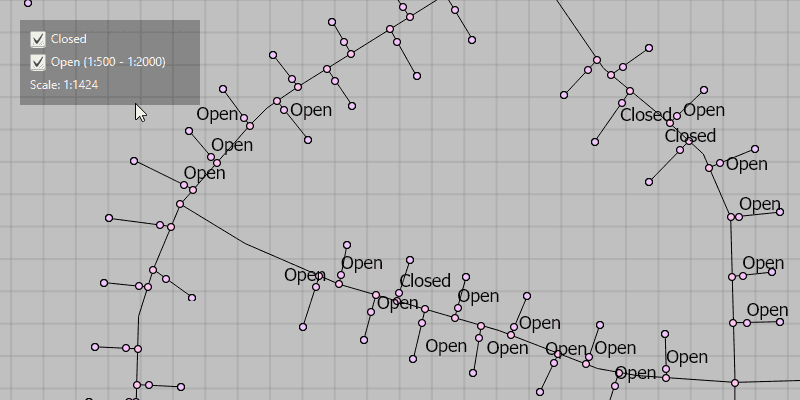
Start the sample and take note of the visibility of the annotation. Zoom in and out to see the annotation turn on and off based on scale ranges set on the data.
Use the checkboxes to manually set "Open" and "Closed" annotation sublayers visibility to on or off.
How it works
- Load a
MobileMapPackagethat containsAnnotationSublayer. - Get the sublayers from the map package's layers by calling
Layer.getSubLayerContents.get(i). - You can toggle the visibility of each sublayer manually using
.setVisible(). - To determine if a sublayer is visible at the current scale of the
MapView, usesublayer.isVisibleAtScale(), by passing in the map's current scale.
Relevant API
- AnnotationLayer
- AnnotationSublayer
- LayerContent
About the data
The scale ranges were set by the map's author using ArcGIS Pro:
- The "Open" annotation sublayer has its maximum scale set to 1:500 and its minimum scale set to 1:2000.
- The "Closed" annotation sublayer has no minimum or maximum scales set, so will be drawn at all scales.
Tags
annotation, scale, text, utilities, visualization
Sample Code
/*
* Copyright 2019 Esri.
*
* Licensed under the Apache License, Version 2.0 (the "License"); you may not
* use this file except in compliance with the License. You may obtain a copy of
* the License at
*
* http://www.apache.org/licenses/LICENSE-2.0
*
* Unless required by applicable law or agreed to in writing, software
* distributed under the License is distributed on an "AS IS" BASIS, WITHOUT
* WARRANTIES OR CONDITIONS OF ANY KIND, either express or implied. See the
* License for the specific language governing permissions and limitations under
* the License.
*/
package com.esri.samples.control_annotation_sublayer_visibility;
import javafx.application.Application;
import javafx.beans.binding.Bindings;
import javafx.geometry.Insets;
import javafx.geometry.Pos;
import javafx.scene.Scene;
import javafx.scene.control.Alert;
import javafx.scene.control.CheckBox;
import javafx.scene.control.Label;
import javafx.scene.layout.Background;
import javafx.scene.layout.BackgroundFill;
import javafx.scene.layout.CornerRadii;
import javafx.scene.layout.StackPane;
import javafx.scene.layout.VBox;
import javafx.scene.paint.Color;
import javafx.scene.paint.Paint;
import javafx.stage.Stage;
import com.esri.arcgisruntime.layers.AnnotationLayer;
import com.esri.arcgisruntime.layers.AnnotationSublayer;
import com.esri.arcgisruntime.layers.Layer;
import com.esri.arcgisruntime.loadable.LoadStatus;
import com.esri.arcgisruntime.mapping.MobileMapPackage;
import com.esri.arcgisruntime.mapping.view.MapView;
import java.io.File;
public class ControlAnnotationSublayerVisibilitySample extends Application {
private MapView mapView;
private MobileMapPackage mobileMapPackage;
@Override
public void start(Stage stage) {
try {
// create stack pane and application scene
StackPane stackPane = new StackPane();
Scene scene = new Scene(stackPane);
scene.getStylesheets().add(getClass().getResource("/control_annotation_sublayer_visibility/style.css").toExternalForm());
// set title, size, and add scene to stage
stage.setTitle("Control Annotation Sublayer Visibility");
stage.setWidth(800);
stage.setHeight(700);
stage.setScene(scene);
stage.show();
// create a map view
mapView = new MapView();
// create checkboxes for toggling the sublayer visibility manually
CheckBox closedSublayerCheckbox = new CheckBox();
closedSublayerCheckbox.setSelected(true);
closedSublayerCheckbox.setTextFill(Color.WHITE);
CheckBox openSublayerCheckbox = new CheckBox();
openSublayerCheckbox.setSelected(true);
openSublayerCheckbox.setTextFill(Color.WHITE);
// create a control panel and label for the checkboxes
VBox controlsVBox = new VBox(6);
controlsVBox.getStyleClass().add("panel-region");
controlsVBox.setBackground(new Background(new BackgroundFill(Paint.valueOf("rgba(0,0,0,0.3)"), CornerRadii.EMPTY,
Insets.EMPTY)));
controlsVBox.setPadding(new Insets(10.0));
controlsVBox.setMaxSize(180, 85);
// show current map scale in a label within the control panel
Label currentMapScaleLabel = new Label();
// listen for map scale changes and update the label
mapView.mapScaleProperty().addListener((observable, oldValue, newValue) ->
currentMapScaleLabel.setText("Scale: 1:" + Math.round((double) newValue)));
// add checkboxes and label to the control panel
controlsVBox.getChildren().addAll(closedSublayerCheckbox, openSublayerCheckbox, currentMapScaleLabel);
// load the mobile map package
File mmpkFile = new File(System.getProperty("data.dir"), "./samples-data/mmpk/GasDeviceAnno.mmpk");
mobileMapPackage = new MobileMapPackage(mmpkFile.getAbsolutePath());
mobileMapPackage.loadAsync();
mobileMapPackage.addDoneLoadingListener(() -> {
if (mobileMapPackage.getLoadStatus() == LoadStatus.LOADED && !mobileMapPackage.getMaps().isEmpty()) {
// set the mobile map package's map to the map view
mapView.setMap(mobileMapPackage.getMaps().get(0));
// find the annotation layer within the map
for (Layer layer : mapView.getMap().getOperationalLayers()) {
if (layer instanceof AnnotationLayer) {
// load the annotation layer
layer.loadAsync();
layer.addDoneLoadingListener(() -> {
if (layer.getLoadStatus() == LoadStatus.LOADED) {
// get annotation sublayer name from sublayer content
AnnotationSublayer closedSublayer = (AnnotationSublayer) layer.getSubLayerContents().get(0);
AnnotationSublayer openSublayer = (AnnotationSublayer) layer.getSubLayerContents().get(1);
// set the layer name for the checkboxes
closedSublayerCheckbox.setText(closedSublayer.getName());
openSublayerCheckbox.setText(String.format("%s (1:%d - 1:%d)", openSublayer.getName(), Math.round(openSublayer.getMaxScale()), Math.round(openSublayer.getMinScale())));
// toggle annotation sublayer visibility on check
closedSublayerCheckbox.setOnAction(event -> closedSublayer.setVisible(closedSublayerCheckbox.isSelected()));
openSublayerCheckbox.setOnAction(event -> openSublayer.setVisible(openSublayerCheckbox.isSelected()));
// bind the checkbox disable property to its map scale visibility
var mapScaleProperty = mapView.mapScaleProperty();
openSublayerCheckbox.disableProperty().bind(Bindings.createBooleanBinding(() ->
!openSublayer.isVisibleAtScale(mapScaleProperty.get()), mapScaleProperty));
} else {
new Alert(Alert.AlertType.ERROR, "Error loading Annotation Layer " + layer.getName()).show();
}
});
}
}
} else {
new Alert(Alert.AlertType.ERROR, "Mobile Map Package failed to load.").show();
}
});
// add map view and label to stack pane
stackPane.getChildren().addAll(mapView, controlsVBox);
StackPane.setAlignment(controlsVBox, Pos.TOP_LEFT);
StackPane.setMargin(controlsVBox, new Insets(20, 0, 0, 20));
} catch (Exception e) {
// on any error, print the stack trace
e.printStackTrace();
}
}
/**
* Stops and releases all resources used in application.
*/
@Override
public void stop() {
// release resources when the application closes
if (mapView != null) {
mapView.dispose();
}
}
/**
* Opens and runs application.
*
* @param args arguments passed to this application
*/
public static void main(String[] args) {
Application.launch(args);
}
}