Generate multiple individual buffers or a single unioned buffer around multiple points.
Use case
Creating buffers is a core concept in GIS proximity analysis that allows you to visualize and locate geographic features contained within a set distance of a feature. For example, consider an area where wind turbines are proposed. It has been determined that each turbine should be located at least 2 km away from residential premises due to noise pollution regulations, and a proximity analysis is therefore required. The first step would be to generate 2 km buffer polygons around all proposed turbines. As the buffer polygons may overlap for each turbine, unioning the result would produce a single graphic result with a neater visual output. If any premises are located within 2 km of a turbine, that turbine would be in breach of planning regulations.
How to use the sample
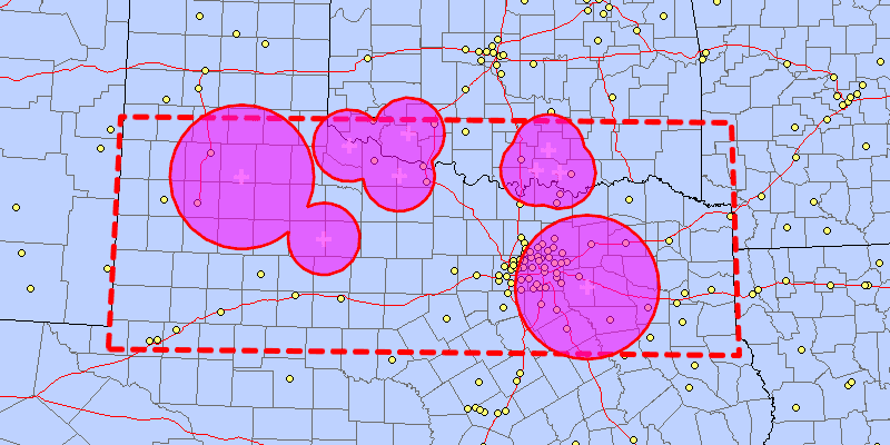
Click on the map to add points. Click the "Create Buffer(s)" button to draw buffer(s) around the points (the size of the buffer is determined by the value entered by the user). Check the check box if you want the result to union (combine) the buffers. Click the "Clear" button to start over. The red dashed envelope shows the area where you can expect reasonable results for planar buffer operations with the North Central Texas State Plane spatial reference.
How it works
- Use
GeometryEngine.buffer(points, distances, union)to create aPolygon. The parameterpointsare the points to buffer around,distancesare the buffer distances for each point (in meters) andunionis a boolean for whether the results should be unioned. - Add the resulting polygons (if not unioned) or single polygon (if unioned) to the map's
GraphicsOverlayas aGraphic.
Relevant API
- GeometryEngine
- SpatialReference
Additional information
The properties of the underlying projection determine the accuracy of buffer polygons in a given area. Planar buffers work well when analyzing distances around features that are concentrated in a relatively small area in a projected coordinate system. Inaccurate buffers could still be created by buffering points inside the spatial reference's envelope with distances that move it outside the envelope. On the other hand, geodesic buffers consider the curved shape of the Earth's surface and provide more accurate buffer offsets for features that are more dispersed (i.e., cover multiple UTM zones, large regions, or even the whole globe). See the "Buffer" sample for an example of a geodesic buffer.
For more information about using buffer analysis, see the topic How Buffer (Analysis) works in the ArcGIS Pro documentation.
Tags
analysis, buffer, geometry, planar
Sample Code
/*
* Copyright 2018 Esri.
*
* Licensed under the Apache License, Version 2.0 (the "License"); you may not
* use this file except in compliance with the License. You may obtain a copy of
* the License at
*
* http://www.apache.org/licenses/LICENSE-2.0
*
* Unless required by applicable law or agreed to in writing, software
* distributed under the License is distributed on an "AS IS" BASIS, WITHOUT
* WARRANTIES OR CONDITIONS OF ANY KIND, either express or implied. See the
* License for the specific language governing permissions and limitations under
* the License.
*/
package com.esri.samples.buffer_list;
import java.util.ArrayList;
import java.util.Arrays;
import java.util.List;
import javafx.application.Application;
import javafx.geometry.Insets;
import javafx.geometry.Point2D;
import javafx.geometry.Pos;
import javafx.scene.Scene;
import javafx.scene.control.Alert;
import javafx.scene.control.Button;
import javafx.scene.control.CheckBox;
import javafx.scene.control.Spinner;
import javafx.scene.input.MouseButton;
import javafx.scene.layout.Background;
import javafx.scene.layout.BackgroundFill;
import javafx.scene.layout.CornerRadii;
import javafx.scene.layout.StackPane;
import javafx.scene.layout.VBox;
import javafx.scene.paint.Color;
import javafx.scene.paint.Paint;
import javafx.stage.Stage;
import com.esri.arcgisruntime.geometry.Geometry;
import com.esri.arcgisruntime.geometry.GeometryEngine;
import com.esri.arcgisruntime.geometry.LinearUnit;
import com.esri.arcgisruntime.geometry.LinearUnitId;
import com.esri.arcgisruntime.geometry.Point;
import com.esri.arcgisruntime.geometry.PointCollection;
import com.esri.arcgisruntime.geometry.Polygon;
import com.esri.arcgisruntime.geometry.SpatialReference;
import com.esri.arcgisruntime.geometry.SpatialReferences;
import com.esri.arcgisruntime.layers.ArcGISMapImageLayer;
import com.esri.arcgisruntime.loadable.LoadStatus;
import com.esri.arcgisruntime.mapping.ArcGISMap;
import com.esri.arcgisruntime.mapping.Viewpoint;
import com.esri.arcgisruntime.mapping.view.Graphic;
import com.esri.arcgisruntime.mapping.view.GraphicsOverlay;
import com.esri.arcgisruntime.mapping.view.MapView;
import com.esri.arcgisruntime.symbology.SimpleFillSymbol;
import com.esri.arcgisruntime.symbology.SimpleLineSymbol;
import com.esri.arcgisruntime.symbology.SimpleMarkerSymbol;
public class BufferListSample extends Application {
private MapView mapView;
@Override
public void start(Stage stage) {
try {
// create stack pane and application scene
StackPane stackPane = new StackPane();
Scene scene = new Scene(stackPane);
// set title, size, and add scene to stage
stage.setTitle("Buffer List Sample");
stage.setWidth(800);
stage.setHeight(700);
stage.setScene(scene);
stage.show();
SpatialReference statePlaneNorthCentralTexas = SpatialReference.create(32038);
// show a box where the spatial reference used is valid for planar buffers
List<Point> boundaryPoints = Arrays.asList(
new Point(-103.070, 31.720, SpatialReferences.getWgs84()),
new Point(-103.070, 34.580, SpatialReferences.getWgs84()),
new Point(-94.000, 34.580, SpatialReferences.getWgs84()),
new Point(-94.00, 31.720, SpatialReferences.getWgs84())
);
Polygon boundaryPolygon = (Polygon) GeometryEngine.project(new Polygon(new PointCollection(boundaryPoints)), statePlaneNorthCentralTexas);
// create a blank map with a spatial reference and set an initial viewpoint
ArcGISMap map = new ArcGISMap(statePlaneNorthCentralTexas);
map.setInitialViewpoint(new Viewpoint(boundaryPolygon.getExtent()));
// create an image layer from a service URL (counties, cities, and highways)
ArcGISMapImageLayer mapImageLayer = new ArcGISMapImageLayer("https://sampleserver6.arcgisonline.com/arcgis/rest/services/USA/MapServer");
// add the image layer to the map's base layers
map.getBasemap().getBaseLayers().add(mapImageLayer);
// create a map view and set the map to it
mapView = new MapView();
mapView.setMap(map);
// show alert if layer fails to load
mapImageLayer.addDoneLoadingListener(() -> {
if (mapImageLayer.getLoadStatus() != LoadStatus.LOADED) {
new Alert(Alert.AlertType.ERROR, "Error loading ArcGIS Map Image Layer.").show();
}
});
// create a graphics overlay to show the spatial reference's valid area
GraphicsOverlay boundaryGraphicsOverlay = new GraphicsOverlay();
mapView.getGraphicsOverlays().add(boundaryGraphicsOverlay);
SimpleLineSymbol lineSymbol = new SimpleLineSymbol(SimpleLineSymbol.Style.DASH, Color.RED, 5);
Graphic boundaryGraphic = new Graphic(boundaryPolygon, lineSymbol);
boundaryGraphicsOverlay.getGraphics().add(boundaryGraphic);
GraphicsOverlay bufferGraphicsOverlay = new GraphicsOverlay();
mapView.getGraphicsOverlays().add(bufferGraphicsOverlay);
// create a white cross marker symbol to show where the user clicked
final SimpleMarkerSymbol markerSymbol = new SimpleMarkerSymbol(SimpleMarkerSymbol.Style.CROSS, Color.WHITE, 14);
// create a semi-transparent
final SimpleFillSymbol fillSymbol = new SimpleFillSymbol(SimpleFillSymbol.Style.SOLID, Color.web("fuchsia", 0.5),
new SimpleLineSymbol(SimpleLineSymbol.Style.SOLID, Color.RED, 3));
// create a box to hold the input controls
VBox controlsVBox = new VBox(6);
controlsVBox.setBackground(new Background(new BackgroundFill(Paint.valueOf("rgba(0,0,0,0.3)"), CornerRadii.EMPTY,
Insets.EMPTY)));
controlsVBox.setPadding(new Insets(10.0));
controlsVBox.setMaxSize(200, 150);
controlsVBox.getStyleClass().add("panel-region");
// create a spinner to set the buffer size (in miles)
Spinner<Integer> distanceSpinner = new Spinner<>(0, 300, 100);
distanceSpinner.setEditable(true);
controlsVBox.getChildren().add(distanceSpinner);
// set up units to convert from miles to meters
final LinearUnit miles = new LinearUnit(LinearUnitId.MILES);
final LinearUnit meters = new LinearUnit(LinearUnitId.METERS);
// create a checkbox to choose whether to union the buffers into one geometry
CheckBox unionCheckBox = new CheckBox("Union the buffers");
controlsVBox.getChildren().add(unionCheckBox);
// create a button to create the buffer(s)
Button createButton = new Button("Create Buffer(s)");
controlsVBox.getChildren().add(createButton);
// create a button to clear the buffer(s)
Button clearButton = new Button("Clear");
controlsVBox.getChildren().add(clearButton);
// when the user clicks the map, save the clicked location, along with the current distance value
List<Geometry> geometries = new ArrayList<>();
List<Double> distances = new ArrayList<>();
mapView.setOnMouseClicked(e -> {
if (e.isStillSincePress() && e.getButton() == MouseButton.PRIMARY) {
Point2D point2D = new Point2D(e.getX(), e.getY());
Point point = mapView.screenToLocation(point2D);
if (GeometryEngine.contains(boundaryPolygon, point)) {
geometries.add(point);
double distance = miles.convertTo(meters, distanceSpinner.getValue());
distances.add(distance);
// add a marker where the user clicked
Graphic clickedMarker = new Graphic(point, markerSymbol);
bufferGraphicsOverlay.getGraphics().add(clickedMarker);
} else {
Alert alert = new Alert(Alert.AlertType.WARNING, "Location is not valid to buffer using the defined spatial reference.");
alert.initOwner(mapView.getScene().getWindow());
alert.show();
}
}
});
// draw the buffer(s) when the button is clicked
createButton.setOnAction(e -> {
// if the buffers are unioned, only one polygon is returned
if (!geometries.isEmpty() && !distances.isEmpty()) {
List<Polygon> buffers = GeometryEngine.buffer(geometries, distances, unionCheckBox.isSelected());
buffers.forEach(bufferGeometry -> {
Graphic bufferGraphic = new Graphic(bufferGeometry, fillSymbol);
bufferGraphicsOverlay.getGraphics().add(bufferGraphic);
});
}
});
clearButton.setOnAction(e -> {
bufferGraphicsOverlay.getGraphics().clear();
geometries.clear();
distances.clear();
});
// add the map view to the stack pane
stackPane.getChildren().addAll(mapView, controlsVBox);
StackPane.setAlignment(controlsVBox, Pos.TOP_LEFT);
StackPane.setMargin(controlsVBox, new Insets(10, 0, 0, 10));
} catch (Exception e) {
// on any error, display the stack trace.
e.printStackTrace();
}
}
/**
* Stops and releases all resources used in application.
*/
@Override
public void stop() {
if (mapView != null) {
mapView.dispose();
}
}
/**
* Opens and runs application.
*
* @param args arguments passed to this application
*/
public static void main(String[] args) {
Application.launch(args);
}
}