Display features from a local geodatabase.
Use case
Accessing data from a local geodatabase is useful when working in an environment that has an inconsistent internet connection or that does not have an internet connection at all. For example, a department of transportation field worker might source map data from a local geodatabase when conducting signage inspections in rural areas with poor network coverage.
How to use the sample
Pan and zoom around the map. View the data loaded from the geodatabase.
How it works
- Create a geodatabase using the provided local resource,
new Geodatabase(geodatabaseResourceUrl). - Wait for geodatabase to load,
Geodatabase.addDoneLoadingListener(runnable). - Get the 'Trailheads'
GeodatabaseFeatureTablefrom the geodatabase,Geodatabase.getGeodatabaseFeatureTable(tableName). - Create feature layer using the table from above,
new FeatureLayer(geodatabaseFeatureTable). - Add feature layer to
ArcGISMapwithArcGISMap.getOperationalLayers().add(featureLayer).
Relevant API
- FeatureLayer
- Geodatabase
- GeodatabaseFeatureTable
About the data
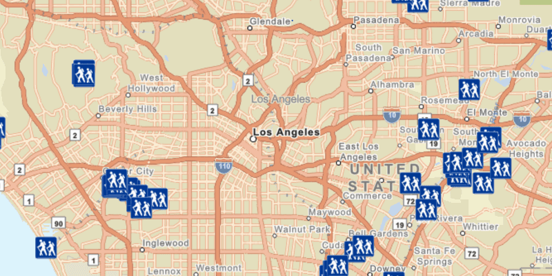
The sample shows trailheads in the greater Los Angeles area displayed on top of a vector tile basemap.
Additional information
Learn more about geodatabases and how to utilize them on the ArcGIS Pro documentation page.
Note: You could also use the 'Services Pattern' and access the Geodatabase class via a Feature Service served up via ArcGIS Online or ArcGIS Enterprise. Instead of using the Geodatabase class to access the .geodatabase file on disk, you would use GeodatabaseSyncTask to point to a Uri instead.
Tags
geodatabase, mobile, offline
Sample Code
/*
* Copyright 2017 Esri.
*
* Licensed under the Apache License, Version 2.0 (the "License"); you may not
* use this file except in compliance with the License. You may obtain a copy of
* the License at
*
* http://www.apache.org/licenses/LICENSE-2.0
*
* Unless required by applicable law or agreed to in writing, software
* distributed under the License is distributed on an "AS IS" BASIS, WITHOUT
* WARRANTIES OR CONDITIONS OF ANY KIND, either express or implied. See the
* License for the specific language governing permissions and limitations under
* the License.
*/
package com.esri.samples.feature_layer_geodatabase;
import java.io.File;
import javafx.application.Application;
import javafx.scene.Scene;
import javafx.scene.control.Alert;
import javafx.scene.layout.StackPane;
import javafx.stage.Stage;
import com.esri.arcgisruntime.ArcGISRuntimeEnvironment;
import com.esri.arcgisruntime.data.Geodatabase;
import com.esri.arcgisruntime.data.GeodatabaseFeatureTable;
import com.esri.arcgisruntime.layers.FeatureLayer;
import com.esri.arcgisruntime.loadable.LoadStatus;
import com.esri.arcgisruntime.mapping.ArcGISMap;
import com.esri.arcgisruntime.mapping.BasemapStyle;
import com.esri.arcgisruntime.mapping.view.MapView;
public class FeatureLayerGeodatabaseSample extends Application {
private MapView mapView;
// keep loadables in scope to avoid garbage collection
private Geodatabase geodatabase;
private FeatureLayer featureLayer;
@Override
public void start(Stage stage) {
try {
// create stack pane and JavaFX app scene
StackPane stackPane = new StackPane();
Scene fxScene = new Scene(stackPane);
// set title, size, and add JavaFX scene to stage
stage.setTitle("Feature Layer Geodatabase Sample");
stage.setWidth(800);
stage.setHeight(700);
stage.setScene(fxScene);
stage.show();
// authentication with an API key or named user is required to access basemaps and other location services
String yourAPIKey = System.getProperty("apiKey");
ArcGISRuntimeEnvironment.setApiKey(yourAPIKey);
// create a map with the streets basemap style
ArcGISMap map = new ArcGISMap(BasemapStyle.ARCGIS_STREETS);
// create a map view and set the map to it
mapView = new MapView();
mapView.setMap(map);
// create geodatabase from local resource
File geodatabaseFile = new File(System.getProperty("data.dir"), "./samples-data/los_angeles/LA_Trails" +
".geodatabase");
geodatabase = new Geodatabase(geodatabaseFile.getAbsolutePath());
geodatabase.addDoneLoadingListener(() -> {
if (geodatabase.getLoadStatus() == LoadStatus.LOADED) {
// access the geodatabase's feature table Trailheads
GeodatabaseFeatureTable geodatabaseFeatureTable = geodatabase.getGeodatabaseFeatureTable("Trailheads");
geodatabaseFeatureTable.loadAsync();
// create a layer from the geodatabase feature table above and add to map
featureLayer = new FeatureLayer(geodatabaseFeatureTable);
featureLayer.addDoneLoadingListener(() -> {
if (featureLayer.getLoadStatus() == LoadStatus.LOADED) {
// set viewpoint to the location of feature layer's features
mapView.setViewpointCenterAsync(featureLayer.getFullExtent().getCenter(), 1000000);
} else {
Alert alert = new Alert(Alert.AlertType.ERROR, "Feature Layer Failed to Load!");
alert.show();
}
});
// display feature layer to the map view
map.getOperationalLayers().add(featureLayer);
} else {
Alert alert = new Alert(Alert.AlertType.ERROR, "Geodatabase Failed to Load!");
alert.show();
}
});
// load geodatabase
geodatabase.loadAsync();
// add the map view to stack pane
stackPane.getChildren().addAll(mapView);
} catch (Exception e) {
// on any error, display the stack trace.
e.printStackTrace();
}
}
/**
* Stops and releases all resources used in application.
*/
@Override
public void stop() {
if (mapView != null) {
mapView.dispose();
}
}
/**
* Opens and runs application.
*
* @param args arguments passed to this application
*/
public static void main(String[] args) {
Application.launch(args);
}
}