Calculate a geodesic path between two points and measure its distance.
Use case
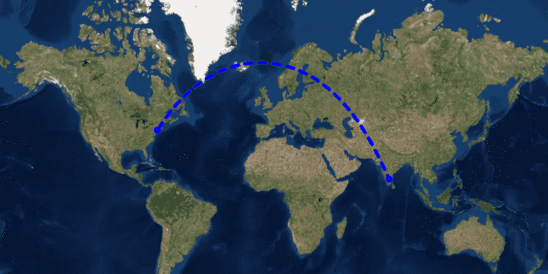
A geodesic distance provides an accurate, real-world distance between two points. Visualizing flight paths between cities is a common example of a geodesic operation since the flight path between two airports takes into account the curvature of the earth, rather than following the planar path between those points, which appears as a straight line on a projected map.
How to use the sample
Click anywhere on the map. A line graphic will display the geodesic line between the two points. In addition, text that indicates the geodesic distance between the two points will be updated. Click elsewhere and a new line will be created.
How it works
- Create a
Pointin and display it as aGraphic. - Obtain a new point when a click occurs on the
MapViewand add this point as a graphic. - Create a
Polylinefrom the two points. - Execute
GeometryEngine.densifyGeodetic()by passing in the created polyine then create a graphic from the returnedGeometry. - Execute
GeometryEngine.lengthGeodetic()by passing in the two points and display the returned length on the screen.
Relevant API
- GeometryEngine
About the data
The Imagery basemap style provides the global context for the displayed geodesic line.
Tags
densify, distance, geodesic, geodetic
Sample Code
/*
* Copyright 2018 Esri.
*
* Licensed under the Apache License, Version 2.0 (the "License"); you may not
* use this file except in compliance with the License. You may obtain a copy of
* the License at
*
* http://www.apache.org/licenses/LICENSE-2.0
*
* Unless required by applicable law or agreed to in writing, software
* distributed under the License is distributed on an "AS IS" BASIS, WITHOUT
* WARRANTIES OR CONDITIONS OF ANY KIND, either express or implied. See the
* License for the specific language governing permissions and limitations under
* the License.
*/
package com.esri.samples.geodesic_operations;
import java.text.DecimalFormat;
import java.util.Arrays;
import javafx.application.Application;
import javafx.geometry.Insets;
import javafx.geometry.Point2D;
import javafx.geometry.Pos;
import javafx.scene.Scene;
import javafx.scene.control.Label;
import javafx.scene.input.MouseButton;
import javafx.scene.layout.Background;
import javafx.scene.layout.BackgroundFill;
import javafx.scene.layout.CornerRadii;
import javafx.scene.layout.StackPane;
import javafx.scene.layout.VBox;
import javafx.scene.paint.Color;
import javafx.scene.paint.Paint;
import javafx.stage.Stage;
import com.esri.arcgisruntime.ArcGISRuntimeEnvironment;
import com.esri.arcgisruntime.geometry.GeodeticCurveType;
import com.esri.arcgisruntime.geometry.Geometry;
import com.esri.arcgisruntime.geometry.GeometryEngine;
import com.esri.arcgisruntime.geometry.LinearUnit;
import com.esri.arcgisruntime.geometry.LinearUnitId;
import com.esri.arcgisruntime.geometry.Point;
import com.esri.arcgisruntime.geometry.PointCollection;
import com.esri.arcgisruntime.geometry.Polyline;
import com.esri.arcgisruntime.geometry.SpatialReference;
import com.esri.arcgisruntime.geometry.SpatialReferences;
import com.esri.arcgisruntime.mapping.ArcGISMap;
import com.esri.arcgisruntime.mapping.BasemapStyle;
import com.esri.arcgisruntime.mapping.view.Graphic;
import com.esri.arcgisruntime.mapping.view.GraphicsOverlay;
import com.esri.arcgisruntime.mapping.view.MapView;
import com.esri.arcgisruntime.symbology.SimpleLineSymbol;
import com.esri.arcgisruntime.symbology.SimpleMarkerSymbol;
public class GeodesicOperationsSample extends Application {
private MapView mapView;
private final SpatialReference srWgs84 = SpatialReferences.getWgs84();
@Override
public void start(Stage stage) {
try {
// create stack pane and application scene
StackPane stackPane = new StackPane();
Scene fxScene = new Scene(stackPane);
fxScene.getStylesheets().add(getClass().getResource("/geodesic_operations/style.css").toExternalForm());
// set title, size, and add scene to stage
stage.setTitle("Geodesic Operations Sample");
stage.setWidth(800);
stage.setHeight(700);
stage.setScene(fxScene);
stage.show();
// authentication with an API key or named user is required to access basemaps and other location services
String yourAPIKey = System.getProperty("apiKey");
ArcGISRuntimeEnvironment.setApiKey(yourAPIKey);
// create a map with the standard imagery basemap style
ArcGISMap map = new ArcGISMap(BasemapStyle.ARCGIS_IMAGERY_STANDARD);
// create a map view and set the map to it
mapView = new MapView();
mapView.setMap(map);
// create a graphics overlay
GraphicsOverlay graphicsOverlay = new GraphicsOverlay();
mapView.getGraphicsOverlays().add(graphicsOverlay);
// add a graphic at JFK airport to represent the flight start location
Point start = new Point(-73.7781, 40.6413, srWgs84);
SimpleMarkerSymbol locationMarker = new SimpleMarkerSymbol(SimpleMarkerSymbol.Style.CIRCLE, Color.BLUE, 10);
Graphic startLocation = new Graphic(start, locationMarker);
graphicsOverlay.getGraphics().add(startLocation);
// create a graphic for the destination
Graphic endLocation = new Graphic();
endLocation.setSymbol(locationMarker);
graphicsOverlay.getGraphics().add(endLocation);
// create a graphic representing the geodesic path between the two locations
Graphic path = new Graphic();
path.setSymbol(new SimpleLineSymbol(SimpleLineSymbol.Style.DASH, Color.BLUE, 5));
graphicsOverlay.getGraphics().add(path);
// create a label to show the distance
Label distanceLabel = new Label();
DecimalFormat formatter = new DecimalFormat("#0.00 km");
distanceLabel.setText(formatter.format(0.0));
VBox labelBox = new VBox(distanceLabel);
labelBox.setBackground(new Background(new BackgroundFill(Paint.valueOf("rgba(0,0,0,0.3)"), CornerRadii.EMPTY,
Insets.EMPTY)));
labelBox.setAlignment(Pos.CENTER);
labelBox.setPadding(new Insets(5));
labelBox.setMaxSize(80, 20);
labelBox.getStyleClass().add("panel-region");
// create a linear unit for measuring the distance
LinearUnit unitOfMeasurement = new LinearUnit(LinearUnitId.KILOMETERS);
// and a mouse click listener to get the user's input for the destination
mapView.setOnMouseClicked(e -> {
if (e.isStillSincePress() && e.getButton() == MouseButton.PRIMARY) {
// change the end location's geometry to the clicked location
Point2D point2D = new Point2D(e.getX(), e.getY());
Point destination = (Point) GeometryEngine.project(mapView.screenToLocation(point2D), srWgs84);
endLocation.setGeometry(destination);
// create a straight line path between the start and end locations
PointCollection points = new PointCollection(Arrays.asList(start, destination), srWgs84);
Polyline polyline = new Polyline(points);
// densify the path as a geodesic curve and show it with the path graphic
Geometry pathGeometry = GeometryEngine.densifyGeodetic(polyline, 1, unitOfMeasurement, GeodeticCurveType
.GEODESIC);
path.setGeometry(pathGeometry);
// calculate the path distance
double distance = GeometryEngine.lengthGeodetic(pathGeometry, unitOfMeasurement, GeodeticCurveType.GEODESIC);
distanceLabel.setText(formatter.format(distance));
}
});
// add the scene view and label box to the stack pane
stackPane.getChildren().addAll(mapView, labelBox);
StackPane.setMargin(labelBox, new Insets(10, 0, 0, 10));
StackPane.setAlignment(labelBox, Pos.TOP_LEFT);
} catch (Exception e) {
// on any error, display the stack trace.
e.printStackTrace();
}
}
/**
* Stops and releases all resources used in application.
*/
@Override
public void stop() {
if (mapView != null) {
mapView.dispose();
}
}
/**
* Opens and runs application.
*
* @param args arguments passed to this application
*/
public static void main(String[] args) {
Application.launch(args);
}
}