Analyze the viewshed for an object (GeoElement) in a scene.
Use case
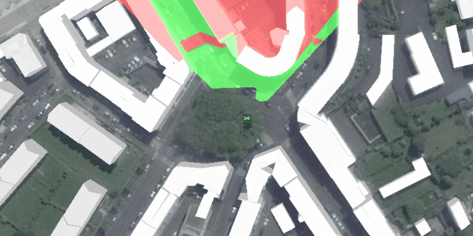
A viewshed analysis is a type of visual analysis you can perform on a scene. The viewshed aims to answer the question 'What can I see from a given location?'. The output is an overlay with two different colors - one representing the visible areas (green) and the other representing the obstructed areas (red).
How to use the sample
Click to set a destination for the vehicle (a GeoElement). The vehicle will 'drive' towards the clicked location. The viewshed analysis will update as the vehicle moves.
How it works
- Create and show the scene, with an elevation source and a buildings layer.
- Add a model (the
GeoElement) to represent the observer (in this case, a tank).- Use a
SimpleRendererwhich has a heading expression set in theGraphicsOverlay. This way you can relate the viewshed's heading to theGeoElementobject's heading.
- Use a
- Create a
GeoElementViewshedwith configuration for the viewshed analysis. - Add the viewshed to an
AnalysisOverlayand add the overlay to the scene. - Configure the SceneView
OrbitGeoElementCameraControllerto orbit the vehicle.
About the data
This sample shows a Johannesburg, South Africa Scene from ArcGIS Online. The sample uses a Tank model scene symbol hosted as an item on ArcGIS Online.
Relevant API
- AnalysisOverlay
- GeodeticDistanceResult
- GeoElementViewshed
- GeometryEngine.distanceGeodetic (used to animate the vehicle)
- ModelSceneSymbol
- OrbitGeoElementCameraController
Tags
3D, analysis, buildings, model, scene, viewshed, visibility analysis
Sample Code
/*
* Copyright 2017 Esri.
*
* Licensed under the Apache License, Version 2.0 (the "License"); you may not
* use this file except in compliance with the License. You may obtain a copy of
* the License at
*
* http://www.apache.org/licenses/LICENSE-2.0
*
* Unless required by applicable law or agreed to in writing, software
* distributed under the License is distributed on an "AS IS" BASIS, WITHOUT
* WARRANTIES OR CONDITIONS OF ANY KIND, either express or implied. See the
* License for the specific language governing permissions and limitations under
* the License.
*/
package com.esri.samples.viewshed_geoelement;
import java.io.File;
import javafx.animation.KeyFrame;
import javafx.animation.Timeline;
import javafx.application.Application;
import javafx.geometry.Point2D;
import javafx.scene.Scene;
import javafx.scene.input.MouseButton;
import javafx.scene.layout.StackPane;
import javafx.stage.Stage;
import javafx.util.Duration;
import com.esri.arcgisruntime.ArcGISRuntimeEnvironment;
import com.esri.arcgisruntime.geoanalysis.GeoElementViewshed;
import com.esri.arcgisruntime.geometry.AngularUnit;
import com.esri.arcgisruntime.geometry.AngularUnitId;
import com.esri.arcgisruntime.geometry.GeodeticCurveType;
import com.esri.arcgisruntime.geometry.GeodeticDistanceResult;
import com.esri.arcgisruntime.geometry.GeometryEngine;
import com.esri.arcgisruntime.geometry.LinearUnit;
import com.esri.arcgisruntime.geometry.LinearUnitId;
import com.esri.arcgisruntime.geometry.Point;
import com.esri.arcgisruntime.geometry.SpatialReferences;
import com.esri.arcgisruntime.layers.ArcGISSceneLayer;
import com.esri.arcgisruntime.mapping.ArcGISScene;
import com.esri.arcgisruntime.mapping.ArcGISTiledElevationSource;
import com.esri.arcgisruntime.mapping.BasemapStyle;
import com.esri.arcgisruntime.mapping.Surface;
import com.esri.arcgisruntime.mapping.view.AnalysisOverlay;
import com.esri.arcgisruntime.mapping.view.Graphic;
import com.esri.arcgisruntime.mapping.view.GraphicsOverlay;
import com.esri.arcgisruntime.mapping.view.LayerSceneProperties;
import com.esri.arcgisruntime.mapping.view.OrbitGeoElementCameraController;
import com.esri.arcgisruntime.mapping.view.SceneView;
import com.esri.arcgisruntime.symbology.ModelSceneSymbol;
import com.esri.arcgisruntime.symbology.Renderer;
import com.esri.arcgisruntime.symbology.SceneSymbol;
import com.esri.arcgisruntime.symbology.SimpleRenderer;
public class ViewshedGeoElementSample extends Application {
private SceneView sceneView;
private Graphic tank;
private Timeline animation;
private Point waypoint;
private static final LinearUnit METERS = new LinearUnit(LinearUnitId.METERS);
private static final AngularUnit DEGREES = new AngularUnit(AngularUnitId.DEGREES);
@Override
public void start(Stage stage) {
try {
// create stack pane and JavaFX app scene
StackPane stackPane = new StackPane();
Scene fxScene = new Scene(stackPane);
// set title, size, and add JavaFX scene to stage
stage.setTitle("Viewshed GeoElement Sample");
stage.setWidth(800);
stage.setHeight(700);
stage.setScene(fxScene);
stage.show();
// authentication with an API key or named user is required to access basemaps and other location services
String yourAPIKey = System.getProperty("apiKey");
ArcGISRuntimeEnvironment.setApiKey(yourAPIKey);
// create a scene with a basemap style
ArcGISScene scene = new ArcGISScene(BasemapStyle.ARCGIS_IMAGERY);
// add the SceneView to the stack pane
sceneView = new SceneView();
sceneView.setArcGISScene(scene);
stackPane.getChildren().addAll(sceneView);
// add base surface for elevation data
Surface surface = new Surface();
final String elevationImageService = "https://elevation3d.arcgis.com" +
"/arcgis/rest/services/WorldElevation3D/Terrain3D/ImageServer";
surface.getElevationSources().add(new ArcGISTiledElevationSource(elevationImageService));
scene.setBaseSurface(surface);
// add a scene layer
final String buildings = "https://tiles.arcgis.com/tiles/P3ePLMYs2RVChkJx/arcgis/rest/services/Buildings_Brest/SceneServer/layers/0";
ArcGISSceneLayer sceneLayer = new ArcGISSceneLayer(buildings);
scene.getOperationalLayers().add(sceneLayer);
// create a graphics overlay for the tank
GraphicsOverlay graphicsOverlay = new GraphicsOverlay();
graphicsOverlay.getSceneProperties().setSurfacePlacement(LayerSceneProperties.SurfacePlacement.RELATIVE);
sceneView.getGraphicsOverlays().add(graphicsOverlay);
// set up heading expression for tank
SimpleRenderer renderer3D = new SimpleRenderer();
Renderer.SceneProperties renderProperties = renderer3D.getSceneProperties();
renderProperties.setHeadingExpression("[HEADING]");
graphicsOverlay.setRenderer(renderer3D);
// create a graphic of a tank
String modelURI = new File(System.getProperty("data.dir"), "./samples-data/bradley_low_3ds/bradle.3ds").getAbsolutePath();
ModelSceneSymbol tankSymbol = new ModelSceneSymbol(modelURI.replace("\\", "/"), 10.0);
tankSymbol.setHeading(90);
tankSymbol.setAnchorPosition(SceneSymbol.AnchorPosition.BOTTOM);
tankSymbol.loadAsync();
tank = new Graphic(new Point(-4.506390, 48.385624, SpatialReferences.getWgs84()), tankSymbol);
tank.getAttributes().put("HEADING", 0.0);
graphicsOverlay.getGraphics().add(tank);
// create a viewshed to attach to the tank
GeoElementViewshed geoElementViewshed = new GeoElementViewshed(tank, 90.0, 40.0, 0.1, 250.0, 0.0, 0.0);
// offset viewshed observer location to top of tank
geoElementViewshed.setOffsetZ(3.0);
// create an analysis overlay to add the viewshed to the scene view
AnalysisOverlay analysisOverlay = new AnalysisOverlay();
analysisOverlay.getAnalyses().add(geoElementViewshed);
sceneView.getAnalysisOverlays().add(analysisOverlay);
// set the waypoint where the user clicks
sceneView.setOnMouseClicked(e -> {
if (e.isStillSincePress() && e.getButton() == MouseButton.PRIMARY) {
// create a point from where the user clicked
Point2D point = new Point2D(e.getX(), e.getY());
// set the new waypoint
waypoint = sceneView.screenToBaseSurface(point);
}
});
// set camera controller to follow tank
OrbitGeoElementCameraController cameraController = new OrbitGeoElementCameraController(tank, 200.0);
cameraController.setCameraPitchOffset(45.0);
sceneView.setCameraController(cameraController);
// create a timeline to animate the tank
animation = new Timeline();
animation.setCycleCount(-1);
animation.getKeyFrames().add(new KeyFrame(Duration.millis(100), e -> animate()));
animation.play();
} catch (Exception e) {
// on any error, display the stack trace.
e.printStackTrace();
}
}
/**
* Moves the tank toward the current waypoint a short distance.
*/
private void animate() {
if (waypoint != null) {
// get current location and distance from waypoint
Point location = (Point) tank.getGeometry();
GeodeticDistanceResult distance = GeometryEngine.distanceGeodetic(location, waypoint, METERS, DEGREES,
GeodeticCurveType.GEODESIC);
// move toward waypoint a short distance
location = GeometryEngine.moveGeodetic(location, 1.0, METERS, distance.getAzimuth1(), DEGREES,
GeodeticCurveType.GEODESIC);
tank.setGeometry(location);
// rotate toward waypoint
double heading = (double) tank.getAttributes().get("HEADING");
tank.getAttributes().put("HEADING", heading + ((distance.getAzimuth1() - heading) / 10));
// reached waypoint, stop moving
if (distance.getDistance() <= 5) {
waypoint = null;
}
}
}
/**
* Stops and releases all resources used in application.
*/
@Override
public void stop() {
// stop the animation
animation.stop();
if (sceneView != null) {
sceneView.dispose();
}
}
/**
* Opens and runs application.
*
* @param args arguments passed to this application
*/
public static void main(String[] args) {
Application.launch(args);
}
}