Measure distances between two points in 3D.
Use case
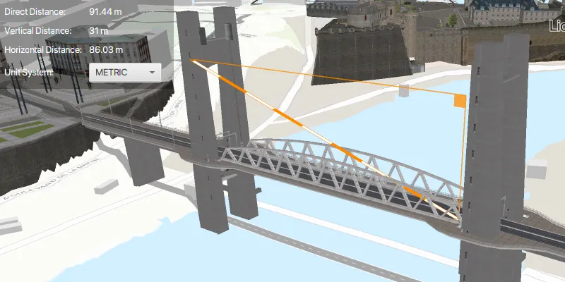
The distance measurement analysis allows you to add to your app the same interactive measuring experience found in ArcGIS Pro, City Engine, and the ArcGIS API for JavaScript. You can set the unit system of measurement (metric or imperial). The units automatically switch to one appropriate for the current scale.
How to use the sample
Choose a unit system for the measurement. Click any location in the scene to start measuring. Move the mouse to an end location, and click to complete the measurement. Click a new location to clear and start a new measurement.
How it works
- Create an
AnalysisOverlayobject and add it to the analysis overlay collection of theSceneViewobject. - Specify the start location and end location to create a
LocationDistanceMeasurementobject. Initially, the start and end locations can be the same point. - Add the location distance measurement analysis to the analysis overlay.
- The
measurementChangedcallback will trigger if the distances change. You can get the new values for thedirectDistance,horizontalDistance, andverticalDistancefrom theMeasurementChangedEventobject returned by the callback.
Relevant API
- AnalysisOverlay
- LocationDistanceMeasurement
Additional information
The LocationDistanceMeasurement analysis only performs planar distance calculations. This may not be appropriate for large distances where the Earth’s curvature must be considered.
Tags
3D, analysis, distance, measure
Sample code
/* * Copyright 2018 Esri. * * Licensed under the Apache License, Version 2.0 (the "License"); you may not * use this file except in compliance with the License. You may obtain a copy of * the License at * * http://www.apache.org/licenses/LICENSE-2.0 * * Unless required by applicable law or agreed to in writing, software * distributed under the License is distributed on an "AS IS" BASIS, WITHOUT * WARRANTIES OR CONDITIONS OF ANY KIND, either express or implied. See the * License for the specific language governing permissions and limitations under * the License. */
package com.esri.samples.distance_measurement_analysis;
import java.text.DecimalFormat;import java.util.concurrent.ExecutionException;
import javafx.event.EventHandler;import javafx.fxml.FXML;import javafx.geometry.Point2D;import javafx.scene.control.Alert;import javafx.scene.control.ComboBox;import javafx.scene.control.Label;import javafx.scene.input.MouseButton;import javafx.scene.input.MouseEvent;
import com.esri.arcgisruntime.ArcGISRuntimeEnvironment;import com.esri.arcgisruntime.UnitSystem;import com.esri.arcgisruntime.concurrent.ListenableFuture;import com.esri.arcgisruntime.geoanalysis.LocationDistanceMeasurement;import com.esri.arcgisruntime.geometry.Distance;import com.esri.arcgisruntime.geometry.Point;import com.esri.arcgisruntime.geometry.SpatialReferences;import com.esri.arcgisruntime.layers.ArcGISSceneLayer;import com.esri.arcgisruntime.loadable.LoadStatus;import com.esri.arcgisruntime.mapping.ArcGISScene;import com.esri.arcgisruntime.mapping.ArcGISTiledElevationSource;import com.esri.arcgisruntime.mapping.BasemapStyle;import com.esri.arcgisruntime.mapping.Surface;import com.esri.arcgisruntime.mapping.view.AnalysisOverlay;import com.esri.arcgisruntime.mapping.view.Camera;import com.esri.arcgisruntime.mapping.view.SceneView;
public class DistanceMeasurementAnalysisController {
  @FXML private SceneView sceneView;  @FXML private Label directDistanceLabel;  @FXML private Label verticalDistanceLabel;  @FXML private Label horizontalDistanceLabel;  @FXML private ComboBox<UnitSystem> unitSystemComboBox;
  private LocationDistanceMeasurement distanceMeasurement;
  public void initialize() {
    // authentication with an API key or named user is required to access basemaps and other location services    String yourAPIKey = System.getProperty("apiKey");    ArcGISRuntimeEnvironment.setApiKey(yourAPIKey);
    // create a scene with a basemap style and set it to the scene view    ArcGISScene scene = new ArcGISScene(BasemapStyle.ARCGIS_TOPOGRAPHIC);    sceneView.setArcGISScene(scene);
    // add base surface for elevation data    Surface surface = new Surface();    surface.getElevationSources().add(new ArcGISTiledElevationSource(      "https://elevation3d.arcgis.com/arcgis/rest/services/WorldElevation3D/Terrain3D/ImageServer"));    scene.setBaseSurface(surface);
    final String buildings = "http://tiles.arcgis.com/tiles/P3ePLMYs2RVChkJx/arcgis/rest/services/Buildings_Brest/SceneServer/layers/0";    ArcGISSceneLayer sceneLayer = new ArcGISSceneLayer(buildings);    sceneLayer.setAltitudeOffset(1); // offset for visual purposes    scene.getOperationalLayers().add(sceneLayer);
    // create an analysis overlay and add it to the scene view    AnalysisOverlay analysisOverlay = new AnalysisOverlay();    sceneView.getAnalysisOverlays().add(analysisOverlay);
    // initialize a distance measurement and add it to the analysis overlay    Point start = new Point(-4.494677, 48.384472, 24.772694, SpatialReferences.getWgs84());    Point end = new Point(-4.495646, 48.384377, 58.501115, SpatialReferences.getWgs84());    distanceMeasurement = new LocationDistanceMeasurement(start, end);    analysisOverlay.getAnalyses().add(distanceMeasurement);
    // zoom to the initial measurement    scene.addDoneLoadingListener(() -> {      if (scene.getLoadStatus() == LoadStatus.LOADED) {        sceneView.setViewpointCamera(new Camera(start, 200.0, 0.0, 45.0, 0.0));      } else {        new Alert(Alert.AlertType.ERROR, "Scene failed to load").show();      }    });
    // show the distances in the UI when the measurement changes    DecimalFormat decimalFormat = new DecimalFormat("#.##");    distanceMeasurement.addMeasurementChangedListener(e -> {      Distance directDistance = e.getDirectDistance();      Distance verticalDistance = e.getVerticalDistance();      Distance horizontalDistance = e.getHorizontalDistance();      directDistanceLabel.setText(decimalFormat.format(directDistance.getValue()) + " " + directDistance.getUnit()          .getAbbreviation());      verticalDistanceLabel.setText(decimalFormat.format(verticalDistance.getValue()) + " " + verticalDistance          .getUnit().getAbbreviation());      horizontalDistanceLabel.setText(decimalFormat.format(horizontalDistance.getValue()) + " " + horizontalDistance          .getUnit().getAbbreviation());    });
    // add the unit system options to the UI initialized with the measurement's default value (METRIC)    unitSystemComboBox.getItems().addAll(UnitSystem.values());    unitSystemComboBox.setValue(distanceMeasurement.getUnitSystem());
    // remove the default mouse move handler    sceneView.setOnMouseMoved(null);
    // create a handler to update the measurement's end location when the mouse moves    EventHandler<MouseEvent> mouseMoveEventHandler = event -> {      Point2D point2D = new Point2D(event.getX(), event.getY());      // get the scene location from the screen position      ListenableFuture<Point> pointFuture = sceneView.screenToLocationAsync(point2D);      pointFuture.addDoneListener(() -> {        try {          // update the end location          Point point = pointFuture.get();          distanceMeasurement.setEndLocation(point);        } catch (InterruptedException | ExecutionException e) {          e.printStackTrace();        }      });    };
    // mouse click to start/stop moving a measurement    sceneView.setOnMouseClicked(event -> {      if (event.isStillSincePress() && event.getButton() == MouseButton.PRIMARY) {        // get the clicked location        Point2D point2D = new Point2D(event.getX(), event.getY());        ListenableFuture<Point> pointFuture = sceneView.screenToLocationAsync(point2D);        pointFuture.addDoneListener(() -> {          try {            Point point = pointFuture.get();            if (sceneView.getOnMouseMoved() == null) {              // reset the measurement at the clicked location and start listening for mouse movement              sceneView.setOnMouseMoved(mouseMoveEventHandler);              distanceMeasurement.setStartLocation(point);              distanceMeasurement.setEndLocation(point);            } else {              // set the measurement end location and stop listening for mouse movement              sceneView.setOnMouseMoved(null);              distanceMeasurement.setEndLocation(point);            }          } catch (InterruptedException | ExecutionException e) {            e.printStackTrace();          }        });      }    });  }
  /**   * Update the measurement's unit system when the combo box option is changed.   */  @FXML  private void changeUnitSystem() {
    distanceMeasurement.setUnitSystem(unitSystemComboBox.getValue());  }
  /**   * Stops and releases all resources used in application.   */  void terminate() {
    if (sceneView != null) {      sceneView.dispose();    }  }
}
/* * Copyright 2018 Esri. * * Licensed under the Apache License, Version 2.0 (the "License"); you may not * use this file except in compliance with the License. You may obtain a copy of * the License at * * http://www.apache.org/licenses/LICENSE-2.0 * * Unless required by applicable law or agreed to in writing, software * distributed under the License is distributed on an "AS IS" BASIS, WITHOUT * WARRANTIES OR CONDITIONS OF ANY KIND, either express or implied. See the * License for the specific language governing permissions and limitations under * the License. */
package com.esri.samples.distance_measurement_analysis;
import java.io.IOException;
import javafx.application.Application;import javafx.fxml.FXMLLoader;import javafx.scene.Parent;import javafx.scene.Scene;import javafx.stage.Stage;
public class DistanceMeasurementAnalysisSample extends Application {
private static DistanceMeasurementAnalysisController controller;
@Override public void start(Stage stage) throws IOException { // set up the scene FXMLLoader loader = new FXMLLoader(getClass().getResource("/distance_measurement_analysis/main.fxml")); Parent root = loader.load(); controller = loader.getController(); Scene scene = new Scene(root);
// set up the stage stage.setTitle("Distance Measurement Analysis Sample"); stage.setWidth(800); stage.setHeight(700); stage.setScene(scene); stage.show(); }
/** * Stops and releases all resources used in application. */ @Override public void stop() { controller.terminate(); }
/** * Opens and runs application. * * @param args arguments passed to this application */ public static void main(String[] args) {
Application.launch(args); }}