Show a callout with formatted content for a KML feature.
Use case
A user may wish to select a KML feature to view relevant information about it.
How to use the sample
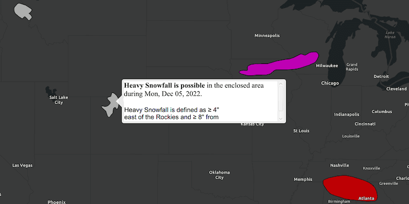
Click on a feature to identify it. Feature information will be displayed in a callout.
Note: the KML layer used in this sample contains a screen overlay. The screen overlay contains a legend and the logos for NOAA and the NWS. You can't identify the screen overlay.
How it works
- Listen to clicks on the
MapViewusingsetOnMouseClicked(). - When the map view is clicked:
- Dismiss the
Callout, if one is showing. - Call
identifyLayerAsync(...)passing in theKmlLayer, screen point and tolerance. - Await the result of the identify and then get the
KmlPlacemarkfrom the result. - Create a callout at the calculated map point and populate the callout content with text from the placemark's "balloon content". NOTE: KML supports defining HTML for balloon content and may need to be converted from HTML to text.
- Show the callout.
Note: There are several types of KML features. This sample only identifies features of type KmlPlacemark.
Relevant API
- IdentifyLayerResult
- KmlLayer
- KmlPlacemark
- MapView
About the data
This sample shows a forecast for significant weather within the U.S. Regions of severe thunderstorms, flooding, snowfall, and freezing rain are shown.
Additional information
KML features can have rich HTML content, including images.
Tags
Keyhole, KML, KMZ, NOAA, NWS, OGC, weather
Sample Code
/*
* Copyright 2018 Esri.
*
* Licensed under the Apache License, Version 2.0 (the "License"); you may not
* use this file except in compliance with the License. You may obtain a copy of
* the License at
*
* http://www.apache.org/licenses/LICENSE-2.0
*
* Unless required by applicable law or agreed to in writing, software
* distributed under the License is distributed on an "AS IS" BASIS, WITHOUT
* WARRANTIES OR CONDITIONS OF ANY KIND, either express or implied. See the
* License for the specific language governing permissions and limitations under
* the License.
*/
package com.esri.samples.identify_kml_features;
import java.util.concurrent.ExecutionException;
import com.esri.arcgisruntime.ArcGISRuntimeEnvironment;
import com.esri.arcgisruntime.concurrent.ListenableFuture;
import com.esri.arcgisruntime.geometry.Envelope;
import com.esri.arcgisruntime.geometry.Point;
import com.esri.arcgisruntime.geometry.SpatialReferences;
import com.esri.arcgisruntime.layers.KmlLayer;
import com.esri.arcgisruntime.mapping.ArcGISMap;
import com.esri.arcgisruntime.mapping.BasemapStyle;
import com.esri.arcgisruntime.mapping.GeoElement;
import com.esri.arcgisruntime.mapping.view.IdentifyLayerResult;
import com.esri.arcgisruntime.mapping.view.MapView;
import com.esri.arcgisruntime.ogc.kml.KmlDataset;
import com.esri.arcgisruntime.ogc.kml.KmlPlacemark;
import javafx.application.Application;
import javafx.geometry.Point2D;
import javafx.scene.Scene;
import javafx.scene.control.Alert;
import javafx.scene.input.MouseButton;
import javafx.scene.layout.StackPane;
import javafx.scene.layout.VBox;
import javafx.scene.web.WebView;
import javafx.stage.Stage;
public class IdentifyKMLFeaturesSample extends Application {
private MapView mapView;
@Override
public void start(Stage stage) {
try {
// create stack pane and application scene
StackPane stackPane = new StackPane();
Scene scene = new Scene(stackPane);
// set title, size, and add scene to stage
stage.setTitle("Identify KML Features Sample");
stage.setWidth(800);
stage.setHeight(700);
stage.setScene(scene);
stage.show();
// authentication with an API key or named user is required to access basemaps and other location services
String yourAPIKey = System.getProperty("apiKey");
ArcGISRuntimeEnvironment.setApiKey(yourAPIKey);
// create a map with the dark gray basemap style
ArcGISMap map = new ArcGISMap(BasemapStyle.ARCGIS_DARK_GRAY);
// create a map view and set the map to it
mapView = new MapView();
mapView.setMap(map);
// start zoomed in over the US
mapView.setViewpointGeometryAsync(new Envelope(-19195297.778679, 512343.939994, -3620418.579987, 8658913.035426, 0.0, 0.0, SpatialReferences.getWebMercator()));
// create a KML dataset of weather forecasts
KmlDataset forecastDataset = new KmlDataset("https://www.wpc.ncep.noaa.gov/kml/noaa_chart/WPC_Day1_SigWx_latest.kml");
// create a KML layer and add it as an operational layer
KmlLayer forecastLayer = new KmlLayer(forecastDataset);
map.getOperationalLayers().add(forecastLayer);
// add a click listener to identify clicked features
mapView.setOnMouseClicked(e -> {
// hide the callout if it's showing
mapView.getCallout().dismiss();
if (e.isStillSincePress() && e.getButton() == MouseButton.PRIMARY) {
// get the identified geoelements at the clicked location
Point2D screenPoint = new Point2D(e.getX(), e.getY());
ListenableFuture<IdentifyLayerResult> identify = mapView.identifyLayerAsync(forecastLayer, screenPoint, 15, false);
identify.addDoneListener(() -> {
try {
IdentifyLayerResult result = identify.get();
// find the first geoElement that is a KML placemark
for (GeoElement geoElement : result.getElements()) {
if (geoElement instanceof KmlPlacemark) {
// show a callout at the placemark with custom content using the placemark's "balloon content"
KmlPlacemark placemark = (KmlPlacemark) geoElement;
// Google Earth only displays the placemarks with description or extended data. To
// match its behavior, add a description placeholder if the data source is empty
if (placemark.getDescription().isEmpty()) {
placemark.setDescription("Weather condition");
}
VBox vBox = new VBox();
WebView webView = new WebView();
webView.setMaxSize(400, 100);
vBox.setMaxSize(430, 100);
webView.getEngine().loadContent(placemark.getBalloonContent());
vBox.getChildren().add(webView);
mapView.getCallout().setCustomView(vBox);
mapView.getCallout().setMaxSize(430, 100);
Point interactionPoint = mapView.screenToLocation(screenPoint);
mapView.getCallout().showCalloutAt(geoElement, interactionPoint);
break;
}
}
} catch (InterruptedException | ExecutionException ex) {
new Alert(Alert.AlertType.ERROR, "Error identifying features in layer").show();
}
});
}
});
// add the map view to stack pane
stackPane.getChildren().add(mapView);
} catch (Exception e) {
// on any error, display the stack trace.
e.printStackTrace();
}
}
/**
* Stops and releases all resources used in application.
*/
@Override
public void stop() {
if (mapView != null) {
mapView.dispose();
}
}
/**
* Opens and runs application.
*
* @param args arguments passed to this application
*/
public static void main(String[] args) {
Application.launch(args);
}
}