Find the closest vertex and coordinate of a geometry to a point.
Use case
Determine the shortest distance between a location and the boundary of an area. For example, developers can snap imprecise user clicks to a geometry if the click is within a certain distance of the geometry.
How to use the sample
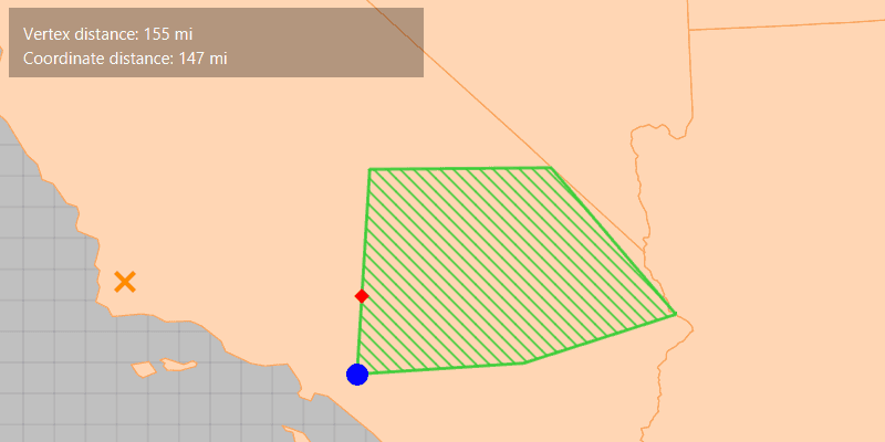
Click anywhere on the map. An orange cross will show at that location. A blue circle will show the polygon's nearest vertex to the point that was clicked. A red diamond will appear at the coordinate on the geometry that is nearest to the point that was clicked. If clicked inside the geometry, the red and orange markers will overlap. The information box showing distance between the clicked point and the nearest vertex/coordinate will be updated with every new location clicked.
How it works
- Get a
Geometryand aPointto check the nearest vertex against. - Call
GeometryEngine.nearestVertex(inputGeometry, point). - Use the returned
ProximityResultto get thePointrepresenting the polygon vertex, and to determine the distance between that vertex and the clicked point. - Call
GeometryEngine.nearestCoordinate(inputGeometry, point). - Use the returned
ProximityResultto get thePointrepresenting the coordinate on the polygon, and to determine the distance between that coordinate and the clicked point.
Relevant API
- GeometryEngine
- ProximityResult
Additional information
The value of ProximityResult.getDistance() is planar (Euclidean) distance. Planar distances are only accurate for geometries that have a defined projected coordinate system, which maintain the desired level of accuracy. The example polygon in this sample is defined in California State Plane Coordinate System - Zone 5 (WKID 2229), which maintains accuracy near Southern California. Accuracy declines outside the state plane zone.
Tags
analysis, coordinate, geometry, nearest, proximity, vertex
Sample Code
/*
* Copyright 2018 Esri.
*
* Licensed under the Apache License, Version 2.0 (the "License"); you may not
* use this file except in compliance with the License. You may obtain a copy of
* the License at
*
* http://www.apache.org/licenses/LICENSE-2.0
*
* Unless required by applicable law or agreed to in writing, software
* distributed under the License is distributed on an "AS IS" BASIS, WITHOUT
* WARRANTIES OR CONDITIONS OF ANY KIND, either express or implied. See the
* License for the specific language governing permissions and limitations under
* the License.
*/
package com.esri.samples.nearest_vertex;
import java.util.Arrays;
import javafx.application.Application;
import javafx.beans.binding.Bindings;
import javafx.geometry.Insets;
import javafx.geometry.Point2D;
import javafx.geometry.Pos;
import javafx.scene.Scene;
import javafx.scene.control.Label;
import javafx.scene.input.MouseButton;
import javafx.scene.layout.Background;
import javafx.scene.layout.BackgroundFill;
import javafx.scene.layout.CornerRadii;
import javafx.scene.layout.StackPane;
import javafx.scene.layout.VBox;
import javafx.scene.paint.Color;
import javafx.scene.paint.Paint;
import javafx.stage.Stage;
import com.esri.arcgisruntime.ArcGISRuntimeEnvironment;
import com.esri.arcgisruntime.geometry.SpatialReference;
import com.esri.arcgisruntime.geometry.GeometryEngine;
import com.esri.arcgisruntime.geometry.Point;
import com.esri.arcgisruntime.geometry.PointCollection;
import com.esri.arcgisruntime.geometry.Polygon;
import com.esri.arcgisruntime.geometry.ProximityResult;
import com.esri.arcgisruntime.layers.FeatureLayer;
import com.esri.arcgisruntime.mapping.ArcGISMap;
import com.esri.arcgisruntime.mapping.view.Graphic;
import com.esri.arcgisruntime.mapping.view.GraphicsOverlay;
import com.esri.arcgisruntime.mapping.view.MapView;
import com.esri.arcgisruntime.portal.Portal;
import com.esri.arcgisruntime.portal.PortalItem;
import com.esri.arcgisruntime.symbology.SimpleFillSymbol;
import com.esri.arcgisruntime.symbology.SimpleLineSymbol;
import com.esri.arcgisruntime.symbology.SimpleMarkerSymbol;
public class NearestVertexSample extends Application {
private MapView mapView;
// California zone 5 (ftUS) state plane coordinate system
private final SpatialReference statePlaneCaliforniaZone5SpatialReference = SpatialReference.create(2229);
@Override
public void start(Stage stage) {
try {
// create stack pane and application scene
StackPane stackPane = new StackPane();
Scene scene = new Scene(stackPane);
scene.getStylesheets().add(getClass().getResource("/nearest_vertex/style.css").toExternalForm());
// set title, size, and add scene to stage
stage.setTitle("Nearest Vertex Sample");
stage.setWidth(800);
stage.setHeight(700);
stage.setScene(scene);
stage.show();
// authentication with an API key or named user is required to access basemaps and other location services
String yourAPIKey = System.getProperty("apiKey");
ArcGISRuntimeEnvironment.setApiKey(yourAPIKey);
// create a new feature layer from a new portal item
var portalItem = new PortalItem(
new Portal("https://arcgisruntime.maps.arcgis.com", false), "99fd67933e754a1181cc755146be21ca");
FeatureLayer usStatesGeneralizedLayer = new FeatureLayer(portalItem, 0);
// create a new map using the California zone 5 spatial reference
ArcGISMap map = new ArcGISMap(statePlaneCaliforniaZone5SpatialReference);
// add the feature layer to the map's list of base layers
map.getBasemap().getBaseLayers().add(usStatesGeneralizedLayer);
// create a map view and set the map to it
mapView = new MapView();
mapView.setMap(map);
// create a graphics overlay to show the polygon, clicked location, and nearest vertex/coordinate
GraphicsOverlay graphicsOverlay = new GraphicsOverlay();
mapView.getGraphicsOverlays().add(graphicsOverlay);
// construct a polygon from a point collection that uses the California zone 5 (ftUS) state plane coordinate system
PointCollection polygonPoints = new PointCollection(statePlaneCaliforniaZone5SpatialReference);
polygonPoints.addAll(Arrays.asList(
new Point(6627416.41469281, 1804532.53233782),
new Point(6669147.89779046, 2479145.16609522),
new Point(7265673.02678292, 2484254.50442408),
new Point(7676192.55880379, 2001458.66365744),
new Point(7175695.94143837, 1840722.34474458)));
// create a graphic for the polygon
Polygon polygon = new Polygon(polygonPoints);
SimpleLineSymbol polygonOutlineSymbol = new SimpleLineSymbol(SimpleLineSymbol.Style.SOLID, Color.LIMEGREEN, 2);
SimpleFillSymbol polygonFillSymbol = new SimpleFillSymbol(SimpleFillSymbol.Style.FORWARD_DIAGONAL, Color.LIMEGREEN, polygonOutlineSymbol);
Graphic polygonGraphic = new Graphic(polygon, polygonFillSymbol);
graphicsOverlay.getGraphics().add(polygonGraphic);
// create graphics for the clicked location, nearest coordinate, and nearest vertex markers
SimpleMarkerSymbol clickedLocationSymbol = new SimpleMarkerSymbol(SimpleMarkerSymbol.Style.X, Color.DARKORANGE, 15);
SimpleMarkerSymbol nearestCoordinateSymbol = new SimpleMarkerSymbol(SimpleMarkerSymbol.Style.DIAMOND, Color.RED, 10);
SimpleMarkerSymbol nearestVertexSymbol = new SimpleMarkerSymbol(SimpleMarkerSymbol.Style.CIRCLE, Color.BLUE, 15);
Graphic clickedLocationGraphic = new Graphic();
clickedLocationGraphic.setSymbol(clickedLocationSymbol);
Graphic nearestCoordinateGraphic = new Graphic();
nearestCoordinateGraphic.setSymbol(nearestCoordinateSymbol);
Graphic nearestVertexGraphic = new Graphic();
nearestVertexGraphic.setSymbol(nearestVertexSymbol);
graphicsOverlay.getGraphics().addAll(Arrays.asList(clickedLocationGraphic, nearestCoordinateGraphic, nearestVertexGraphic));
// create a label to show the distances between the nearest vertex and nearest coordinate to the clicked location
Label distancesLabel = new Label("");
distancesLabel.getStyleClass().add("panel-label");
// create a black background for the label
VBox controlsVBox = new VBox(6);
controlsVBox.setBackground(new Background(new BackgroundFill(Paint.valueOf("rgba(0,0,0,0.3)"), CornerRadii.EMPTY,
Insets.EMPTY)));
controlsVBox.setPadding(new Insets(10.0));
controlsVBox.setMaxSize(300, 50);
controlsVBox.getStyleClass().add("panel-region");
controlsVBox.getChildren().add(distancesLabel);
// hide it until the label text is set
controlsVBox.visibleProperty().bind(Bindings.createBooleanBinding(() -> !distancesLabel.getText().equals(""), distancesLabel.textProperty()));
controlsVBox.managedProperty().bind(controlsVBox.visibleProperty());
// get the nearest vertex and coordinate where the user clicks
mapView.setOnMouseClicked(e -> {
if (e.isStillSincePress() && e.getButton() == MouseButton.PRIMARY) {
// create a point from where the user clicked
Point2D point = new Point2D(e.getX(), e.getY());
// create a map point from a point
Point mapPoint = mapView.screenToLocation(point);
// show where the user clicked
clickedLocationGraphic.setGeometry(mapPoint);
// show the nearest coordinate and vertex
ProximityResult nearestCoordinateResult = GeometryEngine.nearestCoordinate(polygon, mapPoint);
ProximityResult nearestVertexResult = GeometryEngine.nearestVertex(polygon, mapPoint);
nearestVertexGraphic.setGeometry(nearestVertexResult.getCoordinate());
nearestCoordinateGraphic.setGeometry(nearestCoordinateResult.getCoordinate());
// show the distances to the nearest vertex and nearest coordinate, converted from feet to miles
int vertexDistance = (int) (nearestVertexResult.getDistance() / 5280.0);
int coordinateDistance = (int) (nearestCoordinateResult.getDistance() / 5280.0);
distancesLabel.setText("Vertex distance: " + vertexDistance + " mi\nCoordinate distance: " + coordinateDistance + " mi");
}
});
// zoom to the polygon's extent
mapView.setViewpointGeometryAsync(polygon.getExtent(), 100);
// add the map view and label to the stack pane
stackPane.getChildren().addAll(mapView, controlsVBox);
StackPane.setAlignment(controlsVBox, Pos.TOP_LEFT);
StackPane.setMargin(controlsVBox, new Insets(10, 0, 0, 10));
} catch (Exception e) {
// on any error, display the stack trace.
e.printStackTrace();
}
}
/**
* Stops and releases all resources used in application.
*/
@Override
public void stop() {
if (mapView != null) {
mapView.dispose();
}
}
/**
* Opens and runs application.
*
* @param args arguments passed to this application
*/
public static void main(String[] args) {
Application.launch(args);
}
}