Change the appearance of a feature layer with a renderer.
Use case
A feature layer hosted on ArcGIS Online has a preset renderer and will display in an ArcGIS Maps SDK application with that renderer. However, for example, the color associated with the original renderer may be unsuitable for a company with staff or clients who are color blind, or for presentation with a different set of basemap and operational layers. In these cases, the renderer on the feature layer's data can be set to a more suitable color.
How to use the sample
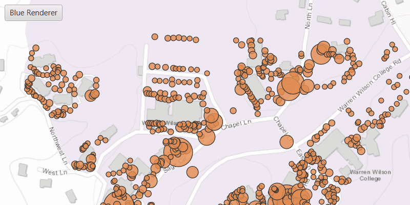
Use the 'Blue Renderer' button to change the renderer on the feature layer. The original renderer displays orange circles, the diameters of which are proportional to carbon storage of each tree. When the blue renderer in this sample is applied, it displays the location of the trees simply as blue points.
How it works
- Create a
ServiceFeatureTablefrom a URL. - Create a
FeatureLayerfrom the service feature table. - Create a new renderer (in this case, a
SimpleRenderer). - Change the feature layer's renderer using
FeatureLayer.setRenderer(SimpleRenderer).
Relevant API
- FeatureLayer
- ServiceFeatureTable
- SimpleRenderer
About the data
This sample displays a feature layer in Warren Wilson College, North Carolina, showing carbon storage of trees on campus. The size of each circle is proportional to that particular tree's carbon storage total.
Tags
feature layer, renderer, visualization
Sample Code
/*
* Copyright 2017 Esri.
*
* Licensed under the Apache License, Version 2.0 (the "License"); you may not
* use this file except in compliance with the License. You may obtain a copy of
* the License at
*
* http://www.apache.org/licenses/LICENSE-2.0
*
* Unless required by applicable law or agreed to in writing, software
* distributed under the License is distributed on an "AS IS" BASIS, WITHOUT
* WARRANTIES OR CONDITIONS OF ANY KIND, either express or implied. See the
* License for the specific language governing permissions and limitations under
* the License.
*/
package com.esri.samples.change_feature_layer_renderer;
import javafx.application.Application;
import javafx.geometry.Insets;
import javafx.geometry.Pos;
import javafx.scene.Scene;
import javafx.scene.control.Alert;
import javafx.scene.control.ToggleButton;
import javafx.scene.layout.StackPane;
import javafx.scene.paint.Color;
import javafx.stage.Stage;
import com.esri.arcgisruntime.ArcGISRuntimeEnvironment;
import com.esri.arcgisruntime.data.ServiceFeatureTable;
import com.esri.arcgisruntime.geometry.Envelope;
import com.esri.arcgisruntime.geometry.Point;
import com.esri.arcgisruntime.layers.FeatureLayer;
import com.esri.arcgisruntime.loadable.LoadStatus;
import com.esri.arcgisruntime.mapping.ArcGISMap;
import com.esri.arcgisruntime.mapping.BasemapStyle;
import com.esri.arcgisruntime.mapping.Viewpoint;
import com.esri.arcgisruntime.mapping.view.MapView;
import com.esri.arcgisruntime.symbology.SimpleMarkerSymbol;
import com.esri.arcgisruntime.symbology.SimpleRenderer;
public class ChangeFeatureLayerRendererSample extends Application {
private MapView mapView;
private FeatureLayer featureLayer;
private final static String FEATURE_SERVICE_URL =
"https://services.arcgis.com/V6ZHFr6zdgNZuVG0/arcgis/rest/services/Landscape_Trees/FeatureServer/0";
@Override
public void start(Stage stage) {
try {
// create stack pane and application scene
StackPane stackPane = new StackPane();
Scene scene = new Scene(stackPane);
scene.getStylesheets().add(getClass().getResource("/change_feature_layer_renderer/style.css").toExternalForm());
// set title, size, and add scene to stage
stage.setTitle("Change Feature Layer Renderer Sample");
stage.setWidth(800);
stage.setHeight(700);
stage.setScene(scene);
stage.show();
// authentication with an API key or named user is required to access basemaps and other location services
String yourAPIKey = System.getProperty("apiKey");
ArcGISRuntimeEnvironment.setApiKey(yourAPIKey);
// create a marker symbol renderer with a blue circle
SimpleMarkerSymbol markerSymbol = new SimpleMarkerSymbol(SimpleMarkerSymbol.Style.CIRCLE, Color.BLUE, 5 );
SimpleRenderer blueRenderer = new SimpleRenderer(markerSymbol);
// create renderer toggle switch
ToggleButton rendererSwitch = new ToggleButton();
rendererSwitch.setText("Blue Renderer");
// set the render if the switch is selected
rendererSwitch.selectedProperty().addListener((observable, oldValue, newValue) -> {
if (rendererSwitch.isSelected()) {
featureLayer.setRenderer(blueRenderer);
rendererSwitch.setText("Show Original Renderer");
} else {
// reset the renderer if not selected
featureLayer.resetRenderer();
rendererSwitch.setText("Blue Renderer");
}
});
// create a map with the topographic basemap style
final ArcGISMap map = new ArcGISMap(BasemapStyle.ARCGIS_TOPOGRAPHIC);
// create a map view and set the map to it
mapView = new MapView();
mapView.setMap(map);
// set a viewpoint on the map view
Point topLeftPoint = new Point(-9177811, 4247000);
Point bottomRightPoint = new Point(-9176791, 4247784);
mapView.setViewpoint(new Viewpoint(new Envelope(topLeftPoint, bottomRightPoint)));
// create a service feature table using the url
final ServiceFeatureTable featureTable = new ServiceFeatureTable(FEATURE_SERVICE_URL);
// create a feature layer from the service feature table
featureLayer = new FeatureLayer(featureTable);
// wait for the feature layer to load
featureLayer.loadAsync();
featureLayer.addDoneLoadingListener(()->{
if (featureLayer.getLoadStatus() == LoadStatus.LOADED) {
// add feature layer to ArcGISMap
map.getOperationalLayers().add(featureLayer);
} else {
new Alert(Alert.AlertType.ERROR, "Error loading Feature Table from service").show();
}
});
// add the map view and control panel to stack pane
stackPane.getChildren().addAll(mapView, rendererSwitch);
StackPane.setAlignment(rendererSwitch, Pos.TOP_LEFT);
StackPane.setMargin(rendererSwitch, new Insets(10, 0, 0, 10));
} catch (Exception e) {
// on any error, display the stack trace
e.printStackTrace();
}
}
/**
* Stops and releases all resources used in application.
*/
@Override
public void stop() {
if (mapView != null) {
mapView.dispose();
}
}
/**
* Opens and runs application.
*
* @param args arguments passed to this application
*/
public static void main(String[] args) {
Application.launch(args);
}
}