Display annotation from a feature service URL.
Use case
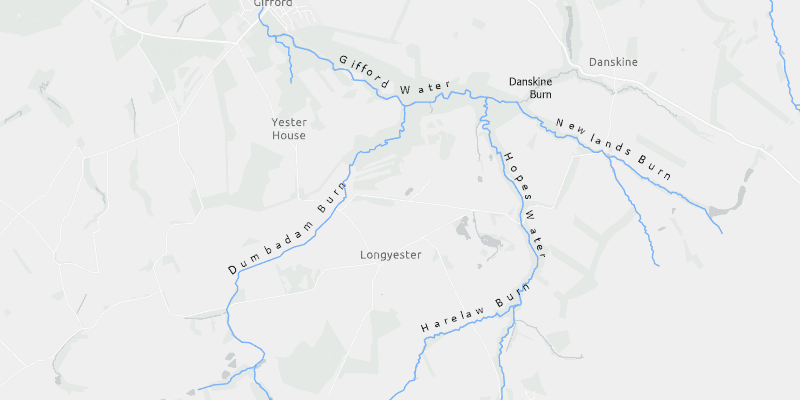
Annotation is useful for displaying text that you don't want to move or resize when the map is panned or zoomed (unlike labels which will move and resize). You can use annotation to place text at a fixed size, position, orientation, font, and so on. You may choose to do this for cartographic reasons or because the exact placement of the text is important.
How to use the sample
Pan and zoom to see names of waters and burns in a small region of Scotland.
How it works
- Create an
ArcGISMapwith a light gray canvas and a viewpoint near the data. - Create an
AnnotationLayerfrom a feature service URL. - Add both layers to the operational layers of the map and add it to a
MapView.
Relevant API
- AnnotationLayer
- FeatureLayer
About the data
Data derived from Ordnance Survey OpenRivers. Contains OS data © Crown copyright and database right 2018.
The annotation layer contains two sublayers of rivers in East Lothian, Scotland, which were set by the author to only be visible within the following scale ranges:
- Water (1:50,000 - 1:100,000) - A large stream, as defined in the Scots language
- Burn (1:25,000 - 1:75,000) - A brook or small stream, as defined in the Scots language
Additional information
Annotation is only supported from feature services hosted on an ArcGIS Enterprise server.
Tags
annotation, cartography, labels, placement, reference scale, text, utility
Sample Code
/*
* Copyright 2020 Esri.
*
* Licensed under the Apache License, Version 2.0 (the "License"); you may not
* use this file except in compliance with the License. You may obtain a copy of
* the License at
*
* http://www.apache.org/licenses/LICENSE-2.0
*
* Unless required by applicable law or agreed to in writing, software
* distributed under the License is distributed on an "AS IS" BASIS, WITHOUT
* WARRANTIES OR CONDITIONS OF ANY KIND, either express or implied. See the
* License for the specific language governing permissions and limitations under
* the License.
*/
package com.esri.samples.display_annotation;
import javafx.application.Application;
import javafx.scene.Scene;
import javafx.scene.control.Alert;
import javafx.scene.layout.StackPane;
import javafx.stage.Stage;
import com.esri.arcgisruntime.ArcGISRuntimeEnvironment;
import com.esri.arcgisruntime.data.ServiceFeatureTable;
import com.esri.arcgisruntime.layers.AnnotationLayer;
import com.esri.arcgisruntime.layers.FeatureLayer;
import com.esri.arcgisruntime.loadable.LoadStatus;
import com.esri.arcgisruntime.mapping.ArcGISMap;
import com.esri.arcgisruntime.mapping.BasemapStyle;
import com.esri.arcgisruntime.mapping.Viewpoint;
import com.esri.arcgisruntime.mapping.view.MapView;
public class DisplayAnnotationSample extends Application {
private MapView mapView;
@Override
public void start(Stage stage) {
try {
// create stack pane and application scene
StackPane stackPane = new StackPane();
Scene scene = new Scene(stackPane);
// set title, size, and add scene to stage
stage.setTitle("Display Annotation Sample");
stage.setWidth(800);
stage.setHeight(700);
stage.setScene(scene);
stage.show();
// authentication with an API key or named user is required to access basemaps and other location services
String yourAPIKey = System.getProperty("apiKey");
ArcGISRuntimeEnvironment.setApiKey(yourAPIKey);
// create a map with the light gray basemap style
ArcGISMap map = new ArcGISMap(BasemapStyle.ARCGIS_LIGHT_GRAY);
// create a map view and set the map to it
mapView = new MapView();
mapView.setMap(map);
// set a viewpoint on the map view
mapView.setViewpoint(new Viewpoint(55.882436, -2.725610, 72223));
// create a feature layer from a feature service
FeatureLayer riverFeatureLayer = new FeatureLayer(new ServiceFeatureTable("https://services1.arcgis.com/6677msI40mnLuuLr/arcgis/rest/services/East_Lothian_Rivers/FeatureServer/0"));
// add the feature layer to the map
map.getOperationalLayers().add(riverFeatureLayer);
// create an annotation layer from a feature service
AnnotationLayer annotationLayer = new AnnotationLayer("https://sampleserver6.arcgisonline.com/arcgis/rest/services/RiversAnnotation/FeatureServer/0");
// add the annotation layer to the map
map.getOperationalLayers().add(annotationLayer);
// show alert if layer fails to load
riverFeatureLayer.addDoneLoadingListener(() -> {
if (riverFeatureLayer.getLoadStatus() != LoadStatus.LOADED) {
new Alert(Alert.AlertType.ERROR, "Error loading Feature Layer.").show();
}
});
// add a done loading listener, with a runnable that gets triggered asynchronously when the feature layer has loaded
// check for the load status of the layer and if it hasn't loaded, report an error
annotationLayer.addDoneLoadingListener(() -> {
if (annotationLayer.getLoadStatus() != LoadStatus.LOADED) {
new Alert(Alert.AlertType.ERROR, "Error loading Annotation Layer.").show();
}
});
// add the map view to stack pane
stackPane.getChildren().add(mapView);
} catch (Exception e) {
e.printStackTrace();
}
}
/**
* Stops and releases all resources used in application.
*/
@Override
public void stop() {
if (mapView != null) {
mapView.dispose();
}
}
/**
* Opens and runs application.
*
* @param args arguments passed to this application
*/
public static void main(String[] args) {
Application.launch(args);
}
}