Identify a graphic to get further information about the object.
Use case
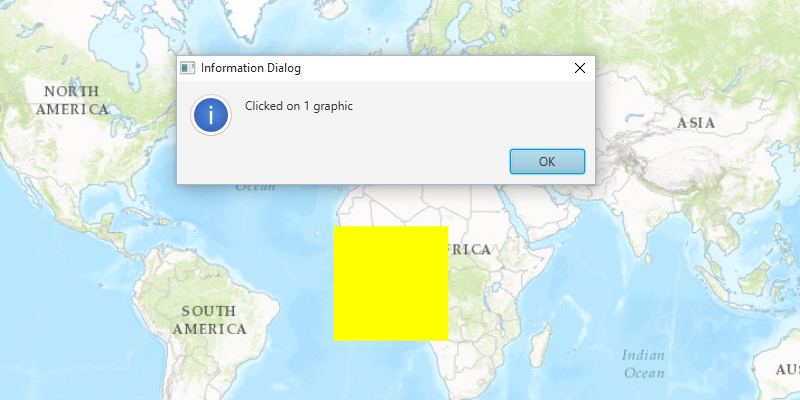
A user may wish to select a graphic on a map to view relevant information about it.
How to use the sample
Select a graphic to identify it. You will see an alert message displayed.
How it works
- Use the
.setOnMouseClicked()method to listen to clicks on aMapView. - When the map view is clicked, use the event to create a
Pointfrom the location clicked on the map. - Identify the graphic on the map view with
MapView.identifyGraphicsOverlayAsync(graphicsOverlay, pointClicked, tolerance, max results).
Relevant API
- Graphic
- GraphicsOverlay
- MapView
- Point
Tags
graphics, identify
Sample Code
/* * Copyright 2022 Esri. * * Licensed under the Apache License, Version 2.0 (the "License"); * you may not use this file except in compliance with the License. * You may obtain a copy of the License at * * http://www.apache.org/licenses/LICENSE-2.0 * * Unless required by applicable law or agreed to in writing, software * distributed under the License is distributed on an "AS IS" BASIS, * WITHOUT WARRANTIES OR CONDITIONS OF ANY KIND, either express or implied. * See the License for the specific language governing permissions and * limitations under the License. */module com.esri.samples.identify_graphics {  // require ArcGIS Maps SDK for Java module  requires com.esri.arcgisruntime;
  // handle SLF4J http://www.slf4j.org/codes.html#StaticLoggerBinder  requires org.slf4j.nop;
  // require JavaFX modules that the application uses  requires javafx.graphics;  requires javafx.controls;
  exports com.esri.samples.identify_graphics;}
/* * Copyright 2017 Esri. * * Licensed under the Apache License, Version 2.0 (the "License"); you may not * use this file except in compliance with the License. You may obtain a copy of * the License at * * http://www.apache.org/licenses/LICENSE-2.0 * * Unless required by applicable law or agreed to in writing, software * distributed under the License is distributed on an "AS IS" BASIS, WITHOUT * WARRANTIES OR CONDITIONS OF ANY KIND, either express or implied. See the * License for the specific language governing permissions and limitations under * the License. */
package com.esri.samples.identify_graphics;
import java.util.Arrays;import java.util.List;
import javafx.application.Application;import javafx.application.Platform;import javafx.geometry.Point2D;import javafx.scene.Scene;import javafx.scene.control.Alert;import javafx.scene.control.Alert.AlertType;import javafx.scene.input.MouseButton;import javafx.scene.layout.StackPane;import javafx.scene.paint.Color;import javafx.stage.Stage;
import com.esri.arcgisruntime.ArcGISRuntimeEnvironment;import com.esri.arcgisruntime.concurrent.ListenableFuture;import com.esri.arcgisruntime.geometry.Point;import com.esri.arcgisruntime.geometry.PointCollection;import com.esri.arcgisruntime.geometry.Polygon;import com.esri.arcgisruntime.mapping.ArcGISMap;import com.esri.arcgisruntime.mapping.BasemapStyle;import com.esri.arcgisruntime.mapping.view.Graphic;import com.esri.arcgisruntime.mapping.view.GraphicsOverlay;import com.esri.arcgisruntime.mapping.view.IdentifyGraphicsOverlayResult;import com.esri.arcgisruntime.mapping.view.MapView;import com.esri.arcgisruntime.symbology.SimpleFillSymbol;
public class IdentifyGraphicsSample extends Application {
private MapView mapView; private GraphicsOverlay graphicsOverlay; private ListenableFuture<IdentifyGraphicsOverlayResult> identifyGraphics;
@Override public void start(Stage stage) {
try { // create stack pane and application scene StackPane stackPane = new StackPane(); Scene scene = new Scene(stackPane);
// set title, size, and add scene to stage stage.setTitle("Identify Graphics Sample"); stage.setWidth(800); stage.setHeight(700); stage.setScene(scene); stage.show();
// authentication with an API key or named user is required to access basemaps and other location services String yourAPIKey = System.getProperty("apiKey"); ArcGISRuntimeEnvironment.setApiKey(yourAPIKey);
// create a map with the topographic basemap style final ArcGISMap map = new ArcGISMap(BasemapStyle.ARCGIS_TOPOGRAPHIC);
// create a map view and set the map to it mapView = new MapView(); mapView.setMap(map);
// create a graphics overlay graphicsOverlay = new GraphicsOverlay();
// create polygon var pointsPoly = new PointCollection(mapView.getSpatialReference()); pointsPoly.addAll(Arrays.asList( new Point(-20E5, 20E5), new Point(20E5, 20E5), new Point(20E5, -20E5), new Point(-20E5, -20E5))); var fillSymbol = new SimpleFillSymbol(SimpleFillSymbol.Style.SOLID, Color.YELLOW, null); var polygon = new Polygon(pointsPoly); // create graphic from polygon and symbol var polygonGraphic = new Graphic(polygon, fillSymbol); // add the polygon graphic to the graphics overlay graphicsOverlay.getGraphics().add(polygonGraphic);
// add graphics overlay to the map view mapView.getGraphicsOverlays().add(graphicsOverlay);
mapView.setOnMouseClicked(e -> { if (e.getButton() == MouseButton.PRIMARY && e.isStillSincePress()) { // create a point from location clicked Point2D mapViewPoint = new Point2D(e.getX(), e.getY());
// identify graphics on the graphics overlay identifyGraphics = mapView.identifyGraphicsOverlayAsync(graphicsOverlay, mapViewPoint, 10, false);
identifyGraphics.addDoneListener(() -> Platform.runLater(this::createGraphicDialog)); } });
// add the map view to stack pane stackPane.getChildren().add(mapView);
} catch (Exception e) { // on any error, print stack trace e.printStackTrace(); } }
/** * Indicates when a graphic is clicked by showing an Alert. */ private void createGraphicDialog() {
try { // get the list of graphics returned by identify IdentifyGraphicsOverlayResult result = identifyGraphics.get(); List<Graphic> graphics = result.getGraphics();
if (!graphics.isEmpty()) { // show an alert dialog box if a graphic was returned var dialog = new Alert(AlertType.INFORMATION); dialog.initOwner(mapView.getScene().getWindow()); dialog.setHeaderText(null); dialog.setTitle("Information Dialog Sample"); dialog.setContentText("Clicked on " + graphics.size() + " graphic"); dialog.showAndWait(); } } catch (Exception e) { // on any error, display the stack trace e.printStackTrace(); } }
/** * Stops and releases all resources used in application. */ @Override public void stop() {
if (mapView != null) { mapView.dispose(); } }
/** * Opens and runs application. * * @param args arguments passed to this application */ public static void main(String[] args) {
Application.launch(args); }
}