Show a line of sight between two moving objects.
Use case
A line of sight between GeoElements (i.e. observer and target) will not remain constant whilst one or both are on the move.
A GeoElementLineOfSight is therefore useful in cases where visibility between two GeoElements requires monitoring over a period of time in a partially obstructed field of view
(such as buildings in a city).
How to use the sample
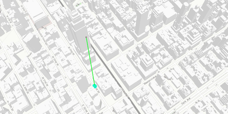
A line of sight will display between a point on the Empire State Building (observer) and a taxi (target). The taxi will drive around a block and the line of sight should automatically update. The taxi will be highlighted when it is visible. You can change the observer height with the slider to see how it affects the target’s visibility.
How it works
- Instantiate an
AnalysisOverlayand add it to theSceneView’s analysis overlays collection. - Instantiate a
GeoElementLineOfSight, passing in observer and targetGeoElements (features or graphics). Add the line of sight to the analysis overlay’s analyses collection. - To get the target visibility when it changes, react to the target visibility changing on the
GeoElementLineOfSightinstance.
Relevant API
- AnalysisOverlay
- GeoElementLineOfSight
- LineOfSight.getTargetVisibility
Tags
3D, line of sight, visibility, visibility analysis
Sample Code
/* * Copyright 2022 Esri. * * Licensed under the Apache License, Version 2.0 (the "License"); * you may not use this file except in compliance with the License. * You may obtain a copy of the License at * * http://www.apache.org/licenses/LICENSE-2.0 * * Unless required by applicable law or agreed to in writing, software * distributed under the License is distributed on an "AS IS" BASIS, * WITHOUT WARRANTIES OR CONDITIONS OF ANY KIND, either express or implied. * See the License for the specific language governing permissions and * limitations under the License. */
module com.esri.samples.line_of_sight_geoelement {  // require ArcGIS Maps SDK for Java module  requires com.esri.arcgisruntime;
  // handle SLF4J http://www.slf4j.org/codes.html#StaticLoggerBinder  requires org.slf4j.nop;
  // require JavaFX modules that the application uses  requires javafx.graphics;  requires javafx.controls;
  exports com.esri.samples.line_of_sight_geoelement;}
/* * Copyright 2018 Esri. * * Licensed under the Apache License, Version 2.0 (the "License"); you may not * use this file except in compliance with the License. You may obtain a copy of * the License at * * http://www.apache.org/licenses/LICENSE-2.0 * * Unless required by applicable law or agreed to in writing, software * distributed under the License is distributed on an "AS IS" BASIS, WITHOUT * WARRANTIES OR CONDITIONS OF ANY KIND, either express or implied. See the * License for the specific language governing permissions and limitations under * the License. */
package com.esri.samples.line_of_sight_geoelement;
import java.io.File;import java.util.Arrays;import java.util.List;
import javafx.animation.KeyFrame;import javafx.animation.Timeline;import javafx.application.Application;import javafx.geometry.Insets;import javafx.geometry.Orientation;import javafx.geometry.Pos;import javafx.scene.Scene;import javafx.scene.control.Slider;import javafx.scene.layout.Background;import javafx.scene.layout.BackgroundFill;import javafx.scene.layout.CornerRadii;import javafx.scene.layout.StackPane;import javafx.scene.layout.VBox;import javafx.scene.paint.Color;import javafx.scene.paint.Paint;import javafx.stage.Stage;import javafx.util.Duration;
import com.esri.arcgisruntime.ArcGISRuntimeEnvironment;import com.esri.arcgisruntime.geoanalysis.GeoElementLineOfSight;import com.esri.arcgisruntime.geoanalysis.LineOfSight;import com.esri.arcgisruntime.geometry.AngularUnit;import com.esri.arcgisruntime.geometry.AngularUnitId;import com.esri.arcgisruntime.geometry.GeodeticCurveType;import com.esri.arcgisruntime.geometry.GeodeticDistanceResult;import com.esri.arcgisruntime.geometry.GeometryEngine;import com.esri.arcgisruntime.geometry.LinearUnit;import com.esri.arcgisruntime.geometry.LinearUnitId;import com.esri.arcgisruntime.geometry.Point;import com.esri.arcgisruntime.geometry.PointBuilder;import com.esri.arcgisruntime.geometry.SpatialReferences;import com.esri.arcgisruntime.layers.ArcGISSceneLayer;import com.esri.arcgisruntime.mapping.ArcGISScene;import com.esri.arcgisruntime.mapping.ArcGISTiledElevationSource;import com.esri.arcgisruntime.mapping.BasemapStyle;import com.esri.arcgisruntime.mapping.Surface;import com.esri.arcgisruntime.mapping.view.AnalysisOverlay;import com.esri.arcgisruntime.mapping.view.Camera;import com.esri.arcgisruntime.mapping.view.Graphic;import com.esri.arcgisruntime.mapping.view.GraphicsOverlay;import com.esri.arcgisruntime.mapping.view.LayerSceneProperties;import com.esri.arcgisruntime.mapping.view.SceneView;import com.esri.arcgisruntime.symbology.ModelSceneSymbol;import com.esri.arcgisruntime.symbology.Renderer;import com.esri.arcgisruntime.symbology.SceneSymbol;import com.esri.arcgisruntime.symbology.SimpleMarkerSymbol;import com.esri.arcgisruntime.symbology.SimpleRenderer;
public class LineOfSightGeoElementSample extends Application {
private SceneView sceneView; private List<Point> waypoints; private int waypointIndex = 0; private Timeline animation; private Graphic taxi;
private static final LinearUnit METERS = new LinearUnit(LinearUnitId.METERS); private static final AngularUnit DEGREES = new AngularUnit(AngularUnitId.DEGREES);
@Override public void start(Stage stage) {
try {
// create stack pane and JavaFX app scene StackPane stackPane = new StackPane(); Scene fxScene = new Scene(stackPane); fxScene.getStylesheets().add(getClass().getResource("/line_of_sight_geoelement/style.css").toExternalForm());
// set title, size, and add JavaFX scene to stage stage.setTitle("Line of Sight GeoElement Sample"); stage.setWidth(800); stage.setHeight(700); stage.setScene(fxScene); stage.show();
// authentication with an API key or named user is required to access basemaps and other location services String yourAPIKey = System.getProperty("apiKey"); ArcGISRuntimeEnvironment.setApiKey(yourAPIKey);
// create a scene with a basemap style ArcGISScene scene = new ArcGISScene(BasemapStyle.ARCGIS_TOPOGRAPHIC);
// add the SceneView to the stack pane sceneView = new SceneView(); sceneView.setArcGISScene(scene); stackPane.getChildren().add(sceneView);
// add base surface for elevation data Surface surface = new Surface(); surface.getElevationSources().add(new ArcGISTiledElevationSource("https://elevation3d.arcgis.com/arcgis/rest/services/WorldElevation3D/Terrain3D/ImageServer")); scene.setBaseSurface(surface);
// add buildings from New York City String buildingsURL = "https://tiles.arcgis.com/tiles/z2tnIkrLQ2BRzr6P/arcgis/rest/services/Buildings_NewYork_v18/SceneServer/layers/0"; ArcGISSceneLayer buildings = new ArcGISSceneLayer(buildingsURL); scene.getOperationalLayers().add(buildings);
// create a graphics overlay for the graphics GraphicsOverlay graphicsOverlay = new GraphicsOverlay(); graphicsOverlay.getSceneProperties().setSurfacePlacement(LayerSceneProperties.SurfacePlacement.RELATIVE); sceneView.getGraphicsOverlays().add(graphicsOverlay);
// set up a heading expression to handle graphic rotation SimpleRenderer renderer3D = new SimpleRenderer(); Renderer.SceneProperties renderProperties = renderer3D.getSceneProperties(); renderProperties.setHeadingExpression("[HEADING]"); graphicsOverlay.setRenderer(renderer3D);
// create a point graph near the Empire State Building to be the observer Point observationPoint = new Point(-73.9853, 40.7484, 200, SpatialReferences.getWgs84()); Graphic observer = new Graphic(observationPoint, new SimpleMarkerSymbol(SimpleMarkerSymbol.Style.CIRCLE, Color.RED, 5)); graphicsOverlay.getGraphics().add(observer);
// create a slider to change the observer's Z value Slider heightSlider = new Slider(150, 300, 200); heightSlider.setMaxSize(30, 150); heightSlider.setShowTickLabels(true); heightSlider.setOrientation(Orientation.VERTICAL); heightSlider.valueProperty().addListener(e -> { PointBuilder pointBuilder = new PointBuilder((Point) observer.getGeometry()); pointBuilder.setZ(heightSlider.getValue()); observer.setGeometry(pointBuilder.toGeometry()); });
// show a background behind the slider VBox controlsVBox = new VBox(6); controlsVBox.setBackground(new Background(new BackgroundFill(Paint.valueOf("rgba(0,0,0,0.3)"), CornerRadii.EMPTY, Insets.EMPTY))); controlsVBox.setPadding(new Insets(10.0)); controlsVBox.setMaxSize(50, 160); controlsVBox.getStyleClass().add("panel-region"); controlsVBox.getChildren().add(heightSlider); stackPane.getChildren().add(controlsVBox); StackPane.setAlignment(controlsVBox, Pos.TOP_LEFT); StackPane.setMargin(controlsVBox, new Insets(10, 0, 0, 10));
// create waypoints around a block for the taxi to drive to waypoints = Arrays.asList( new Point(-73.984513, 40.748469, SpatialReferences.getWgs84()), new Point(-73.985068, 40.747786, SpatialReferences.getWgs84()), new Point(-73.983452, 40.747091, SpatialReferences.getWgs84()), new Point(-73.982961, 40.747762, SpatialReferences.getWgs84()) );
// create a graphic of a taxi to be the target String modelURI = new File(System.getProperty("data.dir"), "./samples-data/dolmus_3ds/dolmus.3ds").getAbsolutePath(); ModelSceneSymbol taxiSymbol = new ModelSceneSymbol(modelURI, 1.0); taxiSymbol.setAnchorPosition(SceneSymbol.AnchorPosition.BOTTOM); taxiSymbol.loadAsync(); taxi = new Graphic(waypoints.get(0), taxiSymbol); taxi.getAttributes().put("HEADING", 0.0); graphicsOverlay.getGraphics().add(taxi);
// create an analysis overlay to hold the line of sight AnalysisOverlay analysisOverlay = new AnalysisOverlay(); sceneView.getAnalysisOverlays().add(analysisOverlay);
// create a line of sight between the two graphics and add it to the analysis overlay GeoElementLineOfSight lineOfSight = new GeoElementLineOfSight(observer, taxi); analysisOverlay.getAnalyses().add(lineOfSight);
// select (highlight) the taxi when the line of sight target visibility changes to visible lineOfSight.addTargetVisibilityChangedListener(targetVisibilityChangedEvent -> taxi.setSelected(targetVisibilityChangedEvent.getTargetVisibility() == LineOfSight.TargetVisibility.VISIBLE) );
// create a timeline to animate the taxi driving around the block animation = new Timeline(); animation.setCycleCount(-1); animation.getKeyFrames().add(new KeyFrame(Duration.millis(100), e -> animate())); animation.play();
// zoom to show the observer Camera camera = new Camera((Point) observer.getGeometry(), 700, -30, 45, 0); sceneView.setViewpointCamera(camera);
} catch (Exception e) { // on any error, display the stack trace. e.printStackTrace(); } }
/** * Moves the taxi toward the current waypoint a short distance. */ private void animate() { Point waypoint = waypoints.get(waypointIndex); // get current location and distance from waypoint Point location = (Point) taxi.getGeometry(); GeodeticDistanceResult distance = GeometryEngine.distanceGeodetic(location, waypoint, METERS, DEGREES, GeodeticCurveType.GEODESIC);
// move toward waypoint a short distance location = GeometryEngine.moveGeodetic(location, 1.0, METERS, distance.getAzimuth1(), DEGREES, GeodeticCurveType.GEODESIC); taxi.setGeometry(location);
// rotate to the waypoint taxi.getAttributes().put("HEADING", distance.getAzimuth1());
// reached waypoint, move to next waypoint if (distance.getDistance() <= 2) { waypointIndex = (waypointIndex + 1) % waypoints.size(); } }
/** * Stops and releases all resources used in application. */ @Override public void stop() {
// stop the animation animation.stop();
if (sceneView != null) { sceneView.dispose(); } }
/** * Opens and runs application. * * @param args arguments passed to this application */ public static void main(String[] args) {
Application.launch(args); }
}