Change a graphic's symbol, attributes, and geometry.
Use case
A field worker may want to update a graphic's properties to adjust which real-world elements it represents in their map.
How to use the sample
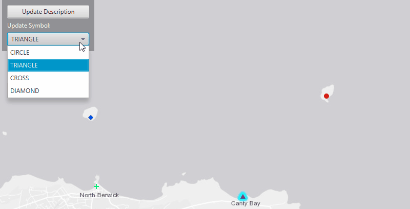
To update the graphic's location, click on a graphic and then drag it to a new location. Use the "Update Description" button to provide a new description for the graphic, and use the "Update Symbol" drop down menu to choose a new symbol. Click away from the graphic to de-select it.
How it works
- Capture clicks on the
MapViewby using.setOnMouseClicked(). Then use the event to create aPointfrom the clicked location. - Identify the clicked graphics using
MapView.identifyGraphicsOverlayAsync(graphicsOverlay, pointClicked, tolerance, max results). - To select a clicked graphics, iterate through the list of graphics returned by the identification method, and set each graphic's selection property to
true. - To update a graphic's location, capture drags on the map view using
.setOnMouseDragged(), and useGraphic.setGeometry(point)to modify the graphic's geometry from the dragged location. - To update a graphic's attribute, get the attributes of the selected graphic and set the
DESCRIPTIONkey with the desired string value usingGraphic.getAttributes().put("DESCRIPTION",). - To update graphic's symbol simply assign that symbol to the selected graphic using
Graphic.setSymbol(SimpleMarkerSymbol).
Additional information
A graphic's geometry is its location on a map. The symbol controls how a graphic will be displayed to a map. The attributes store information about the graphic in key value pairs.
Relevant API
- ArcGISMap
- Graphic
- GraphicsOverlay
- MapView
- SimpleMarkerSymbol
Tags
location, description, symbol, adjust, modify, attributes, geometry, marker
Sample Code
UpdateGraphicsSample.java
/*
* Copyright 2017 Esri.
*
* Licensed under the Apache License, Version 2.0 (the "License"); you may not
* use this file except in compliance with the License. You may obtain a copy of
* the License at
*
* http://www.apache.org/licenses/LICENSE-2.0
*
* Unless required by applicable law or agreed to in writing, software
* distributed under the License is distributed on an "AS IS" BASIS, WITHOUT
* WARRANTIES OR CONDITIONS OF ANY KIND, either express or implied. See the
* License for the specific language governing permissions and limitations under
* the License.
*/
package com.esri.samples.update_graphics;
import java.util.ArrayList;
import java.util.List;
import java.util.Optional;
import javafx.application.Application;
import javafx.geometry.Insets;
import javafx.geometry.Point2D;
import javafx.geometry.Pos;
import javafx.scene.Cursor;
import javafx.scene.Scene;
import javafx.scene.control.Alert;
import javafx.scene.control.Button;
import javafx.scene.control.ComboBox;
import javafx.scene.control.Label;
import javafx.scene.control.TextInputDialog;
import javafx.scene.input.MouseButton;
import javafx.scene.layout.Background;
import javafx.scene.layout.BackgroundFill;
import javafx.scene.layout.CornerRadii;
import javafx.scene.layout.StackPane;
import javafx.scene.layout.VBox;
import javafx.scene.paint.Color;
import javafx.scene.paint.Paint;
import javafx.stage.Stage;
import com.esri.arcgisruntime.ArcGISRuntimeEnvironment;
import com.esri.arcgisruntime.concurrent.ListenableFuture;
import com.esri.arcgisruntime.geometry.Point;
import com.esri.arcgisruntime.geometry.SpatialReference;
import com.esri.arcgisruntime.geometry.SpatialReferences;
import com.esri.arcgisruntime.mapping.ArcGISMap;
import com.esri.arcgisruntime.mapping.BasemapStyle;
import com.esri.arcgisruntime.mapping.Viewpoint;
import com.esri.arcgisruntime.mapping.view.Graphic;
import com.esri.arcgisruntime.mapping.view.GraphicsOverlay;
import com.esri.arcgisruntime.mapping.view.IdentifyGraphicsOverlayResult;
import com.esri.arcgisruntime.mapping.view.MapView;
import com.esri.arcgisruntime.symbology.SimpleMarkerSymbol;
public class UpdateGraphicsSample extends Application {
private List<SimpleMarkerSymbol> markers;
private Button updateDescriptionButton;
private ComboBox<String> symbolBox;
private MapView mapView;
private Graphic identifiedGraphic;
private GraphicsOverlay graphicsOverlay;
private Point2D mapViewPoint;
@Override
public void start(Stage stage) {
try {
// create stack pane and application scene
StackPane stackPane = new StackPane();
Scene scene = new Scene(stackPane);
scene.getStylesheets().add(getClass().getResource("/update_graphics/style.css").toExternalForm());
// set title, size, and add scene to stage
stage.setTitle("Update Graphics Sample");
stage.setWidth(800);
stage.setHeight(700);
stage.setScene(scene);
stage.show();
// authentication with an API key or named user is required to access basemaps and other location services
String yourAPIKey = System.getProperty("apiKey");
ArcGISRuntimeEnvironment.setApiKey(yourAPIKey);
// create a control panel
VBox controlsVBox = new VBox(6);
controlsVBox.setBackground(new Background(new BackgroundFill(Paint.valueOf("rgba(0,0,0,0.3)"), CornerRadii.EMPTY,
Insets.EMPTY)));
controlsVBox.setPadding(new Insets(10.0));
controlsVBox.setMaxSize(180, 100);
controlsVBox.getStyleClass().add("panel-region");
// create buttons for user interaction
updateDescriptionButton = new Button("Update Description");
updateDescriptionButton.setMaxWidth(Double.MAX_VALUE);
updateDescriptionButton.setDisable(true);
// create combo box for the UI
Label symbolLabel = new Label("Update Symbol:");
symbolLabel.getStyleClass().add("panel-label");
symbolBox = new ComboBox<>();
symbolBox.getItems().addAll("CIRCLE", "TRIANGLE", "CROSS", "DIAMOND");
symbolBox.getSelectionModel().selectFirst();
symbolBox.setMaxWidth(Double.MAX_VALUE);
symbolBox.setDisable(true);
// set the symbol of the graphic
symbolBox.showingProperty().addListener((obs, wasShowing, isShowing) -> {
if (identifiedGraphic.isSelected() && !isShowing) {
identifiedGraphic.setSymbol(markers.get(symbolBox.getSelectionModel().getSelectedIndex()));
}
});
// add the button, label, and combo box to the control panel
controlsVBox.getChildren().addAll(updateDescriptionButton, symbolLabel, symbolBox);
// create a map with the light gray basemap style
ArcGISMap map = new ArcGISMap(BasemapStyle.ARCGIS_LIGHT_GRAY);
// create a map view and set the map to it
mapView = new MapView();
mapView.setMap(map);
// set a viewpoint on the map view
mapView.setViewpoint(new Viewpoint(56.075844, -2.681572, 70000));
// create a graphics overlay
graphicsOverlay = new GraphicsOverlay();
// add graphics overlay to the map view
mapView.getGraphicsOverlays().add(graphicsOverlay);
// create default graphics for graphics overlay
createGraphics();
updateDescriptionButton.setOnAction(e -> {
if (identifiedGraphic.isSelected()) {
// get attributes from selected graphic
java.util.Map<String, Object> attributes = identifiedGraphic.getAttributes();
// create input dialog
TextInputDialog dialog = new TextInputDialog();
dialog.setTitle(attributes.get("NAME").toString());
dialog.setGraphic(null);
dialog.setHeaderText(attributes.get("DESCRIPTION").toString());
dialog.setContentText("New Description");
// set the graphic's description is text entered
Optional<String> result = dialog.showAndWait();
result.ifPresent(text -> {
if (!text.isEmpty()) {
attributes.put("DESCRIPTION", text);
}
});
}
});
mapView.setOnMouseClicked(e -> {
if (e.getButton() == MouseButton.PRIMARY && e.isStillSincePress()) {
// set the cursor to default
mapView.setCursor(Cursor.DEFAULT);
// clear any selected graphic
graphicsOverlay.clearSelection();
// create a point where the user clicked
mapViewPoint = new Point2D(e.getX(), e.getY());
// identify graphics on the graphics overlay
ListenableFuture<IdentifyGraphicsOverlayResult> identifyGraphics =
mapView.identifyGraphicsOverlayAsync(graphicsOverlay, mapViewPoint, 10, false);
identifyGraphics.addDoneListener(() -> {
try {
if (!identifyGraphics.get().getGraphics().isEmpty()) {
// get the first identified graphic
identifiedGraphic = identifyGraphics.get().getGraphics().get(0);
// select the identified graphic
identifiedGraphic.setSelected(true);
// update the drop down box with the identified graphic's current symbol
String style = ((SimpleMarkerSymbol) identifiedGraphic.getSymbol()).getStyle().toString();
symbolBox.getSelectionModel().select(style);
// show the UI
disableUI(false);
// enable dragging of the identified graphic to move its location
mapView.setOnMouseDragged(event -> {
if (identifiedGraphic.isSelected() && identifiedGraphic != null) {
// set the cursor to closed hand to indicate graphic dragging is active
mapView.setCursor(Cursor.CLOSED_HAND);
// create a point from the dragged location
mapViewPoint = new Point2D(event.getX(), event.getY());
Point mapPoint = mapView.screenToLocation(mapViewPoint);
// update the location of the graphic to the dragged location
identifiedGraphic.setGeometry(mapPoint);
}
});
} else {
disableUI(true);
}
} catch (Exception x) {
new Alert(Alert.AlertType.ERROR, "Error identifying clicked graphic").show();
}
});
}
});
// add the map view and control panel to stack pane
stackPane.getChildren().addAll(mapView, controlsVBox);
StackPane.setAlignment(controlsVBox, Pos.TOP_LEFT);
StackPane.setMargin(controlsVBox, new Insets(10, 0, 0, 10));
} catch (Exception e) {
// on any error, display the stack trace
e.printStackTrace();
}
}
/**
* Creates four Graphics with a location, a symbol, and two attributes. Then
* adds those Graphics to the GraphicsOverlay.
*/
private void createGraphics() {
Graphic graphic;
// create spatial reference for the points
SpatialReference spatialReference = SpatialReferences.getWgs84();
// create points to place markers
List<Point> points = new ArrayList<>();
points.add(new Point(-2.641, 56.077, spatialReference));
points.add(new Point(-2.669, 56.058, spatialReference));
points.add(new Point(-2.718, 56.060, spatialReference));
points.add(new Point(-2.720, 56.073, spatialReference));
// create simple marker symbols for the points
markers = new ArrayList<>();
markers.add(new SimpleMarkerSymbol(SimpleMarkerSymbol.Style.CIRCLE, Color.RED, 10));
markers.add(new SimpleMarkerSymbol(SimpleMarkerSymbol.Style.TRIANGLE, Color.PURPLE, 10));
markers.add(new SimpleMarkerSymbol(SimpleMarkerSymbol.Style.CROSS, Color.GREEN, 10));
markers.add(new SimpleMarkerSymbol(SimpleMarkerSymbol.Style.DIAMOND, Color.BLUE, 10));
// create a list of names for graphics
List<String> names = new ArrayList<>();
names.add("LAMB");
names.add("CANTY BAY");
names.add("NORTH BERWICK");
names.add("FIDRA");
// create a list of descriptions for graphics
List<String> descriptions = new ArrayList<>();
descriptions.add("Just opposite of Bass Rock.");
descriptions.add("100m long and 50m wide.");
descriptions.add("Lighthouse in northern section.");
descriptions.add("Also known as Barley Farmstead.");
// create four graphics with attributes and add to graphics overlay
for (int i = 0; i < 4; i++) {
graphic = new Graphic(points.get(i), markers.get(i));
graphic.getAttributes().put("NAME", names.get(i));
graphic.getAttributes().put("DESCRIPTION", descriptions.get(i));
graphicsOverlay.getGraphics().add(graphic);
}
}
/**
* Disables the visibility of the UI controls.
*
* @param isDisabled visibility of the UI
*/
private void disableUI(boolean isDisabled) {
updateDescriptionButton.setDisable(isDisabled);
symbolBox.setDisable(isDisabled);
}
/**
* Stops and releases all resources used in application.
*/
@Override
public void stop() {
if (mapView != null) {
mapView.dispose();
}
}
/**
* Opens and runs application.
*
* @param args arguments passed to this application
*/
public static void main(String[] args) {
Application.launch(args);
}
}