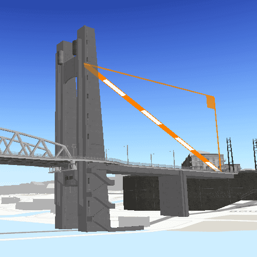
This sample demonstrates measuring 3D distances between two points in a scene.
The distance measurement analysis allows you to add the same measuring experience found in ArcGIS Pro, City Engine, and the ArcGIS API for JavaScript to your app. You can set the unit system of measurement (metric or imperial) and have the units automatically switch to one appropriate for the current scale. The rendering is handled internally so they do not interfere with other analyses like viewsheds.
How to use the sample
Choose a unit system for the measurement in the UI dropdown. Click any location in the scene to set the starting measuring point. Press, hold, and drag to a location to update the end location.
How it works
To measure distances with the LocationDistanceMeasurement analysis:
- Create an
AnalysisOverlayand add it to your scene view's analysis overlay collection. - Create a
LocationDistanceMeasurement, specifying thestartLocationandendLocation. To start with, these locations can be the same. Add the analysis to the analysis overlay. The measuring line will be drawn between the two points. - The
directDistanceChanged,verticalDistanceChanged, andhorizontalDistanceChangedsignals will emit when the distances change, giving access to the new values for thedirectDistance,horizontalDistance, andverticalDistance. The distance objects contain both the scalar value and unit of measurement.
Relevant API
- AnalysisOverlay
- LocationDistanceMeasurement
Additional information
The LocationDistanceMeasurement analysis only performs planar distance calculations. This may not be appropriate for large distances where the Earth's curvature needs to be taken into account.
Tags
3D, Analysis
Sample Code
// [WriteFile Name=DistanceMeasurementAnalysis, Category=Analysis]
// [Legal]
// Copyright 2018 Esri.
// Licensed under the Apache License, Version 2.0 (the "License");
// you may not use this file except in compliance with the License.
// You may obtain a copy of the License at
// http://www.apache.org/licenses/LICENSE-2.0
// Unless required by applicable law or agreed to in writing, software
// distributed under the License is distributed on an "AS IS" BASIS,
// WITHOUT WARRANTIES OR CONDITIONS OF ANY KIND, either express or implied.
// See the License for the specific language governing permissions and
// limitations under the License.
// [Legal]
import QtQuick
import QtQuick.Controls
import Esri.ArcGISRuntime
import Esri.ArcGISExtras
Rectangle {
id: rootRectangle
clip: true
width: 800
height: 600
property bool isNavigating: false
SceneView {
id: sceneView
anchors.fill: parent
Component.onCompleted: {
// Set the focus on SceneView to initially enable keyboard navigation
forceActiveFocus();
}
property bool isPressAndHeld: false
// Declare a Scene
Scene {
id: scene
// Set the basemap
Basemap {
initStyle: Enums.BasemapStyleArcGISTopographic
}
// Add a Scene Layer
ArcGISSceneLayer {
url: "https://tiles.arcgis.com/tiles/P3ePLMYs2RVChkJx/arcgis/rest/services/Buildings_Brest/SceneServer/layers/0"
altitudeOffset: 1
}
// Set the Surface
Surface {
ArcGISTiledElevationSource {
url: "https://elevation3d.arcgis.com/arcgis/rest/services/WorldElevation3D/Terrain3D/ImageServer"
}
}
// set initial viewpoint
ViewpointCenter {
center: locationDistanceMeasurement.startLocation
targetScale: 200
Camera {
location: locationDistanceMeasurement.startLocation
distance: 400
pitch: 45
heading: 0
roll: 0
}
}
}
// Declare an AnalysisOverlay
AnalysisOverlay {
id: analysisOverlay
// Declare a Location Distance Measurement
LocationDistanceMeasurement {
id: locationDistanceMeasurement
property string unitLabel: unitSystem === Enums.UnitSystemMetric ? "m" : "ft"
// set unit system
unitSystem: Enums.UnitSystemMetric
// set the start point
startLocation: Point {
x: -4.494677
y: 48.384472
z: 24.772694
spatialReference: SpatialReference { wkid: 4326 }
}
// set the end point
endLocation: Point {
x: -4.495646
y: 48.384377
z: 58.501115
spatialReference: SpatialReference { wkid: 4326 }
}
// connect to distance change signals
onDirectDistanceChanged: directDistanceText.text = directDistance.value.toFixed(2) + " %1".arg(directDistance.unit.abbreviation)
onHorizontalDistanceChanged: horizontalDistanceText.text = horizontalDistance.value.toFixed(2) + " %1".arg(horizontalDistance.unit.abbreviation)
onVerticalDistanceChanged: verticalDistanceText.text = verticalDistance.value.toFixed(2) + " %1".arg(verticalDistance.unit.abbreviation)
}
}
// handle mouse signals to update the analysis
// When the mouse is pressed and held, start updating the distance analysis end point
onMousePressedAndHeld: mouse => {
isPressAndHeld = true;
sceneView.screenToLocation(mouse.x, mouse.y);
}
// When the mouse is released...
onMouseReleased: mouse => {
// Check if the mouse was released from a pan gesture
if (isNavigating) {
isNavigating = false;
return;
}
// Ignore if Right click
if (mouse.button === Qt.RightButton)
return;
// If pressing and holding, do nothing
if (isPressAndHeld)
isPressAndHeld = false;
// Else get the location from the screen coordinates
else
sceneView.screenToLocation(mouse.x, mouse.y);
}
// Set a flag when mousePressed signal emits
onMousePressed: {
isNavigating = false;
}
// Update the distance analysis when the mouse moves if it is a press and hold movement
onMousePositionChanged: mouse => {
if (isPressAndHeld)
sceneView.screenToLocation(mouse.x, mouse.y);
}
// When screenToLocation completes...
onScreenToLocationCompleted: location => {
if (isPressAndHeld)
locationDistanceMeasurement.endLocation = location;
else
locationDistanceMeasurement.startLocation = location;
}
// Set a flag when viewpointChanged signal emits
onViewpointChanged: {
isNavigating = true;
}
}
Rectangle {
anchors {
fill: resultsColumn
margins: -5
}
color: "black"
opacity: 0.5
radius: 5
}
Column {
id: resultsColumn
anchors {
left: parent.left
top: parent.top
margins: 10
}
spacing: 5
Row {
spacing: 5
Text {
text: "Direct Distance:"
color: "white"
}
Text {
id: directDistanceText
color: "white"
}
}
Row {
spacing: 5
Text {
text: "Vertical Distance:"
color: "white"
}
Text {
id: verticalDistanceText
color: "white"
}
}
Row {
spacing: 5
Text {
text: "Horizontal Distance:"
color: "white"
}
Text {
id: horizontalDistanceText
color: "white"
}
}
Row {
spacing: 5
Text {
text: "Unit System:"
color: "white"
}
ComboBox {
id: comboBox
model: ["Metric", "Imperial"]
onCurrentTextChanged: {
if (currentText === "Metric")
locationDistanceMeasurement.unitSystem = Enums.UnitSystemMetric;
else
locationDistanceMeasurement.unitSystem = Enums.UnitSystemImperial;
}
}
}
}
}