Convert features into graphics to show them with mil2525d symbols.
Use case
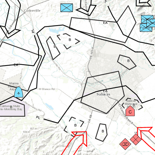
A dictionary renderer uses a style file along with a rule engine to display advanced symbology. This is useful for displaying features using precise military symbology.
How to use the sample
Pan and zoom around the map. Observe the displayed military symbology on the map.
How it works
- Create a
Geodatabasewith a given path. - Wait for geodatabase to completely load by connecting to the
loadStatusChangedsignal and checking theloadStatus. - Cycle through each
GeodatabaseFeatureTablefrom the geodatabase usingGeodatabase.geodatabaseFeatureTables(). - Create a
FeatureLayerfrom each table within the geodatabase. - Wait for each layer to load by connecting to the layer's
loadStatusChangedsignal and checking theloadStatus. - After the last layer has loaded, then create a new
Envelopefrom a union of the extents of all layers.- Set the envelope to be the
Viewpointof the map view usingMapView.setViewpoint(new Viewpoint(Envelope)).
- Set the envelope to be the
- Add the feature layer to map using
Map.operationalLayers.append(FeatureLayer). - Create
DictionaryRendererand attach to the feature layer by settingFeatureLayer.renderer.
Relevant API
- DictionaryRenderer
- DictionarySymbolStyle
- Geodatabase
Offline Data
To set up the sample's offline data, see the Use offline data in the samples section of the Qt Samples repository overview.
| Link | Local Location |
|---|---|
| Mil2525d Stylx File | <userhome>/ArcGIS/Runtime/Data/styles/arcade_style/mil2525d.stylx |
| Military Overlay geodatabase | <userhome>/ArcGIS/Runtime/Data/geodatabase/militaryoverlay.geodatabase |
Tags
military, symbol
Sample Code
FeatureLayer_DictionaryRenderer.qml
// [WriteFile Name=FeatureLayer_DictionaryRenderer, Category=Features]
// [Legal]
// Copyright 2016 Esri.
// Licensed under the Apache License, Version 2.0 (the "License");
// you may not use this file except in compliance with the License.
// You may obtain a copy of the License at
// http://www.apache.org/licenses/LICENSE-2.0
// Unless required by applicable law or agreed to in writing, software
// distributed under the License is distributed on an "AS IS" BASIS,
// WITHOUT WARRANTIES OR CONDITIONS OF ANY KIND, either express or implied.
// See the License for the specific language governing permissions and
// limitations under the License.
// [Legal]
import QtQuick
import QtQuick.Controls
import Esri.ArcGISRuntime
import Esri.ArcGISExtras
Rectangle {
width: 800
height: 600
readonly property url dataPath: {
Qt.platform.os === "ios" ?
System.writableLocationUrl(System.StandardPathsDocumentsLocation) + "/ArcGIS/Runtime/Data" :
System.writableLocationUrl(System.StandardPathsHomeLocation) + "/ArcGIS/Runtime/Data"
}
// Create MapView that contains a Map with the Topographic Basemap
MapView {
id: mapView
anchors {
fill: parent
}
Component.onCompleted: {
// Set the focus on MapView to initially enable keyboard navigation
forceActiveFocus();
}
Map {
id: map
Basemap {
initStyle: Enums.BasemapStyleArcGISTopographic
}
}
}
ProgressBar {
id: progressBar_loading
anchors {
horizontalCenter: parent.horizontalCenter
bottom: parent.bottom
margins: 5
}
indeterminate: true
}
Geodatabase {
property var gdbLayers: []
id: geodatabase_militaryOverlay
path: dataPath + "/geodatabase/militaryoverlay.geodatabase"
onLoadStatusChanged: {
if (Enums.LoadStatusLoaded === geodatabase_militaryOverlay.loadStatus) {
const tables = geodatabase_militaryOverlay.geodatabaseFeatureTables;
// Create a layer for each table
for (let i = tables.length - 1; i >= 0; i--) {
//! [Apply Dictionary Renderer Feature Layer QML]
// Create a layer and set the feature table
const layer = ArcGISRuntimeEnvironment.createObject("FeatureLayer");
layer.featureTable = tables[i];
// Create a dictionary renderer and apply to the layer
const renderer = ArcGISRuntimeEnvironment.createObject("DictionaryRenderer",{
dictionarySymbolStyle:
//! [Create Dictionary Symbol Style QML]
Factory.DictionarySymbolStyle.createFromFile(dataPath + "/styles/arcade_style/mil2525d.stylx")
//! [Create Dictionary Symbol Style QML]
});
layer.renderer = renderer;
//! [Apply Dictionary Renderer Feature Layer QML]
/**
* If the field names in your data don't match the contents of DictionarySymbolStyle::symbologyFieldNames(),
* you must set DictionaryRenderer::symbologyFieldOverrides to a map of key-value pairs like this:
* {
* "dictionaryFieldName1": "myFieldName1",
* "dictionaryFieldName2": "myFieldName2"
* }
* The following commented-out code demonstrates one way to do it, in a scenario where the dictionary
* expects the field name "identity" but the database table contains the field "affiliation" instead.
*/
/**
let fieldOverrides = {
identity: "affiliation"
};
renderer.symbologyFieldOverrides = fieldOverrides;
*/
gdbLayers.push(layer);
// Connect the layer's loadStatusChanged signal
layer.loadStatusChanged.connect(()=> {
// See if all the layers have loaded.
for (let j = 0; j < gdbLayers.length; j++) {
if (Enums.LoadStatusLoaded !== gdbLayers[j].loadStatus) {
return;
}
}
/**
* If we get here, all the layers loaded. Union the extents and set
* the viewpoint.
*/
let bbox = gdbLayers[0].fullExtent;
for (let j = 1; j < gdbLayers.length; j++) {
bbox = GeometryEngine.unionOf(bbox, gdbLayers[j].fullExtent);
}
mapView.setViewpointGeometry(bbox);
progressBar_loading.visible = false;
});
// Add the layer to the map
map.operationalLayers.append(layer);
}
}
}
}
}