▾
November 2026
Editing and selection enhancements
Support for dynamic choice form inputs
This release adds support for dynamic choice inputs in a feature layer’s form template used within Editor. A DynamicChoiceInput lets users select a field value from a list of choices generated by an Arcade expression, rather than a fixed list. Use a dynamic choice input when the available options depend on the feature being edited, values entered in other fields, or data queried from another layer or table. This input type is supported in both single and batch edit modes.
Selection map components
The new Selection Toolbar and Selection List components provide a coordinated workflow for managing feature selections. They share a view’s selectionManager by default and also support custom selection managers.
The Selection Toolbar provides tools for selecting features and graphics on a Map or Scene. You can add features to an existing selection, replace the current selection, remove features from a selection, or clear the selection.
The following video demonstrates how a selection initiated by the Selection Toolbar on the map updates selected rows in the Feature Table. The Feature Table has its syncViewSelection property enabled, allowing the table and Selection Toolbar to modify the same selection.
The Selection List displays selected features in a hierarchical list organized by group layer, layer, and feature. It supports browsing, filtering, expanding and collapsing items, zooming to selected features, and removing individual features or groups of features from the selection.
2D Label Callouts and Formatting Tags
We added support for two highly requested labeling features: callouts and formatting tags.
Callout labels can be used to highlight and point to features in the map without obscuring map data or details. Callout labels are implemented through the CIMTextSymbol and its associated callout properties.

Text formatting tags can be used to create mixed-format labels by applying different formatting to portions of a label. Use the tags to apply different colors, fonts, or emphasis to individual parts of the label. They can be used almost anywhere labels appear on the map and are supported for 2D FeatureLayers and MapImageLayers that support Arcade.

Improved AI components and better accuracy and reliability for agents
The latest version of AI components significantly increased the accuracy and reliability of data exploration and agent responses, improved interoperability between custom agents and agents provided by the JS Maps SDK, and introduced a new agent type. Check out the full list of improvements below.
More accuracy in agent responses
Updated models. The underlying large-language models used by AI components have been upgraded to the GPT-6 family of models. These models are more capable, accurate, and reliable, resulting in improved agent responses and better overall performance. See the ChatModelTier for more details. Keep in mind that model updates can introduce unpredictable behavior in agents. While agents provided by the JS Maps SDK have improved, you should still review and test any custom agents you wrote upon upgrading, as model updates may necessitate changes to your prompts or agent logic.
Agent updates. The Navigation, Data Exploration, and Help agents were refactored to skill agents. Combined with the GPT-6 family of models, these changes result in more accurate, better-qualified, reliable, and transparent answers.
Shared resources
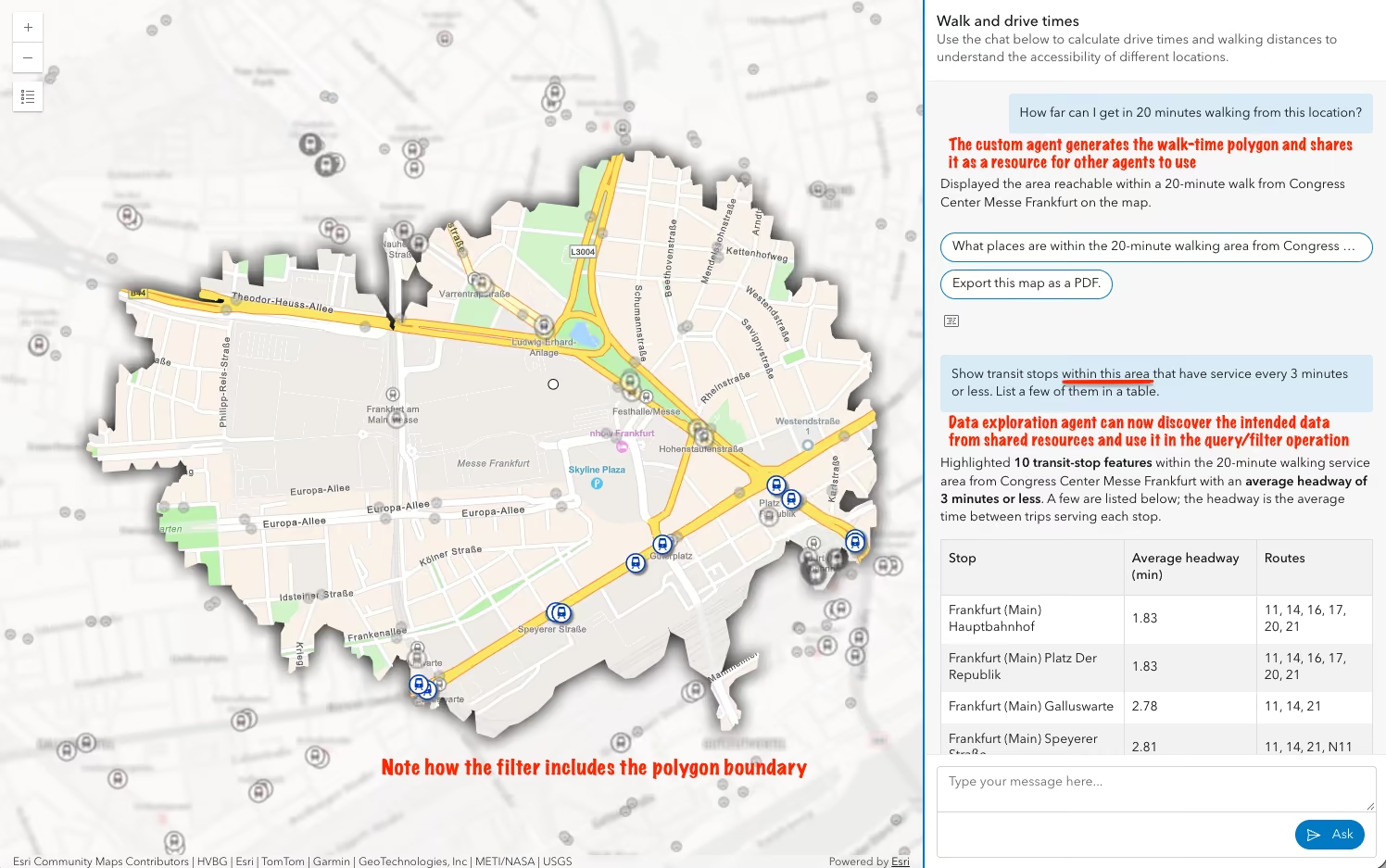
Agents and their tools can now share resources to a common workspace so tools in other agents can use them as input in their own workflows. For example, a custom agent may generate a polygon, add it as a shared resource, so it can later be used by the Data Exploration agent in a spatial query or filter.
Skill agents
The new SkillAgent class lets you build custom agents with reusable skills and tools that load on demand. Skill agents allow you to define agent logic using natural language in markdown files, making it easier to create and maintain complex agent behaviors without having to maintain complex graph code.
While you can write custom tools for skill agents, you can also add tools already used by JS Maps SDK agents to you skills. All you have to do is list them by name in your skill file to make them available for use within your agent’s workflow. See the documentation for this list of tools for more details.
Enterprise support
At ArcGIS Enterprise 12.2, you will be able to build agentic web applications for exploring data in web maps from your Enterprise portal. The organization must enable the use of AI agents and provide credentials for an ArcGIS Online organization where the AI models are provided.
Other improvements
Human-in-the-loop improvements. Single- and multiple-selection prompts can now include an Other option for entering a custom response alongside predefined choices. Approval middleware also handles multiple approval steps more reliably when an agent resumes.
More control over agent routing. You may want to have full control of agent orchestration and routing. To do this, create a custom agent that acts as a parent agent to one or more subagents, and set the ID of your parent agent to alwaysUseAgentId to bypass the default orchestration logic.
Simplified API organization. Agent utilities now support class constructors with both npm and CDN imports. Prompt, signal, and state helpers have dedicated modules under the orchestrator API, making related APIs easier to find.
Component improvements. We made several UX and developer experience enhancements to the arcgis-assistant component, including improving the developer experience for progressively disclosing components as part of agent responses.

arcgis-directions component as part of its response to the user. Components like this can be progressively disclosed to complement a custom agent’s response.
Viewshed and Shadow Cast support for Gaussian Splat layers
Gaussian Splat layers now support Viewshed and Shadow Cast analysis, expanding the range of 3D analysis workflows available for Gaussian Splat layers. Analysis results reflect the underlying Gaussian Splat representation. As a result, surface noise or reconstruction artifacts that are subtle in the visualization may become more apparent and analysis boundaries may appear less sharply defined than in comparable results generated from integrated mesh layers.
Time Bar component
The new Time Bar component replaces the TimeSlider widget and component, providing a highly configurable interface for exploring and animating time-aware data. You can choose any combination of playback buttons, a time extent label, and a settings button, with or without a Time Bar Slider. This supports layouts ranging from a single play button to a full time navigation component. The Time Bar Slider adds interactive date or range selection with customizable date labels, ticks, and popover content.

GeospatialPDFLayer
The new GeospatialPDFLayer displays georeferenced PDFs as raster imagery, using spatial metadata embedded in each document to position its content on the map. Add a PDF as a basemap, overlay it on another basemap, or display it as standalone map content. Client-side reprojection supports PDFs created in different spatial references without requiring preprocessing. This makes it easier to bring scanned historic maps, incident and emergency response maps, operational documents, and other established map products into web applications. Use these documents alongside live GIS data to compare historical and current conditions, add operational context, and support field and emergency response workflows.
SketchLayer
The new SketchLayer is similar to a GraphicsLayer, but adds support for saving sketch graphics in a web map. Create graphics with the Sketch component or in code, then add them to the layer’s graphics collection.
- Save and share: Save the WebMap to persist sketches. Users can share the map and continue working with the sketches in Map Viewer.
- One graphics collection: Add, remove, and iterate over point, polyline, polygon, multipoint, and text graphics in a single collection, rather than working with geometry-specific sublayers.
- MapNotesLayer replacement: SketchLayer replaces the deprecated MapNotesLayer and handles the geometry-specific feature collections required by the web map format when saving.
- Load existing sketches: To load existing web map sketches as SketchLayer instead of MapNotesLayer, enable the
sketch-layer-enabledflag before loading SDK modules, as described in the SketchLayer documentation.
ParquetLayer: expanded data support, charts, and refresh
Updates to ParquetLayer include:
- Expanded data support: Supports
date-onlyandtime-onlyfields, as well as M- and Z-aware geometries. ThehasMandhasZproperties indicate whether feature geometries contain measure (M) and elevation (Z) values. - Charts: Use the
chartsproperty to visualize data directly in a ParquetLayer with various chart types. - Data refresh: Configure the layer to refresh on a recurring interval or on demand to display the latest data.
- Portal items: Save a ParquetLayer as a portal item to share and reuse it across applications, or update an existing item with the latest layer configuration and data.
AI-assisted development
New guide for AI-assisted development
The new AI-assisted development guide explains how to use AI coding assistants when building applications with the ArcGIS Maps SDK for JavaScript. It covers how to provide assistants with relevant SDK context, use documentation and code examples to guide code generation, and review AI-generated code for accuracy.
Markdown for agents
Markdown versions of reference, guide, tutorial, release notes, and sample code pages are now available to copy or view. These versions are cleaner, smaller, and more structured, making the content easier for people and AI to process, reducing token usage, and helping agents work more effectively.
Check each page for the “Copy as Markdown” and “View Markdown” dropdown. When you view the page as markdown, the trailing / in the URL is replaced with .md.
Symbology updates
Halos on CIMPointSymbol
CIMPointSymbol now supports halos, which are rendered around point symbols to emphasize their presence or to visually separate them from competing background information.
Use the haloSize and haloSymbol properties to define a halo. The haloSize sets the size of the halo, while haloSymbol is a CIMPolygonSymbol that defines its appearance.

CIMSymbol Circular Sector geometric effect
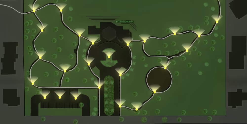
CIMSymbol now supports a new geometric effect called CIMGeometricEffectCircularSector.
This effect allows for the creation of dynamic sectors from point symbols, which can be used to represent directional data or to create pie chart-like visualizations on the map.
The Circular Sector effect can be customized with properties such as startAngle, endAngle, and radius, and can be used with primitive overrides to create dynamic visualizations based on feature attributes.
CIM animations along a line
CIM animations along a line are no longer in beta. This release improves support for animating a single marker along a line, such as an airplane following a flight path. It also includes fixes for rendering issues at tile boundaries and improvements to continuous animation behavior for smoother, more consistent movement along lines. CIM animations are only supported in 2D maps.
World sizing and new patterns for 3D lines
LineSymbol3D now supports world-sized line widths. When worldSized is enabled, line sizes are interpreted in meters instead of screen units, allowing line symbols to maintain consistent real-world dimensions. PathSymbol3DLayer dimensions are inherently world-sized and this property does not affect them.
A new LineTemplatePattern3D pattern type provides precise control over dashed line symbology. Define custom dash and gap sequences with a dashTemplate array to create road markings and other line patterns with exact spacing requirements.
Annotation and Dimension layers
Updates to AnnotationFeatureLayer and DimensionFeatureLayer include:
- Portal items: Save these layers as new portal items or update existing items to preserve and share layer changes across applications and sessions.
- Linear dimensions: DimensionFeatureLayer displays horizontal and vertical distances between points and honors the display units defined in dimension styles.
- Callouts and stacked text: AnnotationFeatureLayer supports callouts that visually connect annotation text to its associated feature, as well as stacked text that spans multiple lines. See 2D Label Callouts and Formatting Tags for more information about callouts.
- Feature Table: The Feature Table supports viewing Annotation and Dimension layers. Editing these layer types is not yet supported, but is planned for a future release.
Utility Network Trace Analysis enhancements
Trace Analysis component
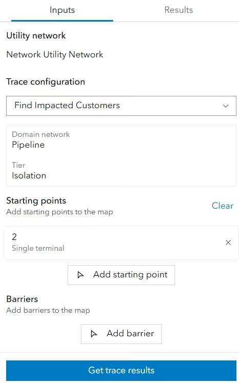
The Utility Network Trace Analysis component now supports custom feature actions and control over action bar visibility when selecting trace locations and viewing result features. Configure these behaviors with the actions and hideActionBar properties, and handle action execution with the arcgisTriggerAction event. You can also configure the size of aggregated geometry result graphics with aggregatedGeometryResultsSize.
New subcomponents
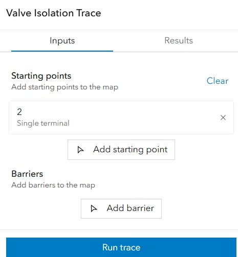
New Utility Network Trace Analysis subcomponents allow you to customize trace inputs and results. Use these components to tailor the trace workflow and result presentation to your application:
- Utility Network Picker selects a utility network from the map.
- Configuration Picker selects a named trace configuration.
- Inputs configures trace inputs, including starting points and barriers.
- Locations manages trace locations.
- Results displays the results of one trace.
- Results Pane organizes trace results.
- Elements Result Item displays the network elements returned by a trace.
- Functions Result Item displays function results returned by a trace.
- Aggregated Geometry Result Item displays aggregated geometry returned by a trace as graphics in the view.
| Custom Trace component built with subcomponents | Utility Network Trace Analysis component (default) |
|---|---|
 |  |
Google Photorealistic 3D basemap
Load in self-hosted applications
The Google Photorealistic 3D basemap can now be loaded in self-hosted JavaScript Maps SDK applications. This basemap provides a 3D mesh textured with high-resolution imagery in many cities and populated regions across the globe. Variants with and without labels are available to load from the Basemap Gallery or by referencing their PortalItem IDs.

Drape raster layers
Draping raster layers on the Google Photorealistic 3D basemap is now supported, enabling environmental, analytical and operational raster overlays to be visualized within realistic 3D environments. This extends existing draping workflows beyond traditional terrain surfaces. Supported layer types include MapImageLayer, ImageryLayer, WMSLayer, and BaseDynamicLayer. Tiled variants are not currently supported. See the screenshot showing a nitrogen dioxide (NO₂) emissions map in Zurich draped over the Google Photorealistic 3D basemap using the Kanton Zürich WMS Immissionen Luftqualität dataset.

Accessibility Improvements
Explore maps and charts data by keyboard
As part of our ongoing work to make mapping experiences more accessible, this release introduces a keyboard-accessible focus region for Map, Scene, and Link Chart components. It gives users another way to explore data and open feature popups without a mouse.
The new focus region provides keyboard access to data within an adjustable spatial area, allowing users to explore different parts of the view and open popups for features with a keystroke. The focus region makes map content easier to discover and provides consistent keyboard interaction across the Map, Scene, and Link Chart components.
The focus region is built into the Map, Scene, and Link Chart components and can be toggled using a keyboard shortcut while the view component is in focus. By default, the keyboard shortcut is enabled only when a popup component is slotted into the view component or popupComponentEnabled is true, and the popupDisabled property is false. The focus region styling can be customized through the new view component CSS variables.
Below is a summary of the available actions and their corresponding keyboard shortcuts or properties:
| Action | Keyboard Shortcut / Property |
|---|---|
| Enable or disable focus region | Use the Shift + Alt/Opt + O keyboard shortcut while the view component is in focus, or set the focusRegionVisible property to true or false. |
| Resize focus region | Use the Shift + Alt/Opt + Up/Down arrow keys while the focus region is active. |
| Open the popup for features in the focus region | Press Enter or Spacebar while the focus region is active. |
Enable or disable the Shift + Alt/Opt + O keyboard shortcut | Set focusRegionShortcutEnabled to explicitly enable or disable the shortcut for custom selection handling. |
More precise keyboard navigation
Map and Scene components, along with MapView and SceneView, now support more precise keyboard panning. Hold Alt while pressing an arrow key to move in smaller increments, or hold Shift to move in larger increments. Press two arrow keys simultaneously to pan diagonally.
See the MapView navigation and SceneView navigation documentation for more information about keyboard navigation and shortcuts.
Improved ARIA support
Updated ARIA labels in the Popup, Features (Next), and Video Player components provide additional context and make interactive elements easier to identify, particularly for people who use assistive technologies.
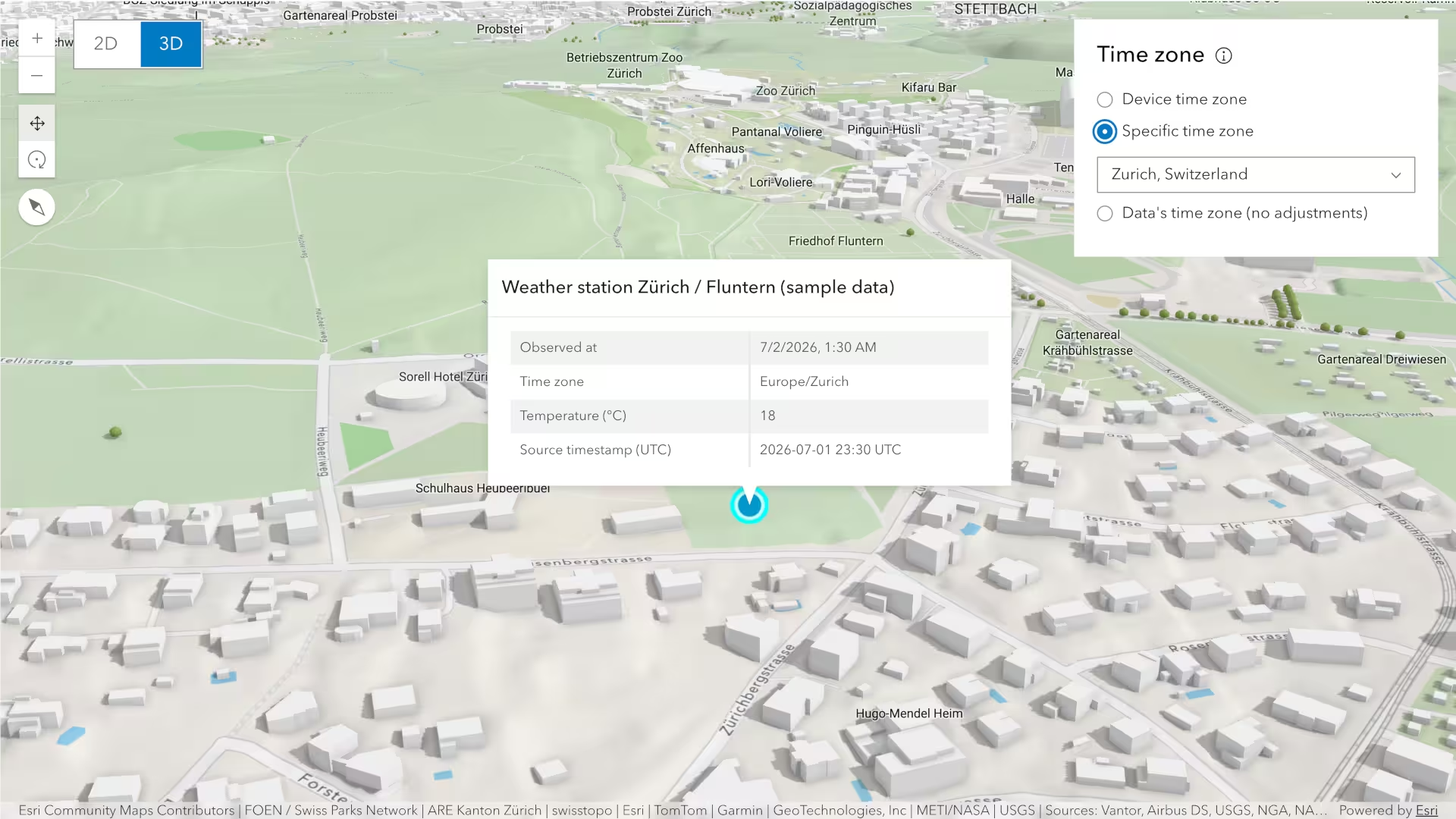
Time zone support in web scenes
Time zone support is now available in web scenes, making time zone handling consistent across 2D maps and 3D scenes. Configure the time zone using the timeZone property on the Scene component or on SceneView. The default value is system, which uses the time zone of the device or browser. Set the value to unknown to display dates and times using the time zone defined by each layer, or specify an IANA time zone.
Individual slides can also store and apply their own time zones, allowing the time zone to change as you navigate through a presentation.
Date and time values in Arcade expressions, labels, renderers, forms, and visual variables now use the selected time zone. The selected time zone is also reflected in components that display dates and times, including Bookmarks, Editor, Feature, Feature Form, Features, Feature Table, Legend, Popup, and Time Bar.
The Daylight and Shadow Cast components do not yet use the web scene’s time zone. They continue to use their respective
utcOffsetproperties for lighting and solar analysis.
View options for snapping, tooltips and units
The new options property configures snapping, tooltips, display units, and input units for supported components, analyses, and view models. It is available on the Map component and Scene component, as well as through MapView.options and SceneView.options. Use options.snapping and options.tooltips to configure interactions, options.displayUnits for displayed measurements, and options.inputUnits for numeric input.
See ViewOptions for the supported options and limitations.
Exploratory Analysis component
The new Exploratory Analysis component provides a container for measurement and analysis components, displaying one active tool at a time. Add supported analysis components as children to create a toolbar for switching between tools.
<arcgis-exploratory-analysis slot="top-right" show-heading> <arcgis-distance-measurement-2d></arcgis-distance-measurement-2d> <arcgis-area-measurement-2d></arcgis-area-measurement-2d> <arcgis-elevation-profile></arcgis-elevation-profile></arcgis-exploratory-analysis>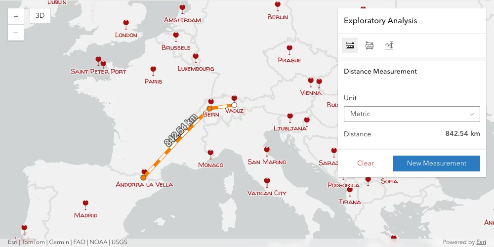
Highlight features with FeatureFilter
The highlight() method now accepts a FeatureFilter as a target in 2D MapView and the Map component. Use a FeatureFilter to highlight features that match attribute or spatial criteria, such as highlighting features within 2 miles of a moving pointer. Unlike graphics or objectIDs, which highlight the specified features, a FeatureFilter continues to highlight matching features as they become available while navigating the map.
// Highlight trees that intersect the buffer circleareaHighlightHandle = layerView.highlight( new FeatureFilter({ geometry: bufferGeometry, spatialRelationship: "intersects", }),);Simple math expressions in tooltips
Tooltips in sketching, editing, and visibility analyses now support simple math expressions,
such as +1.5 or -25. This enhancement makes it easier to adjust the X, Y, or Z positions of features, vertices, observers, and targets with greater precision.
Enhanced visibility analyses
This update improves the placement and editing experience for interactive visibility analyses. New tooltips and snapping capabilities provide greater control when positioning observers and targets. Tooltips now support elevation mode selection, making it easier to adjust the vertical position of points.
These enhancements apply to both viewshed and line of sight analyses as well as to the Line Of Sight component.
Additionally, you can now specify default elevation settings when calling the ViewshedAnalysisView.place() or LineOfSightAnalysisView.place() methods.
Screen area hit targets
You can now retrieve multiple features in a 3D scene by specifying an area on the screen instead of a single point. SceneView.hitTest() and the Scene component’s hitTest() method now accept a ScreenRect or ScreenPolygon as a hitTarget and return rendered features that intersect the specified area.
Support for ScreenPolygon hit targets also extends to 2D maps. The new excludeLabels option in 2D HitTestOptions controls whether labels are included in or excluded from hit results.
Attribution enhancements
Improved contrast
The contrast of attribution text has been enhanced to improve readability and accessibility across different map backgrounds. By default, a blur has been added and the background, opacity, and text colors have been adjusted for improved contrast in both light and dark modes.
| 5.1 | 5.2 |
|---|---|
 |  |
 |  |
Auto theming
A new attributionMode value, auto, has been added to the Map, Scene, and Link Chart components. Setting attributionMode to auto synchronizes the attribution theme with the rest of the page based on the Calcite theme. The light and dark modes remain available when you want to set the attribution to a different theme from the rest of the application.
Enhanced layer searching
The new LayerSearchSource.searchMode property helps users work more effectively with full-text-indexed layers. Previously, exactMatch could be true or false, where true meant an exact match and false meant a trailing-wildcard search. Now, searchMode can be "simple", "starts-with", "full-text-starts-with", or "full-text-simple". Configure these values in LayerSearchSource or in a web map’s portal settings. The legacy behavior remains unchanged.
The table below compares these values for a feature whose portname property is “Northern Indiana Maritime District”:
| exactMatch | searchMode | searchMode behavior |
|---|---|---|
| true | ”simple” | (portname = "Northern Indiana Maritime District") |
| false | ”starts-with” | (LOWER(portname) LIKE 'North%') |
| true | ”full-text-simple” | [{"onFields":["portname"],"searchTerm":"Northern Indiana Maritime District","searchType":"simple"}] |
| false | ”full-text-starts-with” | [{"onFields":["portname"],"searchTerm":"North","searchType":"prefix"}] |
We deprecated the LayerSearchSource.exactMatch property in favor of searchMode. If both exactMatch and searchMode are defined, searchMode takes precedence. If searchMode is not defined, the exactMatch property value will still infer the search behavior. See the Full-text indexes ArcGIS Pro documentation and the Add indexes to attribute fields ArcGIS Online documentation for more information. If the layer is not full-text indexed, the full-text-simple mode falls back to simple, and the full-text-starts-with mode falls back to starts-with.
Map Components
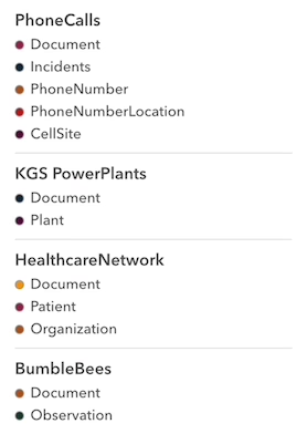
Legend design changes
The Legend component has been redesigned with a more compact layout that displays more items in a smaller footprint while preserving readability. Spacing has been refined across classic and ramp legend styles, including conditional spacing for single-symbol entries. The updated design also applies to the legend in Layer List (Next).
| 5.1 | 5.2 |
|---|---|
 |  |
New map components
The following map components were added in this release:
arcgis-basemap-layer-list-next: A native replacement for the wrappedarcgis-basemap-layer-listcomponent for managing basemap layer visibility.arcgis-catalog-layer-list-next: A native replacement for the wrappedarcgis-catalog-layer-listcomponent for managing catalog layer visibility.arcgis-table-list-next: A native replacement for the wrappedarcgis-table-listcomponent for managing tables.
Popup & Features (Next) actions slots
The Popup and Features (Next) components now include actions-start and actions-end slots. Use these slots to add custom Calcite actions or action groups and control their placement, order, styling, and grouping within the components.
Display attachments in a carousel
The Popup and Features (Next) components now support displaying attachments in a carousel layout, making it easier to browse multiple attachments within the component interface. Configure this behavior through AttachmentsContent using the new “carousel” displayType, which can be persisted to the web map or web scene.
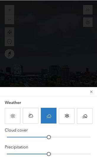
Expand component modal-disabled attribute
The modal-disabled attribute for the Expand component prevents the page-blocking modal from appearing in mobile view or drawer mode, keeping the map visible while the component is expanded. In 6.0, this behavior is planned to become the default.
| default | modal-disabled |
|---|---|
 |  |
Feature Table updates
Support for a view’s time extent
The new viewTimeEnabled property lets the Feature Table honor the timeExtent set on the view. Previously, the table did not account for the view’s time extent. When enabled, this property sets the table’s time extent to the intersection of the view’s and layer’s timeExtent values.
Declaratively target a specific layer or table
The Feature Table component now provides layerId and tableId properties for selecting a specific layer or standalone table in an item with multiple layers or tables. When configuring the component declaratively, set an appropriate layerId or tableId along with layerItemId.
<!-- item contains multiple layers and tables - use layerId to target a specific layer --><arcgis-feature-table layer-item-id="0777d381a2b249ed8c5243f7d0ca49f7" reference-element="my-map" layer-id="0"></arcgis-feature-table>Charts components
Reference element
Added support for the new referenceElement and mapLayerId properties.
Along with chartIndex, these properties allow users to declaratively load and display a pre-configured chart from the web map by referencing the appropriate map layer.
<arcgis-map id="my-map" item-id="f2481ef191924872be8897179f73d55c"></arcgis-map><!-- configure the chart to use a layer from the map by setting the mapLayerId property --><arcgis-chart map-layer-id="194f7ed3447-layer-50" reference-element="my-map" chart-index="0"></arcgis-chart>Radar chart
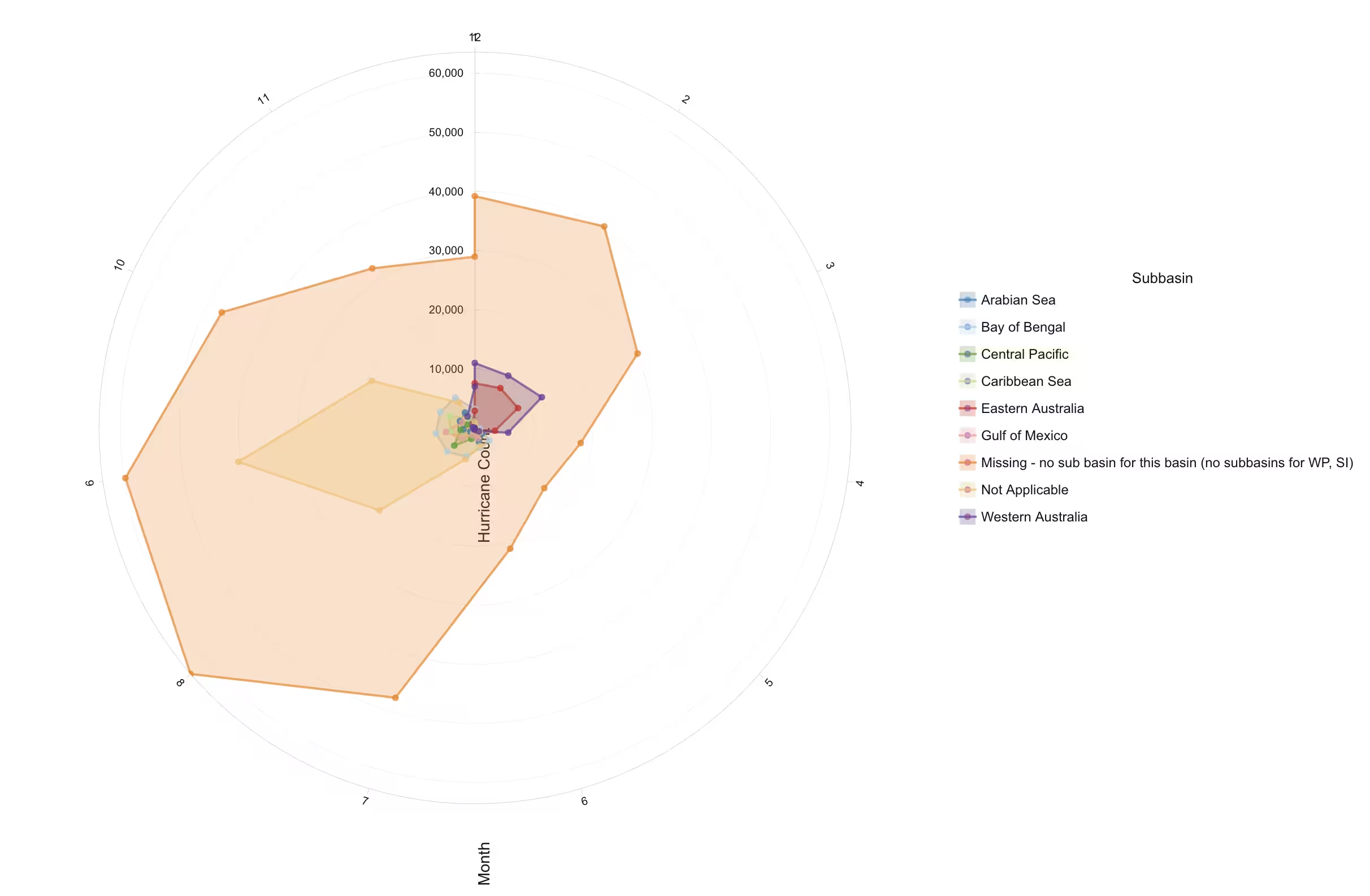
The new radar chart lets you visualize multiple variables across different categories in a radial layout, making multivariate data easier to compare and analyze.
The radar chart below visualizes hurricane counts across subbasins over different months. Each subbasin is represented with a different series and area colors.
Additional layer support
The supported layer property for charts now includes additional feature-like layers, whether you load an existing chart from a layer item or create a new chart with the charts model.
This includes ParquetLayer, GeoJSONLayer, CSVLayer and other feature-like layers.
Common Components
Value Picker
The arcgis-value-picker component replaces the arcgis-value-picker-legacy and its predecessor, the ValuePicker widget. It offers an intuitive API and finer-grained control over the user experience through subcomponents: the arcgis-value-picker- collection, combobox, label, and slider. Instead of relying on the component attribute, nest the appropriate subcomponents as shown in the example below:
<arcgis-map basemap="topo">  <arcgis-value-picker slot="bottom-left">    <arcgis-value-picker-slider></arcgis-value-picker-slider>  </arcgis-value-picker>
  <arcgis-value-picker slot="bottom-right">    <arcgis-value-picker-combobox></arcgis-value-picker-combobox>  </arcgis-value-picker>
  <arcgis-value-picker slot="top-right">    <arcgis-value-picker-label></arcgis-value-picker-label>  </arcgis-value-picker>
<arcgis-value-picker slot="top-left"> <arcgis-value-picker-collection></arcgis-value-picker-collection> </arcgis-value-picker></arcgis-map>Histogram Range Slider
The arcgis-slider-histogram-range replaces the HistogramRangeSlider widget and provides a more streamlined authorship experience than using separate Histogram and Slider components.
ViewModel updates and deprecations
As part of our transition from widgets to components, the existing widget ViewModel modules are being deprecated. Some will be replaced by new modules outside of the /widgets folder, while others will eventually be removed from the SDK. The following replacement modules have been introduced this release:
| Deprecated ViewModel | Replacement | Functionality |
|---|---|---|
| BasemapGalleryViewModel | BasemapGalleryModel | Provides logic for displaying and selecting a collection of basemaps. |
| FeatureViewModel | FeatureModel | Provides logic for resolving popup template content for a graphic. |
| FeaturesViewModel | FeaturesModel | Provides logic for managing a collection of graphics’ reactive state and behavior. |
| LayerListViewModel | LayerListModel | Provides logic for managing and customizing layer list items. |
| LegendViewModel | LegendModel | Manages the reactive content displayed by legends. |
The PortalBasemapsSource and LocalBasemapsSource modules have also been moved to a new location under the core/basemapGallery directory.
Deep sky background
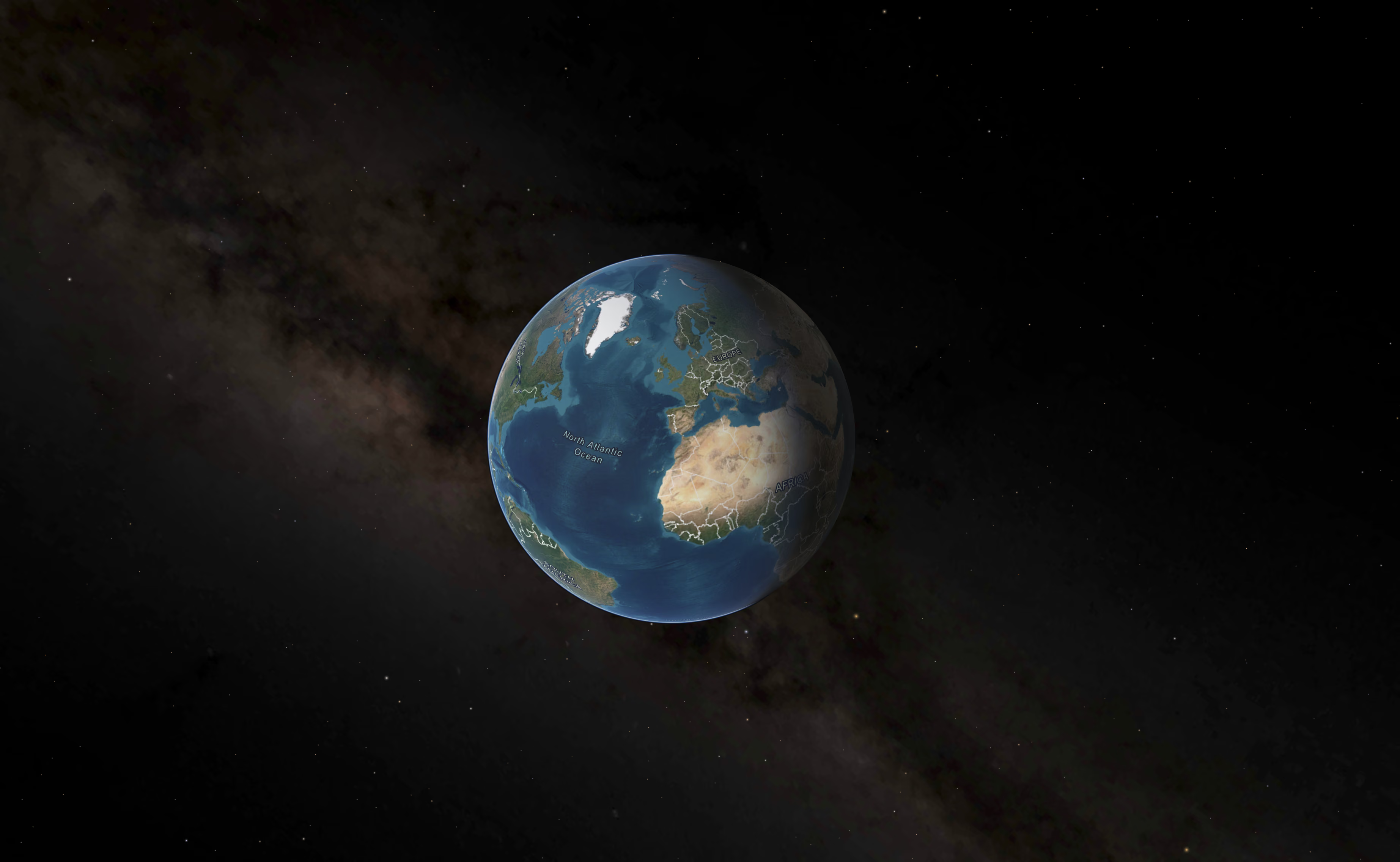
In 3D scenes, the deep sky background now includes a visualization of the Milky Way. This adds more detail to scenes with a night sky or to globe-scale views where the deep sky background is visible.
Light emitters and weather
Light-emitting objects now interact more realistically with weather in 3D scenes. During cloudy, rainy, snowy, and foggy conditions, emissive colors tint the atmosphere around them, while distant emitters gradually soften and fade.
Emissive materials also interact more naturally with focus areas and analysis tools.
BuildingSceneLayer reflects recent edits
BuildingSceneLayer now supports reflecting edits from its associated Feature layer before those changes are incorporated into the scene layer cache. Attribute edits are reflected in rendering, popups, and other attribute-driven workflows, ensuring that they use the latest available values. This behavior is consistent with the support already available for 3D object scene layers and helps applications stay synchronized with recent edits while scene layer caches are being updated.
Global Illumination
Global Illumination enhances lighting and depth perception in 3D scenes in the ArcGIS Maps SDK for JavaScript. It provides these two contributions to scene lighting:
- Ambient occlusion darkens areas where surrounding geometry blocks ambient light. It adds detail and definition to geometry and can improve depth perception, for example, by darkening streets between tall buildings.
- Emissive lighting brightens areas around emissive materials. This new effect is especially useful in urban nighttime scenes, where streetlights, illuminated buildings, or glowing symbols can cast light nearby. The illumination depends on the emitters’ strength and color, as well as their distance from the surfaces they illuminate.
These lighting improvements help users better understand complex 3D environments and spatial relationships, and enhance realism while requiring no additional scene authoring, making web applications both more informative and visually engaging.
Layer enhancements
Overriding timeInfo for feature-based layers
The timeInfo property makes a layer time-aware, enabling temporal filtering and animation to reveal patterns over time in data such as earthquake activity, wildfire progression, or building permit approvals.
Starting with version 5.2, you can set or override timeInfo in the constructor or at runtime for the following feature-based layers:
AnnotationFeatureLayer, CSVLayer,
CatalogLayer, DimensionFeatureLayer,
FeatureLayer, GeoJSONLayer,
OGCFeatureLayer, OrientedImageryLayer,
SceneLayer, StreamLayer, and SubtypeGroupLayer.
Overriding timeInfo lets you add or customize time behavior without modifying the source service. This is particularly useful for services you do not own or cannot reconfigure. You can switch time fields at runtime to explore different temporal perspectives using the same layer and source data. Each application can use the time settings relevant to its workflow while sharing the same source data. Time configurations can also be saved in a web map or supported layer portal item to share and reuse them across applications.
Dynamic workspace layer sources
The new DynamicWorkspaceLayer source type lets you use pre-authored layer files (.lyrx) from registered workspaces with map services.
It allows a layer to use an advanced renderer and cartographically enriched symbols, including symbols that are not supported by the map service’s REST API specifications.
It can be used as a source for sublayers in a MapImageLayer, or as a dynamic data source for FeatureLayer.
Dynamic workspace layer sources cannot currently be saved to web maps, web scenes, link charts, or portal items.
VectorTileLayer support for GeoJSON source
A VectorTileLayer can now consume a style that references a GeoJSON source. GeoJSON sources must satisfy the requirements described in the GeoJSONLayer overview.
Distance-aware queries
Feature layers that consume a feature service now support sorting and ranking features by distance from a specified location. This is useful for proximity-based workflows, such as identifying hotels within 10 miles of an airport and ordering them by their distance from a convention center. Use the Query.outDistance property to return distance values in the results and optionally sort features by ascending or descending distance.
Height model info no longer required for 3D layers
The JavaScript Maps SDK can now infer information about the vertical coordinate system directly from a layer’s spatial reference. 3D layers no longer need to specify a HeightModelInfo. In a future update, height model info is expected to be deprecated.
Refined rendering of occluded 3D labels and icons
The rendering of occluded labels and icons has been refined to improve readability and depth perception. Labels now retain full contrast when the view is idle, while icons in visible mode provide clearer visual cues about their relationship to surrounding 3D content.
Geometry operator export and type renames
Geometry operators now include new self-describing exports that improve autocomplete, readability, and discoverability. For example, bufferOperator.execute() is now also available as bufferExecute(), and generic option types have been renamed to operator-specific types.
The previous export and option type names are deprecated as of 5.2 and will be removed in 6.0. Updated names are available alongside the deprecated names to support migration.
The geometry-operator-renames codemod is available to help migrate existing applications to the updated geometry operator export and option type names. Refer to the codemod documentation for usage details.
import { bufferExecute } from "@arcgis/core/geometry/operators/bufferOperator";import { withinExecute } from "@arcgis/core/geometry/operators/withinOperator";
const bufferedRoad = bufferExecute(roadPolyline, 250, { unit: "meters" });const isInside = withinExecute(pointOfInterest, bufferedRoad);
Oriented Imagery improvements
- When exploring 3D images in the Oriented Imagery Viewer, you can now add a frustum filter, enabling image searches to use camera frustums instead of 2D footprint polygons when searching for images.
- You can now use depth images in OrientedImageryLayers, providing more accurate depth-aware calculations and visualization experiences.
- The Oriented Imagery Viewer now renders 360-degree images with improved brightness.
Documentation improvements
New and updated samples
New and updated 5.2 samples highlight current features and best practices, including an Arcade Editor sample for testing expressions, calculating hydrant flow rates, and displaying results in a Feature Table.
Enhanced guide demos
The guide pages are beginning to use a more robust demo structure that offers users exciting ways to engage with the content. This includes the ability to open demos in the Sandbox, navigate to a demo’s item property page, unpack view data, and more. Many demos are placed side-by-side to better exhibit the two implementation patterns active in the SDK: web maps or scenes built with Map or Scene Viewer and code-defined maps built entirely with JavaScript. Several introduction pages also use a new navigation block with interactive chips that link to subtopic pages. Explore the visualization and charts guides to see these new demo capabilities in action.
Changes to beta features
This section highlights updates to beta features that may affect existing implementations and require code changes.
Map component beta changes
- The
promisesproperty andfetchFeatures()method have been removed from the Popup component. Use thefetchPopupFeatures()method on the Map, Scene, or Link Chart component instead.
AI components beta changes
For custom agents built with AI components 5.1, review these 5.2 migration changes. For new features in 5.2, see the AI components and agents section.
Update the following imports to use their new module paths in 5.2.
| APIs | 5.1 module | 5.2 module |
|---|---|---|
sendUXSuggestion, UXSuggestion | utils/index.js | orchestrator/signals.js |
sendTraceMessage, TraceEventData | utils/index.js | orchestrator/signals.js |
invokeTextPrompt, invokeStructuredPrompt, invokeToolPrompt, ArcgisPromptOptions, ArcgisStructuredPromptOptions, ArcgisToolPromptOptions | utils/index.js | orchestrator/models/prompts.js |
getEmbeddings | utils/index.js | orchestrator/embeddings/getEmbeddings.js |
ChatHistory, UiInterrupt, AgentRegistration, AgentStatus, PriorStep, AgentExecutionContext, CustomConfigurableType | utils/index.js | orchestrator/types.js |
SharedState, SharedStatePatch | utils/index.js | orchestrator/state/types.js |
Construction
In 5.2, use class constructors with either CDN or npm imports. The factory functions for these agent, tool, and workflow classes have been removed. Replace a factory with the corresponding class constructor:
In 5.1:
import { createFunctionAgent } from "@arcgis/ai-components/agent-utils/index.js";
const agent = await createFunctionAgent({  name: "My agent",  execute: () => "Done",});
In 5.2:
import { FunctionAgent } from "@arcgis/ai-components/agent-utils/FunctionAgent.js";
const agent = new FunctionAgent({  name: "My agent",  execute: () => "Done",});
For the other factory replacements, import agent classes from
agent-utils/<ClassName>.js, tool classes from
agent-utils/tools/<ClassName>.js, and workflow classes from
agent-utils/workflows/<ClassName>.js.
The factories returned promises; class constructors return instances directly, so update any promise chains that depend on the factory result.
Schemas
If you build Zod schemas directly, no changes are needed for this migration.
If you used createSchema(), update its import location and schema definition
format as shown below.
In 5.1:
import { createSchema } from "@arcgis/ai-components/agent-utils/index.js";
const schema = await createSchema({  name: { type: "string", required: true },  tags: { type: "array", itemType: "string" },  // Nested object: fields are defined inside "fields".  options: {    type: "object",    fields: {      enabled: { type: "boolean", required: true },    },  },});
In 5.2:
import { createSchema } from "@arcgis/ai-components/agent-utils/createSchema.js";
const schema = await createSchema({  type: "object",  properties: {    name: { type: "string" },    tags: { type: "array", items: { type: "string" } },    // Nested object: use "properties" and a local "required" array.    options: {      type: "object",      properties: {        enabled: { type: "boolean" },      },      required: ["enabled"],    },  },  required: ["name"],});
Middleware
Agent middleware configuration has changed. If you use custom agent middleware, see the API documentation for updated configuration and usage. Tool middleware is unchanged.
Map components changes
Additions
- components/
- arcgis-area-measurement-2d/
- arcgis-area-measurement-2d
- hideResetUnitsButton - property
- interactionDisabled - property
- messageOverrides - property
- arcgis-area-measurement-2d
- arcgis-area-measurement-3d/
- arcgis-area-measurement-3d
- hideResetUnitsButton - property
- interactionDisabled - property
- messageOverrides - property
- arcgis-area-measurement-3d
- arcgis-basemap-gallery/
- BasemapGalleryState - type declaration
- arcgis-basemap-layer-list-next/
- arcgis-basemap-layer-list-next - component
- types/
- BasemapLayerListTriggerActionEvent - type declaration
- CatalogLayerListParams - type declaration
- FilterPredicate - type declaration
- FlowLayer - type declaration
- arcgis-basemap-toggle/
- BasemapToggleViewModel/
- BasemapToggleViewModelState - type declaration
- BasemapToggleViewModel/
- arcgis-building-explorer/
- arcgis-building-explorer
- hideLevelHeading - property
- arcgis-building-explorer
- arcgis-catalog-layer-list-next/
- arcgis-catalog-layer-list-next - component
- types/
- CatalogLayerListMessageOverrides - type declaration
- CatalogLayerListOptions - type declaration
- FlowLayer - type declaration
- arcgis-directional-pad/
- DirectionalPadViewModel/
- DirectionalPadViewModelState - type declaration
- DirectionalPadViewModel/
- arcgis-direct-line-measurement-3d/
- arcgis-direct-line-measurement-3d
- hideResetUnitsButton - property
- interactionDisabled - property
- messageOverrides - property
- arcgis-direct-line-measurement-3d
- arcgis-distance-measurement-2d/
- arcgis-distance-measurement-2d
- hideResetUnitsButton - property
- interactionDisabled - property
- messageOverrides - property
- arcgis-distance-measurement-2d
- arcgis-editor/
- arcgis-editor
- useViewOptions - property
- activateSelectionTool() - method
- startCreateFeaturesWorkflowAtFeatureEdit() - method
- arcgis-editor
- arcgis-elevation-profile/
- arcgis-elevation-profile
- hideChartAxisLabels - property
- hideChartGridLines - property
- hideResetUnitsButton - property
- interactionDisabled - property
- arcgis-elevation-profile
- arcgis-expand/
- arcgis-expand
- modalDisabled - property
- arcgis-expand
- arcgis-exploratory-analysis/
- arcgis-exploratory-analysis - component
- MeasurementElement - type declaration
- MeasurementElementName - type declaration
- measurementElementNames - variable
- arcgis-feature-form/
- arcgis-feature-form
- view - property
- arcgis-feature-form
- arcgis-feature-next/
- arcgis-feature-next
- allActions - property
- focusTrapEnabled - property
- hideEmptyRelationshipContent - property
- arcgis-feature-next
- arcgis-feature-table/
- arcgis-feature-table
- layerId - property
- tableId - property
- viewTimeEnabled - property
- arcgis-feature-table
- arcgis-features-next/
- arcgis-features-next
- diagnostics - property
- hideEmptyRelationshipContent - property
- location - property
- actions-start - slot
- actions-end - slot
- arcgis-features-next
- arcgis-layer-list-next/
- arcgis-layer-list-next
- hideNoFilterResultsNotice - property
- hideNoItemsNotice - property
- listModeDisabled - property
- messageOverrides - property
- @arcgisFilterChange - event
- @arcgisOpenedLayersChange - event
- @arcgisSelectedItemsChange - event
- arcgis-layer-list-next
- arcgis-line-of-sight/
- arcgis-line-of-sight
- interactionDisabled - property
- arcgis-line-of-sight
- arcgis-link-chart/
- AttributionMode - type declaration
- arcgis-link-chart
- focusRegion - property
- focusRegionShortcutEnabled - property
- focusRegionVisible - property
- options - property
- @arcgisViewFocusRegionSelect - event
- --arcgis-focus-region-outer-border-color - css property
- --arcgis-focus-region-inner-border-color - css property
- --arcgis-focus-region-border-width - css property
- arcgis-map/
- AttributionMode - type declaration
- arcgis-map
- focusRegion - property
- focusRegionShortcutEnabled - property
- focusRegionVisible - property
- options - property
- @arcgisViewFocusRegionSelect - event
- --arcgis-focus-region-outer-border-color - css property
- --arcgis-focus-region-inner-border-color - css property
- --arcgis-focus-region-border-width - css property
- arcgis-oriented-imagery-viewer/
- arcgis-oriented-imagery-viewer
- actionBarPosition - property
- hideAdditionalCameraLocationsToggle - property
- hideAdditionalFootprintsToggle - property
- hideCurrentFootprintToggle - property
- hideDirectionalNavigationToggle - property
- hideDisplayImageToggle - property
- hideEnhancementToolToggle - property
- hideExploreImages3dToggle - property
- hideExploreImagesToggle - property
- hideImageGalleryToggle - property
- hideImageMeasurementToolsGroup - property
- hideImageNavigationGroup - property
- hideImageOverlaysToggle - property
- hideMapImageLocationToolToggle - property
- hideNavigationToolToggle - property
- hideOverlaysGroup - property
- hidePopupsAction - property
- hideSearchGroup - property
- hideSequentialNavigationToggle - property
- hideSuperimposeViewToggle - property
- hideUtilitiesGroup - property
- selectedFeatureObjectId - property
- selectedPoint - property
- state - property
- reset() - method
- showImageByObjectId() - method
- arcgis-oriented-imagery-viewer
- arcgis-popup/
- arcgis-popup
- diagnostics - property
- hideEmptyRelationshipContent - property
- actions-start - slot
- actions-end - slot
- arcgis-popup
- arcgis-scene/
- AttributionMode - type declaration
- arcgis-scene
- focusRegion - property
- focusRegionShortcutEnabled - property
- focusRegionVisible - property
- options - property
- timeZone - property
- @arcgisViewFocusRegionSelect - event
- --arcgis-focus-region-outer-border-color - css property
- --arcgis-focus-region-inner-border-color - css property
- --arcgis-focus-region-border-width - css property
- arcgis-search/
- arcgis-search
- hideSourcesMenu - property
- onSourcesReady() - method
- arcgis-search
- arcgis-selection-list/
- arcgis-selection-list - component
- types/
- ListItemUnavailableFunction - type declaration
- ListItemActionConfiguration - type declaration
- ListItemSelectCallback - type declaration
- ListItemActionCallbackFunction - type declaration
- ListItemActionDisabledFunction - type declaration
- ListItemActionHiddenFunction - type declaration
- arcgis-selection-toolbar/
- arcgis-selection-toolbar - component
- arcgis-sketch/
- RelativePosition - type declaration
- relativePositions - variable
- arcgis-sketch
- activeCreateToolDrawMode - property
- activeFillSymbol - property
- activeLineSymbol - property
- activeTooltip - property
- activeVertexSymbol - property
- geometrySimplificationInProgress - property
- hideGeometrySimplificationActivityIndicator - property
- relativePosition - property
- useViewOptions - property
- valueOptions - property
- addGraphic() - method
- addGraphics() - method
- canRedo() - method
- canUndo() - method
- hasGraphic() - method
- place() - method
- removeAllGraphics() - method
- removeGraphic() - method
- removeGraphics() - method
- arcgis-slice/
- arcgis-slice
- interactionDisabled - property
- arcgis-slice
- slider-legacy/
- types/
- BarCreatedFunction - type declaration
- ColorBreak - type declaration
- DataLineCreatedFunction - type declaration
- DataLineInfos - type declaration
- HistogramBin - type declaration
- HistogramConfig - type declaration
- SizeBreak - type declaration
- SliderState - type declaration
- ZoomOptions - type declaration
- types/
- arcgis-slider-scale-range/
- Region - type declaration
- arcgis-slider-scale-range
- showScaleRangeIndicator - property
- arcgis-utility-network-picker/
- arcgis-utility-network-picker - component
- arcgis-table-list-next/
- arcgis-table-list-next - component
- types/
- TableItem - type declaration
- TableItemModifier - type declaration
- TableListTriggerActionEvent - type declaration
- FilterPredicate - type declaration
- TableListOptions - type declaration
- TableItemPanel - type declaration
- TableItemLayer - type declaration
- TableItemModifierEvent - type declaration
- TableItemPanelContents - type declaration
- TableItemPanelContent - type declaration
- arcgis-time-bar/
- arcgis-time-bar - component
- types/
- Format - type declaration
- Mode - type declaration
- State - type declaration
- StopsByDates - type declaration
- StopsByInterval - type declaration
- StopsByCount - type declaration
- Stops - type declaration
- PopoverDisplay - type declaration
- arcgis-time-bar-slider/
- arcgis-time-bar-slider - component
- arcgis-utility-network-trace-analysis/
- types/
- UtilityNetworkTraceAnalysisDisplayMode - type declaration
- UtilityNetworkTraceResultItemState - type declaration
- UtilityNetworkTraceResultItem - type declaration
- arcgis-utility-network-trace-analysis
- actions - property
- aggregatedGeometryResultsGraphicsColor - property
- aggregatedGeometryResultsSize - property
- flowItems - property
- hideActionBar - property
- hideClearResultsCount - property
- hideGraphics - property
- hidePlaceholder - property
- includeDefaultActionsDisabled - property
- traceError - property
- traceResult - property
- @arcgisError - event
- @arcgisPropertyChange - event
- @arcgisTraceResultReady - event
- @arcgisTriggerAction - event
- results - slot
- types/
- arcgis-utility-network-trace-aggregated-geometry-result-item/
- arcgis-utility-network-trace-configuration-picker/
- arcgis-utility-network-trace-elements-result-item/
- arcgis-utility-network-trace-functions-result-item/
- arcgis-utility-network-trace-inputs/
- arcgis-utility-network-trace-inputs - component
- arcgis-utility-network-trace-locations/
- TraceLocationDetails - type declaration
- arcgis-utility-network-trace-locations - component
- TraceLocationType - type declaration
- SelectStartPayload - type declaration
- arcgis-utility-network-trace-results/
- arcgis-utility-network-trace-results - component
- TraceErrorDetails - type declaration
- arcgis-utility-network-trace-results-pane/
- arcgis-utility-network-trace-results-pane - component
- arcgis-utility-network-validate-network-topology/
- arcgis-video-player/
- types/
- VideoPlayerFollowingMode - type declaration
- types/
- arcgis-volume-measurement/
- arcgis-volume-measurement
- hideResetUnitsButton - property
- interactionDisabled - property
- messageOverrides - property
- arcgis-volume-measurement
- arcgis-area-measurement-2d/
- controllers/
- useT9n - variable
- utils/
- action-utils/
- layer-list-utils/
- setFilterPredicate() - function
Deprecations
- components/
- arcgis-coordinate-conversion/
- arcgis-coordinate-conversion
- expanded - deprecated property since 5.1. The expand/collapse functionality will be removed as part of migration to arcgis-coordinate-conversion-next.
- hideCaptureButton - deprecated property since 5.1. The capture button will be removed as part of migration to arcgis-coordinate-conversion-next.
- hideExpandButton - deprecated property since 5.1. The expand/collapse functionality will be removed as part of migration to arcgis-coordinate-conversion-next.
- hideInputButton - deprecated property since 5.1. The input button will be removed as part of migration to arcgis-coordinate-conversion-next.
- hideSettingsButton - deprecated property since 5.1. The settings button will be removed as part of migration to arcgis-coordinate-conversion-next.
- arcgis-coordinate-conversion
- arcgis-editor/
- arcgis-editor
- useLegacyCreateTools - deprecated property
- arcgis-editor
- arcgis-feature/
- arcgis-feature
- viewModel - deprecated property since 5.1. Use properties directly on the component instead of accessing them through the
viewModel. For example, instead ofviewModel.graphic, usegraphic.
- viewModel - deprecated property since 5.1. Use properties directly on the component instead of accessing them through the
- arcgis-feature
- arcgis-feature-table/
- arcgis-feature-table
- hideMenuItemsToggleColumns - deprecated property since 5.1. Use the 'hideColumnVisibilityMenu' property instead.
- tableDisabled - deprecated property since 5.0, use
element.disabledinstead.
- arcgis-feature-table
- arcgis-features/
- arcgis-features
- promises - deprecated property since 5.1.
- viewModel - deprecated property since 5.1. Use properties directly on the component instead of accessing them through the
viewModel. For example, instead ofviewModel.active, useactive. - fetchFeatures() - deprecated method since 5.1. Use the
fetchPopupFeaturesmethod on the Map, Scene, or Link Chart component to fetch features based on a screen location. - triggerAction() - deprecated method since 5.1. Trigger actions with manual user interaction within the component.
- arcgis-features
- arcgis-link-chart/
- arcgis-link-chart
- popup - deprecated property since 5.2, use popupElement instead. Set the popupComponentEnabled property to
trueto enable the popup component.
- popup - deprecated property since 5.2, use popupElement instead. Set the popupComponentEnabled property to
- arcgis-link-chart
- arcgis-map/
- arcgis-map
- popup - deprecated property since 5.2, use popupElement instead. Set the popupComponentEnabled property to
trueto enable the popup component.
- popup - deprecated property since 5.2, use popupElement instead. Set the popupComponentEnabled property to
- arcgis-map
- arcgis-scale-range-slider/
- arcgis-scale-range-slider - deprecated component since 5.1. Use arcgis-slider-scale-range instead.
- arcgis-scene/
- arcgis-scene
- popup - deprecated property since 5.2, use popupElement instead. Set the popupComponentEnabled property to
trueto enable the popup component.
- popup - deprecated property since 5.2, use popupElement instead. Set the popupComponentEnabled property to
- arcgis-scene
- arcgis-sketch/
- arcgis-sketch
- scale - deprecated property since 5.0, use
element.visualScaleinstead. - useLegacyCreateTools - deprecated property
- scale - deprecated property since 5.0, use
- arcgis-sketch
- arcgis-slider-scale-range/
- spriteSheetsUtils/
- LowerCaseRegion - deprecated type declaration Use Region instead.
- UpperCaseRegion - deprecated type declaration Use
Uppercase<Region>with Region instead. - SupportedRegion - deprecated type declaration Use
Region | Uppercase<Region>with Region instead.
- spriteSheetsUtils/
- arcgis-swipe/
- arcgis-swipe
- leadingLayers - deprecated property since 5.0, use startLayers instead.
- swipePosition - deprecated property since 5.0, use position instead.
- trailingLayers - deprecated property since 5.0, use endLayers instead.
- arcgis-swipe
- arcgis-time-slider/
- arcgis-time-slider - deprecated component since 5.2. Use the Time Bar component instead.
- arcgis-utility-network-trace/
- arcgis-utility-network-trace - deprecated component since 5.0, use arcgis-utility-network-trace-analysis instead.
- arcgis-utility-network-trace-analysis/
- arcgis-utility-network-trace-analysis
- aggregatedGeometryGraphicsColor - deprecated property since 5.2. Use aggregatedGeometryResultsGraphicsColor instead. This property is planned for removal in 6.0.
- label - deprecated property since 5.2. This property has no effect.
- @arcgisHideGraphicsChange - deprecated event since 5.2. Use @arcgisPropertyChange instead.
- arcgis-utility-network-trace-analysis
- arcgis-utility-network-validate-topology/
- arcgis-utility-network-validate-topology - deprecated component since 5.1, use arcgis-utility-network-validate-network-topology instead.
- arcgis-value-picker-legacy/
- arcgis-value-picker-legacy - deprecated component since 5.1. Use the Value Picker component instead.
- arcgis-version-management/
- arcgis-version-management
- mode - deprecated property since 5.2.
- arcgis-version-management
- arcgis-coordinate-conversion/
Charts components changes
Additions
- interfaces/
- ChartLayer - type declaration
- ChartLayerInput - type declaration
- ChartLayerInputSansView - type declaration
- ChartLayerView - type declaration
- chart-rendering/
- common/
- interfaces/
- ChartOptions
- selectionByIndexesChanged - property
- selectionByItemsChanged - property
- truncateLongTitles - property
- legendInteractionsDisabled - property
- ChartOptions
- interfaces/
- common/
- components/
- arcgis-chart/
- arcgis-chart
- animationsEnabled - property
- legendInteractionsDisabled - property
- mapLayerId - property
- referenceElement - property
- truncateLongTitles - property
- zeroCountAsValid - property
- arcgis-chart
- arcgis-charts-action-bar/
- arcgis-charts-action-bar
- clearSelectionActive - property
- clearSelectionDisabled - property
- editChartActive - property
- editChartEnabled - property
- exportActionDisabled - property
- exportAsCSVDisabled - property
- exportAsImageDisabled - property
- filterBySelectionActive - property
- filterBySelectionDisabled - property
- filterByViewExtentActive - property
- filterByViewExtentDisabled - property
- filterByViewExtentTitle - property
- fullExtentActive - property
- fullExtentDisabled - property
- legendActive - property
- legendDisabled - property
- rotateChartActive - property
- rotateChartDisabled - property
- selectionActive - property
- selectionDisabled - property
- switchSelectionActive - property
- switchSelectionDisabled - property
- zoomActive - property
- zoomDisabled - property
- arcgis-charts-action-bar
- arcgis-chart/
- model/
- bar-chart-model/
- bar-chart-model/
- BarChartModel
- cornerRadius - property
- revision - property
- roundCorners - property
- getDataLabelsSymbol() - method
- getDataSortOrder() - method
- getGuideTooltipReverseColor() - method
- getSeriesToSecondaryYAxis() - method
- rebuildSeries() - method
- recall() - method
- setDataLabelsSymbol() - method
- setDataSortOrder() - method
- setGuideTooltipReverseColor() - method
- setSeriesToSecondaryYAxis() - method
- BarChartModel
- bar-chart-model/
- box-plot-model/
- box-plot-model/
- BoxPlotModel
- revision - property
- getDataLabelsSymbol() - method
- getDataSortOrder() - method
- getGuideTooltipReverseColor() - method
- rebuildSeries() - method
- recall() - method
- setDataLabelsSymbol() - method
- setDataSortOrder() - method
- setGuideTooltipReverseColor() - method
- BoxPlotModel
- box-plot-model/
- chart-model/
- chart-model-base/
- chart-model-wrapper/
- ChartModelWrapper - class
- chart-model/
- combo-bar-line-chart-model/
- combo-bar-line-chart-model/
- ComboBarLineChartModel
- cornerRadius - property
- revision - property
- roundCorners - property
- getDataLabelsSymbol() - method
- getDataSortOrder() - method
- getGuideTooltipReverseColor() - method
- getSeriesToSecondaryYAxis() - method
- rebuildSeries() - method
- recall() - method
- setDataLabelsSymbol() - method
- setDataSortOrder() - method
- setGuideTooltipReverseColor() - method
- setMarkersVisible() - method
- setSeriesToSecondaryYAxis() - method
- ComboBarLineChartModel
- combo-bar-line-chart-model/
- gauge-model/
- gauge-model/
- GaugeModel
- revision - property
- getGuideTooltipReverseColor() - method
- recall() - method
- setGuideTooltipReverseColor() - method
- GaugeModel
- gauge-model/
- heat-chart-model/
- heat-chart-model/
- HeatChartModel
- revision - property
- getDataLabelsSymbol() - method
- getDataSortOrder() - method
- getGuideTooltipReverseColor() - method
- getSeriesToSecondaryYAxis() - method
- rebuildSeries() - method
- recall() - method
- setDataLabelsSymbol() - method
- setDataSortOrder() - method
- setGuideTooltipReverseColor() - method
- setSeriesToSecondaryYAxis() - method
- HeatChartModel
- heat-chart-model/
- histogram-model/
- histogram-model/
- HistogramModel
- revision - property
- getDataLabelsSymbol() - method
- getGuideTooltipReverseColor() - method
- recall() - method
- setDataLabelsSymbol() - method
- setGuideTooltipReverseColor() - method
- HistogramModel
- histogram-model/
- interfaces/
- chart-interfaces/
- ModelParams
- chartLimits - property
- ModelParams
- common/
- SplitByFieldInfos
- seriesLimitReached - property
- totalSeriesCount - property
- SplitByFieldInfos
- chart-interfaces/
- line-chart-model/
- line-chart-model/
- LineChartModel
- revision - property
- getDataLabelsSymbol() - method
- getDataSortOrder() - method
- getGuideTooltipReverseColor() - method
- getSeriesToSecondaryYAxis() - method
- rebuildSeries() - method
- recall() - method
- setDataLabelsSymbol() - method
- setDataSortOrder() - method
- setGuideTooltipReverseColor() - method
- setMarkersVisible() - method
- setSeriesToSecondaryYAxis() - method
- LineChartModel
- line-chart-model/
- mixins/
- model-with-guides/
- ModelWithGuides
- revision - property
- getGuideTooltipReverseColor() - method
- recall() - method
- setGuideTooltipReverseColor() - method
- ModelWithGuides
- model-with-legend/
- model-with-line-marker-styling/
- ModelWithLineMarkerStyling
- revision - property
- recall() - method
- setMarkersVisible() - method
- ModelWithLineMarkerStyling
- model-with-multi-axes/
- model-with-temporal-binning/
- model-with-tooltips/
- model-with-x-guides/
- ModelWithXGuides
- revision - property
- getGuideTooltipReverseColor() - method
- recall() - method
- setGuideTooltipReverseColor() - method
- ModelWithXGuides
- model-with-y-guides/
- ModelWithYGuides
- revision - property
- getGuideTooltipReverseColor() - method
- recall() - method
- setGuideTooltipReverseColor() - method
- ModelWithYGuides
- model-with-guides/
- pie-chart-model/
- pie-chart-model/
- PieChartModel
- displayCategoryOnLegendItems - property
- displayNumericValueOnLegendItems - property
- displayPercentageOnLegendItems - property
- innerRadius - property
- labelMaxWidth - property
- revision - property
- getDataLabelsSymbol() - method
- getDataSortOrder() - method
- recall() - method
- setDataLabelsSymbol() - method
- setDataSortOrder() - method
- PieChartModel
- pie-chart-model/
- properties/
- background-color/
- chart-id/
- chart-renderer/
- chart-sub-type/
- color-match/
- config/
- data-filters/
- data-tooltip-font-size/
- data-tooltip-value-format/
- fetch-null-values/
- layer/
- rotated-state/
- rounded-corners/
- WithRoundedCorners - class
- split-by-values/
- time-zone/
- version/
- axes/
- axis-labels-symbol/
- axis-lines-symbol/
- x-axis/
- generate-x-axis-title/
- max-x-bound/
- min-x-bound/
- x-axis-labels-visibility/
- x-axis-title-symbol/
- x-axis-title-text/
- x-axis-title-visibility/
- x-bounds/
- data-labels/
- data-labels-symbol/
- WithDataLabelsSymbol
- revision - property
- getDataLabelsSymbol() - method
- recall() - method
- setDataLabelsSymbol() - method
- WithDataLabelsSymbol
- data-labels-visibility/
- data-labels-symbol/
- description/
- description-symbol/
- description-text/
- description-visibility/
- series/
- negative-values-stacked-to-baseline/
- series-id/
- series-index/
- series-length/
- series-visibility/
- subtitle/
- subtitle-symbol/
- subtitle-text/
- subtitle-visibility/
- title/
- title-symbol/
- title-text/
- title-visibility/
- radar-chart-model/
- radar-chart-model/
- RadarChartModel
- axisLabelsOrientation - property
- circularAxisField - property
- circularAxisLabelsVisibility - property
- circularAxisTitleSymbol - property
- circularAxisTitleText - property
- circularAxisTitleVisibility - property
- cursorCrosshairCircularLineVisibility - property
- cursorCrosshairRadialLineVisibility - property
- maxCircularBound - property
- minCircularBound - property
- revision - property
- addCircularAxisGuide() - method
- addRadialAxisGuide() - method
- deleteCircularAxisGuide() - method
- deleteRadialAxisGuide() - method
- generateCircularAxisTitle() - method
- generateRadialAxisTitle() - method
- getDataLabelsSymbol() - method
- getDataSortOrder() - method
- getDefaultCircularAxisTitleText() - method
- getGuideTooltipReverseColor() - method
- getSeriesToSecondaryYAxis() - method
- rebuildSeries() - method
- recall() - method
- setDataLabelsSymbol() - method
- setDataSortOrder() - method
- setGuideTooltipReverseColor() - method
- setMarkersVisible() - method
- setSeriesToSecondaryYAxis() - method
- RadarChartModel
- radar-chart-model/
- scatterplot-model/
- scatterplot-model/
- ScatterplotModel
- locationsOfInterest - property
- revision - property
- getDataLabelsSymbol() - method
- getGuideTooltipReverseColor() - method
- recall() - method
- setDataLabelsSymbol() - method
- setGuideTooltipReverseColor() - method
- ScatterplotModel
- scatterplot-model/
- serial-chart-model/
- serial-chart-model/
- SerialChartModel
- revision - property
- getDataLabelsSymbol() - method
- getDataSortOrder() - method
- getGuideTooltipReverseColor() - method
- getSeriesToSecondaryYAxis() - method
- rebuildSeries() - method
- recall() - method
- setDataLabelsSymbol() - method
- setDataSortOrder() - method
- setGuideTooltipReverseColor() - method
- setSeriesToSecondaryYAxis() - method
- SerialChartModel
- serial-chart-model/
- shared/
- setup-utils/
- CreateModelProps
- chartLimits - property
- CreateModelProps
- type-guards/
- isModelWithRoundCorners() - function
- isModelWithNullCategory() - function
- setup-utils/
- bar-chart-model/
- spec/
- data-source/
- WebChartGaugeChartDataItem - type declaration
- WebChartGenericDataItem
- chartLimitsReached - property
- WebChartBin
- type - property
- arcgisChartsUniqueIds - property
- web-chart/
- WebChartLocationOfInterestGeometry - type declaration
- WebChartLocationOfInterestSymbol - type declaration
- WebChartLocationOfInterest - type declaration
- WebChartNullCategory
- fillSymbol - property
- markerSymbol - property
- WebChartScatterplotSeries
- locationsOfInterest - property
- WebChart
- roundCorners - property
- data-source/
- utils/
- chart-config/
- utils/
- index/
- getNullCategoryText() - function
- getSeriesSymbol() - function
- index/
- utils/
- data/
- index/
- getCategorySeriesSum() - function
- getSeriesPercentOfCategory() - function
- getSmallestPositiveFieldValue() - function
- getSmallestPositiveStacked100PercentContribution() - function
- isWebChartBinArray() - function
- categorical-data/
- index/
- groupDataByCategory() - function
- index/
- index/
- defaults/
- interfaces/
- SerialChartLimit - type declaration
- GaugeChartDefaults - type declaration
- ChartElementLimit
- serialChart - property
- boxPlot - property
- heatChart - property
- scatterplot - property
- pieChart - property
- gauge - property
- interfaces/
- misc/
- interfaces/
- SelectionData
- selectionFilters - property
- SelectionData
- interfaces/
- type-guards/
- series-types/
- supportsNullCategory() - function
- series-types/
- chart-config/
Deprecations
- index/
- createModel() - deprecated function since 5.1. Import from this path instead:
@arcgis/charts-components/model/shared/setup-utils.js
- createModel() - deprecated function since 5.1. Import from this path instead:
- interfaces/
- SupportedRasterLayer - deprecated type declaration since 5.2 - use ChartLayerInput instead.
- SupportedLayer - deprecated type declaration since 5.2 - Use ChartLayer or ChartLayerInput instead.
- chart-rendering/
- common/
- interfaces/
- ChartOptions
- allowUsingObjectIdStat - deprecated property since 5.2. Won't be replaced.
- nullAsValid - deprecated property since 5.2. Won't be replaced.
- returnFeaturesExtent - deprecated property since 5.2. Won't be replaced.
- autoRecreateChart - deprecated property since 5.2. Won't be replaced.
- createMessage - deprecated property since 5.2. Won't be replaced.
- hideLoaderAnimation - deprecated property since 5.2. Won't be replaced.
- disableInteractions - deprecated property since 5.1. Use interactionsDisabled instead.
- hideEmptySeries - deprecated property since 5.1. Use showEmptySeries instead.
- loaderColors - deprecated property since 5.1. Won't be replaced.
- replaceNoValueCategoryWithZero - deprecated property since 5.1. Use hideZeroCountCategories instead.
- hideZeroCountCategories - deprecated property since 5.2. Won't be replaced.
- runtimeDataFilters - deprecated property since 5.2. Won't be replaced.
- disableTogglingLegendItems - deprecated property since 5.1. Use legendInteractionsDisabled instead.
- togglingLegendItemsDisabled - deprecated property since 5.2. Use legendInteractionsDisabled instead.
- chartWillRender - deprecated property since 5.2. Won't be replaced.
- usePopupTemplateFieldsInfo - deprecated property since 5.1. Use popupTemplateFieldInfosEnabled instead.
- syncViewTimeZone - deprecated property since 5.2. Won't be replaced.
- showUIMessages - deprecated property since 5.1. Won't be replaced.
- dataUpdated - deprecated property since 5.1. Won't be replaced.
- ChartOptions
- interfaces/
- common/
- components/
- arcgis-chart/
- arcgis-chart
- animationEnabled - deprecated property since 5.2. Use animationsEnabled instead.
- autoDisposeChart - deprecated property since 5.0. Use autoDestroyDisabled instead.
- disableInteractions - deprecated property since 5.1. Use interactionsDisabled instead.
- disableTogglingLegendItems - deprecated property since 5.1. Use legendInteractionsDisabled instead.
- enableConfiguration - deprecated property since 5.1. Use configurationEnabled instead.
- enableResponsiveFeatures - deprecated property since 5.1. Won't be replaced.
- featureIndex - deprecated property since 5.0. Use charts model's featureIndex prop instead.
- filterByExtent - deprecated property since 5.1. Use filterByViewExtent instead.
- hideEmptySeries - deprecated property since 5.1. Use showEmptySeries instead.
- hideLicenseWatermark - deprecated property since 5.1. Use showLicenseWatermark instead.
- ignoreSmoothRenderingLimit - deprecated property since 5.1. Won't be replaced.
- layerFieldsChangePolicy - deprecated property since 5.1. Won't be replaced.
- layerFilterChangePolicy - deprecated property since 5.1. Won't be replaced.
- layerRendererChangePolicy - deprecated property since 5.1. Won't be replaced.
- legendPosition - deprecated property since 5.0. Use charts model's legendPosition prop instead.
- legendVisibility - deprecated property since 5.0. Use charts model's legendVisibility prop instead.
- loaderColors - deprecated property since 5.1. Customize the Calcite CSS variables defined by calciteThemingCSSVariables instead.
- queueChartCreation - deprecated property since 5.1. Use skipChartCreationQueue instead.
- replaceNoValueCategoryWithZero - deprecated property since 5.0. Use hideZeroCountCategories instead.
- rotation - deprecated property since 5.0. Use either rotated or the charts model's rotated prop instead.
- showLicenseWatermark - deprecated property since 5.2. Won't be replaced.
- showUIMessages - deprecated property since 5.1. Use hideUIMessages instead.
- syncSelection - deprecated property since 5.1. Use syncChartsSelection prop instead.
- syncSelectionsBetweenChartAndLayerViewPolicy - deprecated property since 5.1. Use syncViewSelection prop instead.
- syncViewTimeZoneInclusionList - deprecated property since 5.1. Use syncViewTimeZone instead.
- togglingLegendItemsDisabled - deprecated property since 5.2. Use legendInteractionsDisabled instead.
- useAnimatedCharts - deprecated property since 5.1. Use animationsEnabled instead.
- usePopupTemplateFieldsInfo - deprecated property since 5.1. Use popupTemplateFieldInfosEnabled instead.
- viewTimeExtentChangePolicy - deprecated property since 5.1. Use syncViewTimeExtent prop instead.
- errorAlert() - deprecated method since 5.1. Won't be replaced.
- @arcgisInvalidConfigWarningRaise - deprecated event since 5.1. Won't be replaced.
- @arcgisUpdateComplete - deprecated event since 5.2. Use @arcgisRenderingComplete instead.
- arcgis-chart
- arcgis-charts-action-bar/
- arcgis-charts-action-bar
- clearSelectionState - deprecated property since 5.2. Use clearSelectionDisabled instead.
- clearSelectionToggle - deprecated property since 5.2. Use clearSelectionActive instead.
- disableCSVExportForChartTypes - deprecated property since 5.1. Use csvExportExclusionList instead.
- editChartState - deprecated property since 5.2. Use editChartEnabled instead.
- editChartToggle - deprecated property since 5.2. Use editChartActive instead.
- exportActionState - deprecated property since 5.2. Use exportActionDisabled instead.
- exportAsCSVState - deprecated property since 5.2. Use exportAsCSVDisabled instead.
- exportAsImageState - deprecated property since 5.2. Use exportAsImageDisabled instead.
- filterByExtentState - deprecated property since 5.2. Use filterByViewExtentDisabled instead.
- filterByExtentTitle - deprecated property since 5.2. Use filterByViewExtentTitle instead.
- filterByExtentToggle - deprecated property since 5.2. Use filterByViewExtentActive instead.
- filterBySelectionState - deprecated property since 5.2. Use filterBySelectionDisabled instead.
- filterBySelectionToggle - deprecated property since 5.2. Use filterBySelectionActive instead.
- fullExtentState - deprecated property since 5.2. Use fullExtentDisabled instead.
- fullExtentToggle - deprecated property since 5.2. Use fullExtentActive instead.
- legendState - deprecated property since 5.2. Use legendDisabled instead.
- legendToggle - deprecated property since 5.2. Use legendActive instead.
- rotateChartState - deprecated property since 5.2. Use rotateChartDisabled instead.
- rotateChartToggle - deprecated property since 5.2. Use rotateChartActive instead.
- selectionState - deprecated property since 5.2. Use selectionDisabled instead.
- selectionToggle - deprecated property since 5.2. Use selectionActive instead.
- switchSelectionState - deprecated property since 5.2. Use switchSelectionDisabled instead.
- switchSelectionToggle - deprecated property since 5.2. Use switchSelectionActive instead.
- zoomState - deprecated property since 5.2. Use zoomDisabled instead.
- zoomToggle - deprecated property since 5.2. Use zoomActive instead.
- arcgis-charts-action-bar
- arcgis-chart/
- model/
- bar-chart-model/
- bar-chart-model/
- BarChartModel
- rotatedState - deprecated property since 5.1. Use rotated instead.
- getAssignToSecondValueAxis() - deprecated method since 5.2. Use getSeriesToSecondaryYAxis instead.
- getSortOrder() - deprecated method since 5.2. Use getDataSortOrder instead. This method will be removed from
BarChartModelin 6.0. - getTooltipReverseColor() - deprecated method since 5.2. Use getGuideTooltipReverseColor instead. This method will be removed from
ModelWithGuidesin 6.0. - setAssignToSecondValueAxis() - deprecated method since 5.2. Use setSeriesToSecondaryYAxis instead.
- setSortOrder() - deprecated method since 5.2. Use setDataSortOrder instead. This method will be removed from
SerialChartModelin 6.0. - setTooltipReverseColor() - deprecated method since 5.2. Use setGuideTooltipReverseColor instead. This method will be removed from
ModelWithGuidesin 6.0. - updateSeriesFromLayerFilter() - deprecated method since 5.2. Use rebuildSeries instead.
- BarChartModel
- bar-chart-model/
- box-plot-model/
- box-plot-model/
- BoxPlotModel
- rotatedState - deprecated property since 5.1. Use rotated instead.
- getSortOrder() - deprecated method since 5.2. Use getDataSortOrder instead. This method will be removed from
BoxPlotModelin 6.0. - getTooltipReverseColor() - deprecated method since 5.2. Use getGuideTooltipReverseColor instead. This method will be removed from
ModelWithGuidesin 6.0. - setSortOrder() - deprecated method since 5.2. Use setDataSortOrder instead. This method will be removed from
BoxPlotModelin 6.0. - setTooltipReverseColor() - deprecated method since 5.2. Use setGuideTooltipReverseColor instead. This method will be removed from
ModelWithGuidesin 6.0. - updateSeriesFromLayerFilter() - deprecated method since 5.2. Use rebuildSeries instead.
- BoxPlotModel
- box-plot-model/
- combo-bar-line-chart-model/
- combo-bar-line-chart-model/
- ComboBarLineChartModel
- rotatedState - deprecated property since 5.1. Use rotated instead.
- getAssignToSecondValueAxis() - deprecated method since 5.2. Use getSeriesToSecondaryYAxis instead.
- getSortOrder() - deprecated method since 5.2. Use getDataSortOrder instead. This method will be removed from
SerialChartModelin 6.0. - getTooltipReverseColor() - deprecated method since 5.2. Use getGuideTooltipReverseColor instead. This method will be removed from
ModelWithGuidesin 6.0. - setAssignToSecondValueAxis() - deprecated method since 5.2. Use setSeriesToSecondaryYAxis instead.
- setMarkerVisible() - deprecated method since 5.2. Use setMarkersVisible instead. This method will be removed from
ComboBarLineChartModelin 6.0. - setSortOrder() - deprecated method since 5.2. Use setDataSortOrder instead. This method will be removed from
SerialChartModelin 6.0. - setTooltipReverseColor() - deprecated method since 5.2. Use setGuideTooltipReverseColor instead. This method will be removed from
ModelWithGuidesin 6.0. - updateSeriesFromLayerFilter() - deprecated method since 5.2. Use rebuildSeries instead.
- ComboBarLineChartModel
- combo-bar-line-chart-model/
- gauge-model/
- gauge-model/
- GaugeModel
- getTooltipReverseColor() - deprecated method since 5.2. Use getGuideTooltipReverseColor instead. This method will be removed from
ModelWithGuidesin 6.0. - setTooltipReverseColor() - deprecated method since 5.2. Use setGuideTooltipReverseColor instead. This method will be removed from
ModelWithGuidesin 6.0.
- getTooltipReverseColor() - deprecated method since 5.2. Use getGuideTooltipReverseColor instead. This method will be removed from
- GaugeModel
- gauge-model/
- heat-chart-model/
- heat-chart-model/
- HeatChartModel
- emptyCell - deprecated property since 5.2 Use emptyCellText or emptyCellSymbol to retrieve the text or symbol for an empty heat chart cell instead.
- rotatedState - deprecated property since 5.1. Use rotated instead.
- getAssignToSecondValueAxis() - deprecated method since 5.2. Use getSeriesToSecondaryYAxis instead.
- getSortOrder() - deprecated method since 5.2. Use getDataSortOrder instead. This method will be removed from
SerialChartModelin 6.0. - getTooltipReverseColor() - deprecated method since 5.2. Use getGuideTooltipReverseColor instead. This method will be removed from
ModelWithGuidesin 6.0. - setAssignToSecondValueAxis() - deprecated method since 5.2. Use setSeriesToSecondaryYAxis instead.
- setSortOrder() - deprecated method since 5.2. Use setDataSortOrder instead. This method will be removed from
SerialChartModelin 6.0. - setTooltipReverseColor() - deprecated method since 5.2. Use setGuideTooltipReverseColor instead. This method will be removed from
ModelWithGuidesin 6.0. - updateSeriesFromLayerFilter() - deprecated method since 5.2. Use rebuildSeries instead.
- HeatChartModel
- heat-chart-model/
- histogram-model/
- histogram-model/
- HistogramModel
- getTooltipReverseColor() - deprecated method since 5.2. Use getGuideTooltipReverseColor instead. This method will be removed from
ModelWithGuidesin 6.0. - setTooltipReverseColor() - deprecated method since 5.2. Use setGuideTooltipReverseColor instead. This method will be removed from
ModelWithGuidesin 6.0.
- getTooltipReverseColor() - deprecated method since 5.2. Use getGuideTooltipReverseColor instead. This method will be removed from
- HistogramModel
- histogram-model/
- line-chart-model/
- line-chart-model/
- LineChartModel
- rotatedState - deprecated property since 5.1. Use rotated instead.
- getAssignToSecondValueAxis() - deprecated method since 5.2. Use getSeriesToSecondaryYAxis instead.
- getSortOrder() - deprecated method since 5.2. Use getDataSortOrder instead. This method will be removed from
SerialChartModelin 6.0. - getTooltipReverseColor() - deprecated method since 5.2. Use getGuideTooltipReverseColor instead. This method will be removed from
ModelWithGuidesin 6.0. - setAssignToSecondValueAxis() - deprecated method since 5.2. Use setSeriesToSecondaryYAxis instead.
- setMarkerVisible() - deprecated method since 5.2. Use setMarkersVisible instead. This method will be removed from
ModelWithLineMarkerStylingin 6.0. - setSortOrder() - deprecated method since 5.2. Use setDataSortOrder instead. This method will be removed from
SerialChartModelin 6.0. - setTooltipReverseColor() - deprecated method since 5.2. Use setGuideTooltipReverseColor instead. This method will be removed from
ModelWithGuidesin 6.0. - updateSeriesFromLayerFilter() - deprecated method since 5.2. Use rebuildSeries instead.
- LineChartModel
- line-chart-model/
- mixins/
- model-with-guides/
- ModelWithGuides
- getTooltipReverseColor() - deprecated method since 5.2. Use getGuideTooltipReverseColor instead. This method will be removed from
ModelWithGuidesin 6.0. - setTooltipReverseColor() - deprecated method since 5.2. Use setGuideTooltipReverseColor instead. This method will be removed from
ModelWithGuidesin 6.0.
- getTooltipReverseColor() - deprecated method since 5.2. Use getGuideTooltipReverseColor instead. This method will be removed from
- ModelWithGuides
- model-with-line-marker-styling/
- ModelWithLineMarkerStyling
- setMarkerVisible() - deprecated method since 5.2. Use setMarkersVisible instead. This method will be removed from
ModelWithLineMarkerStylingin 6.0.
- setMarkerVisible() - deprecated method since 5.2. Use setMarkersVisible instead. This method will be removed from
- ModelWithLineMarkerStyling
- model-with-x-guides/
- ModelWithXGuides
- getTooltipReverseColor() - deprecated method since 5.2. Use getGuideTooltipReverseColor instead. This method will be removed from
ModelWithGuidesin 6.0. - setTooltipReverseColor() - deprecated method since 5.2. Use setGuideTooltipReverseColor instead. This method will be removed from
ModelWithGuidesin 6.0.
- getTooltipReverseColor() - deprecated method since 5.2. Use getGuideTooltipReverseColor instead. This method will be removed from
- ModelWithXGuides
- model-with-y-guides/
- ModelWithYGuides
- getTooltipReverseColor() - deprecated method since 5.2. Use getGuideTooltipReverseColor instead. This method will be removed from
ModelWithGuidesin 6.0. - setTooltipReverseColor() - deprecated method since 5.2. Use setGuideTooltipReverseColor instead. This method will be removed from
ModelWithGuidesin 6.0.
- getTooltipReverseColor() - deprecated method since 5.2. Use getGuideTooltipReverseColor instead. This method will be removed from
- ModelWithYGuides
- model-with-guides/
- pie-chart-model/
- pie-chart-legend-model/
- PieChartLegendModel - deprecated type declaration since 5.2. Use PieChartModel instead. This type will be removed in 6.0.
- pie-chart-model/
- PieChartModel
- displayCategory - deprecated property since 5.2. Use displayCategoryOnLegendItems instead. This property will be removed from
PieChartModelin 6.0. - innerRadiusSize - deprecated property since 5.2. Use innerRadius instead.
- mode - deprecated property since 5.2. Mode is inferred automatically from
categoryandnumericFields. - getDisplayNumericValue() - deprecated method since 5.2. Use displayNumericValueOnLegendItems instead. This method will be removed from
PieChartModelin 6.0. - getDisplayPercentage() - deprecated method since 5.2. Use displayPercentageOnLegendItems instead. This method will be removed from
PieChartModelin 6.0. - getLabelMaxWidth() - deprecated method since 5.2. Use labelMaxWidth instead. This method will be removed from
PieChartModelin 6.0. - getSortOrder() - deprecated method since 5.2. Use getDataSortOrder instead. This method will be removed from
PieChartModelin 6.0. - setDisplayNumericValue() - deprecated method since 5.2. Use displayNumericValueOnLegendItems instead. This method will be removed from
PieChartModelin 6.0. - setDisplayPercentage() - deprecated method since 5.2. Use displayPercentageOnLegendItems instead. This method will be removed from
PieChartModelin 6.0. - setLabelMaxWidth() - deprecated method since 5.2. Use labelMaxWidth instead. This method will be removed from
PieChartModelin 6.0. - setSortOrder() - deprecated method since 5.2. Use setDataSortOrder instead. This method will be removed from
PieChartModelin 6.0.
- displayCategory - deprecated property since 5.2. Use displayCategoryOnLegendItems instead. This property will be removed from
- PieChartModel
- pie-chart-legend-model/
- properties/
- rotated-state/
- WithRotatedState
- rotatedState - deprecated property since 5.1. Use rotated instead.
- WithRotatedState
- rotated-state/
- radar-chart-model/
- radar-chart-model/
- RadarChartModel
- cursorCrosshairHorizontalLineVisibility - deprecated property since 5.2. Use cursorCrosshairCircularLineVisibility instead. This property will be removed from
RadarChartModelin 6.0. - cursorCrosshairVerticalLineVisibility - deprecated property since 5.2. Use cursorCrosshairRadialLineVisibility instead. This property will be removed from
RadarChartModelin 6.0. - maxXBound - deprecated property since 5.2. Use maxCircularBound instead. This property will be removed from
RadarChartModelin 6.0. - minXBound - deprecated property since 5.2. Use minCircularBound instead. This property will be removed from
RadarChartModelin 6.0. - rotated - deprecated property since 5.2. Will not be replaced as rotation is not supported on radar charts
- rotatedState - deprecated property since 5.1. Use rotated instead.
- xAxisField - deprecated property since 5.2. Use circularAxisField instead. This property will be removed from
RadarChartModelin 6.0. - xAxisLabelsVisibility - deprecated property since 5.2. Use circularAxisLabelsVisibility instead. This property will be removed from
RadarChartModelin 6.0. - xAxisTitleSymbol - deprecated property since 5.2. Use circularAxisTitleSymbol instead. This property will be removed from
RadarChartModelin 6.0. - xAxisTitleText - deprecated property since 5.2. Use circularAxisTitleText instead. This property will be removed from
RadarChartModelin 6.0. - xAxisTitleVisibility - deprecated property since 5.2. Use circularAxisTitleVisibility instead. This property will be removed from
RadarChartModelin 6.0. - addXAxisGuide() - deprecated method since 5.2. Use addCircularAxisGuide instead. This method will be removed from
RadarChartModelin 6.0. - addYAxisGuide() - deprecated method since 5.2. Use addRadialAxisGuide instead. This method will be removed from
RadarChartModelin 6.0. - deleteXAxisGuide() - deprecated method since 5.2. Use deleteCircularAxisGuide instead. This method will be removed from
RadarChartModelin 6.0. - deleteYAxisGuide() - deprecated method since 5.2. Use deleteRadialAxisGuide instead. This method will be removed from
RadarChartModelin 6.0. - generateXAxisTitle() - deprecated method since 5.2. Use generateCircularAxisTitle instead. This method will be removed from
RadarChartModelin 6.0. - generateYAxisTitle() - deprecated method since 5.2. Use generateRadialAxisTitle instead. This method will be removed from
RadarChartModelin 6.0. - getAssignToSecondValueAxis() - deprecated method since 5.2. Use getSeriesToSecondaryYAxis instead.
- getDefaultXAxisTitleText() - deprecated method since 5.2. Use getDefaultCircularAxisTitleText instead. This method will be removed from
RadarChartModelin 6.0. - getHorizontalAxisLabelsBehavior() - deprecated method since 5.2. This method has no effect on the radar-axis labels Use axisLabelsOrientation instead. This method will be removed from
RadarChartModelin 6.0. - getSortOrder() - deprecated method since 5.2. Use getDataSortOrder instead. This method will be removed from
SerialChartModelin 6.0. - getTooltipReverseColor() - deprecated method since 5.2. Use getGuideTooltipReverseColor instead. This method will be removed from
ModelWithGuidesin 6.0. - getVerticalAxisLabelsBehavior() - deprecated method since 5.2. This method does not configure radar-axis labels and has no replacement. It will be removed from
RadarChartModelin 6.0. - setAssignToSecondValueAxis() - deprecated method since 5.2. Use setSeriesToSecondaryYAxis instead.
- setHorizontalAxisLabelsBehavior() - deprecated method since 5.2. This method has no effect on the radar-axis labels Use axisLabelsOrientation instead. This method will be removed from
RadarChartModelin 6.0. - setMarkerVisible() - deprecated method since 5.2. Use setMarkersVisible instead. This method will be removed from
ModelWithLineMarkerStylingin 6.0. - setSortOrder() - deprecated method since 5.2. Use setDataSortOrder instead. This method will be removed from
SerialChartModelin 6.0. - setTooltipReverseColor() - deprecated method since 5.2. Use setGuideTooltipReverseColor instead. This method will be removed from
ModelWithGuidesin 6.0. - setVerticalAxisLabelsBehavior() - deprecated method since 5.2. This method does not configure radar-axis labels and has no replacement. It will be removed from
RadarChartModelin 6.0. - updateSeriesFromLayerFilter() - deprecated method since 5.2. Use rebuildSeries instead.
- cursorCrosshairHorizontalLineVisibility - deprecated property since 5.2. Use cursorCrosshairCircularLineVisibility instead. This property will be removed from
- RadarChartModel
- radar-chart-model/
- scatterplot-model/
- scatterplot-model/
- ScatterplotModel
- getTooltipReverseColor() - deprecated method since 5.2. Use getGuideTooltipReverseColor instead. This method will be removed from
ModelWithGuidesin 6.0. - setTooltipReverseColor() - deprecated method since 5.2. Use setGuideTooltipReverseColor instead. This method will be removed from
ModelWithGuidesin 6.0.
- getTooltipReverseColor() - deprecated method since 5.2. Use getGuideTooltipReverseColor instead. This method will be removed from
- ScatterplotModel
- scatterplot-model/
- serial-chart-model/
- serial-chart-model/
- SerialChartModel
- rotatedState - deprecated property since 5.1. Use rotated instead.
- getAssignToSecondValueAxis() - deprecated method since 5.2. Use getSeriesToSecondaryYAxis instead.
- getSortOrder() - deprecated method since 5.2. Use getDataSortOrder instead. This method will be removed from
SerialChartModelin 6.0. - getTooltipReverseColor() - deprecated method since 5.2. Use getGuideTooltipReverseColor instead. This method will be removed from
ModelWithGuidesin 6.0. - setAssignToSecondValueAxis() - deprecated method since 5.2. Use setSeriesToSecondaryYAxis instead.
- setSortOrder() - deprecated method since 5.2. Use setDataSortOrder instead. This method will be removed from
SerialChartModelin 6.0. - setTooltipReverseColor() - deprecated method since 5.2. Use setGuideTooltipReverseColor instead. This method will be removed from
ModelWithGuidesin 6.0. - updateSeriesFromLayerFilter() - deprecated method since 5.2. Use rebuildSeries instead.
- SerialChartModel
- serial-chart-model/
- shared/
- type-guards/
- isPieChartLegendModel() - deprecated function since 5.2. Use isPieChartModel instead. This function will be removed in 6.0.
- type-guards/
- bar-chart-model/
- spec/
- rest-js-object-literals/
- RESTHorizontalAlignment - deprecated type declaration since 5.1. Won't be replaced.
- RESTVerticalAlignment - deprecated type declaration since 5.1. Won't be replaced.
- RESTFontStyle - deprecated type declaration since 5.1. Won't be replaced.
- RESTFontWeight - deprecated type declaration since 5.1. Won't be replaced.
- RESTFontDecoration - deprecated type declaration since 5.1. Won't be replaced.
- RESTUnits - deprecated type declaration since 5.1. Use Query#units instead.
- rest-js-types/
- SpatialRelationship - deprecated type declaration since 5.1. Won't be replaced.
- JsonCurve - deprecated type declaration since 5.1. Won't be replaced.
- Units - deprecated type declaration since 5.1. Won't be replaced.
- IViewServiceSource - deprecated type declaration since 5.1. Won't be replaced.
- SymbolType - deprecated type declaration since 5.1. Won't be replaced.
- IDefinitionParameter - deprecated type declaration since 5.1. Won't be replaced.
- IDefinitionInput - deprecated type declaration since 5.1. Won't be replaced.
- FeatureEditTool - deprecated type declaration since 5.1. Won't be replaced.
- ITemplate - deprecated type declaration since 5.1. Won't be replaced.
- web-chart/
- WebChartNullCategory
- symbol - deprecated property Use
fillSymbolinstead.
- symbol - deprecated property Use
- WebChartTemporalBinningExtras
- outTimeZone - deprecated property since 5.1. Set the
timeZoneproperty on the date axisvalueFormat.intlOptionsinstead.
- outTimeZone - deprecated property since 5.1. Set the
- WebChartNullCategory
- rest-js-object-literals/
- utils/
- chart-config/
- validator/
- index/
- validateWebChart() - deprecated function since 5.1. Won't be replaced.
- interfaces/
- ValidationStatus - deprecated type declaration since 5.1. Won't be replaced.
- index/
- validator/
- defaults/
- interfaces/
- ChartElementLimit
- maxCategoryCount - deprecated property since 5.2. Use serialChart.categories instead.
- maxBarChartSeriesCount - deprecated property since 5.2. Use serialChart.series instead.
- maxBarUniqueSeriesCountTotal - deprecated property since 5.2. Use serialChart.elements instead.
- maxBarTwoSeriesCountPerSeries - deprecated property since 5.2. Won't be directly replaced. Use serialChart.categories or serialChart.elements instead.
- maxBarTwoSeriesCountTotal - deprecated property since 5.2. Use serialChart.elements instead.
- maxBarThreePlusSeriesCountPerSeries - deprecated property since 5.2. Won't be directly replaced. Use serialChart.categories or serialChart.elements instead.
- maxBarThreePlusSeriesCountTotal - deprecated property since 5.2. Use serialChart.elements instead.
- maxLineChartSeriesCount - deprecated property since 5.2. Use serialChart.series instead.
- maxLineUniqueSeriesCountTotal - deprecated property since 5.2. Use serialChart.elements instead.
- maxLineTwoSeriesCountPerSeries - deprecated property since 5.2. Won't be directly replaced. Use serialChart.categories or serialChart.elements instead.
- maxLineTwoSeriesCountTotal - deprecated property since 5.2. Use serialChart.elements instead.
- maxLineThreePlusSeriesCountPerSeries - deprecated property since 5.2. Won't be directly replaced. Use serialChart.categories or serialChart.elements instead.
- maxLineThreePlusSeriesCountTotal - deprecated property since 5.2. Use serialChart.elements instead.
- maxRadarChartSeriesCount - deprecated property since 5.2. Use serialChart.series instead.
- maxRadarUniqueSeriesCountTotal - deprecated property since 5.2. Use serialChart.elements instead.
- maxRadarTwoSeriesCountTotal - deprecated property since 5.2. Use serialChart.elements instead.
- maxRadarTwoSeriesCountPerSeries - deprecated property since 5.2. Won't be directly replaced. Use serialChart.categories or serialChart.elements instead.
- maxRadarThreePlusSeriesCountTotal - deprecated property since 5.2. Use serialChart.elements instead.
- maxRadarThreePlusSeriesCountPerSeries - deprecated property since 5.2. Won't be directly replaced. Use serialChart.categories or serialChart.elements instead.
- maxScatterPointsBeforeAggregation - deprecated property since 5.2. Use scatterplot.aggregationThreshold instead.
- maxScatterPointsAfterAggregation - deprecated property since 5.2. Use scatterplot.pointsAfterAggregation instead.
- maxPieChartSliceCountTotal - deprecated property since 5.2. Use pieChart.slices instead.
- maxGaugeByFeaturesLimit - deprecated property since 5.2. Use gauge.features instead.
- maxBoxPlotSeriesCount - deprecated property since 5.2. Use boxPlot.series instead.
- maxBoxUniqueSeriesCountTotal - deprecated property since 5.2. Use boxPlot.elements instead.
- maxBoxTwoSeriesCountTotal - deprecated property since 5.2. Use boxPlot.elements instead.
- maxBoxTwoSeriesCountPerSeries - deprecated property since 5.2. Won't be directly replaced. Use boxPlot.categories or boxPlot.elements instead.
- maxBoxThreePlusSeriesCountTotal - deprecated property since 5.2. Use boxPlot.elements instead.
- maxBoxThreePlusSeriesCountPerSeries - deprecated property since 5.2. Won't be directly replaced. Use boxPlot.categories or boxPlot.elements instead.
- maxBoxPlotOutlierLimit - deprecated property since 5.2. Use boxPlot.outliers instead.
- maxHeatChartCellLimit - deprecated property since 5.2. Use heatChart.cells instead.
- ChartElementLimit
- interfaces/
- chart-config/
Common components changes
Additions
- components/
- arcgis-histogram/
- arcgis-histogram
- labelFormatter - property
- mirrored - property
- standardDeviationCount - property
- arcgis-histogram
- arcgis-slider/
- arcgis-slider
- popoverDisplay - property
- valuesDraggingDisabled - property
- arcgis-slider
- arcgis-slider-field/
- FieldSliderType - type declaration
- arcgis-slider-histogram-range/
- arcgis-slider-histogram-range - component
- types/
- LabelFormatter - type declaration
- arcgis-ticks/
- arcgis-ticks
- autoDestroyDisabled - property
- destroy() - method
- arcgis-ticks
- arcgis-value-picker/
- arcgis-value-picker - component
- types/
- ArcgisValuePickerSubcomponent - type declaration
- AnimateEvent - type declaration
- LabelItem - type declaration
- ComboboxItem - type declaration
- Layout - type declaration
- IconName - type declaration
- arcgis-value-picker-collection/
- arcgis-value-picker-collection - component
- arcgis-value-picker-combobox/
- arcgis-value-picker-combobox - component
- arcgis-value-picker-label/
- arcgis-value-picker-label - component
- arcgis-value-picker-slider/
- arcgis-value-picker-slider - component
- arcgis-histogram/
Coding components changes
Additions
- components/
- types/
- FieldsDefinitionMetadata - type declaration
- types/
Deprecations
- components/
- types/
- IEditorProfileDefinition - deprecated type declaration since 5.1. Use EditorProfileDefinition instead.
- IPredefinedProfile - deprecated type declaration since 5.1. Use PredefinedProfile instead.
- IProfileVariable - deprecated type declaration since 5.1. Use ProfileVariable instead.
- IProfileVariableBase - deprecated type declaration since 5.1. Use ProfileVariableBase instead.
- IProfileValue - deprecated type declaration since 5.1. Use ProfileValue instead.
- IProfileDictionary - deprecated type declaration since 5.1. Use ProfileDictionary instead.
- IProfileArray - deprecated type declaration since 5.1. Use ProfileArray instead.
- IProfileFeature - deprecated type declaration since 5.1. Use ProfileFeature instead.
- IProfileFeatureSet - deprecated type declaration since 5.1. Use ProfileFeatureSet instead.
- IProfileFeatureSetCollection - deprecated type declaration since 5.1. Use ProfileFeatureSetCollection instead.
- IProfileVoxel - deprecated type declaration since 5.1. Use ProfileVoxel instead.
- IProfilePixel - deprecated type declaration since 5.1. Use ProfilePixel instead.
- IFeatureLikeProfile - deprecated type declaration since 5.1. Use FeatureLikeProfile instead.
- IPortalItemProperties - deprecated type declaration since 5.1. Use PortalItemProperties instead.
- IPortalItemDefinition - deprecated type declaration since 5.1. Use PortalItemDefinition instead.
- IFeatureLayerItemDefinition - deprecated type declaration since 5.1. Use FeatureLayerItemDefinition instead.
- IUrlDefinition - deprecated type declaration since 5.1. Use UrlDefinition instead.
- IFieldsDefinition - deprecated type declaration since 5.1. Use FieldsDefinition instead.
- IExtendedPredefinedProfile - deprecated type declaration since 5.1. Use ExtendedPredefinedProfile instead.
- IEditorCodeSuggestionGroup - deprecated type declaration since 5.1. Use EditorCodeSuggestionGroup instead.
- IEditorCodeSuggestion - deprecated type declaration since 5.1. Use EditorCodeSuggestion instead.
- IContextReferences - deprecated type declaration since 5.1. Use ContextReferences instead.
- IEditorTestContext - deprecated type declaration since 5.1. Use EditorTestContext instead.
- types/
AI components changes
Additions
- agent-utils/
- createSchema() - function
- BaseAgent
- createGraph - property
- workspace - property
- generate() - method
- FunctionAgent
- createGraph - property
- workspace - property
- LLMAgent/
- LLMAgentTool - type declaration
- LLMAgent
- createGraph - property
- workspace - property
- destroy() - method
- SkillAgent/
- SkillAgentTool - type declaration
- SkillAgentToolLoaders - type declaration
- SkillAgentRuntimeContextLoaderOptions - type declaration
- SkillAgentRuntimeContextLoader - type declaration
- SkillAgentConstructProperties - type declaration
- SkillAgent - class
- WorkflowAgent
- createGraph - property
- workspace - property
- types/
- SchemaFieldDefinition
- enum - property
- items - property
- properties - property
- type - property
- SchemaDefinition
- properties - property
- required - property
- type - property
- AgentRuntimeState
- sharedResourceAdditions - property
- SchemaFieldDefinition
- middlewares/
- humanInTheLoop/
- HumanInTheLoopInterrupt
- id - property
- HumanInTheLoopMiddlewareOptions
- id - property
- HumanInTheLoopToolMiddlewareOptions
- id - property
- HumanInTheLoopInterrupt
- middleware/
- createAgentLifecycleMiddleware() - function
- trace/
- createAgentTraceMiddleware() - function
- createToolTraceMiddleware() - function
- types/
- BeforeAgentUpdate - type declaration
- AgentLifecycleMiddleware - type declaration
- AgentLifecycleHooks - type declaration
- ModelCallHook - type declaration
- ToolCallHook - type declaration
- humanInTheLoop/
- tools/
- FunctionTool
- responseFormat - property
- FunctionTool
- workflows/
- BaseWorkflow/
- WorkflowGenerateOptions - type declaration
- BaseWorkflow/
- components/
- arcgis-assistant/
- arcgis-assistant
- allowedAgentIds - property
- alwaysUseAgentId - property
- slottableRequests - property
- userAvatarEnabled - property
- types/
- AssistantSlottableRequest - type declaration
- Interrupt
- showOtherOption - property
- UserMessage
- parts - property
- arcgis-assistant
- assistant/
- assistant-agents/
- types/
- AssistantAgentDefinition - type declaration
- AgentRegistrationSource - type declaration
- types/
- assistant-agents/
- arcgis-assistant-chat-entry/
- arcgis-assistant-chat-entry
- readOnly - property
- setFocus() - method
- arcgis-assistant-chat-entry
- arcgis-assistant-interrupt/
- arcgis-assistant-interrupt
- showOtherOption - property
- setFocus() - method
- arcgis-assistant-interrupt
- arcgis-assistant-message/
- arcgis-assistant-user-message/
- arcgis-assistant-user-message
- userAvatarEnabled - property
- arcgis-assistant-user-message
- arcgis-assistant/
- orchestrator/
- signals/
- sendTraceMessage() - function
- sendUXSuggestion() - function
- TraceEventData - type declaration
- UXSuggestion - type declaration
- types/
- ChatHistory - type declaration
- AgentRegistration - type declaration
- DirectRoutingOptions - type declaration
- AutoRoutingOptions - type declaration
- AskOptions - type declaration
- CustomConfigurableType - type declaration
- AgentExecutionContext - type declaration
- PriorStep - type declaration
- AgentStatus - type declaration
- UiInterrupt - type declaration
- AgentExecutionContextShape - type declaration
- HITLResponse - type declaration
- embeddings/
- getEmbeddings() - function
- models/
- chatModel/
- ChatModelTier - type declaration
- CreateChatModelOptions - type declaration
- createChatModel() - function
- prompts/
- ArcgisPromptOptions - type declaration
- ArcgisStructuredPromptOptions - type declaration
- ArcgisToolPromptOptions - type declaration
- invokeTextPrompt() - function
- invokeStructuredPrompt() - function
- invokeToolPrompt() - function
- chatModel/
- state/
- runtime/
- createAgentRuntimeState() - function
- AgentBaseState - type declaration
- types/
- SharedState - type declaration
- SharedStatePatch - type declaration
- SharedResourceKind - type declaration
- SharedResource - type declaration
- SharedResourceInput - type declaration
- SharedStateEntry - type declaration
- SharedStatePatchEntry - type declaration
- runtime/
- signals/
Removals
- agent-utils/
- BaseAgent
- middlewares - property
- initialize() - method
- FunctionAgent
- getSchemas() - method
- initialize() - method
- LLMAgent/
- LLMAgent
- getSchemas() - method
- initialize() - method
- LLMAgent
- WorkflowAgent
- getSchemas() - method
- initialize() - method
- types/
- SchemaPrimitiveFieldType - type declaration
- SchemaArrayItemDefinition - type declaration
- SchemaDefinitionData - type declaration
- SchemaFieldData - type declaration
- BaseAgentLike
- getSchemas - property
- middlewares/
- types/
- AgentMiddlewareHandler - type declaration
- AfterAgentRequest - type declaration
- LangChainMiddlewareHooks - type declaration
- ModelLifecycleHook - type declaration
- AgentMiddleware
- handler - property
- outputKey - property
- AgentMiddlewareHooks
- afterAgent() - method
- beforeAgent() - method
- wrapAgent - property
- types/
- index/
- createSchema() - function
- UXSuggestion - type declaration
- sendUXSuggestion() - function
- createFunctionAgent() - function
- createFunctionTool() - function
- createLLMAgent() - function
- createWorkflowAgent() - function
- createConditionalWorkflow() - function
- createLoopWorkflow() - function
- createParallelWorkflow() - function
- createRouterWorkflow() - function
- createSequentialWorkflow() - function
- createSwitchWorkflow() - function
- BaseAgent
- components/
- arcgis-assistant-message-read-aloud/
- arcgis-assistant-message-read-aloud - component
- arcgis-assistant-message-read-aloud/
- utils/
- index/
- ChatHistory - type declaration
- UiInterrupt - type declaration
- AgentRegistration - type declaration
- ArcgisPromptOptions - type declaration
- ArcgisStructuredPromptOptions - type declaration
- ArcgisToolPromptOptions - type declaration
- TraceEventData - type declaration
- invokeTextPrompt() - function
- invokeStructuredPrompt() - function
- invokeToolPrompt() - function
- sendTraceMessage() - function
- getEmbeddings() - function
- cosineSimilarity() - function
- UXSuggestion - type declaration
- AgentStatus - type declaration
- PriorStep - type declaration
- AgentExecutionContext - type declaration
- createAgentRuntimeState() - function
- createAgentRuntimeStateWithSharedState() - function
- sendUXSuggestion() - function
- SharedState - type declaration
- SharedStatePatch - type declaration
- index/
Core API changes
- Importing JS Maps SDK modules with
require()has been deprecated since version 5.0 and will no longer be supported in version 6.0. In HTML applications, use$arcgis.import()instead. - The
__esrinamespace is no longer supported for importing types and will be removed at 6.0. Use individual ESM imports to directly import types from their respective module files instead. See TypeScript import changes for more information. - AMD/SystemJS worker loading and custom
workerPathvalues inWorkersConfigare deprecated since version 5.2 and will be removed at 6.0. Use ESM worker modules withworkers.open()instead. See the ESM worker sample.
Additions
- AttributeBinsGraphic
- distance - property
- Graphic
- distance - property
- analysis/
- LineOfSightAnalysisObserver
- type - property
- LineOfSightAnalysisTarget
- type - property
- LineOfSightAnalysisObserver
- basemapGallery/
- BasemapGalleryModel - class
- BasemapsSource - class
- LocalBasemapsSource - class
- PortalBasemapsSource - class
- types/
- BasemapFilter - type declaration
- UpdateBasemapsCallback - type declaration
- BasemapsSourceState - type declaration
- BasemapCompatibilityFunction - type declaration
- support/
- BasemapItem/
- BasemapItemState - type declaration
- BasemapItem - class
- BasemapItem/
- core/
- Accessor/
- Accessor
- [Symbol.dispose]() - method
- Accessor
- Collection
- findLast() - method
- findLastIndex() - method
- types/
- ScreenPolygon - type declaration
- workers/
- OpenOptions
- isESM - property
- OpenOptions
- Accessor/
- form/
- elements/
- inputs/
- DynamicChoiceInput - class
- SingleChoiceInput - class
- types/
- InputUnion - type declaration
- inputs/
- elements/
- geometry/
- Multipoint
- equals() - method
- operators/
- affineTransformOperator/
- affineTransformExecute() - function
- affineTransformExecuteMany() - function
- affineTransformSupportsCurves - variable
- alphaShapeOperator/
- AlphaShapeOptions - type declaration
- alphaShapeExecute() - function
- alphaShapeExecuteMany() - function
- alphaShapeSupportsCurves - variable
- areaOperator/
- AreaOptions - type declaration
- areaExecute() - function
- areaSupportsCurves - variable
- autoCompleteOperator/
- autoCompleteExecute() - function
- autoCompleteSupportsCurves - variable
- boundaryOperator/
- boundaryExecute() - function
- boundaryExecuteMany() - function
- boundarySupportsCurves - variable
- bufferOperator/
- BufferExecuteOptions - type declaration
- BufferExecuteManyOptions - type declaration
- bufferExecute() - function
- bufferExecuteMany() - function
- bufferSupportsCurves - variable
- centroidOperator/
- centroidExecute() - function
- centroidSupportsCurves - variable
- clipOperator/
- clipExecute() - function
- clipExecuteMany() - function
- clipSupportsCurves - variable
- containsOperator/
- containsAccelerateGeometry() - function
- containsExecute() - function
- containsSupportsCurves - variable
- convexHullOperator/
- ConvexHullOptions - type declaration
- convexHullExecute() - function
- convexHullExecuteMany() - function
- convexHullIsConvex() - function
- convexHullSupportsCurves - variable
- crossesOperator/
- crossesAccelerateGeometry() - function
- crossesExecute() - function
- crossesSupportsCurves - variable
- cutOperator/
- cutExecute() - function
- cutSupportsCurves - variable
- densifyOperator/
- DensifyOptions - type declaration
- densifyExecute() - function
- densifyExecuteMany() - function
- densifySupportsCurves - variable
- differenceOperator/
- differenceExecute() - function
- differenceExecuteMany() - function
- differenceSupportsCurves - variable
- disjointOperator/
- disjointAccelerateGeometry() - function
- disjointExecute() - function
- disjointSupportsCurves - variable
- distanceOperator/
- DistanceOptions - type declaration
- distanceExecute() - function
- distanceSupportsCurves - variable
- equalsOperator/
- equalsAccelerateGeometry() - function
- equalsExecute() - function
- equalsSupportsCurves - variable
- extendOperator/
- ExtendOptions - type declaration
- extendExecute() - function
- extendSupportsCurves - variable
- generalizeOperator/
- GeneralizeOptions - type declaration
- generalizeExecute() - function
- generalizeExecuteMany() - function
- generalizeSupportsCurves - variable
- geodesicBufferOperator/
- GeodesicBufferExecuteOptions - type declaration
- GeodesicBufferExecuteManyOptions - type declaration
- geodesicBufferIsLoaded() - function
- geodesicBufferLoad() - function
- geodesicBufferExecute() - function
- geodesicBufferExecuteMany() - function
- geodesicBufferSupportsCurves - variable
- geodesicProximityOperator/
- GeodesicProximityOptions - type declaration
- GeodesicProximityGetNearestCoordinateOptions - type declaration
- geodesicProximityIsLoaded() - function
- geodesicProximityLoad() - function
- geodesicProximityGetNearestCoordinate() - function
- geodesicProximityGetNearestVertex() - function
- geodesicProximityGetNearestVertices() - function
- geodesicProximitySupportsCurves - variable
- geodeticAreaOperator/
- GeodeticAreaOptions - type declaration
- geodeticAreaIsLoaded() - function
- geodeticAreaLoad() - function
- geodeticAreaExecute() - function
- geodeticAreaSupportsCurves - variable
- geodeticDensifyOperator/
- GeodeticDensifyOptions - type declaration
- geodeticDensifyIsLoaded() - function
- geodeticDensifyLoad() - function
- geodeticDensifyExecute() - function
- geodeticDensifyExecuteMany() - function
- geodeticDensifySupportsCurves - variable
- geodeticDistanceOperator/
- GeodeticDistanceOptions - type declaration
- geodeticDistanceIsLoaded() - function
- geodeticDistanceLoad() - function
- geodeticDistanceExecute() - function
- geodeticDistanceSupportsCurves - variable
- geodeticLengthOperator/
- GeodeticLengthOptions - type declaration
- geodeticLengthIsLoaded() - function
- geodeticLengthLoad() - function
- geodeticLengthExecute() - function
- geodeticLengthSupportsCurves - variable
- geodeticUtilsOperator/
- GeodeticUtilsOptions - type declaration
- geodeticUtilsIsLoaded() - function
- geodeticUtilsLoad() - function
- geodeticUtilsCalculateDistanceAndAzimuth() - function
- geodeticUtilsPointFromDistance() - function
- graphicBufferOperator/
- GraphicBufferOptions - type declaration
- graphicBufferExecuteMany() - function
- graphicBufferSupportsCurves - variable
- integrateOperator/
- integrateExecuteMany() - function
- integrateSupportsCurves - variable
- intersectionOperator/
- intersectionAccelerateGeometry() - function
- intersectionExecute() - function
- intersectionExecuteMany() - function
- intersectionSupportsCurves - variable
- intersectsOperator/
- intersectsAccelerateGeometry() - function
- intersectsExecute() - function
- intersectsSupportsCurves - variable
- isNearOperator/
- IsNearOptions - type declaration
- isNearExecute() - function
- isNearSupportsCurves - variable
- labelPointOperator/
- labelPointExecute() - function
- labelPointExecuteMany() - function
- labelPointSupportsCurves - variable
- lengthOperator/
- LengthOptions - type declaration
- lengthExecute() - function
- lengthSupportsCurves - variable
- linesToPolygonsOperator/
- linesToPolygonsExecuteMany() - function
- linesToPolygonsSupportsCurves - variable
- locateBetweenOperator/
- locateBetweenExecuteMany() - function
- locateBetweenSupportsCurves - variable
- minimumBoundingCircleOperator/
- MinimumBoundingCircleOptions - type declaration
- minimumBoundingCircleExecute() - function
- minimumBoundingCircleExecuteMany() - function
- minimumBoundingCircleSupportsCurves - variable
- multiPartToSinglePartOperator/
- MultiPartToSinglePartOptions - type declaration
- multiPartToSinglePartExecuteMany() - function
- multiPartToSinglePartSupportsCurves - variable
- offsetOperator/
- OffsetOptions - type declaration
- offsetExecute() - function
- offsetExecuteMany() - function
- offsetSupportsCurves - variable
- overlapsOperator/
- overlapsAccelerateGeometry() - function
- overlapsExecute() - function
- overlapsSupportsCurves - variable
- polygonOverlayOperator/
- PolygonOverlayOptions - type declaration
- polygonOverlayExecuteMany() - function
- polygonOverlaySupportsCurves - variable
- polygonSlicerOperator/
- PolygonSlicerOptions - type declaration
- PolygonSlicerFindSlicesByAreaOptions - type declaration
- polygonSlicerFindSlicesByArea() - function
- polygonSlicerRecursiveSliceEqualArea() - function
- polygonSlicerSliceIntoStrips() - function
- polygonSlicerSupportsCurves - variable
- projectOperator/
- projectIsLoaded() - function
- projectLoad() - function
- projectExecute() - function
- projectExecuteMany() - function
- projectSupportsCurves - variable
- proximityOperator/
- ProximityOptions - type declaration
- ProximityGetNearestCoordinateOptions - type declaration
- proximityGetNearestCoordinate() - function
- proximityGetNearestVertex() - function
- proximityGetNearestVertices() - function
- proximitySupportsCurves - variable
- relateOperator/
- relateAccelerateGeometry() - function
- relateExecute() - function
- relateIsValidDE9IM() - function
- relateSupportsCurves - variable
- reshapeOperator/
- reshapeExecute() - function
- reshapeSupportsCurves - variable
- shapePreservingProjectOperator/
- ShapePreservingProjectOptions - type declaration
- shapePreservingProjectIsLoaded() - function
- shapePreservingProjectLoad() - function
- shapePreservingProjectExecute() - function
- shapePreservingProjectExecuteMany() - function
- shapePreservingProjectSupportsCurves - variable
- simplifyOGCOperator/
- simplifyOGCExecute() - function
- simplifyOGCExecuteMany() - function
- simplifyOGCIsSimple() - function
- simplifyOGCSupportsCurves - variable
- simplifyOperator/
- simplifyExecute() - function
- simplifyExecuteMany() - function
- simplifyIsSimple() - function
- simplifySupportsCurves - variable
- symmetricDifferenceOperator/
- symmetricDifferenceExecute() - function
- symmetricDifferenceExecuteMany() - function
- symmetricDifferenceSupportsCurves - variable
- touchesOperator/
- touchesAccelerateGeometry() - function
- touchesExecute() - function
- touchesSupportsCurves - variable
- unionOperator/
- unionExecute() - function
- unionExecuteMany() - function
- unionSupportsCurves - variable
- withinOperator/
- withinAccelerateGeometry() - function
- withinExecute() - function
- withinSupportsCurves - variable
- support/
- GeographicTransformation
- isUsable - property
- GeographicTransformationStep
- isUsable - property
- geographicTransformationUtils/
- isTransformationUsable() - function
- GeographicTransformation
- affineTransformOperator/
- support/
- MeshMaterialMetallicRoughness
- unlit - property
- MeshMaterialMetallicRoughness
- Multipoint
- graphic/
- SketchGraphicOrigin - class
- getGraphicOriginTitle() - function
- isSketchGraphicOrigin() - function
- identity/
- ServerInfo
- owningSystemUrl - property
- ServerInfo
- layerList/
- Item - class
- ItemPanel - class
- LayerListModel/
- LayerListModelEvents - type declaration
- LayerListModel - class
- types/
- Action - type declaration
- ConnectedLayerView - type declaration
- FilterPredicate - type declaration
- ItemContent - type declaration
- ItemModifier - type declaration
- ItemModifierEvent - type declaration
- ItemPanelContent - type declaration
- ItemPanelContents - type declaration
- ItemPanelProperties - type declaration
- ItemProperties - type declaration
- ItemVisibilityMode - type declaration
- LayerListModelProperties - type declaration
- LayerListModelTriggerActionEvent - type declaration
- SpatiallyReferencedLayerView - type declaration
- State - type declaration
- TelemetryDisplayType - type declaration
- TrackInfoType - type declaration
- VisibilityAppearance - type declaration
- layers/
- GeospatialPDFLayer - class
- AnnotationFeatureLayer
- CatalogLayer
- DimensionFeatureLayer
- IntegratedMeshLayer
- queryElevation() - method
- ParquetLayer/
- ParquetLayerEvents - type declaration
- ParquetLayer
- charts - property
- dataSeriesInfos - property
- hasM - property
- hasZ - property
- portalItem - property
- refreshInterval - property
- refresh() - method
- save() - method
- saveAs() - method
- @refresh - event
- SketchLayer/
- SketchLayer - class
- SketchLayerCapabilities - type declaration
- SketchLayerCapabilitiesOperations - type declaration
- SubtypeGroupLayer
- types/
- QueryCapabilities
- supportsOutDistance - property
- FetchImageOptions
- scale - property
- QueryCapabilities
- mixins/
- ReloadableLayer - mixin
- raster/
- types/
- RasterBandStatistics
- covariances - property
- RasterBandStatistics
- types/
- support/
- PortalItemData - class
- AnnotationFeatureSublayer
- fromJSON() - method
- maxScale - property
- minScale - property
- toJSON() - method
- LabelClass
- offsetDistance - property
- LabelExpressionInfo
- name - property
- SceneModifications
- findLast() - method
- findLastIndex() - method
- TimeSeriesCalculationMethod/
- TimeSeriesCalculationMethodType - type declaration
- TimeSeriesCalculationMethod - class
- TimeSeriesInfo
- calculationMethods - property
- dataSeriesUtils/
- DataSeriesLayer - type declaration
- timeSeriesUtils/
- CreateTimeSeriesExpressionOptions - type declaration
- types/
- GeospatialPDFDataUnion - type declaration
- video/
- legend/
- ActiveLayerInfo - class
- LegendModel - class
- types/
- ClusterTitle - type declaration
- ColorRampElement - type declaration
- ColorRampStop - type declaration
- DotDensityTitle - type declaration
- HeatmapRampElement - type declaration
- HeatmapRampStop - type declaration
- ImageSymbolTableElementInfo - type declaration
- LayerInfo - type declaration
- LegendColorName - type declaration
- LegendModelState - type declaration
- LegendElement - type declaration
- OpacityRampElement - type declaration
- OpacityRampStop - type declaration
- PieChartRampElement - type declaration
- RelationshipLabels - type declaration
- RelationshipRampElement - type declaration
- RampTitle - type declaration
- RendererTitle - type declaration
- SizeRampElement - type declaration
- SizeRampStop - type declaration
- StretchMultibandTitle - type declaration
- StretchRampElement - type declaration
- SymbolTableElement - type declaration
- SymbolTableElementInfo - type declaration
- SymbolTableElementType - type declaration
- UnivariateColorSizeRampElement - type declaration
- networks/
- UtilityNetwork
- createTraceLocation() - method
- support/
- TraceJobInfo
- sourceJSON - property
- typeUtils/
- TraverseType - type declaration
- DirtyStatusFilterType - type declaration
- ErrorStatusFilterType - type declaration
- TraceJobInfo
- UtilityNetwork
- popup/
- FeaturesModel - class
- FeatureModel/
- PopupContent - type declaration
- FeatureModel - class
- renderers/
- support/
- AuthoringInfo
- dataSeriesCalculationName - property
- AuthoringInfoVisualVariable
- dataSeriesCalculationName - property
- AuthoringInfo
- support/
- request/
- types/
- RequestOptions
- maxUrlLength - property
- RequestOptions
- types/
- rest/
- featureService/
- FeatureService/
- FeatureServiceApplyEditsEvent - type declaration
- FeatureServiceUpdateMomentEvent - type declaration
- FeatureServiceEvents - type declaration
- FeatureService
- addEditOperation() - method
- emit() - method
- getMoment() - method
- getSessionId() - method
- hasEventListener() - method
- on() - method
- FeatureService/
- layerSources/
- DynamicWorkspaceLayer - class
- DynamicDataLayer
- clone() - method
- networks/
- traverseAssociations() - function
- support/
- TraverseAssociationsParameters - class
- TraverseAssociationsResult - class
- TraceResult
- sourceJSON - property
- support/
- OutDistance - class
- DirectionsFeature
- distance - property
- Query
- outDistance - property
- featureService/
- smartMapping/
- renderers/
- color/
- opacity/
- size/
- type/
- RendererParameters
- dataSeriesCalculationName - property
- RendererParameters
- univariateColorSize/
- statistics/
- histogramForTimeSeries() - function
- summaryStatisticsForTimeSeries() - function
- types/
- SummaryStatisticsForTimeSeriesParameters - type declaration
- HistogramForTimeSeriesParameters - type declaration
- renderers/
- symbols/
- LineSymbol3D
- worldSized - property
- cim/
- types/
- LeaderLineStyle - type declaration
- CIMBalloonCallout - type declaration
- BalloonCalloutStyle - type declaration
- CIMGeometricEffectCircularSector - type declaration
- CIMPointSymbolCallout - type declaration
- PointSymbolCalloutScale - type declaration
- CIMSimpleLineCallout - type declaration
- CIMTextMargin - type declaration
- CIMCalloutType - type declaration
- CIMCallout
- type - property
- leaderTolerance - property
- leaderOffset - property
- CIMLineCallout
- leaderLineSymbol - property
- gap - property
- lineStyle - property
- CIMBackgroundCallout
- accentBarSymbol - property
- margin - property
- CIMPointSymbol
- callout - property
- haloSize - property
- haloSymbol - property
- types/
- patterns/
- LineTemplatePattern3D - class
- LinePattern3D
- type - property
- LineSymbol3D
- views/
- DOMContainer
- focusRegion - property
- focusRegionShortcutEnabled - property
- focusRegionVisible - property
- LinkChartView
- focusRegion - property
- focusRegionShortcutEnabled - property
- focusRegionVisible - property
- options - property
- takeScreenshot() - method
- @focus-region-select - event
- MapView
- focusRegion - property
- focusRegionShortcutEnabled - property
- focusRegionVisible - property
- options - property
- @focus-region-select - event
- PopupView/
- FetchPopupFeaturesDiagnostics - type declaration
- FetchPopupFeaturesOptions
- diagnostics - property
- hitTestResolver - property
- SceneView
- focusRegion - property
- focusRegionShortcutEnabled - property
- focusRegionVisible - property
- options - property
- timeZone - property
- @focus-region-select - event
- VideoView
- focusRegion - property
- focusRegionShortcutEnabled - property
- focusRegionVisible - property
- @focus-region-select - event
- View
- focusRegion - property
- focusRegionShortcutEnabled - property
- focusRegionVisible - property
- options - property
- @focus-region-select - event
- View2D
- focusRegion - property
- focusRegionShortcutEnabled - property
- focusRegionVisible - property
- options - property
- takeScreenshot() - method
- @focus-region-select - event
- Viewport2DMixin
- @focus-region-select - event
- types/
- HitTestOptions
- excludeLabels - property
- HitTestOptions3D
- excludeLabels - property
- HitTestOptions
- 2d/
- types/
- LayerView2DMap
- geospatial-pdf - property
- sketch - property
- LayerView2DMap
- layers/
- support/
- MediaLayerInteractionReshapeOptions - class
- MediaLayerInteractionOptions/
- MediaLayerInteractionOptions - class
- MediaLayerInteractionTool - type declaration
- support/
- types/
- 3d/
- types/
- LayerView3DMap
- geospatial-pdf - property
- sketch - property
- LayerView3DMap
- analysis/
- LineOfSightAnalysisView3D
- selectedItem - property
- LineOfSight/
- types/
- LineOfSightPlacementElevationInfo - type declaration
- LineOfSightPlacementOptions - type declaration
- types/
- Viewshed/
- types/
- ViewshedPlacementOptions - type declaration
- types/
- LineOfSightAnalysisView3D
- environment/
- SunLighting
- globalIllumination - property
- VirtualLighting
- globalIllumination - property
- SunLighting
- types/
- input/
- types/
- FocusRegionSelectEvent - type declaration
- ClickEvent
- pointerType - property
- ViewEventTypes
- focus-region-select - property
- types/
- interactive/
- options/
- LabelOptions - class
- SnappingOptions - class
- TooltipOptions - class
- TooltipVisibleElements - class
- ValueOptions - class
- ViewOptions - class
- sketch/
- SketchTooltipVisibleElements
- elevationMode - property
- Units
- volume - property
- SketchTooltipVisibleElements
- support/
- Units - class
- types/
- DirectionMode - type declaration
- options/
- layers/
- SketchLayerView - class
- selection/
- SelectionOperation/
- SelectionOperationEvents - type declaration
- SelectionOperation
- @complete - event
- @selection-change - event
- types/
- SelectableSublayerUnion - type declaration
- SelectableLayerWithGraphics - type declaration
- SelectableLayerBase
- effectiveScaleRange - property
- effectiveVisible - property
- SelectableLayerViewBase
- definitionExpression - property
- visible - property
- visibleAtCurrentScale - property
- SelectionOperation/
- DOMContainer
- webdoc/
- applicationProperties/
- SearchLayerField
- searchMode - property
- SearchTableField
- searchMode - property
- SearchLayerField
- applicationProperties/
- webscene/
- InitialViewProperties
- timeZone - property
- Slide
- timeZone - property
- InitialViewProperties
- widgets/
- BatchAttributeForm/
- inputs/
- AttachmentElementInput
- FieldInput/
- FieldInput
- placeholder - property
- status - property
- touched - property
- touch() - method
- FieldInput
- support/
- MultipleChoiceController/
- MultipleChoiceOtherChoiceRenderState - type declaration
- MultipleChoiceController/
- inputs/
- Editor/
- Editor
- useViewOptions - property
- activateSelectionTool() - method
- EditorViewModel/
- EditorViewModel
- useViewOptions - property
- EditorViewModel
- types/
- EditorStartCreateFeaturesWorkflowAtFeatureEditParameters - type declaration
- EditorStartCreateFeaturesWorkflowAtFeatureTypeSelectionParameters - type declaration
- EditorStartMergeFeaturesWorkflowOptions - type declaration
- EditorStartSplitFeatureWorkflowOptions - type declaration
- Editor
- FeatureTable/
- FeatureTable
- viewTimeEnabled - property
- FeatureTableViewModel
- viewTimeEnabled - property
- Grid/
- types/
- ItemUpdates - type declaration
- FeatureStoreEdits
- DiscardPendingEditsParameters
- types/
- FeatureTable
- Features/
- Features
- featureStream - property
- FeaturesViewModel/
- FeaturesViewModel
- featureStream - property
- streamingFeatures - property
- FeaturesViewModel
- Features
- OrientedImageryViewer/
- OrientedImageryViewer
- actionBarPosition - property
- selectedFeatureObjectId - property
- selectedPoint - property
- showImageByObjectId() - method
- OrientedImageryViewerViewModel
- state - property
- OrientedImageryViewerVisibleElements
- additionalCameraLocationsToggle - property
- additionalFootprintToggle - property
- currentFootprintToggle - property
- digitization - property
- directionalNavigation - property
- enhancementTool - property
- exploreImages - property
- exploreImages3D - property
- imageGallery - property
- imageNavigationTools - property
- imageOverlays - property
- mapImageConversionTool - property
- measurementTools - property
- navigationTool - property
- overlays - property
- searchTools - property
- sequentialNavigation - property
- showPopupsAction - property
- showSelectedImage - property
- superimpose - property
- utilityTools - property
- types/
- ViewerState - type declaration
- OrientedImageryViewerViewModelState - type declaration
- VideoState - type declaration
- ShowImageByObjectIdOptions - type declaration
- OrientedImageryViewer
- Popup/
- Popup
- featureStream - property
- PopupViewModel
- featureStream - property
- streamingFeatures - property
- types/
- PopupOpenOptions
- featureStream - property
- PopupOpenOptions
- Popup
- Search/
- LayerSearchSource
- searchMode - property
- types/
- LayerSearchSourceSearchMode - type declaration
- LayerSearchSource
- Sketch/
- Sketch
- useViewOptions - property
- SketchViewModel
- activeLineSymbol - property
- activeVertexSymbol - property
- useViewOptions - property
- VisibleElements
- singlePluginBackButton - property
- Sketch
- support/
- SelectionList/
- ItemBase - class
- FeatureItem/
- RequiredConstructProperties - type declaration
- FeatureItem - class
- GroupLayerItem/
- RequiredConstructProperties - type declaration
- GroupLayerItem - class
- LayerItem/
- RequiredConstructProperties - type declaration
- LayerItem - class
- types/
- SelectionListParentLayerUnion - type declaration
- ParentItem - type declaration
- SelectionList/
- BatchAttributeForm/
Deprecations
- WebLinkChart/
- WebLinkChartApplyLayoutOptions
- lockedNodeLocations - deprecated property since version 5.0. Use
lockedEntityLocationsinstead. - rootEntityIds - deprecated property since version 5.1. Use 'layoutSettings.rootedLayoutSettings.rootEntities' instead.
- lockedNodeLocations - deprecated property since version 5.0. Use
- WebLinkChartApplyLayoutOptions
- WebScene
- heightModelInfo - deprecated property since 5.2. Use InitialViewProperties.spatialReference instead to determine the WebScene's vertical coordinate system.
- arcade/
- ExecuteContext
- lruCache - deprecated property since version 5.0. Use
cacheinstead.
- lruCache - deprecated property since version 5.0. Use
- ExecutorOptions
- lruCache - deprecated property since version 5.0. Use
cacheinstead.
- lruCache - deprecated property since version 5.0. Use
- ExecuteContext
- config/
- Config
- WorkersConfig - deprecated type declaration since version 5.2. AMD/SystemJS worker loading is deprecated. Use ESM worker modules with open() instead.
- loaderUrl - deprecated property since version 5.2. AMD/SystemJS worker loading is deprecated. Use ESM worker modules with open() instead. See this ESM sample.
- workerPath - deprecated property since version 5.2. Custom worker runtime paths are deprecated. Use the default worker runtime with ESM worker modules opened via open().
- loaderConfig - deprecated property since version 5.2. AMD/SystemJS worker loading is deprecated. Use ESM worker modules with open() instead.
- WorkersLoaderConfig - deprecated type declaration since version 5.2. AMD/SystemJS worker loading is deprecated. Use ESM worker modules with open() instead.
- baseUrl - deprecated property since version 5.2. AMD/SystemJS worker loading is deprecated. Use ESM worker modules with open() instead.
- has - deprecated property since version 5.2. AMD/SystemJS worker loading is deprecated. Use ESM worker modules with open() instead.
- map - deprecated property since version 5.2. AMD/SystemJS worker loading is deprecated. Use ESM worker modules with open() instead.
- packages - deprecated property since version 5.2. AMD/SystemJS worker loading is deprecated. Use ESM worker modules with open() instead.
- paths - deprecated property since version 5.2. AMD/SystemJS worker loading is deprecated. Use ESM worker modules with open() instead.
- intl/
- createJSONLoader() - deprecated function since version 5.2. Widget translations will be removed alongside widgets. For your application's translation needs, use fetch() directly or a dedicated translation library.
- fetchMessageBundle() - deprecated function since version 5.2. Widget translations will be removed alongside widgets. For your application's translation needs, use fetch() directly or a dedicated translation library.
- normalizeMessageBundleLocale() - deprecated function since version 5.2. Widget translations will be removed alongside widgets. For your application's translation needs, use fetch() directly or a dedicated translation library.
- registerMessageBundleLoader() - deprecated function since version 5.2. Widget translations will be removed alongside widgets. For your application's translation needs, use fetch() directly or a dedicated translation library.
- messages/
- MessageBundleLocale - deprecated type declaration since version 5.2. Widget translations will be removed alongside widgets. For your application's translation needs, use fetch() directly or a dedicated translation library.
- FetchMessageBundle - deprecated type declaration since version 5.2. Widget translations will be removed alongside widgets. For your application's translation needs, use fetch() directly or a dedicated translation library.
- MessageBundle - deprecated type declaration since version 5.2. Widget translations will be removed alongside widgets. For your application's translation needs, use fetch() directly or a dedicated translation library.
- MessageBundleLoader - deprecated type declaration since version 5.2. Widget translations will be removed alongside widgets. For your application's translation needs, use fetch() directly or a dedicated translation library.
- pattern - deprecated property since version 5.2. Widget translations will be removed alongside widgets. For your application's translation needs, use fetch() directly or a dedicated translation library.
- fetchMessageBundle - deprecated property since version 5.2. Widget translations will be removed alongside widgets. For your application's translation needs, use fetch() directly or a dedicated translation library.
- t9n/
- LocationFunction - deprecated type declaration since version 5.2. Widget translations will be removed alongside widgets. For your application's translation needs, use fetch() directly or a dedicated translation library.
- JSONLoaderOptions - deprecated type declaration since version 5.2. Widget translations will be removed alongside widgets. For your application's translation needs, use fetch() directly or a dedicated translation library.
- base - deprecated property since version 5.2. Widget translations will be removed alongside widgets. For your application's translation needs, use fetch() directly or a dedicated translation library.
- pattern - deprecated property since version 5.2. Widget translations will be removed alongside widgets. For your application's translation needs, use fetch() directly or a dedicated translation library.
- location - deprecated property since version 5.2. Widget translations will be removed alongside widgets. For your application's translation needs, use fetch() directly or a dedicated translation library.
- unionTypes/
- GeometryUnion - deprecated type declaration since version 5.0. Use GeometryUnion instead.
- SymbolUnion - deprecated type declaration since version 5.0. Use SymbolUnion instead.
- AnalysisView3DUnion - deprecated type declaration since version 5.0. Use AnalysisView3DUnion instead.
- AnalysisView2DUnion - deprecated type declaration since version 5.0. Use AnalysisView2DUnion instead.
- AnalysisUnion - deprecated type declaration since version 5.0. Use AnalysisUnion instead.
- RendererUnion - deprecated type declaration since version 5.0. Use RendererUnion instead.
- RasterRendererUnion - deprecated type declaration since version 5.0. Use RasterRendererUnion instead.
- PointCloudRendererUnion - deprecated type declaration since version 5.0. Use PointCloudRendererUnion instead.
- FillSymbol2DUnion - deprecated type declaration since version 5.0. Use FillSymbolUnion instead.
- MarkerSymbol2DUnion - deprecated type declaration since version 5.0. Use MarkerSymbolUnion instead.
- Symbol3DLayerUnion - deprecated type declaration since version 5.0. Use Symbol3DLayerUnion instead.
- Symbol3DUnion - deprecated type declaration since version 5.0. Use Symbol3DUnion instead.
- Symbol2D3DUnion - deprecated type declaration since version 5.0. Use Symbol2D3DUnion instead.
- RendererWithVisualVariablesUnion - deprecated type declaration since version 5.0. Use RendererWithVisualVariablesUnion instead.
- Symbol2DUnion - deprecated type declaration since version 5.0. Use Symbol2DUnion instead.
- AnalysisViewUnion - deprecated type declaration since version 5.0. Use AnalysisViewUnion instead.
- core/
- Accessor/
- WatchCallback - deprecated type declaration since version 4.32. Use watch() instead.
- Accessor
- accessorSupport/
- decorators/
- aliasOf() - deprecated function since version 5.0. Create a getter instead.
- types/
- OriginName - deprecated type declaration since 5.2. Only for internal use
- ReadableOriginName - deprecated type declaration since 5.2. Only for internal use
- InputPropertyMetadata
- decorators/
- Accessor/
- form/
- elements/
- FieldElement - deprecated type declaration since 5.2. Import FieldElement directly instead.
- GroupElement - deprecated type declaration since 5.2. Import GroupElement directly instead.
- RelationshipElement - deprecated type declaration since 5.2. Import RelationshipElement directly instead.
- TextElement - deprecated type declaration since 5.2. Import TextElement directly instead.
- AttachmentElement - deprecated type declaration since 5.2. Import AttachmentElement directly instead.
- UtilityNetworkAssociationsElement - deprecated type declaration since 5.2. Import UtilityNetworkAssociationsElement directly instead.
- inputs/
- Input - deprecated type declaration since 5.2. Use InputUnion instead.
- BarcodeScannerInput - deprecated type declaration since 5.2. Import BarcodeScannerInput directly instead.
- ComboBoxInput - deprecated type declaration since 5.2. Import ComboBoxInput directly instead.
- DatePickerInput - deprecated type declaration since 5.2. Import DatePickerInput directly instead.
- DateTimeOffsetPickerInput - deprecated type declaration since 5.2. Import DateTimeOffsetPickerInput directly instead.
- DateTimePickerInput - deprecated type declaration since 5.2. Import DateTimePickerInput directly instead.
- DynamicChoiceInput - deprecated type declaration since 5.2. Import DynamicChoiceInput directly instead.
- MultipleChoiceInput - deprecated type declaration since 5.2. Import MultipleChoiceInput directly instead.
- RadioButtonsInput - deprecated type declaration since 5.2. Import RadioButtonsInput directly instead.
- SwitchInput - deprecated type declaration since 5.2. Import SwitchInput directly instead.
- TextAreaInput - deprecated type declaration since 5.2. Import TextAreaInput directly instead.
- TextBoxInput - deprecated type declaration since 5.2. Import TextBoxInput directly instead.
- TimePickerInput - deprecated type declaration since 5.2. Import TimePickerInput directly instead.
- elements/
- geometry/
- Circle
- centroid - deprecated property since version 4.34. Please use the centroidOperator instead.
- Mesh/
- CreateFromPolygonParameters - deprecated type declaration since version 5.1. Use CreateFromPolygonParameters in
meshUtilsinstead. - Mesh
- createBox() - deprecated method since version 5.1. Use createBox() instead.
- createCylinder() - deprecated method since version 5.1. Use createCylinder() instead.
- createFromGLTF() - deprecated method since version 5.1. Use createFromGLTF() instead.
- createFromPolygon() - deprecated method since version 5.1. Use createFromPolygon() instead.
- createPlane() - deprecated method since version 5.1. Use createPlane() instead.
- createSphere() - deprecated method since version 5.1. Use createSphere() instead.
- CreateFromPolygonParameters - deprecated type declaration since version 5.1. Use CreateFromPolygonParameters in
- Polygon
- centroid - deprecated property since version 4.34. Please use the centroidOperator instead.
- geometryEngine/
- extendedSpatialReferenceInfo() - deprecated function since version 4.32.
- clip() - deprecated function since version 4.32. Use clipExecute() instead.
- cut() - deprecated function since version 4.32. Use cutExecute() instead.
- contains() - deprecated function since version 4.32. Use containsExecute() instead.
- crosses() - deprecated function since version 4.32. Use crossesExecute() instead.
- distance() - deprecated function since version 4.32. Use distanceExecute() instead.
- equals() - deprecated function since version 4.32. Use equalsExecute() instead.
- intersects() - deprecated function since version 4.32. Use intersectsExecute() instead.
- touches() - deprecated function since version 4.32. Use touchesExecute() instead.
- within() - deprecated function since version 4.32. Use withinExecute() instead.
- disjoint() - deprecated function since version 4.32. Use disjointExecute() instead.
- overlaps() - deprecated function since version 4.32. Use overlapsExecute() instead.
- relate() - deprecated function since version 4.32. Use relateExecute() instead.
- isSimple() - deprecated function since version 4.32. Use simplifyIsSimple() method instead.
- simplify() - deprecated function since version 4.32. Use simplifyExecute() instead.
- convexHull() - deprecated function since version 4.32. Use convexHullExecute() instead.
- difference() - deprecated function since version 4.32. Use differenceExecute() instead.
- symmetricDifference() - deprecated function since version 4.32. Use symmetricDifferenceExecute() instead.
- intersect() - deprecated function since version 4.32. Use intersectionExecute() instead.
- union() - deprecated function since version 4.32. Use unionExecute() instead.
- offset() - deprecated function since version 4.32. Use offsetExecute() instead.
- buffer() - deprecated function since version 4.32. Use bufferExecute() instead.
- geodesicBuffer() - deprecated function since version 4.32. Use geodesicBufferExecute() instead.
- nearestCoordinate() - deprecated function since version 4.32. Use proximityGetNearestCoordinate() method instead.
- nearestVertex() - deprecated function since version 4.32. Use proximityGetNearestVertex() method instead.
- nearestVertices() - deprecated function since version 4.32. Use proximityGetNearestVertices() method instead.
- rotate() - deprecated function since version 4.32. Use Transformation's rotate() method and the affineTransformExecute() instead.
- flipHorizontal() - deprecated function since version 4.32. Use Transformation's flipY() method and the affineTransformExecute() instead.
- flipVertical() - deprecated function since version 4.32. Use Transformation's flipX() method and the affineTransformExecute() instead.
- generalize() - deprecated function since version 4.32. Use generalizeExecute() instead.
- densify() - deprecated function since version 4.32. Use densifyExecute() instead.
- geodesicDensify() - deprecated function since version 4.32. Use geodeticDensifyExecute() instead.
- planarArea() - deprecated function since version 4.32. Use areaExecute() instead.
- planarLength() - deprecated function since version 4.32. Use lengthExecute() instead.
- geodesicArea() - deprecated function since version 4.32. Use geodeticAreaExecute() instead.
- geodesicLength() - deprecated function since version 4.32. Use geodeticLengthExecute() instead.
- intersectLinesToPoints() - deprecated function since version 4.32. Use intersectionExecuteMany() method instead.
- geometryEngineTypes/
- LinearUnit - deprecated type declaration since version 4.32. Use LengthUnit instead.
- AreaUnit - deprecated type declaration since version 4.32. Use AreaUnit instead.
- ExtendedSpatialReferenceInfo - deprecated type declaration since version 4.32.
- NearestPointResult - deprecated type declaration since version 4.32. Use proximityOperator's ProximityResult instead.
- operators/
- affineTransformOperator/
- execute() - deprecated function since 5.2. Refactor using @arcgis/codemod or manually replace usages
- executeMany() - deprecated function since 5.2. Refactor using @arcgis/codemod or manually replace usages
- supportsCurves - deprecated variable since 5.2. Refactor using @arcgis/codemod or manually replace usages
- alphaShapeOperator/
- Options - deprecated type declaration since 5.2. Refactor using @arcgis/codemod or manually replace usages
- execute() - deprecated function since 5.2. Refactor using @arcgis/codemod or manually replace usages
- executeMany() - deprecated function since 5.2. Refactor using @arcgis/codemod or manually replace usages
- supportsCurves - deprecated variable since 5.2. Refactor using @arcgis/codemod or manually replace usages
- areaOperator/
- Options - deprecated type declaration since 5.2. Refactor using @arcgis/codemod or manually replace usages
- execute() - deprecated function since 5.2. Refactor using @arcgis/codemod or manually replace usages
- supportsCurves - deprecated variable since 5.2. Refactor using @arcgis/codemod or manually replace usages
- autoCompleteOperator/
- execute() - deprecated function since 5.2. Refactor using @arcgis/codemod or manually replace usages
- supportsCurves - deprecated variable since 5.2. Refactor using @arcgis/codemod or manually replace usages
- boundaryOperator/
- execute() - deprecated function since 5.2. Refactor using @arcgis/codemod or manually replace usages
- executeMany() - deprecated function since 5.2. Refactor using @arcgis/codemod or manually replace usages
- supportsCurves - deprecated variable since 5.2. Refactor using @arcgis/codemod or manually replace usages
- bufferOperator/
- ExecuteOptions - deprecated type declaration since 5.2. Refactor using @arcgis/codemod or manually replace usages
- ExecuteManyOptions - deprecated type declaration since 5.2. Refactor using @arcgis/codemod or manually replace usages
- execute() - deprecated function since 5.2. Refactor using @arcgis/codemod or manually replace usages
- executeMany() - deprecated function since 5.2. Refactor using @arcgis/codemod or manually replace usages
- supportsCurves - deprecated variable since 5.2. Refactor using @arcgis/codemod or manually replace usages
- centroidOperator/
- execute() - deprecated function since 5.2. Refactor using @arcgis/codemod or manually replace usages
- supportsCurves - deprecated variable since 5.2. Refactor using @arcgis/codemod or manually replace usages
- clipOperator/
- execute() - deprecated function since 5.2. Refactor using @arcgis/codemod or manually replace usages
- executeMany() - deprecated function since 5.2. Refactor using @arcgis/codemod or manually replace usages
- supportsCurves - deprecated variable since 5.2. Refactor using @arcgis/codemod or manually replace usages
- containsOperator/
- accelerateGeometry() - deprecated function since 5.2. Refactor using @arcgis/codemod or manually replace usages
- execute() - deprecated function since 5.2. Refactor using @arcgis/codemod or manually replace usages
- supportsCurves - deprecated variable since 5.2. Refactor using @arcgis/codemod or manually replace usages
- convexHullOperator/
- Options - deprecated type declaration since 5.2. Refactor using @arcgis/codemod or manually replace usages
- execute() - deprecated function since 5.2. Refactor using @arcgis/codemod or manually replace usages
- executeMany() - deprecated function since 5.2. Refactor using @arcgis/codemod or manually replace usages
- isConvex() - deprecated function since 5.2. Refactor using @arcgis/codemod or manually replace usages
- supportsCurves - deprecated variable since 5.2. Refactor using @arcgis/codemod or manually replace usages
- crossesOperator/
- accelerateGeometry() - deprecated function since 5.2. Refactor using @arcgis/codemod or manually replace usages
- execute() - deprecated function since 5.2. Refactor using @arcgis/codemod or manually replace usages
- supportsCurves - deprecated variable since 5.2. Refactor using @arcgis/codemod or manually replace usages
- cutOperator/
- execute() - deprecated function since 5.2. Refactor using @arcgis/codemod or manually replace usages
- supportsCurves - deprecated variable since 5.2. Refactor using @arcgis/codemod or manually replace usages
- densifyOperator/
- Options - deprecated type declaration since 5.2. Refactor using @arcgis/codemod or manually replace usages
- execute() - deprecated function since 5.2. Refactor using @arcgis/codemod or manually replace usages
- executeMany() - deprecated function since 5.2. Refactor using @arcgis/codemod or manually replace usages
- supportsCurves - deprecated variable since 5.2. Refactor using @arcgis/codemod or manually replace usages
- differenceOperator/
- execute() - deprecated function since 5.2. Refactor using @arcgis/codemod or manually replace usages
- executeMany() - deprecated function since 5.2. Refactor using @arcgis/codemod or manually replace usages
- supportsCurves - deprecated variable since 5.2. Refactor using @arcgis/codemod or manually replace usages
- disjointOperator/
- accelerateGeometry() - deprecated function since 5.2. Refactor using @arcgis/codemod or manually replace usages
- execute() - deprecated function since 5.2. Refactor using @arcgis/codemod or manually replace usages
- supportsCurves - deprecated variable since 5.2. Refactor using @arcgis/codemod or manually replace usages
- distanceOperator/
- Options - deprecated type declaration since 5.2. Refactor using @arcgis/codemod or manually replace usages
- execute() - deprecated function since 5.2. Refactor using @arcgis/codemod or manually replace usages
- supportsCurves - deprecated variable since 5.2. Refactor using @arcgis/codemod or manually replace usages
- equalsOperator/
- accelerateGeometry() - deprecated function since 5.2. Refactor using @arcgis/codemod or manually replace usages
- execute() - deprecated function since 5.2. Refactor using @arcgis/codemod or manually replace usages
- supportsCurves - deprecated variable since 5.2. Refactor using @arcgis/codemod or manually replace usages
- extendOperator/
- Options - deprecated type declaration since 5.2. Refactor using @arcgis/codemod or manually replace usages
- execute() - deprecated function since 5.2. Refactor using @arcgis/codemod or manually replace usages
- supportsCurves - deprecated variable since 5.2. Refactor using @arcgis/codemod or manually replace usages
- generalizeOperator/
- Options - deprecated type declaration since 5.2. Refactor using @arcgis/codemod or manually replace usages
- execute() - deprecated function since 5.2. Refactor using @arcgis/codemod or manually replace usages
- executeMany() - deprecated function since 5.2. Refactor using @arcgis/codemod or manually replace usages
- supportsCurves - deprecated variable since 5.2. Refactor using @arcgis/codemod or manually replace usages
- geodesicBufferOperator/
- ExecuteOptions - deprecated type declaration since 5.2. Refactor using @arcgis/codemod or manually replace usages
- ExecuteManyOptions - deprecated type declaration since 5.2. Refactor using @arcgis/codemod or manually replace usages
- isLoaded() - deprecated function since 5.2. Refactor using @arcgis/codemod or manually replace usages
- load() - deprecated function since 5.2. Refactor using @arcgis/codemod or manually replace usages
- execute() - deprecated function since 5.2. Refactor using @arcgis/codemod or manually replace usages
- executeMany() - deprecated function since 5.2. Refactor using @arcgis/codemod or manually replace usages
- supportsCurves - deprecated variable since 5.2. Refactor using @arcgis/codemod or manually replace usages
- geodesicProximityOperator/
- Options - deprecated type declaration since 5.2. Refactor using @arcgis/codemod or manually replace usages
- GetNearestCoordinateOptions - deprecated type declaration since 5.2. Refactor using @arcgis/codemod or manually replace usages
- isLoaded() - deprecated function since 5.2. Refactor using @arcgis/codemod or manually replace usages
- load() - deprecated function since 5.2. Refactor using @arcgis/codemod or manually replace usages
- getNearestCoordinate() - deprecated function since 5.2. Refactor using @arcgis/codemod or manually replace usages
- getNearestVertex() - deprecated function since 5.2. Refactor using @arcgis/codemod or manually replace usages
- getNearestVertices() - deprecated function since 5.2. Refactor using @arcgis/codemod or manually replace usages
- supportsCurves - deprecated variable since 5.2. Refactor using @arcgis/codemod or manually replace usages
- geodeticAreaOperator/
- Options - deprecated type declaration since 5.2. Refactor using @arcgis/codemod or manually replace usages
- isLoaded() - deprecated function since 5.2. Refactor using @arcgis/codemod or manually replace usages
- load() - deprecated function since 5.2. Refactor using @arcgis/codemod or manually replace usages
- execute() - deprecated function since 5.2. Refactor using @arcgis/codemod or manually replace usages
- supportsCurves - deprecated variable since 5.2. Refactor using @arcgis/codemod or manually replace usages
- geodeticDensifyOperator/
- Options - deprecated type declaration since 5.2. Refactor using @arcgis/codemod or manually replace usages
- isLoaded() - deprecated function since 5.2. Refactor using @arcgis/codemod or manually replace usages
- load() - deprecated function since 5.2. Refactor using @arcgis/codemod or manually replace usages
- execute() - deprecated function since 5.2. Refactor using @arcgis/codemod or manually replace usages
- executeMany() - deprecated function since 5.2. Refactor using @arcgis/codemod or manually replace usages
- supportsCurves - deprecated variable since 5.2. Refactor using @arcgis/codemod or manually replace usages
- geodeticDistanceOperator/
- Options - deprecated type declaration since 5.2. Refactor using @arcgis/codemod or manually replace usages
- isLoaded() - deprecated function since 5.2. Refactor using @arcgis/codemod or manually replace usages
- load() - deprecated function since 5.2. Refactor using @arcgis/codemod or manually replace usages
- execute() - deprecated function since 5.2. Refactor using @arcgis/codemod or manually replace usages
- supportsCurves - deprecated variable since 5.2. Refactor using @arcgis/codemod or manually replace usages
- geodeticLengthOperator/
- Options - deprecated type declaration since 5.2. Refactor using @arcgis/codemod or manually replace usages
- isLoaded() - deprecated function since 5.2. Refactor using @arcgis/codemod or manually replace usages
- load() - deprecated function since 5.2. Refactor using @arcgis/codemod or manually replace usages
- execute() - deprecated function since 5.2. Refactor using @arcgis/codemod or manually replace usages
- supportsCurves - deprecated variable since 5.2. Refactor using @arcgis/codemod or manually replace usages
- geodeticUtilsOperator/
- Options - deprecated type declaration since 5.2. Refactor using @arcgis/codemod or manually replace usages
- isLoaded() - deprecated function since 5.2. Refactor using @arcgis/codemod or manually replace usages
- load() - deprecated function since 5.2. Refactor using @arcgis/codemod or manually replace usages
- calculateDistanceAndAzimuth() - deprecated function since 5.2. Refactor using @arcgis/codemod or manually replace usages
- pointFromDistance() - deprecated function since 5.2. Refactor using @arcgis/codemod or manually replace usages
- graphicBufferOperator/
- Options - deprecated type declaration since 5.2. Refactor using @arcgis/codemod or manually replace usages
- executeMany() - deprecated function since 5.2. Refactor using @arcgis/codemod or manually replace usages
- supportsCurves - deprecated variable since 5.2. Refactor using @arcgis/codemod or manually replace usages
- integrateOperator/
- executeMany() - deprecated function since 5.2. Refactor using @arcgis/codemod or manually replace usages
- supportsCurves - deprecated variable since 5.2. Refactor using @arcgis/codemod or manually replace usages
- intersectionOperator/
- accelerateGeometry() - deprecated function since 5.2. Refactor using @arcgis/codemod or manually replace usages
- execute() - deprecated function since 5.2. Refactor using @arcgis/codemod or manually replace usages
- executeMany() - deprecated function since 5.2. Refactor using @arcgis/codemod or manually replace usages
- supportsCurves - deprecated variable since 5.2. Refactor using @arcgis/codemod or manually replace usages
- intersectsOperator/
- accelerateGeometry() - deprecated function since 5.2. Refactor using @arcgis/codemod or manually replace usages
- execute() - deprecated function since 5.2. Refactor using @arcgis/codemod or manually replace usages
- supportsCurves - deprecated variable since 5.2. Refactor using @arcgis/codemod or manually replace usages
- isNearOperator/
- Options - deprecated type declaration since 5.2. Refactor using @arcgis/codemod or manually replace usages
- execute() - deprecated function since 5.2. Refactor using @arcgis/codemod or manually replace usages
- supportsCurves - deprecated variable since 5.2. Refactor using @arcgis/codemod or manually replace usages
- labelPointOperator/
- execute() - deprecated function since 5.2. Refactor using @arcgis/codemod or manually replace usages
- executeMany() - deprecated function since 5.2. Refactor using @arcgis/codemod or manually replace usages
- supportsCurves - deprecated variable since 5.2. Refactor using @arcgis/codemod or manually replace usages
- lengthOperator/
- Options - deprecated type declaration since 5.2. Refactor using @arcgis/codemod or manually replace usages
- execute() - deprecated function since 5.2. Refactor using @arcgis/codemod or manually replace usages
- supportsCurves - deprecated variable since 5.2. Refactor using @arcgis/codemod or manually replace usages
- linesToPolygonsOperator/
- executeMany() - deprecated function since 5.2. Refactor using @arcgis/codemod or manually replace usages
- supportsCurves - deprecated variable since 5.2. Refactor using @arcgis/codemod or manually replace usages
- locateBetweenOperator/
- executeMany() - deprecated function since 5.2. Refactor using @arcgis/codemod or manually replace usages
- supportsCurves - deprecated variable since 5.2. Refactor using @arcgis/codemod or manually replace usages
- minimumBoundingCircleOperator/
- Options - deprecated type declaration since 5.2. Refactor using @arcgis/codemod or manually replace usages
- execute() - deprecated function since 5.2. Refactor using @arcgis/codemod or manually replace usages
- executeMany() - deprecated function since 5.2. Refactor using @arcgis/codemod or manually replace usages
- supportsCurves - deprecated variable since 5.2. Refactor using @arcgis/codemod or manually replace usages
- multiPartToSinglePartOperator/
- Options - deprecated type declaration since 5.2. Refactor using @arcgis/codemod or manually replace usages
- executeMany() - deprecated function since 5.2. Refactor using @arcgis/codemod or manually replace usages
- supportsCurves - deprecated variable since 5.2. Refactor using @arcgis/codemod or manually replace usages
- offsetOperator/
- Options - deprecated type declaration since 5.2. Refactor using @arcgis/codemod or manually replace usages
- execute() - deprecated function since 5.2. Refactor using @arcgis/codemod or manually replace usages
- executeMany() - deprecated function since 5.2. Refactor using @arcgis/codemod or manually replace usages
- supportsCurves - deprecated variable since 5.2. Refactor using @arcgis/codemod or manually replace usages
- overlapsOperator/
- accelerateGeometry() - deprecated function since 5.2. Refactor using @arcgis/codemod or manually replace usages
- execute() - deprecated function since 5.2. Refactor using @arcgis/codemod or manually replace usages
- supportsCurves - deprecated variable since 5.2. Refactor using @arcgis/codemod or manually replace usages
- polygonOverlayOperator/
- Options - deprecated type declaration since 5.2. Refactor using @arcgis/codemod or manually replace usages
- executeMany() - deprecated function since 5.2. Refactor using @arcgis/codemod or manually replace usages
- supportsCurves - deprecated variable since 5.2. Refactor using @arcgis/codemod or manually replace usages
- polygonSlicerOperator/
- Options - deprecated type declaration since 5.2. Refactor using @arcgis/codemod or manually replace usages
- FindSlicesByAreaOptions - deprecated type declaration since 5.2. Refactor using @arcgis/codemod or manually replace usages
- findSlicesByArea() - deprecated function since 5.2. Refactor using @arcgis/codemod or manually replace usages
- recursiveSliceEqualArea() - deprecated function since 5.2. Refactor using @arcgis/codemod or manually replace usages
- sliceIntoStrips() - deprecated function since 5.2. Refactor using @arcgis/codemod or manually replace usages
- supportsCurves - deprecated variable since 5.2. Refactor using @arcgis/codemod or manually replace usages
- projectOperator/
- isLoaded() - deprecated function since 5.2. Refactor using @arcgis/codemod or manually replace usages
- load() - deprecated function since 5.2. Refactor using @arcgis/codemod or manually replace usages
- execute() - deprecated function since 5.2. Refactor using @arcgis/codemod or manually replace usages
- executeMany() - deprecated function since 5.2. Refactor using @arcgis/codemod or manually replace usages
- supportsCurves - deprecated variable since 5.2. Refactor using @arcgis/codemod or manually replace usages
- proximityOperator/
- Options - deprecated type declaration since 5.2. Refactor using @arcgis/codemod or manually replace usages
- GetNearestCoordinateOptions - deprecated type declaration since 5.2. Refactor using @arcgis/codemod or manually replace usages
- getNearestCoordinate() - deprecated function since 5.2. Refactor using @arcgis/codemod or manually replace usages
- getNearestVertex() - deprecated function since 5.2. Refactor using @arcgis/codemod or manually replace usages
- getNearestVertices() - deprecated function since 5.2. Refactor using @arcgis/codemod or manually replace usages
- supportsCurves - deprecated variable since 5.2. Refactor using @arcgis/codemod or manually replace usages
- relateOperator/
- accelerateGeometry() - deprecated function since 5.2. Refactor using @arcgis/codemod or manually replace usages
- execute() - deprecated function since 5.2. Refactor using @arcgis/codemod or manually replace usages
- isValidDE9IM() - deprecated function since 5.2. Refactor using @arcgis/codemod or manually replace usages
- supportsCurves - deprecated variable since 5.2. Refactor using @arcgis/codemod or manually replace usages
- reshapeOperator/
- execute() - deprecated function since 5.2. Refactor using @arcgis/codemod or manually replace usages
- supportsCurves - deprecated variable since 5.2. Refactor using @arcgis/codemod or manually replace usages
- shapePreservingProjectOperator/
- Options - deprecated type declaration since 5.2. Refactor using @arcgis/codemod or manually replace usages
- isLoaded() - deprecated function since 5.2. Refactor using @arcgis/codemod or manually replace usages
- load() - deprecated function since 5.2. Refactor using @arcgis/codemod or manually replace usages
- execute() - deprecated function since 5.2. Refactor using @arcgis/codemod or manually replace usages
- executeMany() - deprecated function since 5.2. Refactor using @arcgis/codemod or manually replace usages
- supportsCurves - deprecated variable since 5.2. Refactor using @arcgis/codemod or manually replace usages
- simplifyOGCOperator/
- execute() - deprecated function since 5.2. Refactor using @arcgis/codemod or manually replace usages
- executeMany() - deprecated function since 5.2. Refactor using @arcgis/codemod or manually replace usages
- isSimple() - deprecated function since 5.2. Refactor using @arcgis/codemod or manually replace usages
- supportsCurves - deprecated variable since 5.2. Refactor using @arcgis/codemod or manually replace usages
- simplifyOperator/
- execute() - deprecated function since 5.2. Refactor using @arcgis/codemod or manually replace usages
- executeMany() - deprecated function since 5.2. Refactor using @arcgis/codemod or manually replace usages
- isSimple() - deprecated function since 5.2. Refactor using @arcgis/codemod or manually replace usages
- supportsCurves - deprecated variable since 5.2. Refactor using @arcgis/codemod or manually replace usages
- symmetricDifferenceOperator/
- execute() - deprecated function since 5.2. Refactor using @arcgis/codemod or manually replace usages
- executeMany() - deprecated function since 5.2. Refactor using @arcgis/codemod or manually replace usages
- supportsCurves - deprecated variable since 5.2. Refactor using @arcgis/codemod or manually replace usages
- touchesOperator/
- accelerateGeometry() - deprecated function since 5.2. Refactor using @arcgis/codemod or manually replace usages
- execute() - deprecated function since 5.2. Refactor using @arcgis/codemod or manually replace usages
- supportsCurves - deprecated variable since 5.2. Refactor using @arcgis/codemod or manually replace usages
- unionOperator/
- execute() - deprecated function since 5.2. Refactor using @arcgis/codemod or manually replace usages
- executeMany() - deprecated function since 5.2. Refactor using @arcgis/codemod or manually replace usages
- supportsCurves - deprecated variable since 5.2. Refactor using @arcgis/codemod or manually replace usages
- withinOperator/
- accelerateGeometry() - deprecated function since 5.2. Refactor using @arcgis/codemod or manually replace usages
- execute() - deprecated function since 5.2. Refactor using @arcgis/codemod or manually replace usages
- supportsCurves - deprecated variable since 5.2. Refactor using @arcgis/codemod or manually replace usages
- affineTransformOperator/
- support/
- geodesicUtils/
- geodesicAreas() - deprecated function since version 4.33. Use geodeticAreaOperator instead.
- geodesicLengths() - deprecated function since version 4.33. Use geodeticLengthOperator instead.
- geodesicDensify() - deprecated function since version 4.33. Use geodeticDensifyOperator instead.
- geodesicDistance() - deprecated function since version 4.33. Use geodeticUtilsOperator's calculateDistanceAndAzimuth method instead.
- pointFromDistance() - deprecated function since version 4.33. Use geodeticUtilsOperator's pointFromDistance method instead.
- InverseGeodeticSolverResult - deprecated type declaration since version 4.33. Use geodeticUtilsOperator's CalculateDistanceAndAzimuthResult instead.
- geodesicUtils/
- Circle
- graphic/
- MapNotesGraphicOrigin - deprecated class since 5.2, use SketchGraphicOrigin instead.
- layers/
- BingMapsLayer - deprecated class since version 4.33.
- MapNotesLayer/
- MapNotesLayer - deprecated class since 5.2. Use SketchLayer instead.
- MapNotesLayerCapabilities - deprecated type declaration since 5.2. Use SketchLayerCapabilities instead.
- MapNotesLayerCapabilitiesOperations - deprecated type declaration since 5.2. Use SketchLayerCapabilitiesOperations instead.
- ParquetLayer/
- ParquetLayer
- urls - deprecated property since 5.1. Use data with ParquetFilesData instead.
- ParquetLayer
- types/
- QueryCapabilities
- supportsTrueCurve - deprecated property since version 5.0. Use DataCapabilities.supportsTrueCurve instead.
- QueryCapabilities
- support/
- ParquetPortalItemData - deprecated class since 5.2. Use PortalItemData instead.
- SpriteSource/
- GetSpriteInfo - deprecated type declaration since 5.0. use getSpriteInfo() instead.
- popup/
- content/
- AttachmentsContent - deprecated variable at 5.2. Import AttachmentsContent directly instead.
- CustomContent - deprecated variable at 5.2. Import CustomContent directly instead.
- ExpressionContent - deprecated variable at 5.2. Import ExpressionContent directly instead.
- FieldsContent - deprecated variable at 5.2. Import FieldsContent directly instead.
- MediaContent - deprecated variable at 5.2. Import MediaContent directly instead.
- RelationshipContent - deprecated variable at 5.2. Import RelationshipContent directly instead.
- TextContent - deprecated variable at 5.2. Import TextContent directly instead.
- UtilityNetworkAssociationsContent - deprecated variable at 5.2. Import UtilityNetworkAssociationsContent directly instead.
- Content - deprecated type declaration at 5.2. Use individual content imports instead.
- types/
- FetchFeaturesOptions - deprecated type declaration since 5.2. Only for internal use
- content/
- portal/
- Portal
- homePageFeaturedContent - deprecated property since 5.2.
- homePageFeaturedContentCount - deprecated property since 5.2.
- rotatorPanels - deprecated property since 5.2.
- showHomePageDescription - deprecated property since 5.2.
- Portal
- smartMapping/
- statistics/
- types/
- SummaryStatisticsParameters
- features - deprecated property since version 4.23. Use
useFeaturesInViewinstead.
- features - deprecated property since version 4.23. Use
- ClassBreaksParameters
- features - deprecated property since version 4.23. Use
useFeaturesInViewinstead.
- features - deprecated property since version 4.23. Use
- HistogramParameters
- features - deprecated property since version 4.23. Use
useFeaturesInViewinstead.
- features - deprecated property since version 4.23. Use
- UniqueValuesParameters
- features - deprecated property since version 4.23. Use
useFeaturesInViewinstead.
- features - deprecated property since version 4.23. Use
- SummaryStatisticsParameters
- types/
- statistics/
- support/
- actions/
- ActionBase
- className - deprecated property since version 5.1. Use the
iconproperty to set a Calcite icon instead.
- className - deprecated property since version 5.1. Use the
- ActionButton
- className - deprecated property since version 5.1. Use the
iconproperty to set a Calcite icon instead.
- className - deprecated property since version 5.1. Use the
- ActionToggle
- className - deprecated property since version 5.1. Use the
iconproperty to set a Calcite icon instead.
- className - deprecated property since version 5.1. Use the
- ActionBase
- actions/
- tables/
- elements/
- AttributeTableElement - deprecated type declaration since version 4.34. Import individual element modules directly instead.
- AttributeTableFieldElement - deprecated type declaration since version 4.34. Import AttributeTableFieldElement directly instead.
- AttributeTableGroupElement - deprecated type declaration since version 4.34. Import AttributeTableGroupElement directly instead.
- AttributeTableRelationshipElement - deprecated type declaration since version 4.34. Import AttributeTableRelationshipElement directly instead.
- AttributeTableAttachmentElement - deprecated type declaration since version 4.34. Import AttributeTableAttachmentElement directly instead.
- support/
- tablesUtils/
- NestedAttributeTableElement - deprecated type declaration since version 5.1. Use NestedAttributeTableElementUnion instead.
- tablesUtils/
- elements/
- views/
- BreakpointsOwner - deprecated mixin since 5.2. Use alternative responsive design techniques such as a ResizeObserver instead.
- breakpoints - deprecated property since 5.2. Use alternative responsive design techniques such as a ResizeObserver instead.
- heightBreakpoint - deprecated property since 5.2. Use alternative responsive design techniques such as a ResizeObserver instead.
- orientation - deprecated property since 5.2. Use alternative responsive design techniques such as a ResizeObserver instead.
- widthBreakpoint - deprecated property since 5.2. Use alternative responsive design techniques such as a ResizeObserver instead.
- DOMContainer
- ui - deprecated property since 5.1. Please use arcgis-map, arcgis-scene or arcgis-link-chart with slots instead.
- LinkChartView
- breakpoints - deprecated property since 5.2. Use alternative responsive design techniques such as a ResizeObserver instead.
- heightBreakpoint - deprecated property since 5.2. Use alternative responsive design techniques such as a ResizeObserver instead.
- orientation - deprecated property since 5.2. Use alternative responsive design techniques such as a ResizeObserver instead.
- popup - deprecated property since version 5.2. Use the
popupElementon the Map, Scene, or Link Chart components instead. - popupEnabled - deprecated property since version 5.2. Use the
popupDisabledproperty on the Map, Scene, or Link Chart components instead. - ui - deprecated property since 5.1. Please use arcgis-map, arcgis-scene or arcgis-link-chart with slots instead.
- widthBreakpoint - deprecated property since 5.2. Use alternative responsive design techniques such as a ResizeObserver instead.
- closePopup() - deprecated method since version 5.2. Use the
closePopup()method on the Map, Scene, or Link Chart components instead. - openPopup() - deprecated method since version 5.2. Use the
openPopup()method on the Map, Scene, or Link Chart components instead.
- MapView
- breakpoints - deprecated property since 5.2. Use alternative responsive design techniques such as a ResizeObserver instead.
- heightBreakpoint - deprecated property since 5.2. Use alternative responsive design techniques such as a ResizeObserver instead.
- orientation - deprecated property since 5.2. Use alternative responsive design techniques such as a ResizeObserver instead.
- popup - deprecated property since version 5.2. Use the
popupElementon the Map, Scene, or Link Chart components instead. - popupEnabled - deprecated property since version 5.2. Use the
popupDisabledproperty on the Map, Scene, or Link Chart components instead. - ui - deprecated property since 5.1. Please use arcgis-map, arcgis-scene or arcgis-link-chart with slots instead.
- widthBreakpoint - deprecated property since 5.2. Use alternative responsive design techniques such as a ResizeObserver instead.
- closePopup() - deprecated method since version 5.2. Use the
closePopup()method on the Map, Scene, or Link Chart components instead. - openPopup() - deprecated method since version 5.2. Use the
openPopup()method on the Map, Scene, or Link Chart components instead.
- PopupView/
- PopupView
- popup - deprecated property since version 5.2. Use the
popupElementon the Map, Scene, or Link Chart components instead. - popupEnabled - deprecated property since version 5.2. Use the
popupDisabledproperty on the Map, Scene, or Link Chart components instead. - closePopup() - deprecated method since version 5.2. Use the
closePopup()method on the Map, Scene, or Link Chart components instead. - openPopup() - deprecated method since version 5.2. Use the
openPopup()method on the Map, Scene, or Link Chart components instead.
- popup - deprecated property since version 5.2. Use the
- PopupView
- SceneView
- breakpoints - deprecated property since 5.2. Use alternative responsive design techniques such as a ResizeObserver instead.
- heightBreakpoint - deprecated property since 5.2. Use alternative responsive design techniques such as a ResizeObserver instead.
- orientation - deprecated property since 5.2. Use alternative responsive design techniques such as a ResizeObserver instead.
- popup - deprecated property since version 5.2. Use the
popupElementon the Map, Scene, or Link Chart components instead. - popupEnabled - deprecated property since version 5.2. Use the
popupDisabledproperty on the Map, Scene, or Link Chart components instead. - ui - deprecated property since 5.1. Please use arcgis-map, arcgis-scene or arcgis-link-chart with slots instead.
- widthBreakpoint - deprecated property since 5.2. Use alternative responsive design techniques such as a ResizeObserver instead.
- closePopup() - deprecated method since version 5.2. Use the
closePopup()method on the Map, Scene, or Link Chart components instead. - openPopup() - deprecated method since version 5.2. Use the
openPopup()method on the Map, Scene, or Link Chart components instead.
- VideoView
- ui - deprecated property since 5.1. Please use arcgis-map, arcgis-scene or arcgis-link-chart with slots instead.
- View2D
- breakpoints - deprecated property since 5.2. Use alternative responsive design techniques such as a ResizeObserver instead.
- heightBreakpoint - deprecated property since 5.2. Use alternative responsive design techniques such as a ResizeObserver instead.
- orientation - deprecated property since 5.2. Use alternative responsive design techniques such as a ResizeObserver instead.
- popup - deprecated property since version 5.2. Use the
popupElementon the Map, Scene, or Link Chart components instead. - popupEnabled - deprecated property since version 5.2. Use the
popupDisabledproperty on the Map, Scene, or Link Chart components instead. - ui - deprecated property since 5.1. Please use arcgis-map, arcgis-scene or arcgis-link-chart with slots instead.
- widthBreakpoint - deprecated property since 5.2. Use alternative responsive design techniques such as a ResizeObserver instead.
- closePopup() - deprecated method since version 5.2. Use the
closePopup()method on the Map, Scene, or Link Chart components instead. - openPopup() - deprecated method since version 5.2. Use the
openPopup()method on the Map, Scene, or Link Chart components instead.
- types/
- Breakpoints - deprecated type declaration since 5.2. Use alternative responsive design techniques such as a ResizeObserver instead.
- BreakpointOrientation - deprecated type declaration since 5.2. Use alternative responsive design techniques such as a ResizeObserver instead.
- BreakpointSize - deprecated type declaration since 5.2. Use alternative responsive design techniques such as a ResizeObserver instead.
- interactive/
- sketch/
- SketchLabelOptions - deprecated class since 5.2. Use LabelOptions instead.
- SketchTooltipOptions - deprecated class since 5.2. Use TooltipOptions instead.
- SketchTooltipVisibleElements - deprecated class since 5.2. Use TooltipVisibleElements instead.
- SketchValueOptions - deprecated class since 5.2. Use ValueOptions instead.
- Units - deprecated class since 5.2. Use Units instead.
- snapping/
- SnappingOptions - deprecated class since 5.2. Use SnappingOptions instead.
- tooltip/
- types/
- TooltipDirectionMode - deprecated type declaration since 5.2, use DirectionMode instead.
- types/
- sketch/
- layers/
- AnnotationFeatureLayerView
- highlightOptions - deprecated property since version 4.34. Use the View.highlights property instead.
- CSVLayerView
- highlightOptions - deprecated property since version 4.34. Use the View.highlights property instead.
- CatalogFootprintLayerView
- highlightOptions - deprecated property since version 4.34. Use the View.highlights property instead.
- DimensionFeatureLayerView
- highlightOptions - deprecated property since version 4.34. Use the View.highlights property instead.
- FeatureLayerView
- highlightOptions - deprecated property since version 4.34. Use the View.highlights property instead.
- FeatureLikeLayerView
- highlightOptions - deprecated property since version 4.34. Use the View.highlights property instead.
- GeoJSONLayerView
- highlightOptions - deprecated property since version 4.34. Use the View.highlights property instead.
- GraphicsLayerView
- highlightOptions - deprecated property since version 4.34. Use the View.highlights property instead.
- ImageryLayerView
- highlightOptions - deprecated property since version 4.34. Use the View.highlights property instead.
- KnowledgeGraphSublayerView
- highlightOptions - deprecated property since version 4.34. Use the View.highlights property instead.
- OGCFeatureLayerView
- highlightOptions - deprecated property since version 4.34. Use the View.highlights property instead.
- OrientedImageryLayerView
- highlightOptions - deprecated property since version 4.34. Use the View.highlights property instead.
- ParquetLayerView
- highlightOptions - deprecated property since version 4.34. Use the View.highlights property instead.
- StreamLayerView
- highlightOptions - deprecated property since version 4.34. Use the View.highlights property instead.
- SubtypeGroupLayerView
- highlightOptions - deprecated property since version 4.34. Use the View.highlights property instead.
- WFSLayerView
- highlightOptions - deprecated property since version 4.34. Use the View.highlights property instead.
- AnnotationFeatureLayerView
- selection/
- types/
- SelectionOperationEvents - deprecated type declaration since 5.2. Use SelectionOperationEvents instead.
- types/
- ui/
- DefaultUI - deprecated class since 5.1. Please use arcgis-map, arcgis-scene or arcgis-link-chart with slots instead.
- BreakpointsOwner - deprecated mixin since 5.2. Use alternative responsive design techniques such as a ResizeObserver instead.
- widgets/
- AreaMeasurement2D - deprecated class since version 5.0. Use the Area Measurement 2D component instead. For information on widget deprecation, read about Esri's move to web components.
- AreaMeasurement3D - deprecated class since version 4.33. Use the Area Measurement 3D component instead. For information on widget deprecation, read about Esri's move to web components.
- Attachments - deprecated class since version 5.0. Use the Popup and Editor components to view and edit attachments instead. For information on widget deprecation, read about Esri's move to web components.
- Attribution - deprecated class since version 5.0. As of 5.0, attribution is handled automatically by the Map, Scene, and Link Chart components, with properties for extracting attribution items, hiding the attribution, as well as setting dark and light mode for the attribution. For information on widget deprecation, read about Esri's move to web components.
- BasemapGallery - deprecated class since version 4.32. Use the Basemap Gallery component instead. For information on widget deprecation, read about Esri's move to web components.
- BasemapToggle - deprecated class since version 4.32. Use the Basemap Toggle component instead. For information on widget deprecation, read about Esri's move to web components.
- Compass - deprecated class since version 4.32. Use the Compass component instead. For information on widget deprecation, read about Esri's move to web components.
- CoordinateConversion - deprecated class since version 4.34. Use the CoordinateConversion component instead. For information on widget deprecation, read about Esri's move to web components.
- DirectLineMeasurement3D - deprecated class since version 4.33. Use the Direct Line Measurement 3D component instead. For information on widget deprecation, read about Esri's move to web components.
- DirectionalPad - deprecated class since version 4.32. Use the Directional Pad component instead. For information on widget deprecation, read about Esri's move to web components.
- Directions - deprecated class since version 5.0. Use the Directions component instead. For information on widget deprecation, read about Esri's move to web components.
- DistanceMeasurement2D - deprecated class since version 5.0. Use the Distance Measurement 2D component instead. For information on widget deprecation, read about Esri's move to web components.
- ElevationProfile - deprecated class since version 5.0. Use the Elevation Profile component instead. For information on widget deprecation, read about Esri's move to web components.
- Expand - deprecated class since version 4.34. Use the Expand component instead. For information on widget deprecation, read about Esri's move to web components.
- Feature - deprecated class since version 4.34. Use the Feature component instead. For information on widget deprecation, read about Esri's move to web components.
- FloorFilter - deprecated class since version 5.0. Use the Floor Filter component instead. For information on widget deprecation, read about Esri's move to web components.
- Fullscreen - deprecated class since version 4.32. Use the Fullscreen component instead. For information on widget deprecation, read about Esri's move to web components.
- Histogram - deprecated class since version 5.0. Use the Histogram component instead. For information on widget deprecation, read about Esri's move to web components.
- LineOfSight - deprecated class since version 4.33. Use the Line Of Sight component instead. For information on widget deprecation, read about Esri's move to web components.
- Measurement - deprecated class since version 5.0. Use the Exploratory Analysis component instead. For information on widget deprecation, read about Esri's move to web components.
- NavigationToggle - deprecated class since version 4.32. Use the Navigation Toggle component instead. For information on widget deprecation, read about Esri's move to web components.
- ScaleBar - deprecated class since version 4.32. Use the Scale Bar component instead. For information on widget deprecation, read about Esri's move to web components.
- ScaleRangeSlider - deprecated class since version 5.0. Use the Scale Range Slider component instead. For information on widget deprecation, read about Esri's move to web components.
- ShadowCast - deprecated class since version 5.0. Use the Shadow Cast component instead. For information on widget deprecation, read about Esri's move to web components.
- Slice - deprecated class since version 4.33. Use the Slice component instead. For information on widget deprecation, read about Esri's move to web components.
- Swipe - deprecated class since version 4.32. Use the Swipe component instead. For information on widget deprecation, read about Esri's move to web components.
- TimeZoneLabel - deprecated class since version 4.33. Use the Time Zone Label component instead.
- UtilityNetworkAssociations - deprecated class since version 5.0. Use the Utility Network Associations component instead. For information on widget deprecation, read about Esri's move to web components.
- UtilityNetworkValidateTopology - deprecated class since version 5.0. Use the Utility Network Validate Network Topology component instead. For information on widget deprecation, read about Esri's move to web components.
- VideoPlayer - deprecated class since version 4.33. Use the Video Player component instead. For information on widget deprecation, read about Esri's move to web components.
- Weather - deprecated class since version 4.33. Use the Weather component instead. For information on widget deprecation, read about Esri's move to web components.
- Zoom - deprecated class since version 4.32. Use the Zoom component instead. For information on widget deprecation, read about Esri's move to web components.
- BasemapLayerList/
- BasemapLayerListEvents - deprecated type declaration since version 5.0. Use the Basemap Layer List (Next) component instead. For information on widget deprecation, read about Esri's move to web components.
- BasemapLayerList - deprecated class since version 5.0. Use the Basemap Layer List (Next) component instead. For information on widget deprecation, read about Esri's move to web components.
- BasemapLayerListVisibleElements - deprecated class since 5.2. Use the Basemap Layer List (Next) component instead.
- BasemapLayerListViewModel/
- BasemapLayerListViewModelEvents - deprecated type declaration since 5.2. Use the Basemap Layer List (Next) component instead.
- BasemapLayerListViewModel - deprecated class since 5.2. Use the Basemap Layer List (Next) component instead.
- types/
- BasemapLayerListState - deprecated type declaration since 5.2. Use the Basemap Layer List (Next) component instead.
- BasemapItemType - deprecated type declaration since 5.2. Use the Basemap Layer List (Next) component instead.
- BatchAttributeForm/
- BatchAttributeFormEvents - deprecated type declaration since version 5.0. Use the Editor component to edit attributes of multiple features instead. For information on widget deprecation, read about Esri's move to web components.
- BatchAttributeForm - deprecated class since version 5.0. Use the Editor component to edit attributes of multiple features instead. For information on widget deprecation, read about Esri's move to web components.
- @value-change - deprecated event since 5.1. Use
"values-change"instead, as it provides more comprehensive information about changes to field values.
- @value-change - deprecated event since 5.1. Use
- BatchAttributeFormViewModel/
- BatchAttributeFormViewModelEvents
- value-change - deprecated property since 5.1. Use
"values-change"instead, as it provides more comprehensive information about changes to field values.
- value-change - deprecated property since 5.1. Use
- BatchAttributeFormViewModel
- @value-change - deprecated event since 5.1. Use
"values-change"instead, as it provides more comprehensive information about changes to field values.
- @value-change - deprecated event since 5.1. Use
- BatchAttributeFormViewModelEvents
- types/
- SelectedAttachmentIdentifier - deprecated type declaration since 5.2. Only for internal use
- ValueChangeEvent - deprecated type declaration since 5.1. Use
"values-change"instead, as it provides more comprehensive information about changes to field values.
- expressions/
- types/
- ArcadeBatchFormCalculationContextInfo - deprecated type declaration since 5.2. Only for internal use
- types/
- inputs/
- FieldInput/
- FieldInput
- constructor - deprecated constructor since 5.2. This is a read-only class. Instances should be
- multipleChoiceOtherChoiceCheckboxState - deprecated property Since 5.2.
- getExplicitMultipleChoiceOtherChoiceCheckedState() - deprecated method Since 5.2.
- getMultipleChoiceOtherChoiceRenderState() - deprecated method Since 5.2.
- hasExplicitMultipleChoiceOtherChoiceCheckedState() - deprecated method Since 5.2.
- initializeExplicitMultipleChoiceOtherChoiceCheckedState() - deprecated method Since 5.2.
- setExplicitMultipleChoiceOtherChoiceCheckedState() - deprecated method Since 5.2.
- FieldInput
- FieldInput/
- Bookmarks/
- BookmarksEvents - deprecated type declaration since version 4.34. Use the Bookmarks component instead. For information on widget deprecation, read about Esri's move to web components.
- Bookmarks - deprecated class since version 4.34. Use the Bookmarks component instead. For information on widget deprecation, read about Esri's move to web components.
- BookmarksVisibleElements - deprecated class since version 5.2. Use the
showandhideproperties on the Bookmarks component directly instead. - BookmarksViewModel/
- BookmarksViewModelState - deprecated type declaration since version 5.2. Use the BookmarksState instead.
- BookmarksViewModelEvents - deprecated type declaration since version 5.0. Use the Bookmarks component directly instead.
- BookmarksViewModelBookmarkEditEvent - deprecated type declaration since version 5.2. Use BookmarkEditEvent instead.
- BookmarksViewModelBookmarkSelectEvent - deprecated type declaration since version 5.2. Use BookmarkSelectEvent instead.
- BookmarksViewModel - deprecated class since version 5.0. Use the Bookmarks component directly instead.
- types/
- BookmarkOptions - deprecated type declaration since 5.2. Use the Bookmarks component's BookmarkOptions type instead.
- BookmarksCapabilities - deprecated type declaration since 5.2. Use the Bookmarks component's timeDisabled property instead.
- BuildingExplorer/
- VisibleElements - deprecated type declaration since version 5.0. Use the Building Explorer component instead. For information on widget deprecation, read about Esri's move to web components.
- BuildingExplorer - deprecated class since version 5.0. Use the Building Explorer component instead. For information on widget deprecation, read about Esri's move to web components.
- BuildingExplorerViewModel - deprecated class since version 5.0. Use the Building Explorer component instead. For information on widget deprecation, read about Esri's move to web components.
- BuildingLevel - deprecated class since version 5.0. Use the Building Explorer component instead. For information on widget deprecation, read about Esri's move to web components.
- BuildingNumericFilterViewModel - deprecated class since version 5.0. Use the Building Explorer component instead. For information on widget deprecation, read about Esri's move to web components.
- BuildingPhase - deprecated class since version 5.0. Use the Building Explorer component instead. For information on widget deprecation, read about Esri's move to web components.
- CatalogLayerList/
- CatalogLayerListEvents - deprecated type declaration since version 5.0. Use the Catalog Layer List (Next) component instead. For information on widget deprecation, read about Esri's move to web components.
- CatalogLayerList - deprecated class since version 5.0. Use the Catalog Layer List (Next) component instead. For information on widget deprecation, read about Esri's move to web components.
- CatalogLayerListVisibleElements - deprecated class since version 5.2. Use the Catalog Layer List (Next) component instead.
- CatalogLayerListViewModel/
- CatalogLayerListViewModelEvents - deprecated type declaration since version 5.2. Use the Catalog Layer List (Next) component instead.
- CatalogLayerListViewModel - deprecated class since version 5.2. Use the Catalog Layer List (Next) component instead.
- types/
- CatalogLayerListState - deprecated type declaration since version 5.2. Use the Catalog Layer List (Next) component instead.
- CatalogLayerListViewModelParams - deprecated type declaration since version 5.2. Use the Catalog Layer List (Next) component instead.
- Daylight/
- DaylightEvents - deprecated type declaration since version 4.34. Use the Daylight component instead. For information on widget deprecation, read about Esri's move to web components.
- Daylight - deprecated class since version 4.34. Use the Daylight component instead. For information on widget deprecation, read about Esri's move to web components.
- VisibleElements - deprecated class since version 4.34. Use the Daylight component instead. For information on widget deprecation, read about Esri's move to web components.
- DaylightViewModel/
- DaylightViewModelEvents - deprecated type declaration since version 4.34. Use the Daylight component instead. For information on widget deprecation, read about Esri's move to web components.
- DaylightViewModel - deprecated class since version 4.34. Use the Daylight component instead. For information on widget deprecation, read about Esri's move to web components.
- types/
- DateOrSeason - deprecated type declaration since version 4.34. Use the Daylight component instead. For information on widget deprecation, read about Esri's move to web components.
- Season - deprecated type declaration since version 4.34. Use the Daylight component instead. For information on widget deprecation, read about Esri's move to web components.
- Editor/
- EditorStartCreateFeaturesWorkflowAtFeatureEditParameters - deprecated type declaration since version 5.2. Import { EditorStartCreateFeaturesWorkflowAtFeatureEditParameters } from "@arcgis/core/widgets/Editor/types" instead.
- EditorStartMergeFeaturesWorkflowOptions - deprecated type declaration since version 5.2. Import { EditorStartMergeFeaturesWorkflowOptions } from "@arcgis/core/widgets/Editor/types" instead.
- EditorStartSplitFeatureWorkflowOptions - deprecated type declaration since version 5.2. Import { EditorStartSplitFeatureWorkflowOptions } from "@arcgis/core/widgets/Editor/types" instead.
- EditorEvents - deprecated type declaration since version 5.0. Use the Editor component instead. For information on widget deprecation, read about Esri's move to web components.
- Editor - deprecated class since version 5.0. Use the Editor component instead. For information on widget deprecation, read about Esri's move to web components.
- formSystem - deprecated property This property, including support for using legacy form APIs, will be removed at 6.0 when 'next' becomes default.
- isUsingLegacyCreateTools - deprecated property
- useLegacyCreateTools - deprecated property
- deleteFeatureFromWorkflow() - deprecated method since version 4.33. Use deleteFeatures() instead.
- EditorViewModel/
- EditorViewModelStartCreateFeaturesWorkflowAtFeatureEditParameters - deprecated type declaration since version 5.2. Import { EditorStartCreateFeaturesWorkflowAtFeatureEditParameters } from "@arcgis/core/widgets/Editor/types" instead.
- EditorViewModelStartMergeFeaturesWorkflowOptions - deprecated type declaration since version 5.2. Import { EditorStartMergeFeaturesWorkflowOptions } from "@arcgis/core/widgets/Editor/types" instead.
- EditorViewModelStartSplitFeatureWorkflowOptions - deprecated type declaration since version 5.2. Import { EditorStartSplitFeatureWorkflowOptions } from "@arcgis/core/widgets/Editor/types" instead.
- EditorViewModel
- featureFormViewModel - deprecated property since 5.2. Please use formViewModel instead.
- formSystem - deprecated property This property, including support for using legacy form APIs, will be removed at 6.0 when 'next' becomes default.
- isUsingLegacyCreateTools - deprecated property
- useLegacyCreateTools - deprecated property
- deleteFeatureFromWorkflow() - deprecated method since version 4.33. Use deleteFeatures() instead.
- types/
- SupportingWidgetDefaults
- attachments - deprecated property since 5.1.
- featureForm - deprecated property since 5.1.
- SupportingWidgetDefaults
- FeatureForm/
- FeatureFormEvents - deprecated type declaration since version 5.0. Use the Feature Form component instead. For information on widget deprecation, read about Esri's move to web components.
- FeatureForm - deprecated class since version 5.0. Use the Feature Form component instead. For information on widget deprecation, read about Esri's move to web components.
- FeatureTable/
- FeatureTableEvents - deprecated type declaration since version 5.0. Use the Feature Table component instead. For information on widget deprecation, read about Esri's move to web components.
- FeatureTable - deprecated class since version 5.0. Use the Feature Table component instead. For information on widget deprecation, read about Esri's move to web components.
- FieldColumn
- Grid/
- GridViewModel - deprecated class Not for direct use. See FeatureTableViewModel.
- types/
- TableMenuItemConfig
- iconClass - deprecated property Since version 4.30. Use
iconinstead.
- iconClass - deprecated property Since version 4.30. Use
- TableMenuItemConfig
- FeatureTemplates/
- FeatureTemplatesEvents - deprecated type declaration since version 5.0. Use the Feature Templates (Legacy) component instead. For information on widget deprecation, read about Esri's move to web components.
- FeatureTemplates - deprecated class since version 5.0. Use the Feature Templates (Legacy) component instead. For information on widget deprecation, read about Esri's move to web components.
- Features/
- FeaturesEvents - deprecated type declaration since version 4.34. Use the Features (Next) component instead. For information on widget deprecation, read about Esri's move to web components.
- FeaturesVisibleElements - deprecated class since 5.0, use the Features component instead.
- Features - deprecated class since version 4.34. Use the Features (Next) component instead. For information on widget deprecation, read about Esri's move to web components.
- promises - deprecated property since 5.2. Use featureStream instead.
- FeaturesViewModel/
- FeaturesViewModelEvents - deprecated type declaration since 5.2. Use the Features (Next) component or the FeaturesModel class instead.
- FeaturesViewModel - deprecated class since 5.2. Use the Features (Next) component or the FeaturesModel class instead.
- promises - deprecated property since 5.2. Use featureStream instead.
- HistogramRangeSlider/
- HistogramRangeSliderEvents - deprecated type declaration since version 5.0. Use the arcgis-slider-histogram-range component instead. For information on widget deprecation, read about Esri's move to web components.
- HistogramRangeSlider - deprecated class since version 5.0. Use the arcgis-slider-histogram-range component instead. For information on widget deprecation, read about Esri's move to web components.
- HistogramRangeSliderViewModel - deprecated class since version 5.2. Use the Histogram Range Slider component directly instead.
- types/
- RangeType - deprecated type declaration since 5.2. Use the Histogram Range Slider component instead.
- Home/
- HomeEvents - deprecated type declaration since version 4.32. Use the Home component instead. For information on widget deprecation, read about Esri's move to web components.
- Home - deprecated class since version 4.32. Use the Home component instead. For information on widget deprecation, read about Esri's move to web components.
- HomeViewModel/
- HomeViewModelState - deprecated type declaration since 5.2. Use the Home component's
stateproperty instead. - HomeViewModelEvents - deprecated type declaration since 5.0. Use the Home component directly instead.
- HomeViewModel - deprecated class since 5.0. Use the Home component directly instead.
- HomeViewModelState - deprecated type declaration since 5.2. Use the Home component's
- LayerList/
- LayerListEvents - deprecated type declaration since version 5.0. Use the Layer List component instead. For information on widget deprecation, read about Esri's move to web components.
- LayerList - deprecated class since version 5.0. Use the Layer List component instead. For information on widget deprecation, read about Esri's move to web components.
- LayerListVisibleElements - deprecated class since version 5.2. Use the Layer List (Next) component instead.
- LayerListViewModel/
- LayerListViewModelEvents - deprecated type declaration since 5.2. Use LayerListModelEvents instead.
- LayerListViewModelTriggerActionEvent - deprecated type declaration since 5.2. Use LayerListModelTriggerActionEvent instead.
- LayerListViewModel - deprecated class since 5.2. Use LayerListModel instead.
- ListItem/
- SpatiallyReferencedLayerView - deprecated type declaration since 5.2. Use SpatiallyReferencedLayerView instead.
- ConnectedLayerView - deprecated type declaration since 5.2. Use ConnectedLayerView instead.
- ListItemVisibilityMode - deprecated type declaration since 5.2. Use ItemVisibilityMode instead.
- ListItem - deprecated class since 5.2. Use Item and the Layer List (Next) component instead.
- ListItemPanel/
- ListItemPanelContent - deprecated type declaration since 5.2. Use ItemPanelContent instead.
- ListItemPanelContents - deprecated type declaration since 5.2. Use ItemPanelContents instead.
- ListItemPanel - deprecated class since 5.2. Use ItemPanel and the Layer List (Next) component instead.
- types/
- VisibilityAppearance - deprecated type declaration since 5.2. Use VisibilityAppearance instead.
- FilterPredicate - deprecated type declaration since 5.2. Use FilterPredicate instead.
- ListItemModifier - deprecated type declaration since 5.2. Use ItemModifier instead.
- ListItemModifierEvent - deprecated type declaration since 5.2. Use ItemModifierEvent instead.
- Action - deprecated type declaration since 5.2. Use Action instead.
- State - deprecated type declaration since 5.2. Use State instead.
- Legend/
- StyleType - deprecated type declaration since 5.2. Use the Legend component instead.
- LegendStyle - deprecated type declaration since 5.2. Use the Legend component instead.
- Legend - deprecated class since version 4.34. Use the Legend component instead. For information on widget deprecation, read about Esri's move to web components.
- LegendViewModel/
- LegendViewModelState - deprecated type declaration since 5.2. Use LegendModelState instead.
- LegendViewModel - deprecated class since 5.2. Use LegendModel instead.
- styles/
- card/
- CardView/
- CardLayout - deprecated type declaration since 5.2. Use the
cardStyleLayoutproperty on the Legend component instead. - CardView - deprecated class since 5.2. Use the Legend component instead.
- CardLayout - deprecated type declaration since 5.2. Use the
- CardView/
- classic/
- ClassicView - deprecated class since 5.2. Use the Legend component instead.
- card/
- support/
- ActiveLayerInfo - deprecated class since 5.2. Use ActiveLayerInfo instead.
- Locate/
- LocateEvents - deprecated type declaration since version 4.32. Use the Locate component instead. For information on widget deprecation, read about Esri's move to web components.
- Locate - deprecated class since version 4.32. Use the Locate component instead. For information on widget deprecation, read about Esri's move to web components.
- LocateViewModel/
- LocateViewModelEvents - deprecated type declaration since version 4.34. Use the Locate component instead. For information on widget deprecation, read about Esri's move to web components.
- LocateViewModel - deprecated class since version 4.34. Use the Locate component instead. For information on widget deprecation, read about Esri's move to web components.
- OrientedImageryViewer/
- OrientedImageryViewerEvents - deprecated type declaration since version 5.0. Use the Oriented Imagery Viewer component instead. For information on widget deprecation, read about Esri's move to web components.
- OrientedImageryViewer - deprecated class since version 5.0. Use the Oriented Imagery Viewer component instead. For information on widget deprecation, read about Esri's move to web components.
- types/
- OrientedImageryViewerViewModelEvents - deprecated type declaration since version 5.0. Use the Oriented Imagery Viewer component instead. For information on widget deprecation, read about Esri's move to web components.
- Popup/
- PopupEvents - deprecated type declaration since version 5.0. Use the Popup component instead. For information on widget deprecation, read about Esri's move to web components.
- PopupVisibleElements - deprecated class since 5.0, use the Popup component instead.
- Popup - deprecated class since 5.0. Use the Popup component instead. For information on widget deprecation, read about Esri's move to web components.
- promises - deprecated property since 5.2. Use featureStream instead.
- PopupViewModel - deprecated class since 5.2. Use the Popup component or the FeaturesModel class instead.
- promises - deprecated property since 5.2. Use featureStream instead.
- Print/
- PrintEvents - deprecated type declaration since version 4.33. Use the Print component instead. For information on widget deprecation, read about Esri's move to web components.
- Print - deprecated class since version 4.33. Use the Print component instead. For information on widget deprecation, read about Esri's move to web components.
- CustomTemplate
- type - deprecated property since version 5.0.
- PrintViewModel/
- PrintViewModelEvents - deprecated type declaration since version 4.33. Use the Print component instead. For information on widget deprecation, read about Esri's move to web components.
- PrintViewModel
- portalTemplateIds - deprecated property since version 5.0.
- Search/
- SearchEvents - deprecated type declaration since version 4.33. Use the Search component instead. For information on widget deprecation, read about Esri's move to web components.
- Search - deprecated class since version 4.33. Use the Search component instead. For information on widget deprecation, read about Esri's move to web components.
- LayerSearchSource
- exactMatch - deprecated property since 5.2. Use searchMode instead.
- Sketch/
- SketchEvents - deprecated type declaration since version 5.0. Use the Sketch component instead. For information on widget deprecation, read about Esri's move to web components.
- Sketch - deprecated class since version 5.0. Use the Sketch component instead. For information on widget deprecation, read about Esri's move to web components.
- isUsingLegacyCreateTools - deprecated property
- useLegacyCreateTools - deprecated property
- SketchViewModel
- isUsingLegacyCreateTools - deprecated property
- useLegacyCreateTools - deprecated property
- Slider/
- SliderLayout - deprecated type declaration since version 5.2. Use the Slider component instead.
- SliderState - deprecated type declaration since version 5.2. Use the Slider component instead.
- TickElementGroup - deprecated type declaration since version 5.2. Use the Slider component instead.
- CommonSliderEvents - deprecated type declaration since version 5.0. Use the Slider component instead. For information on widget deprecation, read about Esri's move to web components.
- SliderEvents - deprecated type declaration since version 5.0. Use the Slider component instead. For information on widget deprecation, read about Esri's move to web components.
- VisibleElements - deprecated type declaration since version 5.2. Use the Slider component instead.
- Slider - deprecated class since version 5.0. Use the Slider component instead. For information on widget deprecation, read about Esri's move to web components.
- SliderViewModel - deprecated class since version 5.1. Use the Slider component instead. For information on widget deprecation, read about Esri's move to web components.
- types/
- Bounds - deprecated type declaration since version 5.2. Use the Slider component instead.
- LabelInfos - deprecated type declaration since version 5.2. Use the Slider component instead.
- InputType - deprecated type declaration since version 5.2. Use the Slider component instead.
- SliderTickMode - deprecated type declaration since version 5.2. Use the Slider component instead.
- TickCreatedFunction - deprecated type declaration since version 5.2. Use the Slider component instead.
- ThumbCreatedFunction - deprecated type declaration since version 5.2. Use the Slider component instead.
- InputCreatedFunction - deprecated type declaration since version 5.2. Use the Slider component instead.
- TickConfig - deprecated type declaration since version 5.2. Use the Slider component instead.
- MaxChangeEvent - deprecated type declaration since version 5.2. Use the Slider component instead.
- MinChangeEvent - deprecated type declaration since version 5.2. Use the Slider component instead.
- MaxClickEvent - deprecated type declaration since version 5.2. Use the Slider component instead.
- MinClickEvent - deprecated type declaration since version 5.2. Use the Slider component instead.
- ThumbClickEvent - deprecated type declaration since version 5.2. Use the Slider component instead.
- ThumbChangeEvent - deprecated type declaration since version 5.2. Use the Slider component instead.
- ThumbDragEvent - deprecated type declaration since version 5.2. Use the Slider component instead.
- TickClickEvent - deprecated type declaration since version 5.2. Use the Slider component instead.
- TrackClickEvent - deprecated type declaration since version 5.2. Use the Slider component instead.
- SegmentClickEvent - deprecated type declaration since version 5.2. Use the Slider component instead.
- SegmentDragEvent - deprecated type declaration since version 5.2. Use the Slider component instead.
- TableList/
- TableListEvents - deprecated type declaration since 5.2. Use the Table List (Next) component instead.
- TableList - deprecated class since version 5.0. Use the Table List component instead. For information on widget deprecation, read about Esri's move to web components.
- FilterPredicate - deprecated type declaration since 5.2. Use the Table List (Next) component instead.
- ListItem - deprecated class since 5.2. Use the Table List (Next) component instead.
- TableListVisibleElements - deprecated class since 5.2. Use the Table List (Next) component instead.
- ListItemPanel/
- ListItemPanelContent - deprecated type declaration since 5.2. Use the Table List (Next) component instead.
- ListItemPanelContents - deprecated type declaration since 5.2. Use the Table List (Next) component instead.
- ListItemPanel - deprecated class since 5.2. Use the Table List (Next) component instead.
- TableListViewModel/
- TableListViewModelEvents - deprecated type declaration since 5.2. Use the Table List (Next) component instead.
- TableListViewModelTriggerActionEvent - deprecated type declaration since 5.2. Use the Table List (Next) component instead.
- TableListViewModel - deprecated class since 5.2. Use the Table List (Next) component instead.
- types/
- ListItemModifier - deprecated type declaration since 5.2. Use the Table List (Next) component instead.
- State - deprecated type declaration since 5.2. Use the Table List (Next) component instead.
- ListItemModifierEvent - deprecated type declaration since 5.2. Use the Table List (Next) component instead.
- item - deprecated property since 5.2. Use the Table List (Next) component instead.
- TimeSlider/
- TimeSliderEvents - deprecated type declaration since version 5.0. Use the Time Bar component instead. For information on widget deprecation, read about Esri's move to web components.
- TimeSlider - deprecated class since version 5.0. Use the Time Bar component instead. For information on widget deprecation, read about Esri's move to web components.
- TimeSliderViewModel/
- TimeSliderViewModelEvents - deprecated type declaration since version 5.2. Use the Time Bar component instead.
- TimeSliderViewModelTriggerActionEvent - deprecated type declaration since 5.2. Use custom actions in the Time Bar component's
actions-endslot instead. - TimeSliderViewModel - deprecated class since version 5.2. Use the Time Bar component instead.
- types/
- TimeSliderState - deprecated type declaration since 5.2. Use the Time Bar State type instead.
- TimeSliderMode - deprecated type declaration since 5.2. Use the Time Bar Mode type instead.
- StopsByDates - deprecated type declaration since 5.2. Use the Time BarStopsByDates type instead.
- StopsByInterval - deprecated type declaration since 5.2. Use the Time Bar StopsByInterval type instead.
- StopsByCount - deprecated type declaration since 5.2. Use the Time Bar StopsByCount type instead.
- Stops - deprecated type declaration since 5.2. Use the Time Bar Stops type for the Time Bar component instead.
- Action - deprecated type declaration since 5.2. Use custom actions in the Time Bar component's
actions-endslot instead.
- Track/
- TrackEvents - deprecated type declaration since version 4.32. Use the Track component instead. For information on widget deprecation, read about Esri's move to web components.
- Track - deprecated class since version 4.32. Use the Track component instead. For information on widget deprecation, read about Esri's move to web components.
- TrackViewModel/
- TrackViewModelState - deprecated type declaration since 5.2. Use the TrackViewModelState type from the Track component instead.
- TrackViewModelEvents - deprecated type declaration since version 5.1. Use the Track component instead. For information on widget deprecation, read about Esri's move to web components.
- TrackViewModelTrackEvent - deprecated type declaration since 5.2. Use the Track component's
arcgisCompleteevent instead. - TrackViewModelTrackErrorEvent - deprecated type declaration since 5.2. Use the Track component's
arcgisErrorevent instead. - TrackViewModel - deprecated class since version 5.1. Use the Track component instead. For information on widget deprecation, read about Esri's move to web components.
- types/
- PositionFilterFunction - deprecated type declaration since 5.2. Use the Track component's
positionFilterFunctionproperty and PositionFilterFunction type instead.
- PositionFilterFunction - deprecated type declaration since 5.2. Use the Track component's
- UtilityNetworkTrace/
- UtilityNetworkTraceEvents - deprecated type declaration since version 5.0. Use the Utility Network Trace Analysis component instead. For information on widget deprecation, read about Esri's move to web components.
- UtilityNetworkTrace - deprecated class since version 5.0. Use the Utility Network Trace Analysis component instead. For information on widget deprecation, read about Esri's move to web components.
- UtilityNetworkTraceViewModel/
- UtilityNetworkTraceViewModelEvents - deprecated type declaration since version 5.0. Use UtilityNetworkTraceAnalysis.
- UtilityNetworkTraceViewModel - deprecated class since version 5.0. Use UtilityNetworkTraceAnalysis.
- ValuePicker/
- ValuePickerEvents - deprecated type declaration since version 5.0. Use the Value Picker component instead. For information on widget deprecation, read about Esri's move to web components.
- ValuePicker - deprecated class since version 5.0. Use the Value Picker component instead. For information on widget deprecation, read about Esri's move to web components.
- ValuePickerBaseComponent - deprecated class since 5.2. Use the Value Picker component instead.
- ValuePickerCollection - deprecated class since 5.2. Use the Value Picker Collection component instead.
- ValuePickerSlider - deprecated class since 5.2. Use the Value Picker Slider component instead.
- ValuePickerSliderVisibleElements - deprecated class since 5.2. Use the Value Picker Slider component instead.
- ValuePickerVisibleElements - deprecated class since 5.2. Use the Value Picker component's
hideNextButton,hidePlayButton, andhidePreviousButtonproperties instead. - ValuePickerCombobox/
- ComboboxItem - deprecated type declaration since 5.2. Use the ComboboxItem type instead.
- ValuePickerCombobox - deprecated class since 5.2. Use the Value Picker Combobox component instead.
- ValuePickerLabel/
- LabelItem - deprecated type declaration since 5.2. Use the LabelItem type instead.
- ValuePickerLabel - deprecated class since 5.2. Use the Value Picker Label component instead.
- types/
- Layout - deprecated type declaration since 5.2. Use the Value Picker component's
layoutproperty instead. - AnimateEvent - deprecated type declaration since 5.2. Use the Value Picker component's
arcgisAnimateevent instead. - ValuePickerViewModelEvents - deprecated type declaration since version 5.0. Use the Value Picker component instead. For information on widget deprecation, read about Esri's move to web components.
- Layout - deprecated type declaration since 5.2. Use the Value Picker component's
- AreaMeasurement2D/
- AreaMeasurement2DViewModel - deprecated class since version 5.2. Use the Area Measurement 2D component directly or AreaMeasurementAnalysis instead.
- AreaMeasurement3D/
- AreaMeasurement3DViewModel/
- AreaMeasurement3DViewModel - deprecated class since version 4.33. Use the AreaMeasurementAnalysis or Area Measurement 3D component instead. For information on widget deprecation, read about Esri's move to web components.
- MeasurementValue - deprecated type declaration since version 4.33. Use the AreaMeasurementAnalysis or Area Measurement 3D component instead. For information on widget deprecation, read about Esri's move to web components.
- Measurement - deprecated type declaration since version 4.33. Use the AreaMeasurementAnalysis or Area Measurement 3D component instead. For information on widget deprecation, read about Esri's move to web components.
- AreaMeasurement3DViewModel/
- Attachments/
- types/
- AttachmentsDisplay - deprecated type declaration since 5.0, use the Popup and Editor component to view and edit attachments instead.
- Operations - deprecated type declaration since 5.0, use the Popup and Editor component to view and edit attachments instead.
- AttachmentsCapabilities - deprecated type declaration since 5.0, use the Popup and Editor component to view and edit attachments instead.
- types/
- Attribution/
- AttributionViewModel - deprecated class since version 5.0. Attribution is handled automatically by the Map and Scene components, with properties for extracting attribution items, hiding the attribution, as well as setting dark and light mode for the attribution.
- BasemapGallery/
- BasemapGalleryViewModel/
- BasemapGalleryViewModelState - deprecated type declaration since version 5.2. Use the Basemap Gallery component instead.
- BasemapGalleryViewModel - deprecated class since version 5.2. Use BasemapGalleryModel instead.
- types/
- BasemapFilter - deprecated type declaration since version 5.2. Use BasemapFilter instead.
- UpdateBasemapsCallback - deprecated type declaration since version 5.2. Use UpdateBasemapsCallback instead.
- BasemapsSourceState - deprecated type declaration since version 5.2. Use BasemapsSourceState instead.
- support/
- LocalBasemapsSource - deprecated class since version 5.2. Use LocalBasemapsSource instead.
- PortalBasemapsSource - deprecated class since version 5.2. Use PortalBasemapsSource instead.
- BasemapGalleryItem/
- BasemapGalleryItemState - deprecated type declaration since version 5.2. Use BasemapItemState instead.
- BasemapGalleryItem - deprecated class since version 5.2. Use BasemapItem instead.
- BasemapGalleryViewModel/
- BasemapToggle/
- BasemapToggleViewModel/
- BasemapToggleViewModelState - deprecated type declaration since 5.2. Use the Basemap Toggle component's
stateproperty instead. - BasemapToggleViewModel - deprecated class since version 5.2. Use the Basemap Toggle component directly instead.
- BasemapToggleViewModelState - deprecated type declaration since 5.2. Use the Basemap Toggle component's
- BasemapToggleViewModel/
- Compass/
- CompassViewModel - deprecated class since version 5.1. Use the Compass component instead. For information on widget deprecation, read about Esri's move to web components.
- DirectLineMeasurement3D/
- DirectLineMeasurement3DViewModel/
- DirectLineMeasurement3DViewModel - deprecated class since version 4.33. Use the DirectLineMeasurementAnalysis or Direct Line Measurement 3D component instead. For information on widget deprecation, read about Esri's move to web components.
- MeasurementValue - deprecated type declaration since version 4.33. Use the Direct Line Measurement 3D component instead. For information on widget deprecation, read about Esri's move to web components.
- Measurement - deprecated type declaration since version 4.33. Use the Direct Line Measurement 3D component instead. For information on widget deprecation, read about Esri's move to web components.
- DirectLineMeasurement3DViewModel/
- DirectionalPad/
- VisibleElements - deprecated class since 5.2. Use the
hideDirectionalButtons,showRotationResetButton, andshowRotationSliderproperties on the Directional Pad component instead. - DirectionalPadViewModel/
- DirectionalPadViewModelState - deprecated type declaration since 5.2. Use the Directional Pad component instead.
- DirectionalPadViewModel - deprecated class since 5.2. Use the Directional Pad component instead.
- types/
- Vector - deprecated type declaration since 5.2. Use the Directional Pad component instead.
- DirectionalPadAngle - deprecated type declaration since 5.2. Use the Directional Pad component instead.
- VisibleElements - deprecated class since 5.2. Use the
- DistanceMeasurement2D/
- DistanceMeasurement2DViewModel - deprecated class since version 5.2. Use the Distance Measurement 2D component directly or DistanceMeasurementAnalysis instead.
- ElevationProfile/
- ElevationProfileLine - deprecated class since version 5.0. Use the Elevation Profile component or ElevationProfileLine from ElevationProfileAnalysis instead. For information on widget deprecation, read about Esri's move to web components.
- ElevationProfileLineGround - deprecated class since version 5.0. Use the Elevation Profile component or ElevationProfileLineGround from ElevationProfileAnalysis instead. For information on widget deprecation, read about Esri's move to web components.
- ElevationProfileLineInput - deprecated class since version 5.0. Use the Elevation Profile component or ElevationProfileLineInput from ElevationProfileAnalysis instead. For information on widget deprecation, read about Esri's move to web components.
- ElevationProfileLineQuery - deprecated class since version 5.0. Use the Elevation Profile component or ElevationProfileLineQuery from ElevationProfileAnalysis instead. For information on widget deprecation, read about Esri's move to web components.
- ElevationProfileViewModel - deprecated class since version 5.0. Use the ElevationProfileAnalysis or Elevation Profile component instead. For information on widget deprecation, read about Esri's move to web components.
- ElevationProfileVisibleElements - deprecated class since version 5.0. Use the Elevation Profile component instead. For information on widget deprecation, read about Esri's move to web components.
- ElevationProfileLineView/
- ElevationProfileLineView - deprecated class since version 5.0. Use the Elevation Profile component or ElevationProfileLineScene from ElevationProfileAnalysis instead. For information on widget deprecation, read about Esri's move to web components.
- HitTestOptionsItem - deprecated type declaration since version 5.0. Use the Elevation Profile component or ElevationProfileLineScene from ElevationProfileAnalysis instead. For information on widget deprecation, read about Esri's move to web components.
- types/
- ElevationProfileState - deprecated type declaration since version 5.0. Use the Elevation Profile component or ElevationProfileLineScene from ElevationProfileAnalysis instead. For information on widget deprecation, read about Esri's move to web components.
- ElevationProfileLineUnion - deprecated type declaration since version 5.0. Use the Elevation Profile component or ElevationProfileLineScene from ElevationProfileAnalysis instead. For information on widget deprecation, read about Esri's move to web components.
- ElevationQuerySource - deprecated type declaration since version 5.0. Use the Elevation Profile component or ElevationProfileLineScene from ElevationProfileAnalysis instead. For information on widget deprecation, read about Esri's move to web components.
- ElevationProfileSample - deprecated type declaration since version 5.0. Use the Elevation Profile component or ElevationProfileLineScene from ElevationProfileAnalysis instead. For information on widget deprecation, read about Esri's move to web components.
- ElevationProfileStatistics - deprecated type declaration since version 5.0. Use the Elevation Profile component or ElevationProfileLineScene from ElevationProfileAnalysis instead. For information on widget deprecation, read about Esri's move to web components.
- EffectiveUnits - deprecated type declaration since version 5.0. Use the Elevation Profile component or ElevationProfileLineScene from ElevationProfileAnalysis instead. For information on widget deprecation, read about Esri's move to web components.
- ElevationProfileLineType - deprecated type declaration since version 5.0. Use the Elevation Profile component or ElevationProfileLineScene from ElevationProfileAnalysis instead. For information on widget deprecation, read about Esri's move to web components.
- InteractionMode - deprecated type declaration since version 5.0. Use the Elevation Profile component or ElevationProfileLineScene from ElevationProfileAnalysis instead. For information on widget deprecation, read about Esri's move to web components.
- InteractionStartOptions - deprecated type declaration since version 5.0. Use the Elevation Profile component or ElevationProfileLineScene from ElevationProfileAnalysis instead. For information on widget deprecation, read about Esri's move to web components.
- Expand/
- ExpandViewModel/
- ExpandViewModelState - deprecated type declaration since 5.2. Use the Expand component's
stateproperty instead. - ExpandViewModel - deprecated class since version 5.0. Use the Expand component directly instead.
- ExpandViewModelState - deprecated type declaration since 5.2. Use the Expand component's
- ExpandViewModel/
- Feature/
- FeatureViewModel - deprecated class since 5.2. Use the Feature (Next) component or the FeatureModel class instead.
- Fullscreen/
- FullscreenViewModel/
- FullscreenViewModelState - deprecated type declaration since 5.2. Use the Fullscreen component's
stateproperty instead. The component uses"unsupported"where this type uses"feature-unsupported". - FullscreenViewModel - deprecated class since version 4.33. Use the JavaScript Fullscreen API directly or the Fullscreen component for map UI instead.
- FullscreenViewModelState - deprecated type declaration since 5.2. Use the Fullscreen component's
- FullscreenViewModel/
- Histogram/
- HistogramViewModel - deprecated class since 5.1. Use the Histogram component instead. For information on widget deprecation, read about Esri's move to web components.
- types/
- HistogramState - deprecated type declaration since 5.2. Use the Histogram component instead.
- BarCreatedFunction - deprecated type declaration since 5.2. Use the Histogram component instead.
- DataLineCreatedFunction - deprecated type declaration since 5.2. Use the Histogram component instead.
- DataLineInfos - deprecated type declaration since 5.2. Use the Histogram component instead.
- LineOfSight/
- LineOfSightTarget - deprecated class since version 4.33. Use the LineOfSightAnalysisTarget on LineOfSightAnalysis instead.
- LineOfSightViewModel - deprecated class since version 4.33. Use the LineOfSightAnalysis or Line Of Sight component instead. For information on widget deprecation, read about Esri's move to web components.
- NavigationToggle/
- NavigationToggleViewModel - deprecated class since version 4.33. Use the Navigation Toggle component instead. For information on widget deprecation, read about Esri's move to web components.
- ScaleRangeSlider/
- ScaleRanges - deprecated class since 5.2. Use the arcgis-slider-scale-range component directly instead.
- ScaleRangeSliderViewModel/
- ScaleRangeSliderViewModelState - deprecated type declaration since 5.2. Use the state property instead.
- ScaleRangeSliderViewModel - deprecated class since version 5.2. Use the arcgis-slider-scale-range component instead.
- types/
- SupportedRegion - deprecated type declaration since 5.2. Use the Scale Range Slider component SupportedRegion instead.
- LowerCaseRegion - deprecated type declaration since 5.2. Use the Scale Range Slider component LowerCaseRegion instead.
- UpperCaseRegion - deprecated type declaration since 5.2. Use the Scale Range Slider component UpperCaseRegion instead.
- ShadowCast/
- DiscreteOptions - deprecated class since version 5.0. Use the Shadow Cast component or ShadowCastAnalysis instead. For information on widget deprecation, read about Esri's move to web components.
- DurationOptions - deprecated class since version 5.0. Use the Shadow Cast component or ShadowCastAnalysis instead. For information on widget deprecation, read about Esri's move to web components.
- ShadowCastVisibleElements - deprecated class since version 5.0. Use the ShadowCastAnalysis or Shadow Cast component instead. For information on widget deprecation, read about Esri's move to web components.
- ThresholdOptions - deprecated class since version 5.0. Use the ShadowCastAnalysis or Shadow Cast component instead. For information on widget deprecation, read about Esri's move to web components.
- ShadowCastViewModel/
- ShadowCastState - deprecated type declaration since version 5.0. Use the ShadowCastAnalysis or Shadow Cast component instead. For information on widget deprecation, read about Esri's move to web components.
- ShadowCastViewModel - deprecated class since version 5.0. Use the Shadow Cast component or ShadowCastAnalysis instead. For information on widget deprecation, read about Esri's move to web components.
- types/
- ShadowVisualizationType - deprecated type declaration since version 5.0. Use the ShadowCastAnalysis or Shadow Cast component instead. For information on widget deprecation, read about Esri's move to web components.
- DurationMode - deprecated type declaration since version 5.0. Use the Shadow Cast component or ShadowCastAnalysis instead. For information on widget deprecation, read about Esri's move to web components.
- Slice/
- SliceViewModel - deprecated class since version 4.33. Use the SliceAnalysis or Slice component instead. For information on widget deprecation, read about Esri's move to web components.
- Swipe/
- SwipeViewModel - deprecated class since 5.2. Use the Swipe component instead.
- types/
- State - deprecated type declaration since 5.2. Use the Swipe component's
stateproperty instead. - Direction - deprecated type declaration since 5.2. Use the Swipe component's
directionproperty instead. - VisibleElements - deprecated type declaration since 5.2. Use the Swipe component's
hideHandleandhideDividerproperties instead.
- State - deprecated type declaration since 5.2. Use the Swipe component's
- UtilityNetworkAssociations/
- UtilityNetworkAssociationsViewModel - deprecated class since version 5.0. Use UtilityNetwork.synthesizeAssociationGeometries() instead.
- UtilityNetworkTraceAnalysis/
- UtilityNetworkTraceAnalysisViewModel - deprecated class since version 5.0. Use UtilityNetworkTraceAnalysis.
- UtilityNetworkValidateTopology/
- UtilityNetworkValidateTopologyViewModel - deprecated class since version 5.0. Use UtilityNetwork.validateTopology() instead. For an interactive workflow, use the Utility Network Validate Network Topology component.
- VersionManagement/
- VersionManagementViewModel - deprecated class since version 5.0. Use VersionManager instead since the VersionManagementViewModel will be removed in 6.0.
- VideoPlayer/
- VideoPlayerViewModel - deprecated class since 5.2. Use the Video Player component instead.
- Weather/
- VisibleElements - deprecated class since version 4.33. Use the Weather component instead. For information on widget deprecation, read about Esri's move to web components.
- WeatherViewModel - deprecated class since version 4.33. Use the Weather component instead. For information on widget deprecation, read about Esri's move to web components.
- types/
- WeatherState - deprecated type declaration since version 4.33. Use the Weather component instead. For information on widget deprecation, read about Esri's move to web components.
- Zoom/
- ZoomViewModel - deprecated class since 5.0. Use the Zoom component instead. To access the
canZoomIn,canZoomOut,zoomIn(), andzoomOut()functionality, use the corresponding properties and methods on the Map component, Scene component, MapView, or SceneView directly.
- ZoomViewModel - deprecated class since 5.0. Use the Zoom component instead. To access the
- smartMapping/
- BinaryColorSizeSlider - deprecated class since version 5.0. Use the Slider Binary Color Size component instead. For information on widget deprecation, read about Esri's move to web components.
- ClassedColorSlider - deprecated class since version 5.0. Use the Slider Classed Color component instead. For information on widget deprecation, read about Esri's move to web components.
- ClassedSizeSlider - deprecated class since version 5.0. Use the Slider Classed Size component instead. For information on widget deprecation, read about Esri's move to web components.
- ColorSizeSlider - deprecated class since version 5.0. Use the Slider Color Size component instead. For information on widget deprecation, read about Esri's move to web components.
- ColorSlider - deprecated class since version 5.0. Use the Slider Color component instead. For information on widget deprecation, read about Esri's move to web components.
- HeatmapSlider - deprecated class since version 5.0. Use the Slider Heatmap component instead. For information on widget deprecation, read about Esri's move to web components.
- OpacitySlider - deprecated class since version 5.0. Use the Slider Opacity component instead. For information on widget deprecation, read about Esri's move to web components.
- SizeSlider - deprecated class since version 5.0. Use the Slider Size component instead. For information on widget deprecation, read about Esri's move to web components.
- SmartMappingPrimaryHandleSliderViewModel - deprecated class since version 5.2. Use the appropriate smart mapping slider component instead.
- SmartMappingSliderViewModel - deprecated class since version 5.2. Use the appropriate smart mapping slider component instead.
- SmartMappingSliderBase/
- SmartMappingSliderBaseEvents - deprecated type declaration since version 5.0. For information on widget deprecation, read about Esri's move to web components.
- SmartMappingSliderBase - deprecated class since version 5.0. For information on widget deprecation, read about Esri's move to web components.
- types/
- VisualVariableStop - deprecated type declaration since version 5.2. Use the appropriate smart mapping slider component instead.
- SmartMappingSupportedStop - deprecated type declaration since version 5.2. Use the appropriate smart mapping slider component instead.
- SupportedBreaks - deprecated type declaration since version 5.2. Use the appropriate smart mapping slider component instead.
- ViewModelState - deprecated type declaration since version 5.2. Use the appropriate smart mapping slider component instead.
- ZoomOptions - deprecated type declaration since version 5.2. Use the appropriate smart mapping slider component instead.
- HistogramConfig - deprecated type declaration since version 5.2. Use the appropriate smart mapping slider component instead.
- GradientStopInfo - deprecated type declaration since version 5.2. Use the appropriate smart mapping slider component instead.
- ColorBreak - deprecated type declaration since version 5.2. Use the appropriate smart mapping slider component instead.
- SizeBreak - deprecated type declaration since version 5.2. Use the appropriate smart mapping slider component instead.
- BinaryColorSizeSlider/
- BinaryColorSizeSliderViewModel - deprecated class since version 5.2. Use the Slider Binary Color Size component instead.
- ClassedColorSlider/
- ClassedColorSliderViewModel - deprecated class since version 5.2. Use the Slider Classed Color component instead.
- ClassedSizeSlider/
- ClassedSizeSliderViewModel - deprecated class since version 5.2. Use the Slider Classed Size component instead.
- ColorSizeSlider/
- ColorSizeSliderViewModel - deprecated class since version 5.2. Use the Slider Color Size component instead.
- ColorSlider/
- ColorSliderViewModel - deprecated class since version 5.2. Use the Slider Color component instead.
- HeatmapSlider/
- HeatmapSliderViewModel - deprecated class since version 5.2. Use the Slider Heatmap component instead.
- OpacitySlider/
- OpacitySliderViewModel - deprecated class since version 5.2. Use the Slider Opacity component instead.
- SizeSlider/
- SizeSliderViewModel/
- SupportedStops - deprecated type declaration since version 5.2. Use the Slider Size component instead.
- SizeSliderViewModel - deprecated class since version 5.2. Use the Slider Size component instead.
- SizeSliderViewModel/
- support/
- GeolocationPositioning - deprecated class since version 5.1. Use the Track component or Locate component instead. For information on widget deprecation, read about Esri's move to web components.
- GridControls - deprecated class since version 4.33. Use the Grid Controls component instead. For information on widget deprecation, read about Esri's move to web components.
- widget/
- messageBundle() - deprecated function since version 5.2. Widget translations will be removed alongside widgets. For your application's translation needs, use fetch() directly or a dedicated translation library.
- SelectionList/
Bug fixes and enhancements
- BUG-000152775: Fixed an issue where MapImageLayer did not include the map scale in the export request.
- BUG-000158371: Fixed an issue where screen readers read time slider values in milliseconds. Date accessibility is now fully supported through the new Time Bar component.
- BUG-000169782: Fixed an issue where MapImageLayer was not rendering properly when the browser scale changed.
- BUG-000171517: Fixed an issue where line labels were not repeated when using the
textFormatting.NewLineexpression. - BUG-000171970: Fixed an issue where VectorTileLayer labels failed to update when zoomed in past the
maxzoomdefined in the service definition. - BUG-000175278: Fixed an issue that caused rendering artifacts when highlighting features with PNG symbols at DPI 1.
- BUG-000176065: Fixed an issue where uniqueValues failed to apply spatial geometry to
nullvalue counts. - BUG-000178243: Fixed an issue where diagonal lines (±45°, ±135°) disappear at certain zoom levels in polar projections.
- BUG-000179364: Fixed an issue where the Search component within an Expand component did not display search suggestions on iOS.
- BUG-000180196: Fixed an issue where MediaLayer media would disappear when crossing the dateline.
- BUG-000181580: Fixed an issue in local scenes with WGS84 coordinate system using Web Mercator tiled layers, where the ground can render before an IntegratedMeshLayer or IntegratedMesh3DTilesLayer.
- BUG-000181719: Fixed an issue that prevented the Popup from displaying when a feature had a null attribute value referenced by a unique value renderer group.
- BUG-000183839: Fixed an issue where highlighted features remained visible after switching the highlight to an offscreen feature.
- BUG-000184504: Fixed an issue where printing with filtered data did not print correctly.
- BUG-000186335: Fixed an issue where layers with vertical coordinate system units in US feet failed to load in a WebScene due to a units mismatch. Affected web scenes may need to be republished.
- BUG-000186445: Fixed an issue where OGCFeatureLayer failed to match RFC 7946 GeoJSON links when the media-profile URI used different capitalization.
- BUG-000186824: Fixed an issue that caused the map to crash when quantization produced
NaNvalues in feature geometries. - BUG-000186633: Fixed an issue where DimensionFeatureLayer was not honoring dimension style display units.
- BUG-000186750: Fixed an issue where VectorTileLayer
zoomexpressions stopped updating past the maximum level of detail. - BUG-000187289: Fixed an issue where Search.includeDefaultSourcesDisabled did not invoke a SourcesHandler function correctly.
- BUG-000187529: Fixed an issue where a CIMSymbol with
CIMMarkerPlacementAlongLineSameSizedid not work properly whenreturnZ = true. - Fixed an issue where dragEnabled was not functioning correctly within group layers in the Layer List (Next) component.
- Fixed an issue in the Layer List (Next) component where unnamed layers were labeled “Untitled table” instead of “Untitled layer”.
- Fixed an issue where the visibility icon in the Layer List (Next) component did not reflect a layer’s visibility after the layer was removed from a group.
- Fixed an issue where custom HTML panel content in the Layer List (Next) component disappeared after closing and reopening a panel.
- Fixed an issue where triggering catalog-layer actions in the Layer List (Next) component threw an exception.
- Fixed an issue where nested group layers were duplicated after being moved to another level in the Layer List (Next) and Basemap Layer List (Next) components.
- Fixed an issue in the Layer List (Next) component where the Legend icon was not displayed when panel content included
"legend"in an array. - Fixed an issue in the Legend where role attributes were not being correctly applied for accessibility.
- Fixed an issue where the card-style Legend displayed excessive whitespace below legend items in Safari.
- Fixed an issue where the card-style Legend displayed duplicate layer titles for grouped layers in stacked layout.
- Fixed an issue where relationship elements were not being displayed when browsing aggregate features in the Popup and Features (Next) components.
- ENH-000166502: Added support for text Formatting Tags for 2D layers that support Arcade, allowing users to style labels differently without creating new label classes.
- ENH-000173879: Improved ARIA support for buttons in the Popup and Features (Next) components to enhance accessibility for screen reader users.
- ENH-000180289: Enhanced the Basemap Toggle component to provide context to assistive technologies when the
activeBasemapis changed. - ENH-000186064: Added support for callouts for text and labels in 2D maps.
- Enhanced the Search component by adding a new LayerSearchSource.searchMode property for when working with a Full Text Index layer.
- Added support for
messageOverridesin the Area Measurement 2D, Distance Measurement 2D, Area Measurement 3D, Direct Line Measurement 3D, and Volume Measurement components, allowing default localized strings to be overridden. - Enhanced the Layer List (Next) component to display VideoLayer telemetry as nested sublayers for styling and smart mapping while keeping them constrained to the parent layer.
- Enhanced the 2D MediaLayerView to support interactively moving source points. See the MediaLayer with control points sample for more information.
- Improved the color contrast of attachment icons in the Popup, Features (Next), and Feature (Next) components for greater visual clarity.
- When the Popup and Features (Next) components are open in “list”
initial-display-mode, the focus is automatically set back to the selected feature in the feature list after going back from viewing an individual feature. - Added support in ElevationProfileAnalysis and the Elevation Profile component for generating profiles from an ElevationLayer that is not added to the map’s Ground.
- When hovering over or focusing on an attachment in the Popup and Features (Next) components, an outline is now displayed around the attachment to improve visual focus.
- Added the
unlitproperty toMeshMaterialMetallicRoughnessto render materials without lighting effects. - Improved the loading spinner design in the Popup and Features (Next) components for better visibility in light and dark modes.
- Actions are now available on each aggregate, related, or associated feature when browsing these features in the Popup and Features (Next) components.
- Removed the fixed 1.5 meter vertical offset when viewsheds were placed interactively.
- Updated the Map, Scene, and Link Chart components to use
HTMLElement.focus()for programmatic focus management.
Charts components fixes and enhancements
- The
<arcgis-chart>and<arcgis-charts-action-bar>components now include properties and methods with standardized names, improving consistency across ArcGIS Maps SDK for JavaScript components. - Bar chart and combo bar-line chart models now support rounded corners. Configure them with the
roundCornersandcornerRadiusproperties. - Set the
truncateLongTitlesproperty to truncate long titles, subtitles, and footers with an ellipsis and prevent overflow. locationOfInterestcan be set on the scatterplot model to filter chart data to the defined AOI.- In a heat chart model, axis value formats are inferred from the field types of
xAxisFieldandyAxisField. UsesetAxisValueFormatto override the inferred format. - In a pie chart model, the
modeproperty is now inferred from thecategoryornumericFieldsproperties, so you no longer need to set it explicitly. - The radar chart model’s property and method names now follow radar chart terminology, including terms for circular and radial axes. For example,
circularAxisFieldandaddRadialAxisGuide. - For model methods that accept
seriesIndex, omitting it applies the method to all series. Examples includesetSeriesHideOversizedStackedLabelsandsetDataTooltipVisibility. - If you omit
axisIndiceswhen callingsetGridLinesSymbol, the symbol is applied to all axes. - The
ChartElementLimittype used by thechartLimitsproperty now lets you specify limits by chart type.
Patch fixes
5.2.2 (11/10/2026)
- Fixed an issue in Charts where pie chart legends and data labels displayed raw category values or field names instead of coded domain descriptions or field aliases.
- Fixed an issue where programmatically setting
selectedNamedTraceConfigurationon the Utility Network Trace Inputs component did not update the configuration picker selection or derivedtraceConfiguration. - Fixed an issue where calling
destroy()on the Utility Network Trace Locations component during starting-point selection left the map’s point-selection tool active. - Various fixes to support ArcGIS Online.
5.2.1 (11/06/2026)
- BUG-000175825: Fixed an issue in Editor where calculated expressions referencing related records did not re-evaluate after field updates.
- Fixed an issue in Sketch where the settings panel was getting clipped off screen without a vertical scroll bar.
- Fixed layout issues with Sketch in a calcite-popover and the Expand component.
- Fixed an issue in FeatureForm where the collapsible groups required multiple clicks to expand and collapse the GroupElement.
- Fixed an issue where
BatchAttributeForm'sgroupDisplay property set to"sequential"mode was allowing multiple groups in the form to be expanded simultaneously. - Fixed an issue where barriers placed near the end of a line were ignored when running a trace with the Utility Network Trace Analysis component.
- Various fixes to support ArcGIS Online.
Additional packages
Version 5.2 of the ArcGIS Maps SDK for JavaScript uses ArcGIS Arcade 1.39.
Version 5.2 of the ArcGIS Maps SDK for JavaScript also uses Calcite Design System version 5.2.1. In your application, we recommend using the same version or a version that satisfies ^5.2.0.
How to access the SDK
- The API library is available on both CDN and npm, read more at Get started.
- For supported versions, you can also download both the documentation and the API library. These downloads are typically available 3-4 weeks after release.