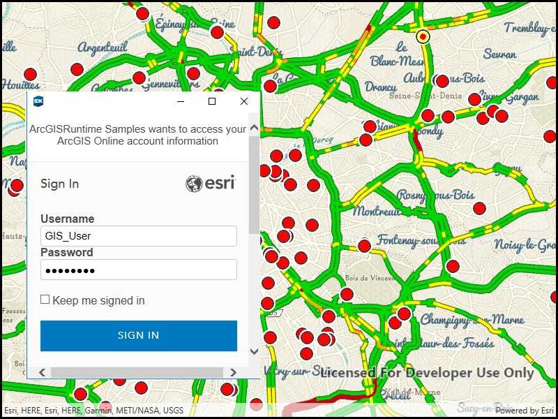
Authenticate with ArcGIS Online (or your own portal) using OAuth2 to access secured resources (such as private web maps or layers).

Use case
Your app may need to access items that are only shared with authorized users. For example, your organization may host private data layers or feature services that are only accessible to verified users. You may also need to take advantage of premium ArcGIS Online services, such as geocoding or routing services, which require a named user login.
How to use the sample
When you run the sample, the app will load a web map which contains premium content. You will be challenged for an ArcGIS Online login to view the private layers. Enter a user name and password for an ArcGIS Online named user account (such as your ArcGIS for Developers account). If you authenticate successfully, the traffic layer will display, otherwise the map will contain only the public basemap layer.
How it works
- Set the
AuthenticationManager'sChallengeHandler. - Create a
ServerInfospecifying the portal URL, client ID, and redirect URL. - Register the server with the authentication manager.
- Load a map with premium content requiring authentication to automatically invoke the authentication handler.
Relevant API
- AuthenticationManager
- OAuthConfiguration
- PortalItem
- ServerInfo
Additional information
The workflow presented in this sample works for most SAML based enterprise (IWA, PKI, Okta, etc.) & social (facebook, google, etc.) identity providers for ArcGIS Online or Portal. For more information click here. On UWP, some authentication workflows that don't support WebAuthenticationBroker may require a custom IOAuthAuthorizeHandler.
For additional information on using Oauth in your app, see the Mobile and Native Named User Login topic in our guide.
Tags
authentication, cloud, credential, OAuth, OAuth2, portal, security
Sample Code
// Copyright 2017 Esri.
//
// Licensed under the Apache License, Version 2.0 (the "License"); you may not use this file except in compliance with the License.
// You may obtain a copy of the License at: http://www.apache.org/licenses/LICENSE-2.0
//
// Unless required by applicable law or agreed to in writing, software distributed under the License is distributed on an
// "AS IS" BASIS, WITHOUT WARRANTIES OR CONDITIONS OF ANY KIND, either express or implied. See the License for the specific
// language governing permissions and limitations under the License.
using ArcGIS.Helpers;
using Esri.ArcGISRuntime.Mapping;
using Esri.ArcGISRuntime.Portal;
using System;
using System.Threading.Tasks;
using System.Windows;
namespace ArcGIS.WPF.Samples.OAuth
{
[ArcGIS.Samples.Shared.Attributes.Sample(
name: "Authenticate with OAuth",
category: "Security",
description: "Authenticate with ArcGIS Online (or your own portal) using OAuth2 to access secured resources (such as private web maps or layers).",
instructions: "When you run the sample, the app will load a web map which contains premium content. You will be challenged for an ArcGIS Online login to view the private layers. Enter a user name and password for an ArcGIS Online named user account (such as your ArcGIS for Developers account). If you authenticate successfully, the traffic layer will display, otherwise the map will contain only the public basemap layer.",
tags: new[] { "OAuth", "OAuth2", "authentication", "cloud", "credential", "portal", "security" })]
[ArcGIS.Samples.Shared.Attributes.ClassFile("Helpers\\ArcGISLoginPrompt.cs")]
public partial class OAuth
{
// Constants for OAuth-related values.
// - The URL of the portal to authenticate with
private const string ServerUrl = "https://www.arcgis.com/sharing/rest";
// - The ID for a web map item hosted on the server (the ID below is for a traffic map of Paris).
private const string WebMapId = "e5039444ef3c48b8a8fdc9227f9be7c1";
public OAuth()
{
this.Loaded += (s, e) => { _ = Initialize(); };
InitializeComponent();
}
private async Task Initialize()
{
try
{
// Call a function to set up the AuthenticationManager for OAuth.
ArcGISLoginPrompt.SetChallengeHandler();
// Connect to the portal (ArcGIS Online, for example).
ArcGISPortal arcgisPortal = await ArcGISPortal.CreateAsync(new Uri(ServerUrl));
// Get a web map portal item using its ID.
// If the item contains layers not shared publicly, the user will be challenged for credentials at this point.
PortalItem portalItem = await PortalItem.CreateAsync(arcgisPortal, WebMapId);
// Create a new map with the portal item and display it in the map view.
// If authentication fails, only the public layers are displayed.
Map myMap = new Map(portalItem);
MyMapView.Map = myMap;
}
catch (Exception e)
{
MessageBox.Show(e.ToString(), "Error starting sample");
}
}
}
}