Use pictures for markers.
Use case
When marking geoelements on a map, using custom, unique symbols can be helpful for highlighting and differentiating between locations. For example, a tourism office may use pictures of landmarks as symbols on an online map or app, to help prospective visitors to orient themselves more easily around a city.
How to use the sample
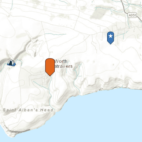
When launched, this sample displays a map with three picture marker symbols. Pan and zoom to explore the map.
How it works
- Create a
PictureMarkerSymbolusing the URL to an online or local image. - Create a
Graphicand set its symbol to the picture marker symbol.
Relevant API
- PictureMarkerSymbol
Offline Data
To set up the sample's offline data, see the Use offline data in the samples section of the Qt Samples repository overview.
| Link | Local Location |
|---|---|
| orange_symbol Png File | <userhome>/ArcGIS/Runtime/Data/symbol/orange_symbol.png |
About the data
The picture marker symbols in this sample are all constructed from different types of resources:
- Campsite symbol constructed from a URL
- Blue pin with a star stored in the resource folder that comes with the application
- Orange pin created from a file path on disk (which is written to disk when the app starts and cleaned up when the app closes).
Tags
graphics, marker, picture, symbol, visualization
Sample Code
// [WriteFile Name=Picture_Marker_Symbol, Category=DisplayInformation]
// [Legal]
// Copyright 2016 Esri.
//
// Licensed under the Apache License, Version 2.0 (the "License");
// you may not use this file except in compliance with the License.
// You may obtain a copy of the License at
// http://www.apache.org/licenses/LICENSE-2.0
//
// Unless required by applicable law or agreed to in writing, software
// distributed under the License is distributed on an "AS IS" BASIS,
// WITHOUT WARRANTIES OR CONDITIONS OF ANY KIND, either express or implied.
// See the License for the specific language governing permissions and
// limitations under the License.
// [Legal]
#ifdef PCH_BUILD
#include "pch.hpp"
#endif // PCH_BUILD
// sample headers
#include "Picture_Marker_Symbol.h"
// ArcGIS Maps SDK headers
#include "Envelope.h"
#include "Graphic.h"
#include "GraphicListModel.h"
#include "GraphicsOverlay.h"
#include "GraphicsOverlayListModel.h"
#include "Map.h"
#include "MapQuickView.h"
#include "MapTypes.h"
#include "MapViewTypes.h"
#include "PictureMarkerSymbol.h"
#include "Point.h"
#include "SpatialReference.h"
#include "Viewpoint.h"
// Qt headers
#include <QStandardPaths>
#include <QString>
#include <QUrl>
#include <QtCore/qglobal.h>
using namespace Esri::ArcGISRuntime;
// helper method to get cross platform data path
namespace
{
QString defaultDataPath()
{
QString dataPath;
#ifdef Q_OS_IOS
dataPath = QStandardPaths::writableLocation(QStandardPaths::DocumentsLocation);
#else
dataPath = QStandardPaths::writableLocation(QStandardPaths::HomeLocation);
#endif
return dataPath;
}
} // namespace
Picture_Marker_Symbol::Picture_Marker_Symbol(QQuickItem* parent) :
QQuickItem(parent),
m_dataPath(defaultDataPath() + "/ArcGIS/Runtime/Data")
{
}
Picture_Marker_Symbol::~Picture_Marker_Symbol() = default;
void Picture_Marker_Symbol::init()
{
qmlRegisterType<MapQuickView>("Esri.Samples", 1, 0, "MapView");
qmlRegisterType<Picture_Marker_Symbol>("Esri.Samples", 1, 0, "Picture_Marker_SymbolSample");
}
void Picture_Marker_Symbol::componentComplete()
{
QQuickItem::componentComplete();
// find QML MapView component
m_mapView = findChild<MapQuickView*>("mapView");
m_mapView->setWrapAroundMode(WrapAroundMode::Disabled);
// Create a map using the topographic basemap
m_map = new Map(BasemapStyle::ArcGISTopographic, this);
// Set map to map view
m_mapView->setMap(m_map);
// set initial viewpoint
m_map->setInitialViewpoint(Viewpoint(Envelope(-229100, 6550700, -223300, 6552100, SpatialReference::webMercator())));
// create graphics overlay
m_graphicsOverlay = new GraphicsOverlay(this);
// create a campsite symbol from a URL
PictureMarkerSymbol* campSymbol = new PictureMarkerSymbol(QUrl("https://static.arcgis.com/images/Symbols/OutdoorRecreation/Camping.png"), this);
setWidthAndHeight(campSymbol, 38.0f);
Point campPoint(-228835, 6550763, SpatialReference::webMercator());
addGraphic(campPoint, campSymbol);
// create a blue symbol from a local resource
PictureMarkerSymbol* blueSymbol = new PictureMarkerSymbol(QUrl("qrc:/Samples/DisplayInformation/Picture_Marker_Symbol/blue_symbol.png"), this);
setWidthAndHeight(blueSymbol, 80.0f);
Point blueSymbolPoint(-223560, 6552021, SpatialReference::webMercator());
addGraphic(blueSymbolPoint, blueSymbol);
// create an orange symbol from a file path
PictureMarkerSymbol* orangeSymbol = new PictureMarkerSymbol(QUrl(m_dataPath + "/symbol/orange_symbol.png"), this);
setWidthAndHeight(orangeSymbol, 64.0f);
Point orangeSymbolPoint(-226773, 6550477, SpatialReference::webMercator());
addGraphic(orangeSymbolPoint, orangeSymbol);
// add GraphicsOverlay to MapView
m_mapView->graphicsOverlays()->append(m_graphicsOverlay);
}
void Picture_Marker_Symbol::addGraphic(Point &point, PictureMarkerSymbol* symbol)
{
// create graphic
Graphic* graphic = new Graphic(point, symbol, this);
// append to graphicsoverlay
m_graphicsOverlay->graphics()->append(graphic);
}
void Picture_Marker_Symbol::setWidthAndHeight(PictureMarkerSymbol* symbol, float size)
{
symbol->setWidth(size);
symbol->setHeight(size);
}